
Maturing iPhone apps, troubled ENC edition
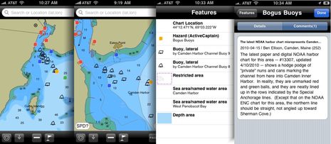
Pardon me if I use an entry on the improving state of marine iPhone apps to illustrate my concerns about NOAA’s local chart screw ups, but it works (I think). Navimatics Charts&Tides 3.6.2 was the first charting program of any sort I’ve seen that includes NOAA’s first 1:20,000 ENC for Camden Harbor, but it will be confusing fog bound visitors soon! Those semi-invented channel buoys that I first saw on the raster chart are worse here, given equal graphic weight with real navigation aids, more precise looking wrong locations, and all without the “Priv aids” label that might help a navigator sort things out…
This is not Navimatics’ fault at all; a chart update to Coastal Explorer gave me another view of the new ENC, and it looks essentially the same. Yes, they are labeled “Camden Harbor Buoys…” but that’s not the same as “Priv aids.” Of course a saving grace for both CE and C&T is that they can both also display Active Captain info, so someone like me can warn others about the confusion. Tapping for more data info is much improved in this latest version of Charts&Tides, by the way, and the ability to turn the chart seems easier and hence more useful.
But before I get into a few more marine apps improvements I’m seeing, I have more to say about ENCs. In this new one of Camden, for instance, NOAA has added a lot of detail about the piers and float systems in the Inner Harbor, which would be neat except that they made many mistakes. Then there’s my further research into those those “cribs” on the Kennebec River, a danger pretty well charted on paper and RNC, but de-emphasized in the ENC format, a de-emphasis often copied by the private chart makers. I’m really beginning to wonder about the ENC process, and hope you all will be on the lookout for dangers that aren’t well displayed on them, or other oddities (and please take screen shots). All of which is rather ironic today as I stumbled onto a newsgroup thread in which several boaters are ranting about the danger of using anything but “official” navigation data.
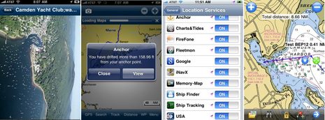
Well, balderdash; I’m sure NOAA and other HO’s are very well intentioned, but I’ll use every bit of data I can find to better understand where I am and what I’m getting into with my vessel. That’s why inexpensive smart phone apps that can show the most updated charts, perhaps in a format you don’t have otherwise, and optional data, are great. And also why I’m delighted to report that the new new Navionics Mobile beta app includes the panoramic port photos normally only seen on their high end card packages, like the Camden Harbor aerial shot below left. I hesitate to even mention a new all-in-one Navionics app, as the first take I previewed never made it out of beta, but the latest design is even better, and I’m told it will be real soon.
I was also pleased to see how quickly Memory Map picked up the latest local raster chart, below right, and how easy its waypoint/route making tools have gotten. And, yee-ha, note that there’s a new Anchors Away iPhone anchor alarm program out and thanks to its OS4 awareness, it can do its thing in the background. I’m hoping that all the iPhone charting apps will be able to track in the background eventually (like Android apps can ;-), and there are several interesting new non-charting iPhone apps I’ve been meaning to write about. More soon.
 PS In response to my chart issue request, “Sherri & Nick & Sweet Time” sent this radar overlay screen shot of the ICW between Charleston and Georgetown, SC. They said it looked the same on a PC with ENC and RNC charts. Of course their observations about where the land is, and where the water isn’t, are not official (see comments).

All these charting apps have a hidden benefit: NOAA charts are now in the hands of thousands of more users.
It would be wonderful if they could easily report errors to NOAA. Perhaps a hundred reports of the same error might prompt a quicker correction.
I can’t figure out how to report errors to NOAA at all, and I volunteered to do it regarding those channel buoys on behalf of the Harbor Committee I sit on. Does anyone know of an online form for reporting NOAA chart errors?
PS I’ve noted before that Navionics Mobile has a neat function for emailing in mistake reports, but I think it only applies to mistakes Navionics makes in copying official data or adding their own. I’m afraid that Garmin, Navico, Jeppesen, and Navionics are all working now to copy those misplaced and misnumbered buoys (and the invented harbor piers), and won’t feel comfortable about correcting them until NOAA does. It could take years to get that mess fully straightened out. Funny that I used to use that very channel as an example of important stuff the chart might not tell you, but photo maps often could.
I have seen this link on the NOAA site. Not sure if it is what you are looking for or not. http://ocsdata.ncd.noaa.gov/idrs/discrepancy.aspx
That’s it, Carl; thanks so much! It’s a well done form, too, and you can even upload sample images to NOAA, which I did. It will be interesting to see how quickly they’re able to respond, and then how long it takes to straighten the charts out.
Panbo…fixing nautical charts, one buoy at a time! Well done, Ben!
You should try the new Simplified symbol setting in Navimatics so the red buoys display in red, etc. Maybe it’s just me but I dislike the traditional IHO black and white symbology.
United States Power Squadrons (USPS) has a ~40 year old partnership with NOAA called Cooperative Charting through which USPS members provide high quality chart corrections to NOS. Corrections are generated following strict procedures and are submitted to NOS electronically after local review. Corrections can be approved and posted to the online versions of charts in a matter of weeks.
It appears from their website that the Mid-Coast Sail & Power Squadron in your area (Rockland-Rockport-Camden) has an active Cooperative Charting program. I’d suggest you contact the squadron commander, George Sayre (207-593-9064, [email protected]) to see if his trained folks can get tne needed changes made.
Crowdsourcing of navigation data, or anything else related to safety, is a dreadful idea, roughly akin to unprotected sex with strangers in a bus terminal. It’s one thing to take local advice under advisement, especially when you know the adviser, but another thing entirely to take anonymous anecdotal advice at face value.
My own experience (from an error I reported) is that NOS/USCG promptly issues a Notice to Mariners when it gets a credible and verifiable report of a significant error. The bigger problem is that few recreational boaters take any notice of them.
John
Wow…I surely have a different experience. January will make 4 years we’ve been collecting navigation and cruising information from users. What I’ve found in my own cruising is that I totally rely on the user-generated data well beyond whatever the NOAA charts show. So much of the charts in the cruising areas haven’t been touched by NOAA in decades. Want to know where the next LNTM entry will be? Find an ActiveCaptain hazard. Ben’s example for Camden harbor is a perfect one of someone with true local knowledge providing it to others. Watch a LNTM entry appear there in a couple of months (after the Maine cruising season is over).
Can the data just come randomly from people? Of course not. There needs to be a way to gauge the experience of the person writing the entry. Click on the first screen shot at the top. You’ll see that it was made by Ben Ellison of Camden, Maine with 252 points. The points are the number of accepted updates and reviews he has made in the past and 252 means he’s done a lot. Knowing he’s from the local area make the data pretty highly qualified and something to be noticed no matter what the charts show.
Now imagine a piece of data with 9 different people giving input – all rated with a great opportunity to evaluate the information. There are many markers like that including one on a section of the Alligator River where the NOAA charts have been wrong for a couple of years now. Years! If you pass through there, you’ll hear calls to the towing companies every day. Here’s a direct link to see the spot:
http://activecaptain.com/X.php?lat=35.940907&lon=-75.990543&t=n&z=14
So while I think I’ll be staying away from bus terminals for almost any activity, I’ll continue to use and rely on navigation information sourced by real experts – the ones out there with local knowledge.
Same issues up in Canada.
for example…2004 Navionics chip for BC waters has more depth contours than 2005 Navionics chip .
Reason?Not Navionics fault..some bureaucrat in Ottawa decided to save a few pennies and remove them and never asked us boaters what those little sqiqqlly lines on those maps was about!arrrghhhhh
Hot diggity! a Debate! This time its the elites vs. the Hive! Don’t I wish this question were more closely rooted in reality.
Tell me, John Navas, why your solution didn’t work in Camden Harbor?
If your task is to sweep out the hangar deck, would you rather have one really good broom, or a hundred half serious ones?
In addition to submitting on the link above, I would suggest talking to the regional NOAA “Nav Manager.” Ed Martin is still standing in until the position is filled.
http://www.nauticalcharts.noaa.gov/nsd/reps.htm
The regional people are there to help with all sorts of issues.
-kurt
Yikes…out of the frying pan (of whale meat), and into the fire. This evening John Navas added this to the Panbo link on his site: “warning: some of the advice is dangerous,” highlighted in red even!
http://sail.navas.us/#Blogs
***********************************************
Well, John, I think we both presented our cases sufficiently here and at rec.boats.electronics. Oddly enough, I think we were both delivering unofficial safety related advice about using unofficial advisory data. And in a similarly meta manner, our readers now face a classic dilemma of the big vague phenomenon you like to call crowdsourcing, i.e. which of two contradictory sources is correct (if either):
1) A wise navigator never uses anything but official navigation data because unofficial data may lead to STDs or worse.
2) A wise navigator uses every bit of data available, but trusts none of it completely.
I’m hoping that maybe our argument illuminated those divergent points of view, and I thank you for that, John.
For more info on the TeamSurv project have a look at my post on rec.boats.lectronics – I won’t clog up Ben’s blog by cutting and pasting it here. http://groups.google.co.uk/group/rec.boats.electronics/msg/cd6dcf9e8f5f9757?hl=en-GB.
Amongst all the usual usenet crud, there are some useful observations in the thread.
One other thought: how many of you how just want to use official data use charts from C-Map or Navionics? Both of these companies incorporate signifcant amounts of unofficial data from cruising guides etc in their harbour scale charts (I’m not sure about Garmin, but suspect they do as well). For an interesting exercise to see this, take an area popular with leisure but not with commercial traffic, look at the chart coverage using C-Map’s leisure charts, and then at the same area using their S-57 charts for commercial shipping, and you’ll find the latter have much less detail. So, to continue the recent controversial debates here, perhaps you should all switch off your chart plotters in coastal waters in case you become tainted with unofficial data!
Tim
Thanks to Jim Starr and Kurt for references to concerned parties who might help straighten out our local harbor chart (and also to those who have e-mailed suggestions). I wrote to both recommended parties this morning.
And I want to recommend reading Tim Thornton’s long post this morning at rec.boats.electronics explaining the whys and hows of “crowd sourced” depth data. And it’s good to see the mood there turn less pedantic.
Sherri & Nick & Sweet Time screenshot is just what we saw a month ago in the same area. This is only one of several places on the ICW where the NOAA charts are wrong. I agree with Jeff Siegel that user generated data is most valuable. User generated data is also available from Cruisersnet.net, Skipper Bob, and probably others. None are always accurate, but add them all together and you have a pretty good idea of what is out there
The problem with NOAA ENC and Raster charts is that there has been a lot of dredging on the ICW in the past couple of years, and the new channels are not always in the same place, eg: Stewart Fla, Alligator R. NC. But in every case markers have been moved or new ones added. In our trip up the ICW in the past month, I never felt that I was being led astray by misplaced markers. As always, follow the markers and not the charts.
Having said that, I find the NOAA charts accurate 98% of the time. We use both the printed and E versions exclusively. And that the E versions are available for free is even better.
While NOAA is responsible for charting buoys and navigation aids, they are not the source of that data. The Coast Guard provides navigation aid information to NOAA using their ATONIS data base. Charted positions and characteristics of Coast Guard navigation aides are then extracted from the data base and charted. If errors are seen in aids to navigation, this should be immediately reported to the local Coast Guard.
Display of this information is a whole other story. Unless you are using a “type-approved” Electronic Chart Display and Information System (ECDIS), you are at the whim of the computer programmer as to what information is displayed, and how it is displayed (i.e. what receives cartographic precedence). The International Hydrographic Organization (IHO) controls the data requirements for ENC’s (data) and the International Maritime Organization (IMO)control all display requirements. The vendors creating these applications are not beholding to any of these standards.
Rick, thank you very much for commenting on Panbo. I want to make it perfectly clear that I hold no animosity toward NOAA at all. Your mission seems vast, and difficult.
But I do have a lot more questions about the specific local chart problems I’m seeing along with more general ones about ENC presentation and NOAA’s quality control process. I intend to write a separate entry about it next week, but I should get a chance this weekend to collect some data on just where those channel buoys are set now, which is close to where they’ve always been set.
First, happy 4th of July to all. Thanks to Rick Brennan for his excellent summary. And Ben, Rick and his staff are a great source for the latest re: the international standards. Best to all, and be safe out there.