AIS at Lauderdale, lots

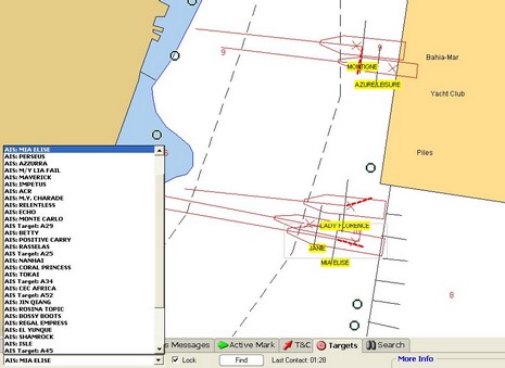
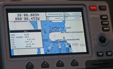
The above snip from a Nobeltec VNS screen (full size here) shows how some of the megayachts tied stern-to at the Ft. Lauderdale show looked AIS-wise. There are obviously a few errors either in the vessel dimensions or GPS locations (the red “X”s) or the underlying chart, but mind you this is a very zoomed-in view. I saw lots of boaters looking at screens like this and realizing what AIS can do for them. I also got to go aboard several of the megayachts and can tell you that the crews on those boats are also impressed with the technology. The Nobeltec exhibitors were using the Nasa/Si-Tex receiver with a regular VHF antenna tied to the top of their booth inside a giant steel framed tent, and were still getting some 30–40 targets within about a ten mile radius. The Si-Tex ColorMax plotter shown below was similarly set up and getting lots of targets.
The show, by the way, was better attended by exhibitors and customers than I had guessed, and I’m glad I went. More to come.


My experience on the San Francisco bay with freighter traffic is the extraneous data fields of destination and vessel size are oft incorrectly reported.
As pointed out by others the same AIS receiver that Nobeltec is rebranding can be found here for a $100 less.
http://makeashorterlink.com/?H49C22E1C
I am curious to know when Garmin will finally update the marine’s Chart Ploters to support AIS. I think that the minimum suport must include the NMEA support to AIS receivers like the NASA engine, for plotting the ships on the nautical chart and displaying the radar like screen, together with the CPA/TCPA, alarm setings etc.
The NASA AIS receiver only listens for one GPS NMEA message: $GPRMC. This message provides position, speed and course. All marine Garmin models are capable of transmitting this message over their serial (read: not USB) port.
Now it would be nice if Garmin would integrate AIS into some of their larger GPS.
You are wrong. The NASA AIS receiver SENDS the NMEA !AIVDM witch is the AIS message giving the ships position, course, speed etc. The Garmin units SENDS the $GPRMC message and others $GP (gps) NMEA position related messages, to devices like autopilots, VHF radios etc. But the Garmin units DOES NOT RECEIVE the !AIVDM message, to plot the ships on the screen etc. This is what I am asking garmin to do.
I stand by my original statement that the NASA AIS engine only RECEIVES (listens) for one NMEA GPS message ($GPRMC). I made no comment on what NMEA message Garmin GPS listen to. You are correct the Garmin GPS currently do not RECEIVE the !ADVDM ITU formatted message.
I don’t expect Garmin will add support for the !ADVDM message, but will instead add an AIS receiver into a GPS model.
What are your premisses and sources to state this? That is, why You do not expect Garmin to suport the standard NMEA AIS messages? As seen here, Si-Tex already suports it, at last to receive the ships data and plot them on the chart, what I regard very very usefull.
I think there is some confusion here. The NASA AIS engine receives AIS messages over the air and converts them to standard AIVDM messages on its serial port. It does not output anything other than AIVDM to my knowledge.
It may accept a GPRMC message input to its serial port, but to what purpose? The receiver doesn’t need to know its position. Unless it has a pass-through function?
bob
Yes the NASA AIS engine works as a simple multiplexor. That is it will pass through the $GPSRMC message from a connected GPS at 4,800 baud and put it in the AIS NMEA stream which is at 38K baud. The idea being you don’t have to tie up two ports on your laptop. The downside to using the GPS connection on the NASA AIS engine is other useful GPS messages are stripped such as $GPGSV (satellite info).
I believe Garmin is more interested in promoting their proprietary marine network as such will integrate an AIS receiver into one of their higher end models.
Yes, I think you are rigth, pheraps this and the delay of Class B specs are the reason behind the delay of Garmin/Raymarine AIS launch.
Thanks
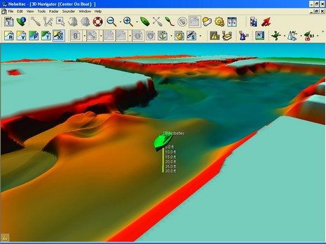
I have been in contact with Garmin- they do not seem to be very interested in keeping the maked. Typical conservative- I belive another company will see the need for yachtsmen. We are ready for plotters integrating AIS end 3d echo!!!!
RAF
I am on the brink of buying a Garmin 2106. Their website states it is compatible with NMEA 0183 AIS receivers. I have the NASA receiver; their website states it uses NMEA 2000.
My question is, will these units work together to provide AIS info if they use different NMEA ?
Many thanks Paul
Paul, The NASA receiver outputs NMEA 0183, not NMEA 2000. Why NASA has that misinformation on its site absolutely baffles and annoys me (and I’ve asked about it).