
Bent at Burnt Coat, another cautionary chart tale

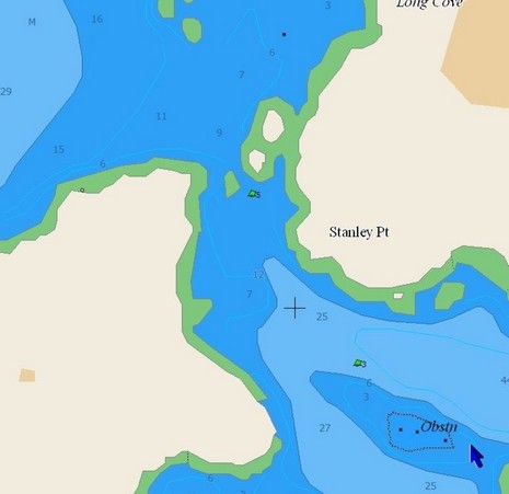
This is what the gentleman saw on his Raymarine plotter, bigger here, which is why he says he cut between Harbor Island and Can “5”, and that’s why he’s now hauled out having his bent props, and maybe more, repaired. Ouch!
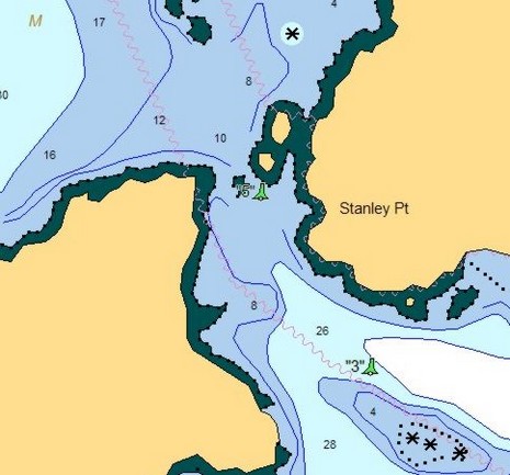
Navionics missed a ledge, a pretty important one. In fact, the thing is vaugely drawn on the official NOAA raster chart, heavily zoomed below (and also showing my fortunately uneventful track through the same beautiful area last summer), but still every other brand of vector chart I looked at did manage to get it right. (The images futher below—C-Map, Garmin, and then Nobeltec—all show the ledge and are interesting to see side-by-side, but note that how they display varies a lot from one device to another and also according to how variables are set).
Now, I believe that electronic charts are pretty reliable (the Lowrance NauticPath and ENC display issues aside, probably all fixed by now anyway). But I also suspect that every vendor—even NOAA (by the way, the 1:40,000 ENC for this area hasn’t been issued yet)—makes mistakes. Just like the splash screens and navigation manuals say, reliance on a single data source is not a good idea (especially when the bouyage appears confusing, which in this case will get another entry).
In the meantime, I’ve learned from Navionics that this error has been reported and will be corrected in the next regular annual update if not before.


That is an interesting lesson. I may use some of your screen shots in the U.S. Power Squadron Chart Smart Class that I teach. It is an excellend lesson that drives home two points: You must have a deep understanding of the U.S. ATON, and you should not rely on digital charts 100% of the time. If the skipper had known which side of his vessel to pass that buoy, this unfortunate accident would not have occured.
And red, right, returning, too!