Summer bummer, please don’t blame charts or electronics
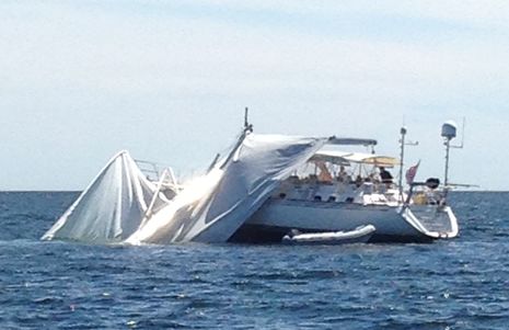 While my friend Leonard Lookner was first to come upon this distressing scene Wednesday afternoon, he too was sailing and thus, a powerboat just behind him was first to offer assistance. But it was Leonard’s iPhone photos that fueled a local PenBay Pilot news piece, which then prompted an interesting SailNet discussion. Of course, it was suggested that marine electronics or digital charts were somehow to blame – allegations I’d like to refute, and I also want to report on how well this worse-than-it-even-looks situation actually turned out. Plus, getting reminded to be careful out there is never a bad idea…
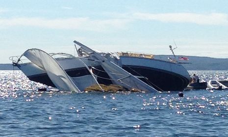 When the Hylas 70 hit the submerged ledge it was only about an hour or two after high tide, so the salvage operation not only involved removing a large carbon fiber rig, but also managing the yacht as about eight feet of tide went out from under a very precarious perch. In fact, what I’ve heard is that the teams from Wayfarer Marine and Prock Marine delayed the mast clearing operation when they realized that it was helping to hold the boat in place, but eventually the last shreds of carbon around the gooseneck gave way and she lurched hard to starboard, almost throwing a couple of salvors off the deck.
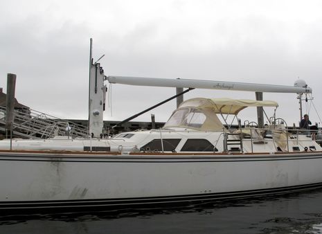 The good news? As I understand it, none of the crew or charter guests on board Archangel were seriously hurt, and the boat seemed to come out of it pretty well, too. Yes, she looked quite forlorn when I spotted her tied up at Wayfarer Thursday morning, but there were no emergency pumps in sight, and it’s said that she motored back herself once the tide came back up and Prock had used a crane barge to remove the mast. Credit to Hylas for a wicked strong hull and especially to the Wayfarer and Prock teams. Apparently, the Coast Guard investigators on the scene were amazed at our local capablities, but I’m not!
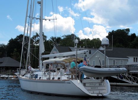 Then again, the photo above shows how snappy Archangel looked as she departed Camden just a few days ago, and who knows what internal damage the surveyors will find. The photos also seem to support the theory expressed on Sailnet that the large lower aperture for the GMT in-mast furling might have created a weak spot in the rig. I have no opinion on that subject, but this was the early Sailnet comment that got my attention:
I have read a few articles on how our reliance on electronic charts and plotters have increased the groundings, accidents, and sinkings. Once, when paper charts were the norm and you had to take physical readings, you never really knew exactly where you were. You had to fudge it a bit and give known hazards (and some suspected ones) a wide berth. With the “accuracy” of electronic charts and GPS, many sailors and powerboaters are cutting it a lot closer, thinking that what they see on the chart is really there and that the GPS is telling them exactly where they are on that chart. This does not take into consideration shifting bars, mismarked hazards, and even other boats that may have sunk there.
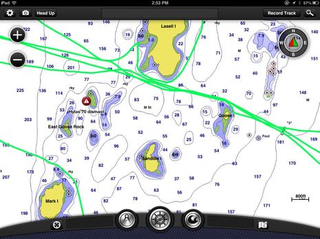 I’d really like to know more about the alleged articles showing how chart plotters are causing more groundings and sinkings (anyone?), because I am extremely dubious. And if there really is a statistical increase in accidents, which I doubt, how would anyone separate the presence of electronics from the absence of experience that so often distinguishes modern boaters from the old school? I also roundly reject the notion that knowing less about where you are on the water is somehow safer, and I’ve tried both. I think that what makes you safer is knowing the tools you have, and we have very good tools these days.
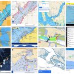
Check out some recent Gizmo tracks shown on the Garmin BCM app screen above. I only had them handy on my iPad because I was experimenting with Garmin data transfer recently, and I certainly didn’t create them to make a point, but note how consistently Gizmo stayed north of the clearly charted ledge that the Hylas hit. It didn’t involve “giving a wide berth” to every possible hazard, but rather driving quite close to the deep, bold southern tip of Lasell Island to stay in safe water. I’ve done this many hundreds of times over the last 40 years, starting with only paper charts, a compass, and a ‘flasher’ depth sounder. Nowadays, GPS, chart plotting, and radar make the passage more relaxed and help me keep my eyes out of the boat to better see the lobster buoys (and enjoy the sights). And an NMEA 2000 depth sensor mounted on Gizmo’s forefoot, along with Simrad StructureScan, help me make some of those interesting little side trips. (Note that I purposely went close to that submerged rock just above Mark Island, because I’ve never seen it uncover and was curious if there’s really something there, which there is.)
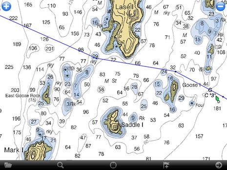 Above is the NOAA paper chart for the Lasell Island passage seen as an electronic “raster” chart (or RNC for raster nautical chart) in the app Memory-Map, with the commonly used route overlaid. I’m very comfortable with this format, and often find that it emphasizes the most important data points. Note, for instance, how the offending ledge, is annotated with “(10)”, which means that the “rock which covers and uncovers or is awash at low water” actually has a “drying height” of 10 feet. (Familiarity suggests that it’s more like 6 feet with our normal 10 foot tide range, but the idea is good, and you have to drill down in other charts to see it.)
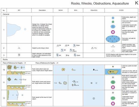 I was glad to see that very few SailNet commenters responded to the idea that Archangel’s skipper might have avoided the grounding by using paper charts — and one, who I know to be a great sailor, admitted that he’d hit the same ledge with a paper chart in his lap! Several also recommended Nigel Calder’s excellent How to Read a Nautical Chart
, but I’ll add that you can freely download the underlying U.S. Chart No. 1 here and the latest edition includes a column of ENC symbology that unfortunately did not make it into Nigel’s 2nd edition.
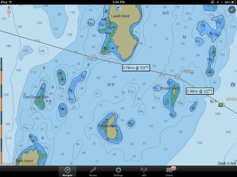 Above is a NOAA ENC (for electronic navigation chart) displayed by the interesting app SEAiq USA. Because they are vector charts they can look different from one charting engine to another and you can also customize the look to some degree. SEAiq offers excellent ENC control, I think, and doesn’t this chart look useful for getting through that passage?
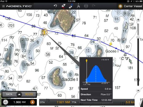 Here’s the NOAA raster overlaid with the PhotoFusion satellite maps that I so like in TimeZero products like the Nobeltec TZ. I think that this sort of land and shallow water detail can help a visitor understand these waters like a local does. Note, too, the overlaid tidal current arrows (though perhaps the only positive of all the lobster trap buoys is that you can use them to see what the current is doing every 30 feet or so 😉
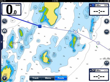 The Navionics Mobile vector chart utilizes bold colors well, I think. I also note that this and Garmin’s show an always-dry area at the end of that long ledge extending southwest from Lasell, which is true and also very useful information when you’re trying to pass close at high tide. I don’t understand why we’re not also seeing that on the NOAA charts, but it does seem to be an example of commercial electronics being a dite better.
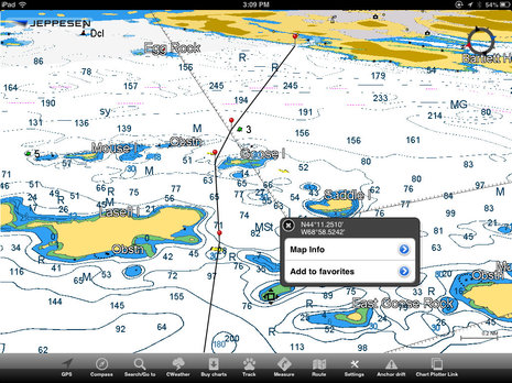
Finally, the screen below shows C-Map charting in the app Plan2Nav, but I’ve put it in course-up perspective view, which would look better if I’d actually been underway. Not many boaters like this 3D style, but I think it can be a useful tool when understood. The overall point is that there were many electronic resources that could have helped Archangel’s captain get through that passage without a fuss. He screwed up plain and simple, and likely feels terrible about it (though I’ve heard he was an active and valuable part of recovery operation). I’ve screwed up, too, and probably will again. Perhaps the most interesting conjecture on that SailNet thread concerns the multi-tasking stress of running a high-end charter operation, but if you want more knee-jerk anti-electronics sentiment — “Another computer assisted grounding, perhaps?” — check out the CruisersForum discussion. Am I off-base to be annoyed by this stuff?





Off base? Not in my opinion. The widespread tendency to ascribe all accidents and disasters to some “new fangled technology” is just the Luddites amongst us trying desperately to justify their backward ways. I seem to recall reading in Sail Magazine a few years ago where two of these folks “no unreliable electronic gee-wiz GPS for me – celestial is all I need”) managed to run both of their boats up on a reef in broad daylight – because it had been cloudy for a couple of days and their DR was off. GPS would have saved them, of course.
The only increase in accidents I’ve heard regarding GPS and newer navigational techniques was told to me several years ago by a USCG rating in San Diego, and he told me that they had seen an increase in bouy strikes, supposedly because of folks using the bouy lat/longs as waypoints.
In my experience, the only possible negative of hi-reliability electronic navigation I’ve noted is an increase in the number of boats motoring along with no one on lookout – and I really don’t know if that’s because there are more idiots – or electronic navigation makes it easier..:-)
No Ben, I don’t think you are off-base in the least! Electronic charts are tools and tools are only as good as the workman that uses them.
Tools are tools. Blaming them for tool-wielder errors is foolish.
But here’s the deal, Ben. You’re old (relatively). I’m old (also relatively). We have paper, sextant and “flasher” (or God help us, lead line) experience in our past. We have pilotage and even an ability to sniff land. We watch birds, wave sets, cloud formations and distant dark lines on the horizon. We make *better use* of modern tools like GPS and AIS *precisely because* we come from a background of sketchy, seat-of-the-pants navigation and the habit of watchkeeping.
Someone learning to sail today may (and frequently does) lack that, from what I have seen. I see it on the water, when autopiloted boats bong off slightly off-station buoys input as waypoints without knowledge of “offing”. One hears of pretty obvious tidal errors or of plowing into the mole built last year (the e-chart being 18 months old).
So the tools are great, but a tool doesn’t care if the hull is holed and the rig is down. Only a holistically aware skipper cares about that. A prudent skipper uses ALL means at hand. GPS is a “mean”. Plotters are “means”. So are bearings, soundings and watching for weird patterns on the water that suggest something heavy and solid below.
See “USS Guardian”.
Nope… you’re not off-base getting annoyed, but you seem to take it personally. What’s with that? This kind of knee-jerk anti-electronics reaction is normal, but also unwarranted in this case, I think. My assumption here is the skipper had run this bit of water many times before, had lots of other things to think about, and simply took his eye off the ball. Over-familiarity, and taking stuff for granted, causes more trouble than over-reliance on electronics, at least in my own experience. But over-reliance on electronics does create trouble for some people in some situations, IMHO.
What’s the saying?
A prudent mariner does not rely on any one source of navigation information.
A couple more waypoints with a small dog-leg in the passage plan and there wouldn’t have been a problem, a waypoint on a lasel/fastgoose transit perhaps.
GPS is great ( furuno gp32) with paper charts in my Yeoman Sport , plus the furuno 4100 depth and a good pair of compass binos. I assume the weather was reasonable, it’s when you throw in rough weather that things get ‘interesting’.
At least there were no casualties ,thank God.
As for the comment about autopiloting boats without a master at the helm, if you see one report to a coastguard, there were two fatalities a couple of years ago when a motor yacht killed two people in there sailing boat while the motor boat was on autopilot and the owner below ‘entertaining’ a lady. Prison!
It’s common sense to question why the boat was in that area in the first place. Perhaps it is the unconscious tendency for a sailor to stay the course, unlike a power boater who could more easily steer around obstacles or avoid a tricky zone altogether; even wiggle around the rocks on the chart plotter. But, after spending some time the next day with the guests on the dock, we learned that the captain was merely dodging a lobster pot. A mess of lobster pots festooned over rocks is not a place you where you want to attempt to hold a straight tack. But that’s what sailors tend to do – hold the course.
A chart plotter should be positioned so that you can observe what’s going on around you. . It’s like flying an airplane. You’ve got to be able to quickly look down at your instruments and up at your surroundings. It should be an almost simultaneous action.
Even though the boat’s earlier contact with Wayfarer’s dockhoue crew was brief, when the call came for help, they treated him like an established customer and dropped everything to go help. That’s customer service.
The customer service was amazing, Allan. I talked to Wayfarer yard manager Brad Ellsworth at the MBHH Show yesterday and learned that they got rooms and cell phones for Archangel’s passengers and that he told the captain something like “I know you feel like sh*t, so please just relax while we take care of everything.”
I also asked him about the tricky subject of salvage claims. Wayfarer apparently had no interest in going that route, as lucrative as it may have been. For sure, they’re hoping to do the repair, but Brad said his main focus in situations like this is to help the parties involved get over it and get back on the water again. He also told me that Wayfarer was involved with five groundings in the last week! He said it was the beautiful weather, when boaters let their guard down.
Electronic chart vs. paper chart seems to be a distraction. Quite a few people cruise north to Maine and further north and are, for the first time, confronted with chart depths having an underscore, which they might not notice, and possibly not understand. Its easy enough to miss while dodging terrorist toggled lobster pot floats.
Hi Ben,
Interesting discussion on charts and risks. I did hear about a study in Norway that indicated that grounding had increased since the advent of widespread use of electronic charting. Of course, as you state, that does not prove that electronic charting is dangerous.
My guess is that electronic charting in the hands of someone who can navigate makes them safer. But, on the other hand, electronic charting allows those who can’t navigate to sail rock strewn waters like those of Maine with confidence and little real understanding of where they are, and that is dangerous.
I’m reminded of when I was a sailmaker in Bermuda around the time that the old Transat system came into general use and so celestial navigation was not required to find the island.
Although I know of no supporting study, it did seem that there was a sudden jump in accidents and abandonments, which continues to this day, on the passage to Bermuda. Could it be that having to learn celestial acted as a safety filter? I don’t know, but it’s a thought.
Having said that, you could not pay me enough to sail to Bermuda without GPS. I remember far too well the knot in my stomach while approaching that dreaded north reef on DR and a two day old sun sight.
Hi Ben,
One other thought. I was very surprised that the mast came down in the grounding. Assuming that the speed of impact was around 6-7 knots that is very worrying.
It will be interesting to hear if a shroud, stay or chainplate failed. If not, and the dismasting was the result of tube failure, I think some hard questions need to be asked of the manufacturer, particularly in light of our own experience detailed here.
http://www.morganscloud.com/2006/05/18/carbon-fiber-mast-gmt/
“But over-reliance on electronics does create trouble for some people in some situations, IMHO.”
I totally agree, but that’s misuse of the tools. One of my theories is that electronics are working well for you when they deliver the information you need without seriously denting your situational awareness. And that doesn’t necessarily equate directly with “easy to use”. If a radar takes some effort to learn and set up but delivers excellent target info when you’re underway, that may well be worth it.
At any rate, it bugs me that some folks are so quick to blame electronics when it seems obvious that experience, situational awareness, and crew resource management are the subjects we should actually focus on. Pilots got that a long time ago, and so have commercial mariners.
Let’s note though that while the Archangel grounding is one of the most major yachting accidents to happen around here in a while, no one was seriously hurt. Saltwater boating is not an especially dangerous activity.
Thanks, Ben, for an always thought-provoking dicussion.
The issue to me is NOT electronics vs paper, ENC vs raster, etc. It is simply the very human issues of personal risk taking, inattention and hubris.
Mad_Machine in SailNet was on point with this statement:
” Once, when paper charts were the norm and you had to take physical readings, you never really knew exactly where you were. You had to fudge it a bit and give known hazards (and some suspected ones) a wide berth.
With the “accuracy” of electronic charts and GPS, many sailors and powerboaters are cutting it a lot closer, thinking that what they see on the chart is really there and that the GPS is telling them exactly where they are on that chart.”
There are stories of lorry (truck) drivers in Europe with large, transcontinental rigs getting their trucks stuck between two buildings on a twisty road in the middle of some French village because the GPS told that was the best route. This IS too much mindless “set and forget” mentality on the road, on the water and in the sky (witness the Asiana airliner crash at SFO last month!!).
As a pilot and a mariner, I always follow the maxim of “Personal Minimums”. That means RISK MANAGEMENT. Just because the FAA regs or harbormaster or anyone says that it’s OK, it probably is NOT if you or your equipment are not ready, capable and/or trained to reach that minimum.
Just my two cents…
Ben,
I may be a little off-base on this, but I think the perception that’s being missed here is not really the “over-reliance” on electronic nav. Rather, I would suggest that the proliferation of modern, cheap, and accurate electronic charting (as well as other systems) has perhaps lowered the entry barrier to running big expensive yachts in a lot of places and a lot of conditions that previously were only attempted by more seasoned veterans, such as yourself. This is not a criticism of this particular crew – in fact, I think were the shoe on the other foot, you might resent someone stating unequivocally “He screwed up plain and simple”, long before any official investigative findings were concluded. As I’m sure you can appreciate, transportation accidents are seldom the result of a single failure, and to hang this solely on the skipper at this early juncture is unfair at best.
The point is – whether you’re talking about 3D chartplotters or fully integrated bow/stern thrusters that make maneuvering a large yacht with a joystick almost child’s play, there is a common perception that the general skill and experience level has declined over the years – and I think that’s probably accurate to some degree.
Ben,
Human error, reliance on electronic charts, while being unaware of their limitations, including being on a small chart plotter scale, that does not highlight dangers indecipherable at the displayed scale, allied to hubris can cause grief.
In 2008, an Amel 54 “Asolare” was lost some 300 Miles off of the east coast of Australia when it ‘found’ a 3 metre patch,shown on CMap charts, the Moore rocks, 420km east of Cairns, surrounded by an ocean of 900 metres depth!
Full marks to the hydrographers, who in the 19th century found and charted those rocks, literally a needle in a haystack.
The Amel crew claimed that their chart plotter did not show the rocks, but if they were on a small scale on their chartplotter, then small detail would be missed.
http://www.cairns.com.au/article/2008/08/04/5972_local-news.html
And not mentioned above is the link you provided to a NEW Chart 1. Thank you for that. Nav instructor that I am, I had not been aware of a new version of this important document.
Grant, please give me credit for following “He screwed up plain and simple” almost immediately with “I’ve screwed up, too, and probably will again.”
I suppose there are a few possibilities that might absolve the skipper of responsibility — like if he’d had a heart attack moments before — but don’t you think that captains are responsible for groundings nearly 100% of the time? Isn’t being responsible a major part of any skipper’s role?
Having been at the MBHH Show most of the last three days, I’ve talked to a lot of seasoned sailors about this accident. The general consensus is that the guy lost track of where he was relative to a charted danger, possibly while avoiding lobster trap bouys. But it’s not said in a righteous way because we’ve almost all done it at least once.
Ben,
Yes, I acknowledge your Mea culpa – but stating that we have made mistakes “too”, only reinforces the presumed conclusion that this was the Captains screw-up. Command responsibility is one thing, and I believe most every professional mariner understands and accepts that. That does not necessarily translate that any resulting incident or accident is the result, wholly or in part, of human error by the crew.
I would agree that “Captains are responsible for groundings nearly 100% of the time…”, but the key word there is NEARLY. While your anecdotal discussions with others may point strongly in that direction, don’t we owe the accident crew the presumption of innocence, at least until the official findings are in? There’s a reason that Coast Guard, NTSB, and other agencies conduct pain-staking and lengthy investigations, and occasionally, it turns out to be something completely unexpected.
I understand this is not the print media, and I don’t think you should necessarily have to insert “allegedly’ in every other sentence. But we ought to resist the temptation to speculate and issue verdicts, out of professional courtesy if nothing else.
Regardless, the thrust of your article is typically well-written and on target, and this side issue need not detract from that.
Only think I know is that the nature of maritime law is that one is guilty until proven innocent. My wife and I are very conscious of this with regard to our tickets, both on our own vessel and on vessels we deliver.
As Grant suggests, we’ll have to wait for the results of a CG investigation to have a clearer understanding of what caused this particular incident. But the responses from the peanut gallery do raise questions about the perceptions of the relationship between technology and expertise.
I would caution anyone against presuming that advances in electronic navigation have somehow lowered the overall level of navigational knowledge among recreational sailors. It inaccurately relies upon a mythology of old salts who knew what they were doing in the old days. Unfortunately, no such time ever existed. Since the earliest days of Corinthian yachting in America, sailors have been purchasing boats and heading out in them with arguably insufficient knowledge to safely reach their destination. Considered relative to the number of recreational boats on the water, groundings, sinkings and loss of life were probably more common in 1923 than in 2013. Peruse turn-of-the-century issues of The Rudder and Tom Day’s short-lived sister publication, The Cruiser; you’ll uncover all the same tales of jaw-dropping incidents, accusations of incompetence, and arguments over declining expertise that fill the internet today.
If the entry barrier to running large expensive yachts has been lowered, as some suggest, it is not due to electronic navigation equipment, but to the internal combustion engine, hydraulics and electric motors. Powered winches, roller-furling sails and bow thrusters all contribute to allowing fewer people to handle a larger boat without the expense of hired hands — making the overall cost of comparable ownership dramatically lower.
At the same time, more groundings will occur if there are more boats on the water. But rising boat populations have been caused by a highly complex mix of manufacturing economics and shifting socio-economic demographics. Though I don’t have the data to back it up, I would argue that the rise of electronic nav tools is a pretty minor data point in that assessment.
Hi Ben, good post. The argument against electronic charting seems to get loaded up with speculation.
Steering waypoint to waypoint under AP, running a course from far off, how do people get this first hand info? What irks me is the speculation that those using electronic charting are running the boat from below like a 14 year old playing Grand Theft Auto.
When I hit that rock 13 years ago with a chart in my lap(thanks for the compliment), despite having gotten my family up and down the east coast a couple of times, I was doing a poor job piloting my way through a passage I’d made a dozen times before. When I hit that rock, that’s when I realized I wasn’t where I thought I was. Not the first time(nor will it be the last), but sometimes the results of inattention to your location, are catastrophic.
The only speculation I’ll throw in(and the old salts can prove me wrong?) is, when Archangel ran up on that rock, both of those screens in the cockpit showed the boat(it’s icon specifically), on top of that rock, the instant, it made impact.
Speculation aside as to how this boat was being piloted, how does this new added navigational tool(GPS chartplotter) make navigation riskier than my earlier mishap without it?
Bravo Carl Herzog! As you said,
“Peruse turn-of-the-century issues of The Rudder and Tom Day’s short-lived sister publication, The Cruiser; you’ll uncover all the same tales of jaw-dropping incidents, accusations of incompetence, and arguments over declining expertise that fill the internet today.” So true.
Electronic charting is no more of a game changer than the sextant or the octant. Perhaps only the Compass has made more than an incremental difference in how we find our way out of sight of land.
Blaming new things is the single constant, and is the only an aspect of human nature. We assume the cloak of wisdom unearned by repeating the words of our elders, who were likely doing the same! I think we think the youngsters are having more fun than we did, and we’re jealous!
Very interesting comment thread….first off, I grew up sailing that area honestly don’t know many sailors that havn’t gone bump somewhere in Penobscot bay. Luckily most of us do it as low enough speed or with a glancing blow to avoid this sort of damage/embarassment. I feel for the captain, but am also doubtful that the investigation will find anything other than an honest mistake on the captain’s part. I hope he doesn’t loose his job over this, but that is the most likely outcome. I very much agree with Tom Young above, that the chartplotter makes this sort of grounding easier to avoid than harder. I am old enough to have learned to navigate on paper, and remember adapting when we got loran and then gps, and finally chart plotters, yet young enough to have never considered going back to paper charts. There is certainly a risk of becoming overconfident with modern navigation, but to say it isn’t an improvement is nowhere near honest.,
Lastly, in response to Morgan’s Cloud and the GMT mast, I feel for their story and am reminded of another GMT mast that I had to survey for an insurance company. In that case we found latent defects that nullified the insurance claim from a similar dismasting due to a grounding (that was not an in-mast furler if memory serves though). Of course only 2 examples out of 100’s, but if they were really only going 6-7 knots when they hit this ledge, then I am rather dissapointed in the strength of that rig and it would certainly give me pause if considering purchase of a GMT mast.
“Isn’t being responsible a major part of any skipper’s role?” You have to wonder, when even huge ships with all the best equipment hit rocks, what was the guy in charge thinking? For example:
http://www.liveleak.com/view?i=38b_1374422427
and from another viewpoint
http://www.vgtv.no/#!/video/66226/her-knekker-masten-i-broen
I’m not very well informed about the legal relationship between those who hire yachts and the paid crew, though there is a lot of chartering here in Croatia, but not for little 27 footers like mine.
Who was the Master ? was the Master at the helm? or a helmsman?
By the way ‘skipper’ is a kangaroo and should never be on a boat.
The Master of a vessel is always responsible for all actions or omissions.
As my Yachtmaster instructor told me years ago Marine Navigation is about “knowing where you are not” not exactly “where you are”. Accidents happen and we tend to over-analyse them today. Only the Skipper knows.
S
Hi Ben,
Good article, and as I was out sailing a borrowed Nonesuch 30 that same week, and had a strong realization about chart plotters, I thought I’d share. You know that I spent 21 years sailing professionally all over the world in the days before chart plotters, and honed my piloting skills on pulling boats here on the Maine Coast, so I come with a big bag of old-school nav tricks.
The boat has a chart plotter GPS, and what I found was that it was easy for me to get lazy when the plotter stayed on all the time. I could say to myself, “no need to stay fully tuned in and situationally aware, since all I have to do to get back in the game is to look at the screen.”
What I realized is that it is nearly impossible for me to do the hard work of staying totally engrossed in the progress of the vessel at all times, when the plotter is on. Once I learned this about myself, I turned off the chart plotter and used paper charts. I enjoyed digging into the craft of piloting and reveled in the application of a hard-won skill.
Don’t get me wrong, I love having the chart plotter there for those times when the visibility turns bad, or things get a little confusing. For example, on the way into Toothacher Bay, we picked up a pot that I had to dive on. Turns out the line had snapped so we were drifting for a few minutes south of Halibut Ledge in great visibility and 10 knots of southerly breeze. Nice to be able to flip on the plotter, get a quick fix of our exact location, get a course to steer, and then get back to the paper chart.
Bottom line: While chart plotters are wonderful tools, beware of getting lazy and abandoning your paper chart. Not having a blinking cursor on the paper somehow helps move the brain into what Hannemann (Nobel Laureate for inventing behavioral economics) calls slow thinking, where we engage more of our brain to solve difficult problems.
Ben,
Great article. . . reminds all of us to always keep our eye on the ball and never allow ourselves to be diverted, especially in dangerous waters.
I am a retired Navy Captain with almost 50 cumulative years at sea. Yet I only recently went all out to equip my own Carver with some cutting edge electronics . . . Lowrance HDS12 Gen2 Touch with broadband radar, Link8 VHF/AIS, GoFree wifi for the iPad, fluxgate compass, sonar, etc. I found Kees’ recent article on that system very helpful indeed.
Just now I tuned into Yachtworld to take a look at the Hylas class sailing vessels . . . and discovered that Archangel itself is currently up for sale at $2.4 million:
http://www.yachtworld.com/boats/2011/Hylas-Hull-10-RS-2584492/Newport/RI/United-States#.UgnXfhbWTzK
For those interested in how that vessel is equipped, it’s worth reviewing. Seems to have an updated electronics suite.
I’m a convert to electronic chart plotting with GPS. I now plot my routes at home on MacENC with Navionics Gold charts with NOAA raster/enc charts for detailed route comparison and backup. When satisfied, I copy the waypoints/routes in GPX to a microSD card for the Gen2T. My most trustworthy tool however is the Mark One Eyeball.
While I sympathize with Archangel’s skipper, I agree that captains have little excuse for running their vessel aground. . . . especially in this age of GPS chart plotters.
BTW, I read Panbo religiously. . . when your writing passes somewhat over my head, it forces me to study more to figure it out. Great way to keep informed and to keep learning.
Jim Klauser, Seattle, WA
(destroyer)sailor
Great article Ben. That probably won’t look good on his resume. I have always left a wide berth of that area by just skirting Laselle. Makes me remember a word of very good advice and that is, “when making a direct course for something always check whether it is taking you over something that might go bump.” Almost did that once. Don’t know if that is what he did or not. Was it foggy?
Thanks to all for insightful comments and encouragement!
It’s interesting to see in the yacht listing Jim K linked to that this boat has four Raymarine E120W chartplotters, three in the cockpit. The Navionics charts showing on those screens must look quite a bit like that next-to-last screenshot above of Navionics Mobile.
I wonder if a route through that area had been created, and whether that’s a question that the USCG investigators look into. I understand that you can’t always stick to route when sailing, but just the making of it should have prompted a waypoint that kept the boat clear of what is an invisible danger at about half tide or more.
As if to emphasize how doable this passage is, the lovely deep-draft 84-foot sloop Angel was seen on AIS going through at 11 knots yesterday, having already sailed in the opposite direction between East Goose Rock and Mark I. The track is still visible on Marine Traffic:
http://www.marinetraffic.com/ais/shipdetails.aspx?mmsi=319290000
I was travelling in my car yesterday with an iPad as chartplotter and made an observation which might also be relevant here.
I think there is a huge difference between getting short-term driving directions and getting a long-term situational awareness during the planning phase. Given the fact that most of the yacht chartplotters have quite small screens, I am wondering how easy it is to get a good overview of a complex route in challenging waters.
I have also seen boaters not doing any route planning at all, relying on the plotter to show them the immediate surroundings and “play by ear” looking on the screen. If you then do not look regularly, you might encounter surprises.
So, perhaps we should investigate less whether chartplotters are used but whether good navigational practices are supported or discouraged by the current designs and user interfaces.
There are those that have run aground and those that have not yet…. The issue to me is with all the electronics at hand do they contribute to distracting the operator from properly piloting the vessel. Was the captain or pilot at the time distracted?? The USCG investigation will shed light on that..
Great piece and great comments about a definitely troubling event. I too was cruising Penobscot Bay when this happened, and it was disturbing to hear about. Electronics, particularly chart plotters, represent a wonderful advance for safety of navigation; it is hard to believe the level of clarity they offer and I bless them constantly. But they also offer a temptation that is hard to resist. Especially when it is foggy, dark (or dark AND foggy) rainy, windy, etc., it can be comforting to stay under the dodger and trust that the pretty colored chart image with the bright blinking boat icon really shows the true location, course and speed of the vessel, as well as revealing all nearby hazards. I know I have succumbed to that temptation on occasion; but in my heart I knew I was taking a chance. The better approach to a passage, however complex it may be (at least I feel better when I do this) is to lay out a course on the NOAA chart and study it not just for hazards but also for landforms and navaids (although navaids too can be off station) that can serve as mileposts and position confirmation. I would hope a careful review of the chart of the passage south of Laselle would have revealed that diabolically placed ledge. Navigation is still a matter between the helmsperson and the bottom, and aids like chartplotters, radar, and even marks are just that: aids, not a substitute for situational awareness.
The best comment yet on this topic. Electronic navigation is all about planning followed by execution, with those dependent on wind power having the plan A, plan B , C etc.
British Admiralty Court always wants to see passage plans and marked up charts. Any electronic system that allows you do delete prior track is no good.
At least it was a mistake that people survived to learn from.
Isn’t paper chart navigation also “all about planning followed by execution”? Isn’t it true that before electronic position finding we could not keep an accurate track of where we’d been, let alone know where we were in real time or where we were actually heading over the ground? Isn’t the act of fixing a relatively current position by bearings a huge distraction for someone also trying to drive a boat and keep a lookout?
Methinks the “mythology of old salts” Carl Herzog mentioned is very much alive. (And please note that Carl easily qualifies as an old salt, but happens to be an independent thinker.)
That said, I would like to see chartplotters separate planning and underway functions like some of the best PC navigation programs do (Coastal Explorer and various Nobeltec and MaxSea products, for instance). I also acknowledge that no electronic chart can be panned and zoomed as fast a paper chart, though the electronic versions get better at this constantly and boaters are also steadily using bigger and better screens.
But it’s been a very long time since I’ve seen a chartplotter that couldn’t be used to build and check a route faster and with less chance of error than what I can do on paper, and I’m pretty darn good at traditional navigation (or used to be 😉
Clearly this is an unfortunate incident for all parties, and the only good thing to come of it is no one was hurt.
It is also unfortunate that marine professionals like John Harries have taken this accident as an opportunity to promote their personal agenda by posting links to his website. John’s link provides a very polished, yet one-sided version of what transpired between him and GMT some 8 years ago. Further, it is completely unrelated to this incident.
On the surface, John makes a great case of David vs Goliath, and how he was wronged by “industry insiders”. If you have taken the time to read his over-view from the link he provided, please also read both independent surveyor reports on his site.
It is easy for John to cast dispersions on an independent rigger like Chuck Poindexter to support his position, but anyone who knows Chuck realizes how far off base this premise really is. Chuck has decades of experience and has built his business based solely on his ability and reputation. Not only did Chuck sign off on the safety of the mast in question, but so did SDK Structures who John hired. SDK used three different methods of analysis; there own, Nordic Boat Standard, and Finite Element Analysis. John’s GMT mast exceeded the required tube stiffness values on an order ranging from 6% to 63%. The FEA analysis used a safety factor of 4 times the maximum compression loads and passed. This is a greater safety factor than what is used in standing rigging, which would indicate the rigging would fail before the mast.
John, to his credit, does provide the full reports. He just chooses to cherry pick the quotes from them. You can read the reports and form your own conclusions here:
http://www.morganscloud.com/wp-content/uploads/gmt/6_Arbitration_Report.pdf
http://www.morganscloud.com/wp-content/uploads/gmt/9_SDK%20report.pdf
The GMT mast was used on John’s boat, Morgan’s Cloud, for a full season in 2005 where she logged 3,000 miles circumnavigating Newfoundland, sailing in some very windy conditions, and, as quoted by John himself, “pushing MC harder than I would normally push her”. At the end of that time, and despite two separate reports stipulating the mast structurally exceeded industry standards, and with GMT trying to address any open concerns, John’s only acceptable solution was a full refund. In reality, GMT is no goliath, and this was a point of impass. This, like the Hylas 70, was an unfortunate situation, and one we wish could have been avoided.
As to the Hylas 70 grounding, it is far too early for anyone to form an educated opinion on why the rig came down. The vessel did sustain some damage internally, and the loads associated with a grounding like this are enormous.
These accidents have been going on since day one and it doesn’t look like they’re over even as the science of Navigation has steadily improved.
I keep going back to the cockpit of Archangel and wonder if there are any common themes that could tie some mishaps together. The idea of the crew of 2 and 6 charter guests makes me nervous. Having sailed with a family for decades and taking out friends for a daysail or overnight, I know well the added stresses and distraction that can crop up you would rarely if ever encounter out by yourself or with a seasoned partner.
I checked the charter website for Archangel, http://www.njcharters.com/charter/yacht/East-Coast-of-North-America?type=sail&areaKey=4
and scanned boat size and crews. It seems boat and crew size are connected, and there is a cut off around 70-80 feet where crews of 3+ go to crews of 2. The captains and crews, especially the smaller 2 crew run boats, have an enormous task in my mind. These are all inclusive charters with a high level of hospitality involved.
With 2, the cook would often be completely engaged below preparing meals and caring for guests. With 3, I envision there’s always someone to be fully focused on the helm.
This captain has the qualifications and experience with this type of difficult charter.
His number 1 task is to safely helm-navigate-sail ARCHANGEL, which he would often have to do single handed.
But not far behind, if he wants to keep his job, he has to keep 6 guests happy. This could be difficult at times.
The captain is guilty of failing #1, but is the charter service taking some added risk not including another crew member?
Electronics didn’t “cause” the accident, but I do think that they are eroding skills that have nothing to do with looking at a chart or taking a bearing. I call these “seat of the pants” navigational skills: the feel of the boat based on the sea shape and size, the smell of a low-tide ledge, the sound of gulls that may be sitting on something in the fog, the distant puff of clouds over a piece of land you’re looking for, etc. Just for kicks I periodically run gadgetless even in the fog just to see how I do and to keep these primitive skills up to snuff. You can Google up lots of articles speculating that GPS is harmful to the maintenance of these more innate navigation systems we possess. http://www.theatlanticwire.com/technology/2010/06/is-gps-rotting-our-brains/19582/
Thanks, John, but I think you illustrate my point about blaming the tool. Marine electronics can do lots of things, but they simply can not enhance or erode anyone’s skills. Heck, even a great teacher — arguably the best source of skills — can not get anywhere without a willing and able student.
I’ve noted in this thread and elsewhere that I believe electronics help me pay attention to what’s outside the boat — like the smell of ledges and the look of clouds — by giving my eyes and brain easy access to information that would otherwise be distracting to calculate. That’s not just a theory; it’s a strong impression I got from thousands of miles underway in the last year.
One thing I realize about those miles, though, is that I did most of them solo, without the distraction of crew or guests. I think that Tom Young has the right idea about what likely led to the Archangel grounding and it has nothing to do with navigation tools or even navigation skills.
Finally, John, it’s interesting that you link to an abstract of an article that better suits your point than the article itself, which is here:
http://www.washingtonpost.com/wp-dyn/content/article/2010/06/04/AR2010060402030.html
The part about the possibly shrinking hippocampi of London cab drivers is interesting but also illustrates how extreme you have to go to find any actual evidence that GPS might erode a skill. The popularity of articles about “GPS-caused” car accidents is also interesting, especially given that no one talks about accidents that happen when the driver is trying to look a paper map and accidents that happen while the driver is texting are epidemic.
In my response to the original thread on Cruiser Forum I stated that having paper charts was a good idea. This was not a put down to electronic charting, just a nod to the way most of our brains process information. Using paper charts in concert with the electronic charting devices available is the best way to go. Prior to any tricky passage (I cruise the East Coast currently) I go over my paper sharts and do an old fashioned layout for my course, this allows me to form a better picture in my mind and become familiar with an unfamiliar area. Once done I move to my electronic charting gear and lay in my course.
Once underway it’s easier to visualize the waters around you and the dangers lurking below.
In the end it’s up to the captain to use good seamanship practices and ensure a safe passage. Watching the waves react in certain areas can point to an underwater hazard, depending on how far beneath the surface it lurks, something you should always be watching when in unfamiliar waters.
The most common mistake I’ve seen with electronic charting is when an individual lays in courses without fully viewing whats in the path of that course, it’s quite easy to run your cursor to a waypoint without realizing that there is an island in between, unless you pay close attention, I’ve seen it done many times, that’s the fault of the person entering the information.
Electronic charting is a marvelous thing, I love the new developments in navigational equipment, I’d never want to go back to an RDF, but just like computers if you put junk in you’ll get junk out.
Do we know what plotter was used? My Garmin (which I love) shipped with a bug that caused it to sometimes leave off the underline on a rock. I never figured out exactly the conditions that caused it (since it would show drying rocks correctly in many places) but had numerous instances of the problem in both British Columbia and Washington State.
I run it side-by-side with Nobeltec with vector charts so it was quite obvious. I sent them photos (and even sent you a note about it if I recall correctly) and it was fixed in a later release. I think I sent them a photo of seagulls standing on a rock in BC that the chart claimed was safely underwater…
Be sure to keep your electronics fully updated! Garmin makes it fairly easy to do and charges nothing for the updates.
Lest you think I am blowing smoke about the Garmin display problem, here is the update log from the Garmin website. Let me reiterate that Garmin fixed the problem, but you do have to update the units to the latest patch version.
Changes made from version 6.30 to 6.40:
◦Added support for topographic maps.
◦Added switch allowing user to start route from boat or first turn.
◦Added GPS Heading as an option for display in cruising data-bar.
◦Added support for maps with text in multiple codepages.
◦Added controls for timed transmission to radar overlay when radar is in Sentry mode.
◦Added date/time information to screenshot files.
◦Added ability for user to lock touch screen through power key menu.
◦Improved sensitivity of auto-backlight adjustment when slowly transitioning from dark to light.
◦Fixed occasional lockup during software updates when devices were trying to reboot.
◦Improved presentation of rotary current information
◦Overhauled display of AIS in 3D presentations.
◦Perform network-wide clear of Maximum Rated RPM banner
◦Improved stability of weather charts against invalid or corrupt received XM Data.
◦Fixed issue where occasionally invalid data was being drawn on tides and currents page.
◦Fixed issues with radar colors when transitioning from day to night mode.
◦Improved image panning when zoomed on aerial photos.
◦Fixed display of ‘Exposed Rock’ with smallest symbol size.
◦Send out empty WIMWV sentence instead of last good data when wind source is lost.
◦Added support for missing Sirius-XM Canadian weather bulletins.
This is where electronics can indeed cause groundings. To a programmer such a problem is a minor display issue, perhaps the smallest font didn’t have an underline character and nobody caught it in test. To a boater, this is worse than a BSOD since you get false information. Going through the “fixed bug list” of any of these electronics should be enough to make one at least carry paper charts — and yes, paper charts can be wrong too.
Of course, I have no idea if it had anything to do with this grounding or any other, or even exactly what the problem was and when it was fixed. All I know is that it didn’t used to display rocks properly, and it does now.
Electronic charts are substandard. Simply look at the first chart in your series. The 15 foot, meter ? zones are not shaded in blue. When you navigate, you navigate by colour. If you sail in the white zone no reefs are present.
Almost every electronic chart system Ive used is peppered with these errors.
Beware.
Mike, you might want to check out Chart #1, section I on Depths. NOAA varies how it shades shallow water with chart scale and they are in the process of adding more shade variations to many charts.
Incidentally, the #2 chart in the series is a standard NOAA paper chart made electronic. And #3 is an official electronic chart known as an ENC. With ENC’s and many other vector charts the user can change the “safety depth” so that the shading is more appropriate to their navigation. In other words, changing depth shading on electronic charts is officially sanctioned.
Mike, on my Raymarine system with Navionics Silver charts, I can set the white/blue decision depth anywhere I want – in my opinion, this is significantly superior to a paper chart where the depth can vary between charts, and is often at a depth I really don’t care about.
I saw you (Ben) at Little Cranberry a few weeks ago and was so tempted to ask you for a quick run through on how to best use the broadband Lowrance radar on our new-to-us 24′ motor cruiser. I should have imposed on you. A few days later I was in Brooklin saying goodbye to family and friends who’d been aboard and on a sister ship. I wanted to return to Boothbay Harbor, our home port, as soon as possible. It was a calm foggy day and I had a fascinating ten hour run, using paper charts mainly and the chartplotter to back up what I planned out and tracked on the chart. Knowing how best to us the radar would have been a benefit but looking out for lobster pot buoys and lobstermen took all my concentration. By the way, was the Hylas under sail when it hit the ledge?