Furuno NavNet TZTouch, best use of MFD WiFi yet?
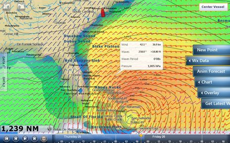
I first learned about Hurricane Sandy in an interesting way. While enjoying sunset in the Calabash River anchorage a week ago today, I was also fooling with various WiFi features built into a just-installed Furuno NavNet TZT14. Actually I was trouble shooting the seemingly flaky WiFi connection when I discovered that the TZT could connect to my Android phone’s WiFi hotspot and even use that connection to quickly download a GRIB weather file. I’ve never seen an MFD do that before! Then I was admiring the TZT’s neat controls for viewing the GRIB predictions — like the intuitive way you can slide your finger along the forecast time bar seen at the screen’s bottom — when I noticed the tropical cyclone headed my way! But I lucked out; Sandy just slapped the Fort Lauderdale boat show around a bit, and now I’m aboard Gizmo is in a hurricane hole that’s below the immense storm anyway. Today I’ll be thinking particularly about other cruisers who didn’t get this far south already, but I do have time to describe how Furuno is trying to do MFD WiFi different…
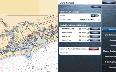
First of all, the TZTouch is so far the only WiFi MFD that can be more than a direct access point which onboard mobile devices use to run control and viewing apps; it can alternately join an existing onboard WiFi network so you can run other apps and even be online all with the same AP. Thus the easy weather download through my phone. And thus you won’t find a menu like the one below on a Raymarine e- or c-Series or on the software update that will enable Navico’s GoFree WiFi1. So if you’re, say, running Raymarine’s RayControl on an iPad and you want to use the app that can control a Fusion 700 Series A/V system that’s wired by Ethernet to your boat’s WiFi router, you’ll have to go into the iPad’s WiFi setup and change access points.
Truth be told, though, I have not yet gotten my iPad to connect directly to the TZT. Furuno acknowledges problems, gave me some tips I’ll try later today, and promises improvements in TZT 2.0 software coming out soon. In fact, when my the TZT 14 was online via phone last week, a dialog box popped asking me if I’d like to download an update (though that was apparently just a test and I didn’t dare say yes anyway). The TZT has also declined to join my M/V Gizmo onboard WiFi router network so far, but I did get a peek at Furuno’s unique NavNet Viewer app via the phone…
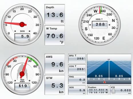
What’s unique is that what’s on the Viewer screen is completely independent of what’s on the TZT screen. In other words, it’s the app itself that creates the gauges below from data supplied by the TZT. It’s a good example of what should be possible with Navico GoFree tier one and two data (i.e. data that came to the MFD via NMEA 0183 and 2000) and hence I suppose Furuno could open TZT to third party developers if they feel like it.
It’s noteworthy, though, that NavNet Viewer can also show a stream of fishfinder imagery if you have a Furuno fishfinder in the system (I don’t). And building custom screens like the one below is dead simple. There’s also a NavNet Remote app like Raymarine’s and Navico’s. But let’s have a look at why an independent viewer app has value…
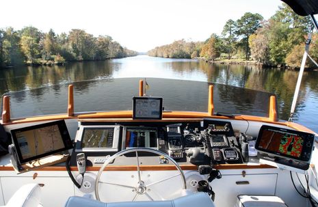
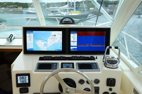
TA TA! Here’s a look at the latest and grandest iteration of Gizmo’s flying bridge test set up. Aside from the TZT I’ve just put a lot of miles on all that gear and the systems below; they definitely made the trip easier and I’ve got lots to say about things I like or would like to see improved before I take the boat north again in a few months (after installing more stuff!).
But here’s the more specific purpose of the photo: It’s great that I can use RayControl or NavNet Remote to fully duplicate the functionality of those respective MFDs elsewhere on the boat, but the beauty of NavNet Viewer is how I can use right alongside the TZT. It’s amazing how many ways WiFi (and Bluetooth) are going to expand marine systems, but I’m also realizing that making WiFi work well with marine Ethernet networks is not as easy as we might presume.





Ben, downloading and displaying gribs is a big feature for sailors (and other boats, I imagine). Do you think that Navico will do something like this? I for one would LOVE this feature.
Chris
Is there a POD mount for the TZT ( ie sailboat helm)?
Very cool tech here. This is the future of NAV.
Ben, I see you’re following rule 7, and using the maximum amount of “aids to navigation” allowable by law. If all of that gear is on at night, even in night mode, is it too bright?
Hey Ben,
Great seeing you in Lauderdale. Awesome helm layout on the bridge. I’d love to see you throw one of the EMU-1 Actisense Analog to Digital Engine data converters, unless those TAMD74s are outputting J1939. You’d be able to drop that into the N2K network and view that data on pretty much any of the MFDs as well as a few of the instruments you have, not to mention the iPad.
Getting to the topic, I love the GRIB viewer within TZT as well. The whole interface of the system is striking similar to what has been achieved through the MaxSea/Nobeltec TimeZero software suites, and the GRIB viewer along with the ability to overlay the standard tides and currents and animate is great. It’s funny, over breakfast with Brice Pryszo, the man who founded MaxSea back in ’85 and has been using nothing but a Mac/PC for over years, told me how he felt so comfortable with the TZTouch interface, that he found himself actually plotting using the MFD as opposed to the PC next to him on a test run. I personally love the combination of the TimeZero SW when it comes to plotting an analyzing route data in conjunction with the MFD, and most of our clients have that configuration. The touch interface is very intuitive, as you’ll realize, and the new software provides even more options from the tap of a finger, with the ability to view the entire RotoKey menu without having to press any additional button, including locking a FLIR camera onto a particular target. Very nicely done, I think you’ll have fun with that TZT.
PS: Make sure when you’re connecting the iPad to the TZT, use CAPS for everything. I ran into a problem when I first tried it out of the box, and once I reread the instructions, I noticed it mentioned that. I hope that’s the only problem. I used a first generation iPad, and both the Viewer and Remote app worked flawlessly. In Lauderdale, I’m sure you saw the new beta software for the Remote App, looking forward to seeing that in action as well.
Hi Ben
Another great feature of the Navnet Viewer app is the ability to duplicate alarms from the TZT via wifi.
The app needs to be running or it will not work (however this is an apple short coming not a Furuno one) but means you can have your iPhone or iPad on next to you in your cabin and if for example, an anchor watch alarm goes off it will alarm on your ithing as well.
Furuno have done an excellent job of covering what 95% of boaters would require in an app, right out of the box.
And as Labozza said, make sure your password is in CAPS. You may need to change your password on your ships wifi to caps, but once the TZT is on your ships wifi, thats it! no changing wifi networks on your ipad! and you can keep up dating your GRIB files to your hearts content.
Checkout the below link showing sea surface temperature band between 67-74’F
https://www.facebook.com/ElectronicNavigationLtd?ref=stream
Ben,
TZTouch’s WiFi sounds cool – but for all of those who have (recently) invested heavily in Navnet3D, and/or MaxSea Time Zero the obvious question is – When will we see backwards compatability for these systems, in terms of the WiFi and remote app features?
Or will these folks be left out, the same way Simrad owners were, as talked about in a recent post last week…..
Don’t mean to hijack the thread but I’ve watched the video of the USCG rescuing 14 Bounty crew twice now and think any boater who hasn’t seen it should:
http://www.youtube.com/watch?v=UDlc1slA8PA
And if you want a way to thank the USCG for what they do, I know the place.
http://www.coastguardfoundation.org/
Ben, impressive USCG work under odious conditions. Most sobering. It does beg the question, “What in the world were they doing out there in the first place?”
“The Bounty is currently classed as a dockside attraction which is a classification not a statement on her seaworthiness.”
http://easternyachts.com/bounty/specifications.htm
Bill, There’s some discussion of the decision to leave CT last Thursday on the Bounty’s FB page, in posts before the disaster:
https://www.facebook.com/HMSBounty
I always try very hard to reserve judgement in situations like this, but my sense is that a paying gig in St. Petersburg starting 11/10 had a lot to do with this.
Ben, the facebook page is down due to traffic. I wasn’t being flippant, it was tragic, but they ran right smack into Sandy on its west side. The position fix on the storm Monday morning put it slightly north of Cape Hatteras. They would have been on the west side of the storm running south in 30′ following seas, and very high winds. Shelter could have been had on Sunday while the storm was still to their south. I dunno, it had to be a deliberate decision to try to weather through it. According to some news reports they were trying to steer clear of the storm. I don’t see how they could have unless they went into a safe harbor.
I experimented with TZT WiFi some more and found that if I removed the TZT14’s password I could connect directly to it with both the NavNet Viewer and NavNet Remote apps running on either iPad1 or iPad3. NavNet Viewer worked well, but Remote can be laggy especially if you try the highest of the three resolution settings (which, of course, is what you’d like).
This makes chart work particularly difficult as the RotoKey zoom function is missing from the Control app. You can immediately see what your finger zooms and pans are doing are on the TZT screen but the results are delayed on the iPad screen. Also, on the iPad1, the Remote app runs upside down! I know that Furuno is working on all this, but again I say that this WiFi thing is not easy!
News that the Bounty sinking will be investigated and that some tall ship captains have expressed surprise that she left harbor on 10/25: http://goo.gl/4pAAH
Also turns out that the vessel was in my neighborhood this summer and Captain Walbridge gave a long interview that’s on YouTube: http://goo.gl/Ogbov