C-Map fishing charts, all but the bait

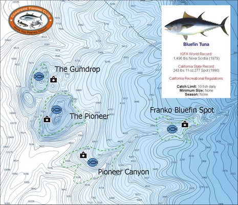
Yesterday another reader emailed, “What’s new is the fishing electronics world? It is Spring time, and we just had the salmon opener here in San Francisco!” Well, how about a C–Map MAX Coastside Fishing Club chart card full of hi res bathymetry and other goodies useful for fishing from Pt. Conception, California, to Coos Bay, Oregon? Actually I’m a little confused by the press release’s mention of “exclusive Member’s Only fishing data like IGFA and state record information, local fishing regulations and favorite fishing spots of club members.” C-Map’s catalog seems to indicate that the card is available to anyone, the Coastside Fishing Club makes no mention of it, and, besides, it seems pretty similar to C-Map’s other Max Fish Bathy cards (see 2/06 press release). Maybe someone can straighten this out?
And, if you go way off San Francisco, keep an eye out for the unusual radar semi-submersible SBX-1, spotted with an AIS receiver setup that’s purportedly seen targets 1000 miles away.
PS 4/12: It turns out that this card is available to the public, but what most distinguishes it from the Max Fish card covering the same area is the inclusion of hot spots provided by the Club. Thank you Coastside!


