WiFi MFD’s, Navico GoFree promises more than met
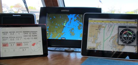 After Raymarine and Furuno introduced multifunction displays with WiFi built-in and apps that could mirror and even control the MFD screen on an iPad or Android tablet — a great idea that caught on quickly — I was frankly a dite dubious when various Navico folks said that they had an even better idea. Eventually, though, we got to discuss the WiFi1, their MFD network hotspot, and then the whole multi-tier GoFree concept. It’s a complicated concept largely because it’s so ambitious — for instance, supporting both Navico screen control apps and multiple third party apps like the ones seen above — but it seems to me that GoFree is now doing even more than Navico promised, and there’s virtually no limit to where it’s headed…
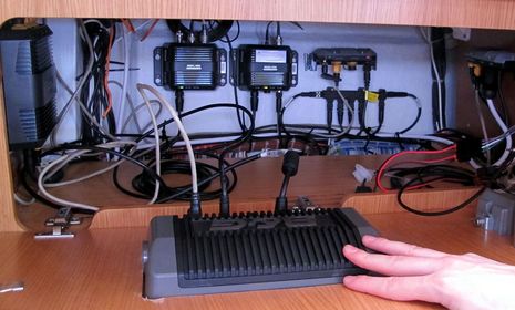 The photo above shows a GoFree WiFi-1 module (upper right) that had just been installed for the B&G press event in Las Palmas last February. I was easily able to view and control the Zeus Touch goodness with my iPad mini using the B&G/Simrad/Lowrance GoFree app (Las Palmas screenshot here) and also had success streaming GoFree “NMEA 0183” data into several third party apps. Getting Gizmo’s fairly complex Simrad network to work well with a WiFi-1 took me a while (and various updates I misunderstood at first), but it’s been solid for months now and I’ll discuss some results below.
But let’s note first that some people want GoFree to work with their own boat’s WiFi routers, no WiFi-1 involved, and though Navico made no promises, they’ve apparently satisfied that desire by publishing details about how to do it (see the download section down the product page). I say “apparently” because I haven’t tried it (and am not sure I have the IT skills required), but some Panbo readers report success.
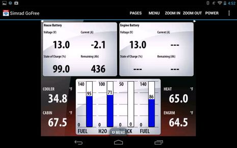 Navico also came through with the Android version of their GoFree app, as seen on my Nexus phone above. I don’t think that it makes as efficient use of the screen space as the iOS version does (please stack the controls right or left if possible), but it’s fabulous that I can monitor Gizmo’s tank gauges while fueling from a dock or running the overboard waste pump inconveniently installed in the head (happy CZone tank interface story here). Plus, I can use an iPad to bring the NSS 8 up to the flybridge alongside the NSE 12 (though the vice versa is not possible because the NSE doesn’t have the video chip needed to enable the screen streaming app).
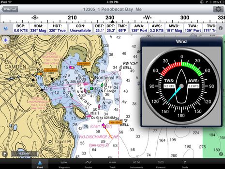 Then there’s what Navico calls “Tier 1: TCP/IP NMEA 0183” data. I didn’t expect much when I first put the WiFi-1 IP address into the iNavX iOS nav app — because Gizmo’s NSS 8 has no NMEA 0183 data going into it — but, wow, iNavX gets GPS, Wind, Depth, Heading, AIS, and more. And, thus, is a much more full-bodied nav program than it already was. The impressive SEAiq app provides similar GoFree nav integration at a much lower price (though the AIS streaming needs some work).
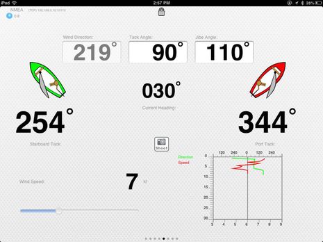 So, Navico is generously translating a lot of Gizmo’s fundamental NMEA 2000 data into an 0183 format that’s easily understood by many third party apps. The iRegatta iPhone/iPad tactical sailing app, for instance, seems fully populated with Gizmo GoFree data and a good example of how the integration can make some tricky niche functions fairly easy and inexpensive to obtain.
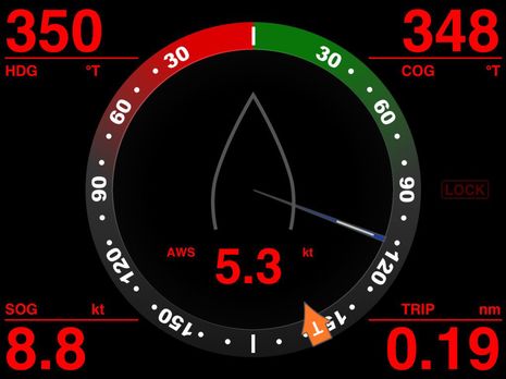 MID Wifi seems to provide some iRegatta performance specifics like polars while also offering sexy instrumention that looks ironically similar to Zeus Touch (though you may want it on a pad so you can devote your Zeus screen to charts, radar, etc.).
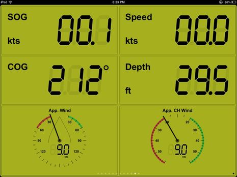 I’ve just started testing NMEAremote, but I’m already convinced that there’s a very talented programmer behind the scenes. Its goal is boat instrumentation any way you like it, and it’s slick how all the possibilities are organized into themes and chapters (though I wish there were alternates to the faux segmented LCD data font).
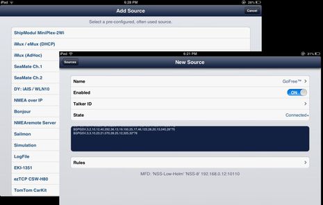 What’s especially interesting is how well NMEAremote handles the WiFi data connections, and how many flavors it can support. While iRegatta even makes you dig into iOS general settings to set up your GoFree IP address, NMEAremote is the only app I’ve seen able to figure that out itself. Note how it also has a data stream window so you know immediately if the connection is working and that Rules button lets you control individual data type inputs.
I’ve heard that NMEAremote will also be the first to support the super easy Bonjour WiFi interface built into the Vesper Marine WiFi AIS transponders — Vesper Vision is already working well with third party apps on Gizmo (more to come) — and do check out that list of supported NMEA sources. In fact, you do not have to own a current Navico MFD to use any of these apps. It’s more like Navico has helped its customers (and itself) by freeing its system data for use with third party apps, and I bet that’s helping not only those developers but even the various manufacturers who offer alternative hardware to get NMEA data onto WiFi. A lot of boaters don’t know about this NMEA WiFi thing yet.
 Of course, it would be great to hear how others are using GoFree, but a couple of other points first. Something I don’t understand is the state of Tier 2 NMEA 2000 data. Obviously, the generous 0183 feed takes care of many needs and is being widely adopted by the apps developers, but Tier 2 promises to unleash more info than 0183 can handle, plus two-way control. Do any such apps exist yet, or are about to?
Let’s also note that neither Navico, Raymarine, nor Furuno yet have an associated planning app that passes routes as neatly as Garmin BlueChart Mobile does (though Nobeltec/MaxSea TimeZero could conceivably get that feature at any moment). Meanwhile Garmin does offer a screen control app, and none of the MFD manufacturers beside Navico is working with the independent developers. Finally, Standard Horizon just entered the game with a CPN software release that supports screen control integration with C-Map Plan2Nav (and purportedly brings numerous other improvements, including N2K support, to that still-trailblazing WiFi plotter).
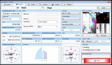
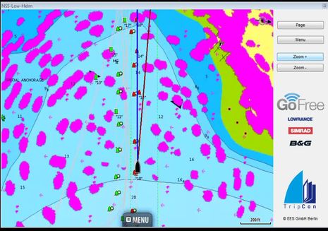
But what about the upper tiers of Navico GoFree, about which very little was promised? This weekend I had the pleasure of trying TripCon Lite, the free trial version of an unusual logbook PC program being developed in Germany. It took just a few minutes to install it and select Gizmo’s GoFree WiFi as the data source. As illustrated above and below, TripCon not only uses the data streaming seen in other apps, but also NSS 8 screen streaming and control. I’m hoping to test the full version, but it sure looks like I’ll be able to record the video screen or attach screenshots to an automated or manual log entry. Like I said, the GoFree possibilities seem unlimited.




Ben
Re your statement that
“Let’s also note that neither Navico, Raymarine, nor Furuno yet have an associated planning app that passes routes as neatly as Garmin BlueChart Mobile does (though Nobeltec/MaxSea TimeZero could conceivably get that feature at any moment)”
Whilst it is not a Raymarine app – Raymarine market the ability to sync routes with the Navionics app with their new e and c series MFD’s as per their website
“Sync With Navionics Mobile
Instantly synchronize waypoint locations, favorite fishing spots and route plans between the new e Series displays and the Navionics Mobile app. Plan your next voyage on your iPhone or iPad and then wirelessly sync your route plans using the new e’s built in Wi-Fi. Just go to the Apple iTunes App store and download the Navionics Mobile app”
I use the Navionics app and find it very user friendly – Have you had the chance to test Raymarine’s marketing statement around syncing with their new e and c series MFD’s?
Cheers Dave
Very smart approach here by Navico. Exposing system data and control with ubiquitously available Internet protocol based methods. Enabling third party application innovation while also controlling the GoFree ecosystem via the tiered approach. Nice.
And the WiFi-1 runs on 12v 😉
One of the shortcomings of the Simrad NSE system (and I think all Navico MFDs) is the inability to track cumulative fuel use. My analogue fuel gauge is so imprecise as to be totally useless underway. The fuel shifts in the tank too much from running attitude changes, except of course at the only point one does not need it, which is when completely full. This is so common from my experience as to be the norm for planing powerboats.
I had a Garmin GMI-10 on my old boat that displayed and stored the fuel rate data off the NMEA 2000 network and showed very precise “fuel remaining” if I had input the starting volume. When I refilled, it was accurate within 1%. My Simrad NSE and IS40 cannot do anything like this, though purportedly it can be done with a Lowrance EP85R storage device on the network. I say “purportedly” because this device cannot be calibrated with an NSE, only Lowrance devices and is thus useless even though a SImrad tech told me it would do the job.
What would be nice is to have a little app on my iPad that could take the fuel rate data off the network via WiFi and track it. Do any of the nav apps do this?
Dave, I did try Navionics “Plotter Sync” when I first got a Raymarine e7 a couple of years ago and my memory is that it worked, but not like the Garmin “Activate Route” function which not only transfers a route but also activates it across the boat’s Garmin network with just three taps on the iPad and one on the receiving Garmin MFD.
But you’re right that I should try it again, especially now that I have two Ray MFDs networked on the boat and Navionics has much improved their app route building. They also just introduced auto routing as another in-app purchase.
Quitsa, that sounds like something that Simrad could fix on the NSE, but I fear that N2K fuel flow and engine data are still so uncommon that they don’t get much attention. If there is an app that could help you it might be from Chetco or able to work with their SeaSmart.net, as Chetco has focused on engine data:
http://www.seasmart.net/
I am on my third NSS12 – the first two being defective. I also have the Go-Free which is very nice. However I was told by Navico the the 2.5 update was “crap” and to unload it. A 3.o version is on the way, I was told. I can’t say I am at all happy with the NSS12 over all. The charts are very poor, IMHO. I’m hoping the new update – when it arrives – will make them look like real charts.
Say what? I’ve been running NSS Software 2.5 for months without any issues and I’m dead sure that Navico does not have a policy of calling it ‘crap’ and recommending a reversion to earlier software. Who told you that and what were the reasons given? 2.5, incidentally, is still very much available:
http://www.simrad-yachting.com/en-US/Support/Downloads/NSS-Software-2-5/
Can I presume that the charts you’re talking about are the Insight U.S. charts that come preloaded? I’m not crazy about them either, but they have gotten better looking as the software is revised and I noticed that they seem to better in the middle Atlantic states than they do up here. The NSS and NSE can also display all sorts of Navionics charts well, and can now display NV Charts raster charts (samples work great) and C-Map Max-N charts (have tried yet).
Also, have you tried using the many adjustment for detail and specific data types shown that are available for Insight charts on your NSS? I can’t recall exactly what I did, but I know I got them to be more useful to my eyes.
My quote is direct. The person at Navionics was a supervisor. Has anyone heard of the 3.0 update?
My gripe with the Insight charts is they look like and Iowa cornfield from the air and show nothing like any chart I’m familiar with. I’ve tweaked as best I can and have yet to see anything very helpful.
I wonder why they can’t use regular charts – regular as in paper charts that are familiar! Perhaps I need to spend yet more money with Navionics and buy upgraded charts. I’m not sure what you mean about the NV Charts raster.
Yes, Navico (not Navionics) has been talking about RTM 3 since at least last October (in regard to to GoFree: http://goo.gl/2aXLqU ), when the release date was some time in 2013. There will probably be future versions 3.5, 4.0, etc. So it goes.
Raster charts like those made by NV Charts are scans of paper charts. Unlike vector charts they can not be changed in any way on a plotter screen (which has pluses and minuses). They require a lot of processor horsepower to display because they are like large photo files while vector charts are databases that are used to assemble a screen image. That’s why earlier chart plotters almost invariably used vector charts.
Amongst current chart plotters the Furuno NavNet series was the first to offer raster display, but just recently Lowrance/Simrad/B&G have followed suit. So you are probably one of the few people in your harbor who can use paper-like electronic charts. Which you can get here:
http://us.nvcharts.com/index.php?page=categorie&cat=25
The TripCon software looks very interesting to me. I installed the free Lite version of their product, but could not make the GoFree data connection work. If I selected NMEA over TCP/IP, while connected to the GoFree router, it would process the NMEA data – so clearly there is some connection going on. Of course this would mainly be worth the cost of purchase if I can get the full abilities of the GoFree connection, including view and control of the NSS8 in the system.
Anybody else have any luck with this? Ben clearly got it working. Not sure what I could be doing wrong. I sent the developer an email, but no response yet.
Hi Greg,
Selecting GoFree could be more obvious (and may have been fixed with an update TripCon poster yesterday). You need to click on the blue bar at the top of that NMEA dialog box and then you’ll get a drop-down menu that includes a GoFree selection. I just emailed you a screenshot.
Thanks for the reply Ben, though I did not see your screenshot. I am guessing they did change the selection procedure, because I see the file I downloaded was dated yesterday (8/22/13) and I did not have any problem selecting GoFree – it just doesn’t work. Perhaps whatever change they made yesterday fixed the ease of selection, but broke the possibility of it actually working.
What I would love to have is a PC version of the IOS/Android app that allows for remote viewing and control of an NSS display. I have a dedicated PC at my vav station down below that I have OpenCPN running on. It would be most excellent if I could view the radar on this same monitor. It seems that TripCon does this while at the same time adding a neat boat log functionality – however this come at a fairly steep price (assuming it even works).
Anyone working on a basic PC viewer/controller?
I too would like this. TripCon has a version “TripCon – MFD” which is a standalone program focused on GoFree control and has basic functions of their logbook software. This sells for EUR 199. The other option for GoFree is an add-on to their main software where the total package is considerably more expensive.
I have emailed them if it also works with a regular wireless router or requires a Wifi-1. The website does not clearly say this. Can this be tested with the freely downloadable test version? Ben have you tried it that way? I also asked them that question but don’t have an answer yet.
Information from TripCon: the Wifi 1 is required for TripCon MFD to work. I don’t really mind the cost of a Wifi 1 but I need a fully configurable wireless router, e.g. allowing me to set preassigned addresses for specific MAC addresses, and I need a router also supporting a UMTS/3G USB modem and which also allows to alternatively set a different default gateway, e.g. a Ubiquity bullet/Rogue Wave. I have found all this in the TP-Link TL-MR3220 and so could only use a Wifi 1 if it could coexist with that router. But then I certainly don’t want to connect my PC via WLAN if a cabled connection is easy to do as in my case.
So it seems that this rules out TripCon MFD for me.
No information on whether this function can be tested with the trial version.
Hi there,
I’m from EES/TripCon in Berlin. It is nice to see that TripCon-MFD can be an interesting product for you. For testing please use the actual release of TripCon from Aug 22th which you can download here http://www.tripcon.de/en/repository/tripcon-lite_en .
With this version you can test the connectivity with your MFD using the GoFree WiFi connection. The features of the Lite and the MFD Version you can compare at the Webpage too, see http://www.tripcon.de/en/tripcon-mfd .
If there are questions/problems please contact us. Your questions will be answered between 9 am-5 pm Berlin time on working days.
Plaudits to SEAiq’s Mark Hayden! When he saw my remark above about AIS issues with GoFree — which I should have told him about — he got me to send an email from the app, which includes a NMEA data sample if hooked up. Then he fixed his code in a few hours, put me in his Beta program to test it, and I can testify that the next release of SEAiq will display GoFree AIS data fine.
Thanks also to TripCon’s Uwe Lang, who also read this entry and then sent me unlock codes so I give his software a workout. I’m looking forward to it.
I wanted to report that the programmers at TripCon just sent me an update to their product that now allows it to work on my XP computer. That was my problem earlier – running XP. It now seems to work fine. That said, when I look closely at their pricing, it is hard to justify spending 199 euro ($263 USD)for this program, when all I really want is the functionality of viewing and controlling my NSS8 from my nav station computer. This is particularly hard to swallow when Navico offers their Android App for free, which does exactly this. It sure would be nice if Navico came out with a PC .exe version of their app, or run it as a web page.
3.0 software is available as of today. I have been running a beta for a few weeks and it is a really good improvement over 2.5, both stability and features. 2.5 would cause my NSS12 to reboot after a few hours of use. No issue with 2.0 or 3.0.
Thanks, Stiletto! There are lots of interesting new features in NSS 3.0, like support for the OP40 keypad. That will bring the NSE things I miss, like direct function keys, to NSS. Also FusionLink over N2K, FLIR camera integration, lots of chart compatibility and feature improvements, & more. See addendum at bottom of download page:
http://www.simrad-yachting.com/en-US/Support/Downloads/NSS-Software-Update/
Hi Ben,
Love he site, was wondering what you knew about the promised Plotter Sync capacity of Navionics iPad app with the Simrad MFDs? As promised here:
http://www.navionics.com/en/navipedia/press-release-navionics-announces-expanded-chart-availability-and-connectivity-lowrance
I’m considering a major conversion to Simrad, but want to be able to plan a route on my computer or iPad and transfer it over wifi or Bluetooth to the MFD. So ft I haven’t seen anything like Furuno and Nobeltec or Garmin and Blue chart.
Thanks!
Hey Ben,
In your article you said,
“But let’s note first that some people want GoFree to work with their own boat’s WiFi routers, no WiFi-1 involved, and though Navico made no promises, they’ve apparently satisfied that desire by publishing details about how to do it (see the download section down the product page). I say “apparently” because I haven’t tried it (and am not sure I have the IT skills required), but some Panbo readers report success.”
I have been swapping emails with Phil at Navico Support on this, and I was told that it is NOT possible to set up a GoFree network so that mobile devices that connect to the GoFree WiFi can also access the Internet via another router connected to the GoFree network.
It’s a real shame, because it means you have to choose between connecting your mobile device EITHER to Navico’s self-contained GoFree network OR to the Internet, but NOT BOTH. If you ever get the ear of someone at Navico again, it might be worth dropping the not-so-subtle hint that a self-contained, non-Internet-connected WiFi network isn’t much use these days.
“that mobile devices that connect to the GoFree WiFi can also access the Internet via *another* router connected to the GoFree network”
For user devices (not servers) it’s rarely a good idea to connect to two networks at the same time. Doing this would require the routing table set up just so to get the connectivity you want (the routing table tells a device which network to use to get to which IP address, like “go left to the Navico MFD and right to the internet”). I don’t think my Android devices even allow to connect to two WLANs simultaneously. I certainly don’t know how to edit the routing table on it. When you connect to a new network, you automatically disconnect from the old one.
I have never owned a WiFi 1. I have just cut off the yellow Ethernet connector on the other end of the network cable from my NSS7 and put a standard RJ45 connector on it using Kees’ instructions at http://yachtelectronics.blogspot.de/2010/05/lowrance-yellow-ethernet-cabling.html This connects my Navico device to a standard household router (currently a dovado pro, before that a TP-Link TL-MR3220 and before that a Netgear MBRN3000) and that was it. My navigation PC has a wired Ethernet connection to the router and all other PCs, tablets and phones use a wireless connection.
I can use the GoFree app on my android tablet and phone and I have accessed the GoFree NMEA0183 stream using the test version of Tripcon http://www.tricon.de on the Win7 PC. I can even view and manipulate the Navico radar image using OpenCPN on the PC.
The router connects to the internet using either a Wave WiFi Rogue Pro or a USB 3G/4G modem.
You should be fine if you just dispense with the WiFi 1.
It is possible to connect two WiFi-1 units on the same network, and have one connect to the internet and the other to your IPad / Android. To do this set one WiFi-1 in secondary mode then connect the second WiFi-1. You can then set that to client mode to connect to the internet.
Hi,
can’t I connect an external Wifi/Antenna combo via Ethernet (with RJ45 to SimNet Ethernet cabling) to one of the GoFree ports and use it as router. That way connecting my iPad and MFD to the internet and still have the iPad connected to the MFD as originally intended?
Klaus.
Hi Klaus,
Yes you can — that is what I do on board my boat. I have COTS wifi and wifi router, with a normal Ethernet switch with all the Navico products connected up as well. This works fine and gives me a single on board WiFi network with GoFree access to the MFD and internet access. In fact it also gives the MFD internet access for chart and software updates.
I have a Vulcan 7FS with built in wifi (Go Free) and when it works the Navico Go Free app on my ipad is fantastic. Mirroring my Vulcan screen on the ipad is great and controlling it to is very nice but I am having no success getting my NMEA data to any other app – MID Wifi iNavx etc.
Any pointers would be much appreciated.
I plan to call B&G support but unfortunately cell service at our community marina is patcht and wifi reception is worse so I am not optimistic about the possinilities of remote diagnosis.
Thanks
Patrick
To get the NMEA data to work, make sure you add the port 10110 to the IP address you are pointing to i.e. 192.168.0.xxx:10110. I get the data to show up on my OpenCPN with no problem.
Greg Davids
I did not do anything except run a cable from our Cisco wireless router to the B&G WIFI-1 wireless router.
Automagically, any iPad connected to our wireless network gets actual boat depth data. For example, Navionics on the iPad starts re-drawing the bottom (Sonarcharts) underneath any bottom we have passed.
The only problem I have is that if I turn on the radar, the Cisco wireless network dies.
Cheerio,
In my experience, Navionics Boating will see boat Depth (and make/show SonarChart Live) with a direct WiFi connection to WiFi-1 (and no radar problem). But it’s an unusual app in that regard. Most, like the ones Patrick mentioned I’m pretty sure, need to be told the IP address and port where they’ll find the data stream, as Greg described.
The difference seems to be auto discovery, also called Bonjour in iOS world. It’s nice when it works well, but I’ve seen cases where it didn’t work if the data is streaming through an intermediary router.
Thanks Greg, Xavier and Ben – sorry I wasn’t signed in when I asked the question above.
Mirroring my Vulcan is now more stable since I updated the MFD to the latest software but I am still having trouble getting NMEA data to any other app.
I have set the port to 10110, tried TCP and UDP and tried using the IP address of the Vulcan as well as 255.255.255.255 as suggested by MID Wifi.
I have not yet tried Navionics Boating but will do that as soon as this nasty weather passes – hopefully before the nastier weather forecast for Monday night!
Thanks Ben – Navionics Boating does indeed show depth. Still no luck with any other apps but it was 26 here this morning and no heat on the boat so I didn’t spend long fiddling.
Now working with most apps -TCP port 10110 and my Vulcan ip address 192.168.76.1.
I thought I had all that entered before but evidently not!
Slightly off topic my old P79 in hull depth transducer from my retired Standard Horizon speed/depth instrument now plays nicely witht the Vulcan as a back up, or when I don’t want water in the bilge from installing the DST800. It is a pity Navico don’t seem to make a 9 pin bare wire pigtail so it needed a phono plug attached to the 7 pin pigtail and then a 7 to 9 pin adapter. I guess I could have just cut the 7 to 9 pin adapter and attached it directly to the phone plug or jus spliced the wires but this seems more adaptable in future.
Can I hook up a wireless Router to my Raymarine A78 that does not have wifi and get access to the screens remotely?
I don’t think so, Robert, though Ray’s WiFi has gotten pretty sophisticated:
https://panbo.com/archives/2016/09/testing_raymarine_quantum_q24_radar_solid_on_many_levels.html
But I suggest that you ask on the Raymarine support forum:
http://forum.raymarine.com/
I see that the TC-MFD-Control is no longer available on your website for purchase. Is it still available and will it reliably work if purchased from http://www.kirschnek.at/cms/index.php/seefahrt/segelshop/product/view/2/4
I have a complete Lowrance package:
Outboard Cable Steer
4G Radar
HDS7 Gen3
MotorGuide Xi5 60″ 36v Saltwater
Link 8 DSC VHF
I’m finding it a very difficult pill to swallow that I can’t control or switch my auto pilots off and on and select active auto pilots go to cursor power steer or anything else related to my auto pilots after such an investment. Just a big ugly padlock is what I get for my money.
It is akin to finding out I needed one last $200.00 dollar cable to hook my trolling motor up to the network. Now having done that I need to spend another $1000.00 dollars so I can actually control my autopilots from inside?
Please tell me the link above still works and I can bleed out a little more funds for the application that allows me to control my MFD properly.
Arden, TripCon-Complete includes the Lowrance/Simrad/B&G integration:
https://www.tripcon.de/en/tripcon-complete
But I don’t understand what that has to do with piloting your MotorGuide Xi5. Your Lowrance HDS can definitely do that very well once set up with the Gateway Kit:
http://www.motorguide.com/pinpoint-lowrance-gateway