
The new MarineTraffic Internet AIS service, cautiously optimistic
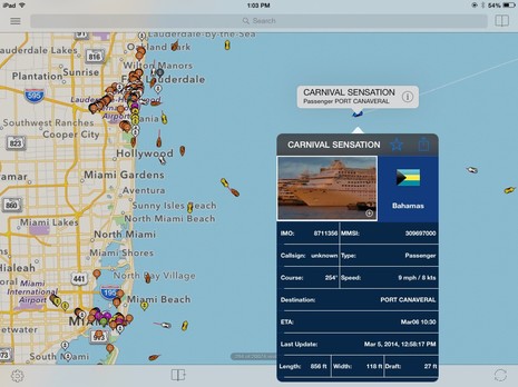
These days I feel obliged to include a warning every time I write about AIS over the Internet. What you see in a nice app like ShipFinder HD (above) probably does not include every vessel that’s transmitting AIS info even in fairly well covered areas like the Miami/Lauderdale area, and many areas aren’t covered at all…unless perhaps you’re using the Seapilot app in Sweden or somehow have access to another well-organized AIS receiver system. That’s because what most of us see on computers, phones or tablets connected to the web is target data collected by patchy networks of volunteers, whose shore antennas may well miss even fairly nearby 2 Watt Class B AIS transmissions or even 12 Watt Class A signals obscured by buildings or terrain (or may suddenly go offline just because the volunteer’s kid trips on a power cord or something similar).
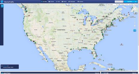
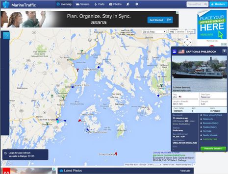
That warning stated, one particular source of Internet AIS, MarineTraffic, seems to have attracted a large number of volunteer listening stations. The screen above shows all the stations currently registered in the USA — a lot more than there used to be — with the color green representing the ones that were sharing live data this morning. MarineTraffic (MT) is even stronger in Europe, and thus, the bottom left brag about having 56,026 AIS targets in range when I grabbed the screen. Note also how MT vastly improved its web browser presentation recently, though that change came with a possible problem.
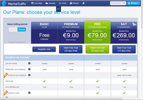
Along with a completely redesigned web interface and a slew of new features, MarineTraffic became a commercial AIS tracking operation, and I’ve unhappily experienced that transition before. Back in 2005, I lamented the limitations of AISlive once it went seriously commercial, and something similar happened to the VesselTracker site that was a favorite in 2008 (along with several still-good regional services). In recent years MarineTraffic seemed to build the best global coverage with the most user features among the free sites, but will a hunger for subscription revenues mean decreased AIS tracking for freeloaders like me?
Well, so far so good, and I like the “Free Forever” notation on the Basic membership in the various service plans partly shown above. The plan list is also a good place to see all the features MarineTraffic offers now, including satellite tracking of vessels beyond shore stations. And about the only new limitations for Free users that I can detect are a limit of 5 vessels in “My Fleet” and only three days of vessel track history. Those features remain pretty useful in my view, and I particularly like being able to tag Fleet vessels so I get emailed when they enter or leave a port, as noted in this 2012 MarineTraffic appreciation. My Fleet combined with the still free MT map widget also makes a nice addition to Panbo’s About page (and might work well for many marina and boatyard sites).
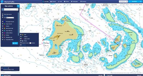
Notice that my own My Fleet isn’t limited to 5 vessels of interest and that my screenshots aren’t showing the ads that appear if you’re on the Free plan or unregistered altogether. That’s because MT gave free Premium subscriptions to all its volunteer station keepers when the plans were introduced, and I was maintaining a receiver here in Camden (as I wrote about here). That was a nice gesture (and I hope to get a station running on Gizmo before MT pulls the subscription). It’s neat, for instance, to zoom into targets on a high quality (Jeppesen C-Map) nautical chart anywhere in the world.
The example above shows a yacht working its way into an exotic looking anchorage in the Tobago Cays today — an inspiring sight from a desk in chilly Maine — though its Class B signal is barely being captured by a volunteer station on Carriacou. And that’s why it’s great the MarineTraffic is offering free Pro or Premium plans to new volunteer stations (depending on performance) and even offer free receivers for good locations.
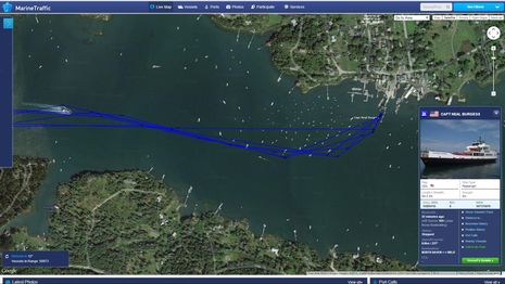
There really can’t be too many AIS receiving stations in my experience, and I continue to think that it’s a great opportunity for marinas and other coastwise marine businesses to “add a little value” and do a little marketing at low cost. In fact, one reason I’ve been lax with my home station is that Wayfarer Marine set up a reliable station in Camden Harbor, and the inhouse installer Alden Cole enjoys maintaining a volunteer station so much he also minds a home system high in the hills behind town. There’s another station at the Lyman Morse boatyard in Thomaston — note the credit in the target detail box above (that’s the marketing part) — and Walter Barnard’s station recently opened in the north bay. Walter’s rig is down today, but note that he’s also been taking photos of local AIS targets like the ferry shown above, and photos are a huge part of Internet AIS (and can also earn free MT subscriptions). And finally, a new station just popped up in Searsport, but they haven’t yet identified themselves on their MT account’s My Stations page. (This screen also shows where the ads go if you’re not logged into a pro subscription).
At any rate, it looks like the east side of Penobscot Bay will be well covered on MarineTraffic when spring arrives and lots more boats finally appear. It’s likely then that even a small boat sailing around North Haven will be able to know when the ferry will loom out of the fog, with just a smartphone and an inexpensive app like MarineTraffic’s own. If the existing stations stay alive, even more elaborate Internet AIS focused apps like the SeaNav/BoatBeacon combo should work well around here. Plus, Wayfarer and Lyman Morse (anyone really) can put up MT widgets so their customers with AIS, or their families, can see what’s going on from afar. They can even suggest the mAIS app so boaters can get on MT, even if they don’t have a real AIS transponder.
But not far in either direction, and in many other places around the US coast, there’s still no Internet AIS coverage at all. If you have a spot and a few hundred dollars to invest, please consider becoming a MarineTraffic volunteer. I also think all us volunteers should hedge our bets and promote competition by contributing our feeds to other sites like AISHub, ShipFinder, and FleetMon (I’ll add details to the “how-to” entry).
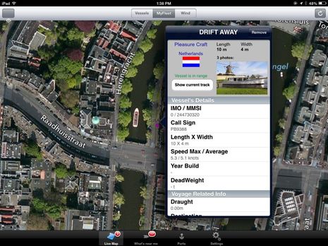
While I’m obviously an Internet AIS enthusiast, I should finish where I began. This spring there will be another spike of boaters with newly installed Class B transponders (good!) who will call their installer or supplier because they can’t see themselves on MarineTraffic or a similar site. Sometimes it’s because a forest of nearby masts in the marina kill the signal, but usually it’s because the location isn’t really covered, at least for Class B. We need to help folks out with this confusion and we need more receivers, I think. Meanwhile, one recent MT joy has been watching Yme’s electric Drift Away cruising the fascinating waterways of Holland in near real time. Do other armchair I-AIS cruisers prefer other sites or have ways to use MT that I haven’t discovered yet?


MarineTraffic was sure nice when I installed my Class B last summer – sure, I knew it was receiving, but it’s nice to know it was actually transmitting. It’s also fun getting an email when I fire up the boat..:-)
I have been using Marine Traffic since it started up, and I think it is really great. I used it to track two shipments of houshold goods across the Atlantic, my pickup truck on its RO-RO ship, and my boat as it was transported by a heavy lift ship.
Great app.
What kind of info can the volunteer stations upload? For example, could a yacht club insert the locations of its racing marks for a regatta? I assume you couldn’t put an AIS transmitter on a temporary buoy but what about the internet version(s) of ais?
Breezetrees, race management may one day be helped with either AIS “identifiers” (a kin of Class B) that attach to marks or virtual marks created by a single shore station. Maybe.
Citizen observers (Alden’s favorite term of volunteer AIS stations) can only pass what they receive to the sites like MT that database and display the data. AISdispatcher — the excellent and free (from AIS hub) program for doing it with a PC — does let the user throttle back the message rate, but it hardly matters for most of us these days. Even a very busy AIS area with zero throttling will barely make a dent in a standard household broadband Internet connection.
I am afraid that the “cutback” on free features already started with the new MT subscriptions. Previously you could get some limited Satellite AIS coverage with a free account. It was limited to just the latest 12 or 24hr Satellite pass, with no history displayed, but when following family on an ocean passage, it sure was a nice thing to know that sometime in the last 24hrs, they were located at XX by XX and at least in a good enough condition to have battery power running to the AIS.
With their new rather expensive Satellite service being launched, this data is no longer available to free users. I certainly do understand that they are likely paying a fair bit for that Satellite data, so I understand the need to make the business work, but I sure would appreciate an in-between service targeted to a more casual user. I think many cruisers would be willing to pay something like $10/month ($120/year) to allow a widget on their website allowing a single vessel’s position (fixed to a single MMSI and not readily changable) to be displayed even if the only signals coming into the network are from Satellite. It seems that most all of the globe is covered by at least one satellite pass per day and many areas get two or more passes per day.
My e-mails to MT asking about this went unanswered, but maybe they will read this comment and see a marketing oportunity. I have no idea what the cost would need to be to offset such a limited use, but it seems to me this wouldn’t really compete with their commercial Satellite service which is targeted at logistics professionals who need to know where all their shipments are located on multiple vessels at all times so they can properly arrange and expedite intermodal shipping exchanges.
Ben, what a great article. We installed a class B transceiver last seen and we were one of those people that were perplexed on why we were not appearing on Marine Traffic. We are located in central NJ and there are a few AIS stations clearly within reach.
One of the things that we were told by the Marine Traffic folks is that in high traffic areas like NY harbor, they filter class b vessels by the amount of time that they have been broadcasting. Initially our transponder was powered when our electronics were on; once we switched this to constant power we built up enough broadcasting time to be shown by Marine Traffic. The one downside is when we go into “ghost” mode during tournaments this resets the broadcasting time. Maybe this will help some other class b user saying “where am I”.
In our area we find that if we head north out of Manasquan Inlet we are best to use Marine Traffic and if we head south Vessel Finder is more reliable.
Thanks, James, but I’m surprised that MT feels any need to filter out Class B targets. I wonder why and will try to ask.
If I can get through, I’ll also ask about Gram’s low cost, low update position widget idea. I see that FleetMon seems to have a low cost way to buy single Satellite AIS positions:
https://www.fleetmon.com/highlights
I’m not sure that the satellites are very good with Class B, though. It’s not just the weak signal; I gather there’s some problem with data crosstalk when a receiver can hear transponders that are so spread out that they can’t hear each other.
The Satellites were able to receive signals from Visions of Johanna’s Class B (ACR nauticast B) on passage from New Zealand to Fiji every 12 to 24 hours without much problem back when I could track it, so while I am sure it isn’t guaranteed to get the signal every day, it seemed fairly reliable in the limited testing I could do.
While we were having issues with our N2K network (due to a busted GPS antenna), it was nice to use MT AIS as a 2nd confirmation that the AIS was not transmitting.
The 1st confirmation was the Simrad RS35 radio in AIS mode not picking up our own boat… of course for this to work, we purposely did not enter our own MMSI on the radio. Yes, I know, I know…
We now have a button on our blog that enables any visitor to see where we are by clicking on it. The button takes visitors to our location on MT AIS.
Good post Ben, I get lots of our Class B customers thinking that the online AIS sites like Marine Traffic are “perfect” and if they cannot see their newly installed transponder within minutes of firing it up, then they assume it must be faulty!
In fact Marine Traffic is good in this regard and actually have a menu option to show the receiving stations and whether they are online or not.
This article on our blog provides more information on this issue…
http://digitalyacht.net/2013/06/11/is-my-ais-transponder-transmitting/
Paul Sumpner (Digital Yacht)
I have noticed that Marine Traffic has significantly increased its coverage area — fewer blindspots, meaning presumably more reporters. I would not want to depend on it for navigation (it’s not a substitute for a chartplotter that can disply Ais information) but it is interesting to see who is around out of range of my own AIS.
The area near our marina in the western Long Island Sound is a notorious dead-spot for AIS coverage on MT, very surprising given the coverage in neighboring waters and the location’s proximity to New York City. With nothing to lose I approached the marina’s manager about the idea of installing a volunteer station and he loved it. Thanks to Marine Traffic’s program for assisting with these types of installations it is moving forward and should have a positive impact on the area as the 2014 season gets underway.
That’s great to hear, Anon. Make sure to put the marina name as Operator in their MT Station Registration and then they’ll get credit in the target details. Please also ask MT to forward the data received to AISHub, where it will get to apps like Smart Chart AIS.
PS I’m having MT fun today keeping an eye on the superyachts participating in the St. Barts Bucket. Here’s a link to Adela, which will get you to the live map:
http://www.marinetraffic.com/en/ais/details/ships/8955536/vessel:ADELA
Note that Adela and also Knickerbocker are also MT volunteer stations though neither seems to working today.
Great post Ben, Improving coverage is always on the top of our agenda here at Boat Beacon. We too run many of our own AIS Shore stations and can help with new installations- checkout http://pocketmariner.com/boatbeacon/cover-your-area
An interesting development in the EU is EMSA. They have used public tax money to provide AIS coverage for the whole of the European coastline. They have a €75 million annual budget and claim 100% coverage. EMSA are providing the real time AIS data via a system called SafeSeaNet. Typical of the European Government, this is only available to EU government authorities at present. I hope we can persuade them to make it available to commercial organisations too so internet AIS can gain an independent, stable and reliable platform.
What news is there of the US Government plans for coastal AIS coverage and what chances do you think there are that this will be made publicly available like the NOAA chart data etc. ?
Steve Bennet, Pocket Mariner Ltd.
Hi Steve,
I will add boatbeacon.com (54.225.113.225, UDP port 5322) to my personal AISdispatcher feed list and also to the list of sites I plan to encourage all volunteer stations to feed. I’m afraid that our governments aren’t going to help with this, or at least it will take them quite a while to see the light.
The U.S. definitely has at least one nationwide AIS listening system, simply called NAIS:
http://www.uscg.mil/hq/cg9/NAIS/
But though one stated goal of NAIS is “improving… navigational safety” the data is not available to the public. Our government even spent money to develop a free AIS app that would encourage small boaters to report their own identities and positions, but won’t provide the national AIS data that would probably make the app popular:
https://panbo.com/archives/2013/07/smart_chart_ais_needs_our_help_uncle_sams_too.html
Funny thing is that I heard the EU has a policy of making nationally collected AIS data available to businesses that want to use it, but I’ve never found any evidence of that policy online.
I see that Marine traffic is now offering a single vessel Satellite – Real Time tracking: http://www.marinetraffic.com/en/p/fleet-add-ons
14 Euro’s a month is a bit more than I had hoped for, but is well within the budget of a global cruiser/sailor who wants whole world tracking available to give family and friends a little piece of mind. As Visions of Johanna is back in coastal cruising mode in Maine, I won’t be giving this a try, but next time she heads offshore (maybe Europe next) I will be sure to sign up. If anyone else is signed up or does, I am sure we would all love to hear a report about the service.
Gram Schweikert
As a cruiser underway I would consider spending EUR14/month to allow all my friends and family to track me via sat AIS but the way I read this offer, each of my family and friends would have to spend EUR14 to track me. I doubt that any would go for it.
Also, is there any proof that sat AIS tracking would cover entire ocean passages which is where it would be needed most for a cruiser? If there were any unexpected holes in coverage, it would be most disconcerting for said friends and family.
While I am sure it is not technically allowed by their terms of service, you could easily share your login credentials with family and friends which would allow them to log in and see your track. As far as offshore coverage, my only experience was tracking on a trip from NZ to Fiji. While it took a bit of a trick to see the SAT data at the time (which no longer worked once they actually launched their SAT service), I was able to see twice daily updates along the entire route. In terms of satellite coverage in the world, other than the poles, the area between NZ and Fiji is some of the most poorly covered waters in the world (inmarsat has well known issues in the region). I don’t know what sort of satelites the AIS system piggybacks on, but I would suspect that more well traveled areas like the North Atlantic would get better coverage than that, and even still 2x a day is pretty good. Maybe Ben can ask Marine Traffic for a bit more info about the Sat tracking coverage as I think this new service plan puts it within reach.