
Navionics & Garmin part 1, long live Plotter Sync
 Did my planned back-to-back reviews of evolving Navionics and Garmin apps suddenly become moot when the Garmin acquired Navionics on Friday? I don’t think so! The terrific Plotter Sync integration I’ve been experiencing between the Navionics Boating app and multifunction displays from Simrad and Raymarine is not likely to go away anytime soon, if ever, and it may add significantly to your current navigation happiness. Moreover, many Garmin owners are about to receive a wonderful app gift, and while the different advances are not such a competition now, together they suggest the broad harmony between phones, tablets, PCs and MFDs many of us will eventually experience on our boats…
 These entries will also be a chance for me to preach about using routes to avoid navigation mistakes. I know that many experienced boaters understand their value, but the multifunction displays that otherwise deserve their popularity do not yet shine at route making, and these days many of us simply don’t do what our screens don’t make it easy to do.
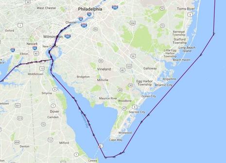
For example, the AIS track above shows a very well equipped and operated yacht that almost got to Philadelphia before realizing they’d missed the C&D canal. Now, they were never in danger because they were still navigating an elaborately marked commercial channel, but even a crude route showing the major turns on their chart screen could have prevented what must have been a “holy s..t” moment toward the end of a long dark night.
I’ve certainly had such moments myself, and this case of navigating to the wrong side of Cape Cod in a gale is perhaps especially interesting because I thought I was on a safe route. Creating, checking, and using a route to the next destination is a great start at good situational awareness, but a wise navigator regularly uses all resources available to check on their situation. In fact, one lesson of that terrifying moment off Cape Cod is that a wise navigator is slightly paranoid, as in “Sure, everything looks good, but what am I missing?”
 At any rate, the Plotter Sync route transfer feature of the Navionics Boating app has been an excellent tool as I first moved Gizmo at delivery pace from Maine to Annapolis (discussed here) and then slow cruised/tested down Chesapeake Bay to Hampton (tracked here). A major reason is the superb Dock-to-dock Autorouting I deep reviewed in late 2015. It seems even better now, and far ahead of other autorouting software I’ve tried, even including the same Dock-to-dock algorithms adapted to an MFD (at least currently).
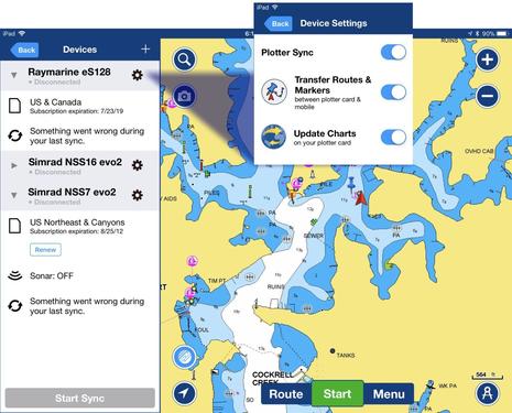
But I want my routes on a dedicated, bright marine display where I can use them with radar, sonar, autopilot, whatever chart type I want and more. And while the Navionics app has long claimed limited plotter sync, the big news today is how much they’ve improved the feature. In fact — I like to think that going to extremes is one way I can help boaters with many different systems and/or preferences — I’ve now got Plotter Sync working with Simrad and Raymarine MFDs (above) using Dock-to-dock auto routes created and edited on an iPad, an Android phone, or on a PC (using Navionics free web charts), and I’ve also been able to import them into other charting apps on various platforms.
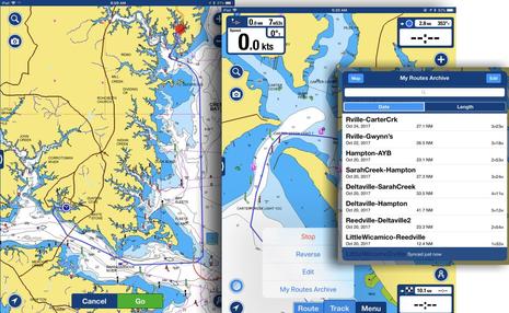 So let’s detail the process I often use, building routes on my iPad and then syncing them for use on Gizmo’s Simrad NSS evo2 displays. While sitting on Gizmo in the intriquing fishing village of Reedville (above), at rest with main navigation systems shut down, I was thinking about various harbors I could visit next. In less familiar waters like the Chesapeake — I’ve been here often over the decades, but there’s so much to savor — I’m often aided by printed guides, ActiveCaptain, and sites like Google Maps, Yelp, and so forth.
Getting a route to one possibility with total distance and time (at an average speed I’ve already set) takes three finger taps — invoke autorouting, start here, end there — along with a little zooming in/out, and a few seconds of processing. I check the routes at high zoom and sometimes add manual waypoints, also easy and fast, but usually they’re quite sensible and they honor buoyed channels while also highlighting possible issues of depth, bridge heights, etc.
I also try to give the routes useful names, because those names nicely transfer everywhere in the Sync universe. (But I’ve now learned that long names don’t necessarily transfer in full and that many special characters, like the apostrophe in “Rville-Gwynn’s” can break a route on another platform.)
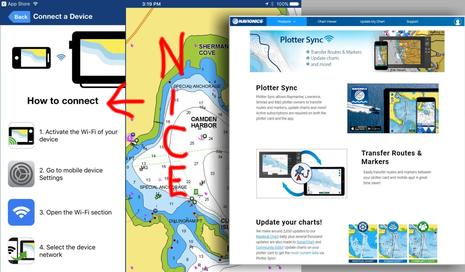
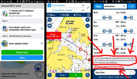
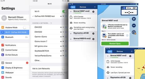 Now comes the Sync. Navionics has made it easier to understand how it’s done, as seen in my opening image, and also easier to see that it’s worked, seen above. First you log the mobile device running the Boating app onto the MFD WiFi, and, after a pause, you will hopefully see that your routes and markers (waypoints) have transferred. But there’s one more step, and first some notes are warranted:
* You’ll see the warning on the larger righthand screen that, “Something went wrong with your last sync,” but the only thing ‘wrong’ was that the card in slot 1 is not a Navionics card. Pop the non-Navionics card and the warning goes away, as seen inset.
* According to Navionics’ Plotter Sync page, “Active subscriptions are required on both the plotter card and the app,” but I’ve seen routes transfer to a 5-year-old Navionics card that hasn’t had an active subscription since and Navionics has confirmed that I’m not confused: “Plotter Sync requires active subscriptions on both mobile and plotter only to update charts; Routes and Markers sync as long as the mobile subscription is active.”
* If you check out the current version of Navionics’ thorough-seeming Compatability Guide (PDF here), you’ll see that NSS evo2 is not supposed to support Plotter Sync. But it does, as seen above, and Navionics again confirmed: “You are right and we are amending the guide. Navico units with WiFi or even with the external WiFi-1 can do Plotter Sync. There is one exception — the Lowrance HDS Gen1.” But if you check out this recent Forum entry, you’ll see that one techy B&G Zeus2 owner can’t get Plotter Sync to work.
So there may be glitches, good and bad, but consider the challenge Navionics has tackled. As a whole passel of compatibility guides suggest, they’re developing apps on all the big, fast-changing, and uncaring platforms — while the Boating app is iOS and Android only, the PC Chart Installer program and the browser app Chart Viewer are certainly part of the overall system — while also trying to integrate with all sorts of MFD operating systems belonging to marine electronics companies that may care too much about what Navionics is up to.
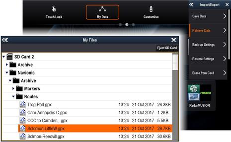
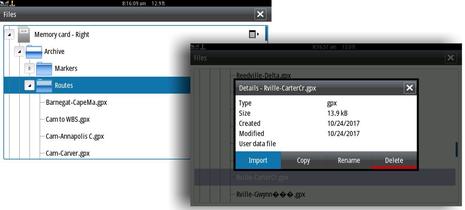 I don’t know if the last step in getting Navionics Boating routes to work on your plotter is a technical necessity or a mandate by the MFD manufacturers, but some boaters will find it annoying, at least at first. The routes and markers are synced to the Navionics card in the MFD, not to the MFD’s own route and marker database. So what I’m doing on the Simrad NSS7 evo2 screens above is using the Files menu to find the Archive/Routes folder on the Navionics card where I can then import them into evo2.
Navionics explains the Simrad sync process here, where you’ll also see that copying routes and markers from the MFD to the Navionics app requires a similar intermediary step in which the data is saved as a .gpx file to the Navionics card first. Either way is a little awkward, for sure — especially compared to the Garmin Bluechart Mobile sync style I’ve enjoyed since 2013, with which an app-created route can become the active MFD route in one step — but bear with me for the positives.
Once imported into the Simrad NSS, the routes appear in the plotter’s routes list with the same Navionics names (though maybe shortened), and that’s not true with the current Bluechart Mobile sync. With Navionics you can also transfer many routes at once, even use the “All_Routes.gpx” file you’ll find in the Archive folder to import them all at once. And the same is true of Markers, which could be a major boon to the fishermen who use them extensively. Be aware, for instance, that routes and marks synced to your MFD, or vice versa, are then backed up on your mobile and also to Navionics’s cloud if you’ve allowed this other form of sync in the app. But I get ahead of myself.
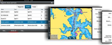
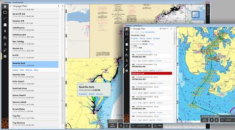
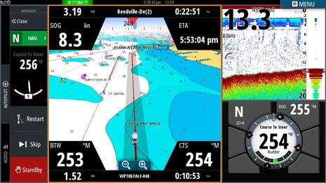
Going back to my recent personal routing process, note above that I can activate a NSS route either from the list or by tapping on the route overlaid on the chart. And then…
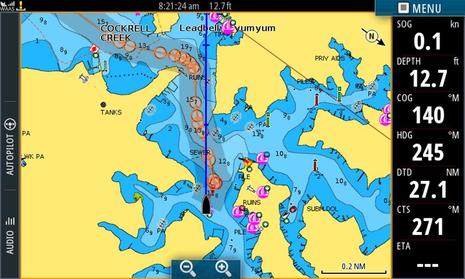 …Ta-dah! The NSS7 is ready to guide me along with Course to Steer (CTS) to each succeeding waypoint along the route — distance to waypoint, cross track error, and more are also available, just not shown here. Total Distance to Destination (DTD) can also be shown and the Estimated Time of Arrival (ETA) at destination or next waypoint (ETW), as well as times to destination or waypoint (TTD or TTW), will all be calculated as soon as I get moving and will respond to changes in current, course or speed. And the route I could have made at home or anywhere will be active on the NSS14 on the flybridge when I get up there, with numerous alternate routes ready to activate because the whole process is actually pretty easy once you get used to it.
I’ll add that I often deviate from routes, sometime due to changing conditions, sometime just for fun. The go-most-anywhere freedom of boating is too glorious to get overly rigid about a plan in my view, but having a route at hand is at least a good reference to what you figured to be a safe plan when focused on the subject. And you probably won’t miss a big turn into a canal in the middle of the night, or similar, or worse.
Sync on Raymarine
 The process of using Navionics Plotter Sync with Gizmo’s test Raymarine eS128 is very similar to the Simrad routine — Navionics how-to page here — but there’s another reason not to spend much time discussing it. Plotter Sync currently does not work on the Axiom series running Lighthouse 3, but it’s scheduled to fairly soon, and maybe at about the same time that the much improved LH3 interface comes to older Raymarine MFDs like the eS128. In other words, Raymarine owners may see the best Plotter Sync implementation yet, eventually.
But couldn’t Garmin’s acquisition of Navionics change this situation? Again, I don’t think so, at least not quickly. Why would Garmin give up Navionics chart revenues, and isn’t Raymarine’s main business hardware anyway? Heck, I wouldn’t be surprised if Garmin soon announces MFD support for the FLIR/Raymarine M200 thermal camera I’m finding so useful. This business is complicated. Then again, Raymarine has long supported C-Map cartography, Lighthouse 3 recently included, and the Navionics loss of independence may be a real opportunity for C-Map.
Sync on PCs
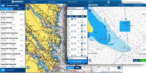 Now here’s an aspect of Navionics Plotter Sync that surprised me bigtime and very pleasantly: If you’ve enabled Sync My Data in the Boating app and you log into your Navionics account on the Web Chart Viewer, you can create, edit, and manage routes just like you can with the app. Except, of course, that means you can be doing it with a PC’s bigger screen and a faster processor, not to mention mouse and keyboard, and those remain the best tools for thorough route building in my experience.
The bigger picture is how the Chart Viewer confirms that your Route Archive is truly synced to the cloud and not just stored on your phone or tablet and maybe Plotter Synced to your boat system. And that led me to spend more time editing the archive and creating routes just to have on hand. And note that I’m not stuck in Navionics world if something better comes along.
 In fact, one reason I was looking for a good routing tool (to use in earnest, not just test) was the retirement of the old PC that once made Coastal Explorer’s excellent routing available at the lower helm. It does not have autorouting, but I do miss CE features like WPx, I admire other PC charting programs like TimeZero, and I may change primary tools again. But did you notice that Plotter Sync files are in the standard .gpx format? That means I could stick a Navionics SD card into Gizmo’s remaining PC and import the whole “All-Routes” file into CE, no problem.
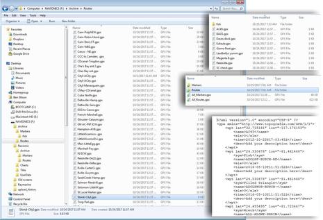 Here’s an even geekier way to see what I’m talking about, and also that the .gpx flexibility applies to marks as well. I guess you can say that Navionics’ remarkable Dock-to-dock autorouting can be used in just about any charting app, with a little work. And they can live in your own cloud storage even if you end the subscription that makes Dock-to-dock and Plotter Sync exporting possible.
Sync on Android
I also tried Dock-to-dock routing and Plotter Sync on the Android version of Navionics Boating running on my Samsung 4 and it worked fine. And while I don’t find even a high resolution 4-inch screen sufficient to properly check a route, again this app instantly synced to the Navionics cloud (as long as the phone had service) and that meant the routes could be vetted on a much bigger screen.
Note how I have highlighted the caution Navionics often expresses, and please take it seriously. Good routing is a valuable tool, but hopefully only one in your navigation kit. I fear that even the most experienced of us are getting a little lulled, and I’m working on an entry that illustrates, as well as the Garmin app gift story that’s coming very soon, plus a look at how the stalwart iNavX nav app has evolved.
Finally, check out this final screenshot. You may have noticed that Navionics Dock-to-dock often creates a lot of waypoints, and they can look pretty messy when zoomed out. But the abundance of turning points also means that a Plotter Sync route can use your autopilot to precisely steering a tight, winding channel. I’ve rarely allowed Gizmo’s autopilot to steer a route, but I’m experimenting with it now, cautiously.


Hi Ben,
Thanks for the detailed write-up. Spot-on as usual.
You had mentioned another technical user having difficulty syncing Navionics routes created on a tablet with their Zeus2 plotter.
We also use Zeus2 MFDs with Navionics [and C-Map…] charts. We also use the Navionics app on a couple of iPads and iPhones, and have no issues syncing both chart updates and routes from any iOS device to the MFD with the Navionics SD card. [All devices have current versions of firmware, OS, and apps…] The workflow is identical to what you described for your Simrad NSS evo2 displays.
We, too, find the Navionics routing on iOS to be very robust, but still requiring critical scrutiny to adjust to suit our needs and preferences.
Regarding Garmin acquiring Navionics: an additional desirable outcome for me would be Active Captain [AC] integration into Navionics. We currently use other nav programs to access current AC info when offline as we find Navionics crowd-sourced location information totally lacking- at least in Alaska. Not so with AC.
In case this is useful.
Cheers! Bill
Ben – Thanks for the in-depth review of this capability.
I believe you are correct, it would be irrational for Garmin to give up the revenue that Navionics wide platform support brings.
An interesting question to explore, with C-Map under Altor/Navico and Navionics under Garmin, the future appears to be multi-function software as the new end to end marine integration platform. Like digital home for the boat.
Of three mobile apps I have, Garmin BlueChart provides the least value and I have seen no apparent improvement over the last 3 years of use.
I ask the following somewhat rhetorical questions, more of Navico and Garmin:
Will Garmin gracefully end of life BlueChart, moving features and support to Navionics creating a single mobile experience? This would make economic sense but for the benefit of consumers, Garmin should communicate the mobile product roadmap soon after the acquisition is complete.
Will Navico improve the user experience with C-Map mobile platform? In my opinion it needs significant ease of use and graphic improvements.
I use various programs on Macs and tablets for off-line route investigation and sometimes for on-boat navigation via WiFi gateways. I’m able to do so because of standards like NMEA-2000 and NOAA’s decision to make US charts freely available in both raster and vector form.
GPX files are an almost-standard XML-like (text file) format that allows interchange of waypoints and routes between devices, but it turns out that manufacturers pollute the files with proprietary fields that prevents interoperability without manually hacking the files. A real hassle – would be so much nicer if they’ed cooperate, and I’m not interested in cloud-based solutions when I’m navigating off-shore.
In a similar vein, I’m helping someone spend almost $20k on a complete set of new nav electronics and autopilot for offshore racing and find that the chosen vendors software can’t accept charts directly from NOAA like my laptop does. Instead they require a subscription from a firm that gets the charts for free, puts them into a proprietary format, then charges for something that was already payed for with my tax dollars, often months after the update came out! (We call this value-subtracted.)
The success of NMEA-2000 should be showing marine electronics providers the advantages of standardization – nickel and dime-ing customers is a sure route to losing a market.
A frustrated Fogmachine
Hi Ben,
Thanks for the detailed write-up. Spot-on as usual.
You had mentioned another technical user having difficulty syncing Navionics routes created on a tablet with their Zeus2 plotter.
We also use Zeus2 MFDs with Navionics [and C-Map…] charts. We also use the Navionics app on a couple of iPads and iPhones, and have no issues syncing both chart updates and routes from any iOS device to the MFD with the Navionics SD card. [All devices have current versions of firmware, OS, and apps…] The workflow is identical to what you described for your Simrad NSS evo2 displays.
We, too, find the Navionics routing on iOS to be very robust, but still requiring critical scrutiny to adjust to suit our needs and preferences.
Regarding Garmin acquiring Navionics: an additional desirable outcome for me would be Active Captain [AC] integration into Navionics. We currently use other nav programs to access current AC info when offline as we find Navionics crowd-sourced location information totally lacking- at least in Alaska. Not so with AC.
In case this is useful.
Cheers! Bill
Ben,
Thanks for this article. I think developing routes on a laptop or tablet and transferring to a chart plotter is a very good thing. I teach the USPS Electronic Navigation Systems course and this is one thing that I emphasize to students.
Garmin’s ActiveCaptain app arrives. It includes the AC cruising data but it’s actually a whole lot more. I’ve been using all aspects of it for a while, and will do more testing today, with full review coming soon:
https://buy.garmin.com/en-US/US/p/573254
Hi Ben
Nice article on the Navionics App. I have been using it for a number of years on my smartphone as a supplement and back up to my Garmin 3210 plotter (reason for not updating was noted in comment on your discussion about WPx function of Coastal Explorer referenced above).
I have played with the auto-route feature and find it a seemingly great tool. And I used the WebApp Viewer to create routing on my PC and sync with the phone.
However, it is not very useful if I cannot get the route transferred to a GPX file that I can access via computer. I could then use Garmin Homeport (that I like very much for route making and trip planning) for final review and then transfer to the plotter. Think I am in the same boat as many other users that do not have MFDs with wireless connections.
Therefore, my question is one of clarification to the discussion above. Is there is no way to transfer the GPX files from the app without use of a wireless compatible MFD?
Regards
Ron
Great question, Ron, especially because I can reply “Yes, you can.”
When you have an individual route menu open, there’s a share button just right of the route name. Use that to email the route to yourself and besides a screenshot of the route you’ll get two links, one to the ChartViewer and the other to the route in .kml format (which is very close to .gpx, and easily converted).
It’s only one route at a time, and little convoluted, but it works with iOS or Android Navionics Boating. Here are some links I just generated that you can try:
Route shared using Navionics App.
View it: http://tinyurl.com/yclhgoyc
Download it: http://tinyurl.com/y8ekt2l9
Route shared using Navionics App.
View it: http://tinyurl.com/y72dqu4l
Download it: http://tinyurl.com/y95xby67
I agree that a PC far and away the best device for plotting and chacking routes. Massive resolution, large screens, and a mouse and keyboard (still the best interface).
This is why I’m actually disappointed. There is no Navionics package available for PC/Macs, ok we can use the webapp, but pretty much every feature of it is turned off. You can save routes, but you can’t export them. Yet visit the same webapp on your mobile and you can export (even if you don’t have a paid up subscription).
Likewise, you can’t add comments or give feedback (fair enough if you haven’t paid), but then why allow it on mobile.
I also found that when exporting routes to manually bring into my NSS 8. That the routes aren’t GPX format, and need converting. Bizarre.
My biggest disappointment in all this, is that Simrad do not have an application that allows you plan and plot routes on your computer for uploading to the plotter. Garmin has it for portables (bascamp), and I believe for it’s MFDs, I think even Raymarine has something, but there is no such application from Simrad, which is why we have to turn to Navionics. Unfortunately we can’t use grib files and have weather routing, but maybe that will come.
Right, Mike, but most PCs are not great for underway navigation, one reason they’re not used at many helms. At any rate, Simrad does offer PC planning software, though only in the U.S. for reasons unknown:
https://gofreemarine.com/apps/insight-planner/
Let’s not ask for more PC software / give the impression there is a market for it! Most vendors who have created and market PC apps don’t get enough volume to support it/ keep the developer around and we are stuck with something that does not evolve and is hard to move when we replace our device.
Laptop/Desktop software needs to be browser based where we don’t (conciosously) load software and the data is stored in the cloud.
For our smartphones and tablets, install an app maybe, but keep the data in the cloud and at most buffered on our devices.
Obviously the above does not apply for using a PC as a chartplotter, but nearly everything else does not have enough PC users to meet demand like an Android app or cloud based solution.
Dan,
I do not agree that planning software should be browser based and/or data should be in the cloud. I often cruise in areas with no WiFi or Cell coverage and I plan routes on my laptop. I know many other people that do the same.
As a matter of fact I keep a library of routes that I’ve planned on my laptop for use in the future. Sometimes I’ll use a route as-is; other times I will modify a route to get me to a different destination.
Currently I run Navico equipment, but use Garmin’s HomePort to plan routes and save them as .gpx files. I do this because the Navico’s Insight Planner software is very user-unfriendly.
You may be right in general, but I know many people (including myself) that now navigate offshore with laptops and tablets more than via an MFD. In fact, the last several trips (each over 200nm) we didn’t even turn the MFD on unless we wanted radar. Maybe they aren’t commercially viable, but laptops sure are convenient.
The current project added a MFD more for flexibility and reliability than functionality. It’s certainly going to feel odd seeing three WiFi networks available when land is out of sight.
Wow…
I feel so very lonely. I still consider my paper charts the gold standard for routing.
I have tried using my laptop, and do truly hate it. It is awkward, power hungry and fragile. Sailing outside the US now means that I need to buy THREE sets of charts: One for MFD, one for laptop, and paper. You will pry my paper charts from my cold dead hands!
My MFD is used for local situational awareness at the helm, and it is very good at that, but for routing? It is tedious, terrible, and error prone to try to really review a long route at all the various zoom levels needed to be sure the route is safe and clear. And that problem is NO better on a laptop, or (shudder!) a tablet. For most passages, one, or at most three, paper charts are really all that is needed to layout a detailed, safe, route.
And really… the example of the boat sailing past the C&D canal as a reason why I should set up a turn-by-turn electronic route??? That’s just head-up-the-butt sailing. But I guess if they had set up a route and programmed it into the autopilot, they could have just continued to sleep all the way to the Chesapeake and would not have had to wake up to turn around.
I know as a world-wide ocean cruiser my problems are vastly different from someone who stays in US waters where electronic vector and raster charts are readily available–and free. And if you get hit by lightening in the middle of the Chesapeake, finding you way to a safe harbor without electronics is not so hard.
No boat I am on will ever sail a route picked by software without my detailed review. If I am going to review it, what do I need the software route for? Is it really THAT hard to route a boat without running into things? If nobody actually goes over the route in detail how do you ever know if things are not right?