Category: Navigation

The XTE issue, autopilot behavior & electronics dollars 53

The XTE issue, autopilot behavior & electronics dollars

autopilot_testing_in_the_rain_cPanbo.JPG

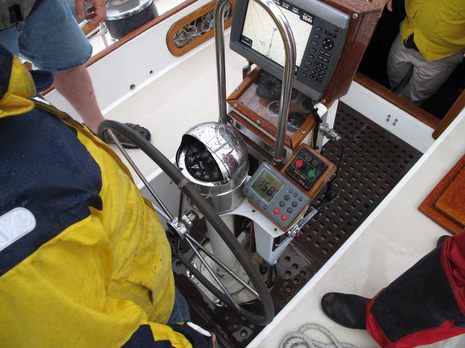
All those bodies boating in the rain represent a lot of money spent over a problem never fully “solved”…which may be why I let the story gather dust for many months. Two are representatives from Raymarine who drove several hours to investigate why the boat’s new ST7002 control head and SPX30 course computer autopilot system was still making the owner very unhappy. The other two are employees of Wayfarer Marine, which had already put about ninety hours — some of it uncharged — into what had seemed at first to be a simple replacement needed because the boat’s original Raymarine 300 course computer (manual PDF still available) stopped turning in one direction. Anyone with an autopilot, or concerns about the cost of marine electronics, might want to know more about what happened…

Simrad NSS, hand’s on #1 21

Simrad NSS, hand’s on #1

NSS_pages_screen.jpg

I’ve already written about the debut of Simrad NSS “touch sensible” MFDs, as well as some of what I learned about Navico in Spain, and today I’ll discuss some of what I saw during the on-water demos.  I was especially curious as to how the NSS replaces the NSE’s super fast direct access keys. Actually, I don’t think it’s possible to swap screens faster, or easier, than those NSE dedicated Chart, Echo, Radar, etc. buttons, which get you last-layout-used with a quick press and a list of available layouts with long press. But the NSS comes fairly close…  

Northwest Passage with Starpath, plus its nav rules app 4

Northwest Passage with Starpath, plus its nav rules app

Starpath_Quark_NW_passage_cruise.jpg

Twenty-three days on a Russian ice breaker following Roald Amundsen’s 1903 route through the Northwest Passage? Hell, yes, especially with David Burch — navigator extraordinare, and founder of Starpathriding along as tutor and guide to the vessel’s bridge. If I had the money and the time (heck, it took Amundsen three years), I’d seriously consider this opportunity. For one thing, the venerable Kapitan Khlebnikov is going back into government service, and this may be her last Passage passage. And for another, the high latitudes — where compasses, celestial navigation, and even many forms of modern communications all get dicey — are what nav-obsessed gents like Burch live for…

Simrad NSS series, touch sensible? 20

Simrad NSS series, touch sensible?

Simrad_NSS_series.JPG

Say hello to Simrad’s new NSS Sport series of multifunction displays — the NSS7, NSS8, and NSS12 — which are making their global debut today. They seem to have all the capabilities of the NSE series (which they can network with) plus a built-in GPS and, in the case of 7- and 8-inch sizes, a built-in Broadband fishfinder as well, along with quite competitive price tags (suggested retail prices of $1,895, $2,845 and $3,995 respectively). But the key feature is an LED backlit touch screen that is nearly as bright (1200 nits) as the NSE’s (1500), and which Simrad has used to create a combination knob, button, and touch interface it’s calling “Touch Sensible”…

The LightSquared problem, time to join “Save Our GPS”? 119

The LightSquared problem, time to join “Save Our GPS”?

LightSquared_GPS_jamming_test.JPG

When many readers sent me the GPS World article on GPS jamming, I was blasé.  How could the U.S. government possibly allow LightSquared to put up 4,600 transcievers pumping broadband data services in the L band with such power that they’d significantly interfere with nearby GPS frequencies?  As in complete failure at over half a mile for a high quality civilian GPS receiver like the nüvi 265W, even under an open sky, and almost six miles for a critical GNS 430W aviation unit (as ascertained in lab testing done by Garmin and Trimble, results PDF here).  But then again I never thought our government would be dumb enough to kill the eLoran GPS back-up system just to save a few dollars…

MIBS #4:  FLIR & PYI Seaview, Furuno & Oceanview 3

MIBS #4: FLIR & PYI Seaview, Furuno & Oceanview

PYI_Seaview_3FL_Pod_cPanbo.jpg

Here’s a clever idea.  PYI worked with FLIR to create an accessory podlet for several of its Seaview MFD pods that serves as an integral casing for a relatively inexpensive (“just over $2,500”) thermal camera core.  The core’s output goes to the video input of whatever MFD is mounted on the working side of the pod so the user then has a simple forward-looking thermal view that can even be aimed using the pan and tilt abilities of the pod.  There’s a major limitation to this idea — the fact that thermal can’t see through glass or plastic — but I can think of situations where it might make a lot of sense…

PolarView, ready for prime time? 36

PolarView, ready for prime time?

Polarview netbook.jpg

I took a peek at PolarView NS charting software about a year ago, but didn’t write about it because I wasn’t especially impressed (and there’s a certain randomness to what I cover anyway).  But times change and software develops, and I’m here to tell you that PolarView 1.5 (video introduction here) is pretty darn impressive.  Given its app-like $40 price tag, it’s a remarkably powerful program that runs on Windows, Mac OS X, and Linux operating systems.  The screen above shows PV running on my little ASUS Eee PC 1000HE 10-Inch netbook
with live NMEA 0183 data coming from the lab’s N2K network via a Maretron USB 100.  PolarView is quite unusual in that it uses a sister program, called PolarCOM, to do all its data interfacing and instrument displays… 

“GPS testing”…or do they mean jamming? 39

“GPS testing”…or do they mean jamming?

FAA_GPS_warning_Jan2011.JPG

This seems odd.  Yesterday the FAA issued a Flight Advisory — PDF here — warning that during a period of “GPS testing” starting today aircraft transiting the large area diagrammed above could find that “the GPS signal may be unreliable or unavailable.”  WTF?  But never mind sites like Engadget which immediately assumed that “anyone planning on using GPS in the southeastern US for the next month or so will likely want to make sure they have a fallback option.”  If you read the Advisory carefully you’ll see that whatever is being tested — which sure seems like jamming to me — will apparently be more effective at high altitudes than on the levels most of us travel…

Garmin GMR 604 xHD, hand’s on 10

Garmin GMR 604 xHD, hand’s on

Garmin GMR406 Jonesport harbor cPanbo.JPG

So that’s the Garmin GMR 604 xHD open array radar I installed last May painting a crowded harbor on the screen of a GPSMap 7212 in late July.  Gizmo was headed southwest at the time — the GPS heading, or COG, is meaningless because she’s tied up to a float — and so you have to twist your brain a bit to see how well the radar is imaging the details of Jonesport’s Sawyer Cove, and hence that the long straight target at the upper left is the famously uncharted steel and concrete breakwater there.  And I think if you make the comparison you’ll agree that the true color target display really helps to understand what the radar is doing.  Those light blue and green returns at upper left, for instance, are almost certainly some sort of noise created the breakwater’s heft and hardness.  I could have turned the gain down to eliminate that noise, but then I might not have seen the light blue at lower left — which is an emerging mud flat, I think — and similarly difficult targets once I got underway.  True color returns is indeed my favorite feature of the xHD/7212 combination…