gTrax & Ship Tracker, telling it like it is
When I recently looked into the dismal-looking future of eLoran in the U.S., and read some of your comments to that entry, I felt obliged to write Secretary Napolitano asking her not to kill the Loran system. My most unusual, and hopefully persuasive, argument was that she would be serving her boss — President Obama — best by reversing a poor decision that he’s endorsed, even crowed about. Telling it like it is, even when that’s contrarian, is often the most constructive thing we can do for our friends and colleagues. It’s in that spirit that I feel obliged today to note that my friends at gCaptain have introduced an iPhone AIS app that doesn’t seem competitive…
The most important thing about a remote AIS viewer — be it on the Web, or an iPhone, or wherever — has to be the data feeds it uses. You’re only going to see the targets that are being fed to the viewer by whatever local receivers it’s networked to, and if they don’t include the area or vessels you’re interested in, all the other features don’t mean much. A major plus for gTrax, as explained on gCaptain, is that it uses a commercial network of “redundant secure” receivers. But, geeze, that network doesn’t seem very extensive, covering only about a dozen U.S. ports, and in some cases, like Boston, the port coverage seems pretty limited in range. Plus gTrax, which costs $5, only shows you port data in near real time once every 24 hours; to get a continuously streaming feed costs $10 per month, per port!
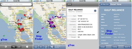
That fee structure may make sense to certain people who work around a particular port, assuming the feed is truly reliable, but others may be surprised when they compare gTrax to other AIS apps which use volunteer feeds, like Ship Finder. I did just that for several ports last night, and you can see some results in the screen shots above. Note how the San Francisco coverage seems very similar. Other port comparisons varied a lot — gTrax covers New York well, for instance, while the Ship Finder coverage seen in that link above is, um, intermittent — but right now Ship Finder seems to have a lot more coverage overall, and you get slightly delayed data for just $5, no subscriptions needed.
Note too how Ship Finder can “Lookup” a given vessel at MarineTraffic.com, and thus can often show photographs, track history, etc. (as I discovered recently). While that sort of database linking seems like one of the neat things an online AIS viewer can do, gTrax doesn’t have any such features yet. Plus there’s the matter of how that gCaptain link above appears to be offering t-shirts and Starbucks cards in exchange for good gTrax reviews at the iTunes App store. I think it was just an error of over enthusiasm, but you have to wonder about the eleven reviews — all five star — ‘earned’ so far.
However, poking around the app store also led me to discover another brand new AIS viewer called Ship Tracker, which may give Ship Finder some real competition. Information is a little sparse, but I spent $2 to try it and found some nice surprises, as shown below. Note how a vessel photo, if available, is shown with the basic info, and how a day’s track is also available (if it was within receiver sight). This AIS site — though in Greek — show’s the app’s general coverage areas, which unfortunately favor Europe over the U.S. That may also be true of Fleetmon mobile, yet another new AIS viewing app. It costs $25, but the coverage area and added features seen on the Digital-Seas parent site look quite interesting. Online AIS and smart phone apps are both changing at breakneck speed, and you may have to be a curmungeonly contrarian to keep things sorted.




Ben,
Many thanks for the accurate review. I will say that personally I use Ship finder on a daily basis, love the ship history feature of Ship Tracker and the team at Jakota cruise systems (Digital Seas) are my personal heros. The competition is tense indeed but like a mentor once told me… one ship crossing the atlantic is boring but add a second ship and you have a race!
You picked up one major advantage of gTrax (Pro-Level feeds) but the second is user interface design. The iPhone is simple, accurate and fast… gTrax was designed to be the same. We limited features on purpose (if they were buggy, superfluous or inaccurate, we took them out) and invested many man-hours designing and locating each button to make our app simple and powerful.
But, gTrax, unlike the others, is not an AIS program, it’s a marine data platform that, like google earth, will expand in usability and features as we move past Version 1.0. Standby, I think you are going to be impressed.
The bottom line is if you want fast, accurate and simple viewing of AIS targets and you live within one of our covered regions…. then consider gTrax. If you are looking for unique features, “extras” and numerous regions pick another program (I’ve tested them all and they work great). My only request is that if you do pick another program bookmark gTrax and stop back in a few months as AIS is just the tip of the gTrax platform.
-John
Captain John Konrad
Master Mariner | CEO
Unofficial Networks LLC
p: +1.805.456.8644
http://www.gCaptain.com
I gave it 5 stars and frankly I’m instullted. I could care less about a shirt and I hate starbucks. Have you seen the gCaptain forums, John gives 110% to everything he does and has passion about the gCaptain membership so we have passion for him. Don’t you think that’s why he has 11 ratings?
I haven’t tried any of the other apps you mention but gTrax is easy to use and never crashes (liek most apps). And why are the regions an issue, if your city ain’t covered then don’t buy the danm thing. Right?
The app works great. I give it 5 stars and another 5 to John. Ben get’s 2.5
Good on you Ben for telling things as they are and not falling into the trap of endorsing anything that comes down the blogger pipe. My impression was the principals at gcaptain didn’t really watch what they were buying from whoever sold them that app.
Bob, for good or bad the buck stops here. I built it from the ground up by the gCaptain team (including our forum members) and iPhone programmers sitting 20 feet from my desk. Nothing was bought… it was developed to my specs and I’m proud of the results.
-John
If you’re willing to be at the mercy of volunteer AIS feeds, Ship Finder etc are just fine, I’m sure. If you need the reliability of a commercial feed, it comes at a price. Just like anything else in this world, you get what you pay for. As John Konrad correctly points out, any first generation app has nowhere to go but up. I’m convinced that gCaptain is off to a good start with gTrax. The people who bought the first production run on the Toyota Prius were looked at strangely, but hey, now shipyards are building hybrid tugboats! The early adopters in this case will be glad they chose to buy gTrax.
I purchased the app and like what I see. Unfortunately it doesn’t yet cover the waters where I work, about 60 miles from a covered port, Seattle in my case.
Richard, Both Ship Finder and Ship Tracking are showing vessels around Oak Harbor, Anacortes, Bellingham, Victoria, and Sydney right now. I saw a ferry going into Friday Harbor a little while ago, but other than that there are no targets showing amongst the San Juans.
Ben,
Great post as you would do always. I find shiptracking pretty impressive, except for that reason its not helping me to read it in
english:). I had even tried to translate it through google translate, but to vain.
Best Regards.
-Dani Gorgon
Ben,
Of course both Ship Finder and Ship tracking show the same targets and I’m willing to bet DigitalSeas shows the same one too. Hint, They’re using the same crappy feed. I’m with the rest of the commenters, gTrax really is not that bad. How long did you have it installed on your phone before writing this negative review?
They might be using the same feeds for that area, Zack, but that’s certainly not true everywhere. Ship Finder and Ship Tracking coverage are very different in the Northeast, for instance.
I checked out Boston this morning and gTrax is showing better range than it did the other day, but Ship Finder is still showing every target gTrax does plus a few targets in the Boston approaches and down around Quincy that gTrax isn’t. Ship Tracking is only showing two vessels in the outer harbor.
I don’t think it makes sense to presume that all volunteer feeds are “crappy”. A volunteer isn’t under any obligation to maintain a good feed, but it’s obvious that some of them do.
“to get a continuously streaming feed costs $10 per month, per port!”
I guess I’m one of the very few who refuse to pay a monthly charge for any data or service regardless of how useful it may be. The primary reason is because as a retired, fixed income cruiser, $10 a month per port is just unaffordable. That becomes $120 per year for one port and one iPhone app. Two ports makes it a $240 app per year plus the AT&T data plan cost. And, what good is having this expensive data when not one of the AIS apps allows you to search for a particular vessel. Next we might see NMEA requiring a meter on the N2K backbone so they can send us a monthly bill for all depth and boat speed PGN’s that are used.
All I need is the free data that feeds into my onboard AIS receiver and shows up on Coastal Explorer. If and when the government starts to charge for using GPS I’ll go back to my sextant and paper charts with pencil.
I wish you the best with gTrax as I’m sure there are many who don’t have a problem paying monthly for weather, XM Radio, AIS iPhone apps and other product rentals.
Ship Tracking does have an MMSI or vessel name search function, Richard, and it works over the app’s entire coverage area. It also has a “Favorites” feature that I’m getting very fond of. The developers put a lot of fresh thinking into this $2 app, even in version 1.0.
It is nice to live on the great lakes. Every ship transiting the canals needs to have AIS. The seaway posts data in RT of ship transits. The idea of paying $5/month for an iPhone app that is updated daily is dumb, assuming you can lookup where ship are elsewhere (i.e. by browsing sites on your iPhone). My greater fear is that folks will check things off an app that has no guarantee of accuracy (only a fool would provide one) and the user takes it as the truth. I have a chartplotter and AIS, and that is the only way to go… iPhones, BlackBerrys, etc. all are not marine grade units, and shouldn’t be trusted to provide accurate information.
Owen, I hope you aren’t assuming that what you see on your chart plotter and AIS is accurate? eNav products are wonderful until they’re taken out of the box and installed. Then, they become useful only if they are properly installed, set up, and operated by someone trained to understand their weaknesses as well as their strengths. In fact, when I train people in their use, it is more important to me to check for my students’ understanding of the pitfalls of eNav equipment than for their understanding of the cool features and all the bells and whistles. If they learn that, I know I’ve done my job. gTrax is a great tool if used properly and prudently, but no one should use it as an aid to navigation, ever.
Isn’t that true of every form of navigation, Doug, traditional and electronic? When I taught the subject, one of my central themes was that a good navigator was nearly paranoid. What mistake could I be making here that can get me in trouble? What assumption, what sensor, is trying to ruin my day?
A well put corollary can be found in Roger Taylor’s wonderful Elements of Seamanship, in which he suggests that every boat wants to sink and one of your primary jobs is to make sure it doesn’t. The chapters:
– Keeping the water out
– Keeping from hitting anything
– Keeping her going
– Keeping her where you want her
– Keeping your reputation
The Elements of Seamanship
Ben has a good point. I downloaded gTrax and it’s not perfect but it does work smoother than Ship Finder and the feed I am using does seem to be more stable.
The best lesson I ever learned navigating is to do everything three times. Before I just had radar and ecdis but now I have radar, ecdis and gTrax. I give a lower weight to gTrax than ecdis (radar is still my primary nav aid) but cross checking equipment and solutions 3times has saved me on many occasions. gTrax hasn’t saved me yet but because it is quick and easy I will be using it as a quick check and I fully expect it help me identify a fault in the other systems at least once during the duration of my career.
So my rating is 4. Not perfect but the best existing solution for serious navigators.
Check new Site http://www.shiptracking.eu
and iPhone Application Ship Tracking.
http://itunes.apple.com/us/app/ship-tracking/id346794782?mt=8
It’s better.
You can also check the free version of VT Explorer at AISHub:
http://www.aishub.net/
This site is a volunteer AIS data sharing in raw NMEA format. AISHub provides streaming (not updating on regular time intervals) in it is very close to the real time operation.
Did anybody try out Fleetmon :mobile for the iPhone yet ?
Some US ports are covered and it has a very nice vessel database with images.
http://www.digital-seas.com/iphone