iPhone apps update, & the future?
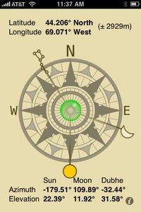
It’s hard to keep up with marine related iPhone apps, and the reviews at Apple’s iTunes Store often don’t help. The Celestial Compass above, for instance, has seventy 1 or 2 star “this app doesn’t work/sucks” type reviews versus just fifteen positive ratings, even though it does exactly what it purports to do, and that’s not trivial. Admittedly ‘compass’ may be a confusing name, but this app uses spherical trigonometry and an ephemeris to calculate the bearings (azimuths) of three celestial bodies at your location so you can line one of them up with the screen and thus orient yourself to True North, E, S, W, etc…
When I built my home in 1978, I recall using two techniques to assure its True South orientation — a compass which I corrected to the local Magnetic Variation taken off a chart, and the shadows at the time of Local Apparent Noon as calculated with my Longitude and the wondrous Equation of Time for that day. The $.99 cent app above would have been a lot easier, but at least it shows that my efforts worked; I took that screen shot when the shadows lay straight back from all my south facing windows, and it confirms that this house is a giant sun dial. It also shows why we’re early risers in Maine (we’re way over on East side of the Eastern Time Zone) and how pathetically low the Sun is even at true noon at this time of year. This app could also be used to check a compass, as long as you know the local Variation, and can get a good bearing on the Sun, the Moon, or the Big Dipper.
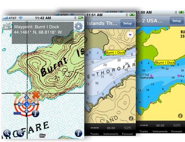
All of which is a long winded way to say that there are some amazingly neat little apps out there, and I hope you all will share your favorites here. And I have a couple more to trade, like Fugawi’s new iMap seen at left below. There may well be more full featured and faster topo map apps available, but iMap (currently priced at $4.99) not only gets you access and caching of all U.S. and Canadian topo maps, but also an X-Traverse account that makes it very easy to share tracks, routes, and waypoints with iNavX (as shown below), Fugawi ENC, and actually many other programs and plotters via the .GPX format. iMap also has a nifty touch screen waypoint edit control that all developers should take a good look at.
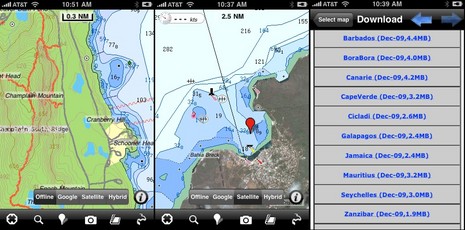
Then there’s FlytoMap All in One. The price has gone up to $4.99 since they wrote the Web description, but still the app gives you download rights to a phenomenal amount of data. Like all U.S. ENC charts (though remember NOAA hasn’t completed coverage yet), plus detail of some fifty national parks and a wild variety of exotic destinations. The shots below show Acadia National Park with topo, trail, and ENC detail; vector chart detail (and Google photo map overlay) of Cristobal, Galapagos (where VOJ was recently); and a partial list of Flytomap downloads. The book icon, by the way, indicates guide information, but it seems pretty generic.
 Of course all the marine apps I’ve written about already — like iNavX, Navionics Mobile, Navimatics and ShipFinder — keep improving, and I’ve never even gotten into all the weather apps available. It’s weird how big a subject this has become, and I’ll soon be trying to sumarize the state of things for Cruising World. I’d appreciate hearing about what apps you cherish onboard, and where you think this whole smart phone, apps thing is headed for boaters.
PS 12/23: Nick sent in the screen shots below of the apps he’s been using as he and Sherri cruised some 6,000 miles on Sweet Time, well blogged here. Hopefully he’ll add some comments about their favorites!


Some app ideas from ActiveCaptain’s Jeff Siegel:
http://www.yachtforums.com/forums/87097-post29.html
Without taking anything away from the iPhone, I’d like to see some of these fine applications ported over to the Android cell phone operating system. Then you’d get useful navigation assistance but with Verizon’s great coverage.
Android already offers free turn-by-turn voice GPS navigation on land, and includes a satellite layer option. How nice to have it for coastal navigation on a misty overnight transit — “In 100 yards turn to port to new 250 degree heading at nun buoy 12.”
Jess, I’m really interested in the Android platform, too, but I did read some convincing evidence recently that Verizon’s data network superiority is quite exaggerated (can’t remember where I saw that, unfortunately). On the other hand, there are many rumors about AT&T planning to choke down heavy data use.
The IPhone has become my “batman utility belt”. It is no longerabout the phone, but the utilities of the device.
Non-ATT users keep saying that ATT covrage is lousy but I travel the world and have had very little issues.
As to certain apps, besides the ones this forum is most familiar (navigation) I use regularly on board:
* Flashlight (with a red filter for night time)
* Fishbook (fishing log book)
* Dive Log (dive log)
* Nav Rules
* NOAA local marine forcast
* Xpensetracker (for tracking costs)
* Quckoffice (keeps word, excel and pdf files of all my boat documents)
and perhaps the most important of all, when I arrive in a new port – Starbucks locator!
Nick (see PS above) came through in spades, by email:
iPhone Handy Apps for Cruising
First off, let�s talk about coverage on the ICW. Between Stamford, Connecticut and Marathon, Florida (50 miles east of Key West), the only place we had no coverage for more than a mile or so was in the Alligator-Pungo Canal. This includes running off shore along Georgia and Lake Worth to Miami. We do have a Digital Antenna 50dB Gain Cellular Repeater on board, which probably helps, but it doesn�t help if there�s no signal. Perhaps the Verizon TV ads are hyperbolic.
As for the following apps, many of them are related to weather data of various kinds (forecasts, radar, and current conditions). You could probably find all this data on the NOAA site if you searched and searched, but it�s real handy and quick to go directly to the data you want through one of these front-ends. And with broadband enabled, we can find what we want while underway.
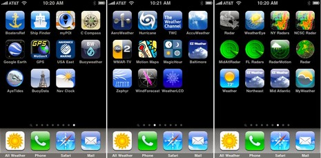
All Weather � Our favorite weather app (it�s a front-end for Weather Underground). As we cruise about, it selects it�s location based on our current location (it also saves previous locations) for forecasts, current conditions, alerts, and a good radar display (clutter removed). It also gives access to NOAA�s forecasts in a much more easily readable font than NOAA�s. It also plays NOAA weather radio. Steve Parker makes a bunch of good weather apps.
BoatersRef � Useful for looking up things like you might find in Chapman�s. More compact and more easily searchable than the paper version.
Ship Finder � Already covered in Panbo. We use it to get a wider area overview than the on-board AIS.
myPOI � A quick way to let the family and friends know exactly where we are.
C Compass � Already covered on Panbo. Since the iPhone is always with us, it�s a simple way to get directions (or find our way back to the boat when we�re on land).
Google Earth � It can be helpful to see the layout of an unfamiliar marina.
MotionX-GPS � We use this to record our track and then easily post it to our blog.
Navionics USA East � Useful for planning purposes and when exploring in the dinghy (with iPhone in waterproof case).
Buoyweather � Gives waves and wind forecast 7 days out for off shore locations. Gives lots of other data and predictions also. We use this a lot.
Aye Tides � Tides and currents.
BuoyData � Plots the nearest NOAA instrumented buoys on a map and allows selection for reading the current data at that buoy.
Nav Clock � This app automatically selects the current location and displays a page of current conditions � local time, UTC, day of week, lat/lon, temp, etc. This is also one of only two apps we know of that give both the barometric pressure and the trend.
AeroWeather � Displays aviation-focused current weather and forecasts for pilots.
Hurricane � Front-end app for NOAA�s Hurricane Center
TWC � The Weather Channel app � videos are also helpful (as in no TV needed).
AccuWeather � As the Weather Channel above, but different presentation. Also has videos.
Motion Maps � Nice overview map of entire US with a variety of overlays � Surface, Temps, Heat Index, Jet, Dew Point, etc.
MagicHour � Displays sunrise, sunset, various twilight times, lunar info, and daylight times.
Zephyr � Displays the current wind data for closest NOAA reporting location.
WindForecast � Provides wind speed and direction forecast based on a weighted average of the closest four NOAA reporting stations up to four days ahead.
Radar � This is for Canadian radar.
WeatherEye � This is the Canadian version of the Weather Channel. They also have video forecasts.
NY Radars, NCSC Radars, MidAtlRadar, FL Radars, RadarMotion, Radar � Provides access to the local radars.
EX Weather Northeast, Mid Atlantic, Southeast US � Similar to Motion Maps, except it�s a regional map with overlays.
Pano � Provides capability to make panoramic photos with the iPhone camera.
Clinometer � Provides a bubble-level tool, which is handy for balancing fuel between two tanks.
Wind Meter � A hand-held app for physically measuring the wind speed and yes, it really works.
What�s On? � When you�re in a marina that provides free cable TV, they often don�t have any kind of guide of what�s on (or even what channels are what). This app will show the schedule of what�s on. Also works for over-the-air TV.
Mango, Yelp, Cab4me � When in an unknown port town, these apps are helpful for finding stores, restaurants, and taxis.
Whoops – small typo above – it should be EZ Weather, not EX Weather. Nick
Kinda related for some of us: Navionics just introduced a neat looking Mobile Ski app for the Alps, U.S. edition coming 12/29:
http://www.navionics.com/MobileSkiFeatures.asp
I haven’t tried it yet but Theodolite looks really useful and cool. It overlays real time info about position, altitude, bearing and horizontal and vertical inclination on the iPhone’s live camera image.
After a reluctant step up from my (proven) waterproof GZ-One I’m using a Droid. It’s gonna be a while before I’m completely comfortable with this little wonder, but its already apparent that it will take a good bit of digging to separate fact from hype in the Ad War raging between ATT and Verizon. I’m stunned by the variety of Apps already available for the Android operating system (available on a large number of different phones) which, as on the iPhone range from stunning to trite.
All I can contribute at this point is this: I have not lost signal yet, from Annapolis to Miami to Dallas. Not once. It works inside buildings, and inside a shipping container! For that I have NO explaination. Google Earth NC is in Beta for the Droid. In a number of places, a (satellite) picture is worth a lot more than an 1895 survey on a chart!
I think that all the debate over which network is better is just a lot of media hype. Both are very good networks and are pretty much the same. Here is a study recently completed that proves this.
Gizmodo has completed a 12-city test of 3G cellular bandwidth speed. Verizon won four of the twelve, however AT&T scored higher with six: ‘Let’s get this straight right away: We didn’t test dropped voice calls, we didn’t test customer service, and we didn’t test map coverage by wandering around in the boonies. We tested the ability of the networks to deliver 3G data in and around cities, including both concrete canyons and picket-fenced ‘burbs. And while every 3G network gave us troubles on occasion, AT&T’s wasn’t measurably more or less reliable than Verizon’s.
http://gizmodo.com/5428343/our-2009-12+city-3g-data-mega-test-att-won
We have started porting our Nav applications to the iPhone. The portability of really makes an ideal platform for navigation computers.
You might take a look at http://www.starpilotllc.com for more info. Our nautical almanac reference (iNA) was release to the iTunes store about 6 weeks ago. Our StarPilot application is expected to be out late 1Q 2010.
And… this software does not have issues at the poles since it does not use the GPS!
Take care.
I really do not need another phone. All ready have a Blackberry (AT & T cell coverage).
What do I really miss with all the programs that are being talked about here, just using and i-Touch?
Ocean Rose has a Verizon wireless Wi-Fi signal thru out the boat. High outside antenna, with Wilson amp into a Cradelpoint router.
Bob Wilkins
Ocean Rose
KK 44 / 24
To add yet another app to the Iphone, I have heard rumors from some pretty reliable sources that Dozier’s Waterway Guides will soon be available as an Iphone app.
Hello Bob,
The ITouch does not have a GPS. So programs that depend on the gps (such as iNavX ) loose functionality when running on this platform.
We are still debating whether we will be adding GPS functionality to our applications. The current version of the nautical almanac does not use GPS. The current version of StarPilot does not either. Given that these programs are used for celestial navigation and conventional piloting the GPS is not necessary.
So… currently our applications run fine on an iPod touch.
Take care.
-luis
Luis Soltero, Ph.D., MCS
Director of Software Development, CTO
Global Marine Networks, LLC
StarPilot, LLC
Tel: 865-379-8723
Fax: 865-681-5017
E-Mail: [email protected]
Web: http://www.globalmarinenet.net
Web: http://www.starpilotllc.com
I wish there was an app for a usb gps for the ipod touch,seems to me it would be simple but there ain’t any yet anyway…stll waiting for dual’s gps cradle to come out.sigh
How about an iPod Touch Bluetooth GPS profile…how hard would that be? In fact, there is such a thing, but it requires jailbreaking the Touch and messing around with this:
http://www.roqy-bluetooth.net/roqyGPS.html
Come on, Apple, open up the Bluetooth on your phones and Touches, please.
Or there is this ..
http://gpscradle.dualav.com/cradle.html
iNavX will also support NMEA data over TCP/IP on iPod Touch and iPhone. So if one has a laptop on board they can have GPS (and instruments, AIS, etc.) repeated to iNavX.
hey gpsnavX…..you havn’t released your cradle yet like I said above.whens the release date?
GPSNavX has no affiliation with the Dual GPS Cradle for iPod Touch. Instead we produce marine navigation and weather software for OS X for Mac and iPhone/iPod Touch.
well your software is useless on an ipod unless you can hook up a gps ,right?You linked to duals website so I assumed you were affiliated.sorry.
I don’t think I want to jailbreak my Ipod touch..not yet too many issues like having to rejailbreak each time apple updates,etc.
I’m going to do a bit more research.
Peter, iNavX can get GPS and lots of other NMEA 0183 vessel data, AIS included, via WiFi. I tried it briefly on an iPod Touch, using Franson GPSGate to work the WiFi connection — worked fine — and Gram Schweikert uses that setup all the time with an iPhone:
http://vofj.blogspot.com/search/label/iNavX
I have used a great app for my BlackBerry to make things easier when I am lying at anchor.
It monitors the boats position and sounds an alarm if I drag outside the alarm area. It can even send alarms to other phones via SMS.
The benefit compared to having a normal anchor watch is that I can have it just next to the bed and I do not need to have the plotter on and consume power during the night.
http://www.MyAnchorWatch.com
Hello All,
Just a short note to let you all know that StarPilot for the iPhone and iTouch has been uploaded to the iTunes app store and should be available for purchase in a day or so.
You will find a full description of the product here
http://www.starpilotllc.com/products/spip.htm
and an independent review of the product here
http://criticalalpha.blogspot.com/2010/03/celestial-navigation-with-iphone-touch.html
Has anyone tried the app called “MID Wifi” (www.veerasolutions.com/midwifi)? I would like to hear opinions about it before I make my decison to buy it or not.
Based on where you are mounting it, do you believe your iPad is bright enough to be effective at this task? Lack of sunlight viewability is likely a show stopper for use above deck.