Garmin GNX 20/21 instrument displays, monochrome mashups
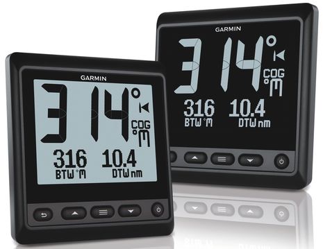 The press release for the new Garmin instruments doesn’t mention it — and I didn’t notice it at first myself — but can you see what’s quite unusual about these monochrome displays? The GNX 20 at left and its inverted GNX 21 sibling have LCD screens that are partly segmented and partly dot matrix. I didn’t even know that was possible, but I think it makes sense in terms of maximum power efficiency without completely surrendering to the readability limitations of large segments…
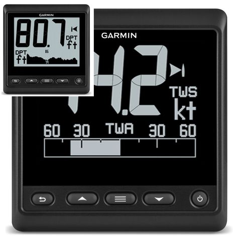
The GNX 21 true wind speed/angle screen above illustrates the segment/dot matrix mix pretty well, especially if you click to make it bigger, and the inset depth/depth graph does it even better, though I don’t have a high resolution version. The segmented upper left section of these screens display big numbers crisply, much like Furuno FI-50 Digital and Multi displays. But the Furuno’s can’t show a graph and sometimes even label text is a little hard to make out. By contrast, the all dot matrix Simrad IS20 Combi and Graphic displays are good at strip charts and small fonts, but not so great at large numbers. The Garmin GNX 20 and GNX 21 use both power efficient LCD display technologies.
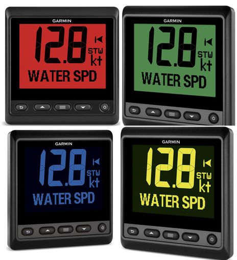
Garmin has also done something unusual with monochrome LCD backlighting, offering seven color choices and even the ability to custom mix them. Nonetheless, Garmin reports that the GNX displays only use .4 watt with mid level backlighting on and .35 during the day. And power efficiency — so important to sailors — is really what these $450 displays are about. A powerboater with plenty of spare amperage underway is apt to get a $550 all-color, any-graphic GMI 20 instead. Even big numbers look good on the new breed of all-in-one NMEA displays, as seen here, but they do use more juice (max on the GMI 20 is 2.5 W).
Powerboat may be the name of one set of data screens built into the GNX, but the other three are Sail Cruise, Sail Race, and Custom. I suspect the name change from GMI (Garmin Marine Instrument) to GNX (Garmin Nexus?) further signifies the sailing orientation. But Garmin didn’t have to do anything special on the backside to accommodate Nexus systems, as they already introduced the GND 10 Black Box Bridge last fall (along with GWind and lots of other stuff). So existing Nexus users can add GNX displays via that NMEA 2000 port, and like the GMI 20 there’s still an NMEA 0183 port for older sensors (though we’re at the point where that cable is an option).
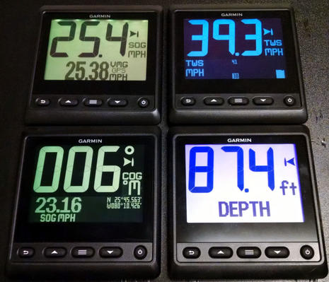
PS 12/19/2016: I made a mistake in the comments below, presuming that the GNX20/21 displays could not show large data fields like latitude and longitude. In fact, they can use either a small font as seen on the lower left GNX below, or in medium font like the one showing SOG MPH on the same screen, and they can do similar with many other data types you’ll find listed in the GNX20/21 user manual appendix.


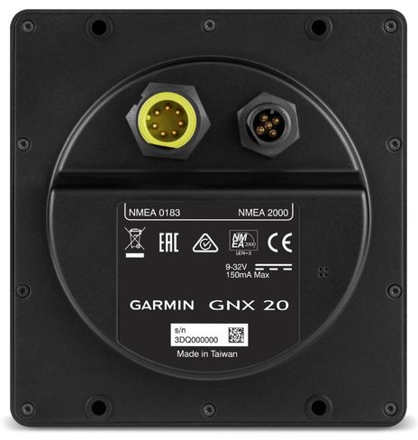



Interesting if low power is paramount. But does it draw .4 watt or 1.4 watt (see label)?
Also hope it resolves Garmin issues with handling of older versions of 0183.
From the press release linked at the top of the article:
If you’re getting 1.4 W from the 9 V × 150 mA listed on the back, that’s the maximum current for the device, and its typical draw will be less (much less if it does indeed consume only 400 mW).
Thanks Sparky and Joel! I didn’t notice the rear label “150mA Max” but, like Joel, I think that “Max” is the key word. The GNX 20 and 21 product pages make these claims repeatedly:
“Low power consumption (25 mA) with 350 mW (no backlight)/400 mW (mid-level backlight)”
“Power consumption: 0.35 W (day); 0.4 W (night)”
It could be that Garmin gave these displays a really bright High backlight setting.
I haven’t used either the Furuno FI-50 or Simrad IS20 monochrome LCDs in some time but I recall that their backlighting could have been brighter in certain twilight conditions. I’ve also noticed while testing screens with an accurate current meter that just a slight reduction from maximum brightness often results in a large power saving. In other words, the max draw of a device may not be a good way to judge its overall power performance, plus there may be times when you want the max.
Interesting device, and it would appear to be brand-agnostic, always a good thing – it looks like I could install one in my RayMarine SeatalkNG system without a problem, just a special cable (and I bet I could make one myself..:-). That it should fit in a Raymarine instrument hole is also a plus..
My issue with them is that it is listing for pretty much the same price as the “street price” of an i70. Speaking of the i70, Ray rates it at “1.6 watts” or “132 ma” – actually less than the 150 ma maximum shown for the GNX units – and I know the i70 can be set VERY bright (and full color!) I am going to guess that the NMEA2K power is being fed to an internal voltage regulator, so I would think the “150 ma” would apply at ANY input voltage.
Any guesses what the “street price” of these will be once they hit the market?
Right, Hartley, but does an i70 use just .35W all day long? I don’t think so. That’s why maximum power ratings have limited value (though “typical” power draw ratings are mushy by definition).
In my experience all the NMEA 2000 do-anything instrument displays generally work fine with any N2K data source. But they can only have their software updated by an MFD of the same brand and they can usually only calibrate sensors of the same brand. (Garmin does have a neat N2K SD card updater but that’s an exception.)
Hi Ben,
I don’t know – but I may be able to find out next week – I’m finally getting back out to our boat in the land of Granola, and I think if I plug a SeatalkNG power cord straight into my i70, it will power up (tho it won’t display any data). So I’ll be able to measure how much it draws, and I’ll let you know. I have a feeling that the computation electronics doesn’t draw much in any of these, and that the display lighting is the majority power user here (but I could be wrong!).
I’ve been having a debate with myself over getting another i70 for the aft stateroom or maybe an a65 for the nav station and move my existing i70 aft(for about $200 more, I can watch the radar, too!) – decisions, decisions..:)
A low-power/relatively inexpensive N2K data readout device would be nice!
Hartley, I think you’ll find that a blue STng power cord will not plug into a white STng device port, only into a blue STng backbone cable connector. It’s one of the ways Raymarine made STng especially hard to mess up.
Besides, the best way to do what you want is to jury rig a spur/drop cable so you can measure current flow to a specific device running on a real network. However you do it, I think you’ll find that the LCD color displays, though backlit by LED, take more power to be visible than monochrome, especially segmented monochrome.
OK, you made me look..:-)
The power connection to the STng network is either via the autopilot interface box (which I don’t use, because I want to be able to turn the autopilot breaker off without killing the network) or via a black w/red stripe power cable that plugs into a spur connection. The Ray manual for STng shows this clearly (they show a single “T” for this, but the 5-port bridge works the same way).
On my boat, I had a 5a breaker feeding the olde ST60 system, and I connected that wire to the 12V leads in the ST – STng cable (I cut off the 4-pin plug, as all I had were wires coming from the ST60 system anyway) I confirmed that this would work with Ray before I did it (via their forum).
I suspect I could use my extra power cable to power some low-current external device off the buss (assuming I wanted to attract Mr. Murphy really badly!).
You got me, Hartley! I stand corrected, and must have been thinking of the terminators, which can only plug into blue STng.
At any rate, I realize I have all the bits and pieces here to test the working power draw of i70 (and other N2K instruments). I just have to make up the cable with power breakout, which I’ll try to do this week.
@Joel. Thanks for your comments.
Yes I read all the materials. So under what conditions will the unit be drawing 150ma? Its on the label for a reason.
To my second point, when will Garmin fix the sw bugs re: handling of older 0183? You guys are unable to process RMC etc unless it contans the mode indicator added to later rev 0183. In constrast to my late model Standard Horizon VHF and other kit, which works just fine.
Not being able to handle RMC, a required minimum sentence, is IMO quite unfortunate.
Sparky, the reason almost every electrical device lists a maximum current draw is so that the power wire and circuit protection can be sized correctly. In the case of an NMEA 2000 device like this, the max current (LEN) rating is used to make sure there won’t be too much voltage drop in the network.
I’m pretty sure that the GNX displays only hit their max draw when the backlighting is at it highest setting. As I already mentioned above the current draw difference between high brightness and medium or even medium high can be quite significant. That’s why there’s often a big difference between max draw and typical draw.
Also, I’m not sure why you presume that Joel works for Garmin as I see no evidence of that. (It’s fine, incidentally, for manufacturers to post comments on Panbo, but please identify your affiliation.)
Even at a max of 1.4 watts, that is much less than the 2.5 watt max of the GMI 10/20. Typical power draw also seems to be 25% of the GMI 10/20
BTW no presumption made … Mr. Google reveals all.
To be clear, I do work for Garmin but I have no involvement in this product (nor would I be able to say anything that the press release hadn’t if I did). I simply saw Sparky’s comment and thought I’d try to clear up some confusion about general electrical terms.
Easy question – hopefully. Can the GNX20 display position data? I want to replace an old separate NMEA 0183 plotter at the chart table with a simple display that can show more-or-less any data from my NMEA2000 network – I’m hoping the GNX20 is that display.
I doubt it, Neil, because the GNX20 uses a partially segmented display to efficiently show up to 3 large digits (plus a dot matrix area to add a little detailing). It is not meant to display all N2K data types.
I think you want to look at the GMI20 or any of the other all-in-one N2K instrument displays that use a full resolution LCD screen:
https://buy.garmin.com/en-US/US/on-the-water/sailing/instruments/gmi-20-marine-instrument/prod126694.html
OK, thanks – a pity. All I’m trying to do is to replace the aged and bulky raystar ‘plotter’ with something that displays GPS position and speed at the chart table – I don’t need anything too complicated (or expensive!)
Neil, you might like the $149 Yacht Devices N2K display:
http://www.yachtd.com/products/display.html
thank you Ben – looks ideal
Woops! I made a wrong presumption about the data display capabilities of the GNX20 (and 21, and the bigger GNX120/130 displays). They can display Lat/Long Positions. In fact, they can use either a medium or small font to put Lat/Long in the lower dot matrix area of the screens — see PS image above — and they can do similar with many other data types. See the GNX20/21 user manual appendix for a list of the many data fields supported:
http://static.garmin.com/pumac/GNX_20_21_OM_EN.pdf