
NV-Charts app, plus MyNOAACharts & PDFs
 NOAA’s Office of Coast Survey has been making news. We were just discussing changes to the Magenta Line on ICW charts when a reader (thanks, Collin) caught the announcement that OCS will stop printing traditional paper charts next April, which even got on NPR national radio. Charts lithographically printed on heavy paper are a beautiful technology and it hurts a bit to see them go, but I’m not sure it makes much practical difference. Personally, I haven’t purchased one in a long time (nor do I ever throw them away) and I guess the mandatory carriage commercial vessels will do fine with print-on-demand charts and/or slowly proliferating ECDIS systems. At any rate, it seems like a good time to discuss how nicely the NV-Charts paper/digital package has evolved and also, the new ways that NOAA is distributing its cartography…
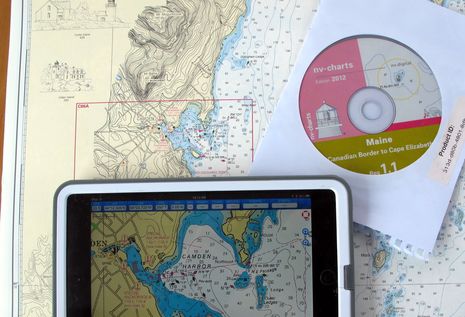
 I’ve written before about NV’s chart booklet and CD combos (and also about the raster chart cards NV makes for Navico plotters), but this season I’ve been testing the NV Charts app they’re giving to all current chart pack customers and also selling standalone. It’s available for Android, iOS, and Windows 8, and I’m pleased to report that once I registered myself and input the code for the Region 1 chart CD (seen in the top photo), the NV app on all three platforms let me easily download the charts. So, for about $70, I’ve got a regional set of nicely enhanced paper charts with their digital equivalent running on the boat’s PC (via the CD and Coastal Explorer 2011), an iPad mini, a Nexus 7, and an Asus Windows 8 laptop. Wow!
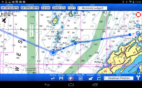 The NV app looks and works about the same on all three touchscreen platforms, and it’s not just a chart viewer. Its route building features are fairly extensive, and it even tries to automatically name waypoints appropriately, as can be seen near the McIntosh Ledge nav aid above (this nuance apparently not available yet in the Win 8 edition). You can also annotate waypoints with notes and create log entries, though I haven’t yet seen a way to export or share any of this data.
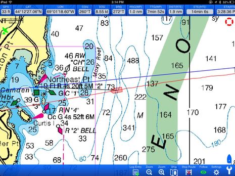 When underway, the NV Charts app delivers pretty much all the GPS and waypoint info you’d typically want. At certain zoom levels the charts look a little pixelated and I have seen all three versions of the app crash at some point, but still…if your main goal is to have some decent paper charts on board, this is a very nice bonus, and no doubt, the app will get better over time. The familiar and popular MapTech ChartKits are also a good alternative to the charts NOAA won’t be printing anymore, but the company must be concerned with the NV competition (compare the larger coverage area ChartKits with NV bundles).
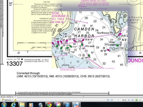
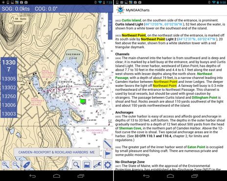 Meanwhile, NOAA has two new ways to give away the raster chart files that will no longer see a lithographic press. One is MyNOAACharts, a free Android app that also lets you download and search U.S. Coast Pilots. It’s still purportedly in Beta and may not be available soon, but it’s running quite reliably on my Nexus 7 (which makes sense, as it seems to be a version of MX Mariner). And just this week NOAA began a three-month trial offering of chart PDFs. The sample I downloaded and snipped below indicates how up-to-date and sharp looking they are.
But I did make a point of searching out Northeast Pt. for the screenshots because the latest edition of chart 13307 means that all scales now show the point as an island, despite my efforts to keep it as it was (as seen in the opening photo). Plus, you can see that the misplaced channel buoys I whined about in 2010 still aren’t fixed yet (and the mistakes have now been replicated on most every electronic chart). I love you, NOAA, I really do, and I’m fine with all your changes in chart distribution, but I do wish that the data update process was somehow more flexible and faster.


Jeff Siegel of Active Captain makes some good points about why paper charts aren’t as good a backup as some may think, while also inviting a spirited eBoatCard discussion by calling them “The second most dangerous thing onboard”:
https://activecaptain.com/newsletters/2013-10-23.php
I haven’t purchased a NOAA paper chart since 2000, when we went to Hawaii in the Pac Cup and I bought one that covered the Eastern half of the Pacific Ocean. It wasn’t useful for navigation, but it was very useful as a plot of where we were every day, and it has a place of honor on the wall today.
I did buy a chart book of NorCal in 2006, and I think I’ve used it once. I doubt I’ll buy any more, but it’s possible, I guess.
Why doesn’t NOAA just link up with Active Captain to collect crowd sourced chart corrections. Most of what is contributed to Active Captain is confirmed by multiple mariners which raises the reliability of the correction.
Will the NOAA electronic charts be available in vector format anytime soon, or forever raster?
Some of us (me) are hooked on a course-up plotter view and don’t read well upside down or sideways.
Richard: NOAA charts are available in both raster and vector formats. The SEAiq Free app on Apple iPhones/iPads will download both formats and allow you to switch back and forth between them. It also supports the US Army Corps of Engineers charts for inland waterways, which are also published online for free.
Karl, NOAA has been offering free vector ENCs (Electronic Navigation Charts) for some time:
http://www.nauticalcharts.noaa.gov/mcd/enc/
They have not yet converted every RNC (Raster Navigation Chart) to ENC, but they’re getting close. Numerous charting programs can display them (there’s a list linked to the page above). But be careful with them, because I think they’re often harder to read than the equivalent RNC or paper version. It’s great that the numbers and text are always right side up but that also means that algorythms instead of human cartographers are drawing what you see. Once example of the possible issues here:
https://panbo.com/archives/2010/06/alliance_for_safe_navigation_chart_reality_questions.html
No ENCs for my waters…and think it could be a long wait.
For recreational boaters who still want to have a hardcopy of updated charts onboard, NOAA also offers free Booklet Charts, which you can easily print off your home computer: http://www.nauticalcharts.noaa.gov/staff/BookletChart.html
The NOAA booklet charts are interesting, but keep in mind they are printed at a reduced scale from the originals. (Some commercial chartbooks, like mine, reproduce the charts at the full, original scale.) Also, the NOAA booklets are created by just cutting up the area of the original chart into equal portions in order to allow them to be printed out on standard paper and home printers. The result often chops the original chart very awkwardly for onboard use. It is possible to tape the various pieces together to create a larger chart, but you still have a reduced scale. Even when using a chartplotter, I find it very useful to have a full-size chart of the area in order to get the “big picture” of what is going on without having to continuously zoom in and out.
I have been printing out th3 NOAA raster charts for some time (I still do feel more comfortable with paper charts aboard). It takes Photoshop, a plug-in that does not cost much from Sean Kahil at Apocgraphy, enough tech savvy to read the DPI from the header in the .KAP files, and a good-sized plotter (my 42″ works fine). It is the same machine that Oceangrafix stores use for plot-on-demand, although they may have a 48″.
It would not make a lot of sense to buy the plotter just for this, although when you consider that many of the DMA charts are also available on-line . .
But anyone with a friend in engineering or architecthre could probably do fine just for the cost of the paper.
I had been eagerly anticipating updating my East Coast & Bahamas paper chart library by acquiring NV’s elegant paper charts + electronic cartography for my B&G Zeus. Unfortunately they don’t package/sell the paper charts with their chartplotter cartridges; instead they want you also buy their CDs, to acquire the paper charts.
Since I refuse to pay twice for NV’s electronic cartography, I’m still using current C-Map in Coastal Explorer and searching for alternatives to NV. With Navionics & iNavx on my iPad, I really looked forward to seeing a third cartographic view on my Navico MFD. It’s disappointing that I can’t economically enjoy NV’s ‘paper + data’ marketing initiative just because I want the data on cartridges instead of CDs.
Don Parker
Don, have you tried contacting NV about your issue? I’m only guessing, but I suspect they might cut you some sort of deal as they don’t have a package that meets your needs.
Thanks for the tip, Michael, and good to see that the Apocgraphy plug-in will work in many imaging programs:
http://www.apocgraphy.com/bsbImport/default.htm
But let’s also note that most every reader out there can easily print out the new NOAA PDF files (while they last). That may be their main use.
John, I agree with you that paper charts are great for the “big picture” view. Human pan and zoom abilities are excellent. But then again you don’t really need up-to-date charts for thinking about the big picture (if you do your routing and underway nav electronically). Also, I’ve found that a fast PC and a bright 26″ HD screen do the job pretty darn well:
https://panbo.com/archives/2011/07/charttable21_coming_together_thank_you.html
But that’s just me. Your ICW Chartbooks look great:
http://www.amazon.com/John-Kettlewell/e/B0034PYFPO
Not many of us have that “bright 26″ HD screen,” which makes it close to the size of a Chart Kit page, but what does it do to your night vision?
John, I don’t use it while underway at night, and rarely when underway during the day. It’s fastened to the underside of the chart table, which used to fold up to access a paper chart compartment. Now I fold the screen up for work, entertainment or route planning. I’ve been meaning to write an entry about the install because it’s worked out very well. I use screens nearer the helms when underway, screens that can dim to black.
Also that Chartbook-size screen cost a reasonable $350 two years ago, has held up fine on Gizmo, and only uses about 50 watts 12v using an efficient inverter.
Yes, the new pdfs are a great addition — I wish they had been there a couple years ago. Now anyone with access to a 36″ plotter can have all the US charts he wants.
Let us know if you get anywhere with NV on a data card/chartbook package price. I asked back in June when the new data card version became available and was told no bundle pricing is available.
Of course, I am still waiting for Simrad to issue the software update that will allow me to use the C-Map Max card I bought for an NSE plotter. A Navico rep told me in February at the Miami boat show that it would be released in March, but there is still no sign of it.
The NV cards do work, as I established using their demo files.
Richard C suggests that NOAA links up with Active Captain for crowd sourced data. I sincerely hope that never ever happens, not with AC, not with any crowd sourced information.
Why?
In my work as a writer for Waterway Guides, I look at every conceivable source of information, including Active Captain. At least 50% of the anchorage and passages information I find in the regions I write on is inaccurate, and at least 20% of that is dangerously wrong. Dangerous as in, it could sink your boat if you follow it.
The problem is not Active Captain, nor is it crowdsourcing. It’s the simple fact that most boaters are not competent enough to know EXACTLY where they are, or how to evaluate what they are observing. Without knowing that information, what they report is close to useless.
When you can find links for the exact same location that are diametrically opposite – how are you supposed to know what to trust, what is right and what is wrong? You cannot, so you’re back to making your own observations and decisions.
That being said, the ARGUS platform being used on Salty Southeast Cruisers Net, which provides depth and location information without human input or interpretation seems to be a much wiser choice if NOAA has to partner with anyone.
Thanks, Wally, but I disagree with your assessment of AC information accuracy. As Richard noted it’s often collaborated by multiple AC commenters, and I don’t recall ever seeing a major sink-your-boat mistake myself.
I’ve also seen valuable information in Navionics community edits and other spots, and I tend to think that most boaters who go to the trouble to share information have pretty darn good idea where they are.
Mind you that I never completely trust any source, including NOAA and the professional guides that I also find useful.
Ben, I could provide dozens of examples of my own regarding the inaccuracies of AC information, but the following post from an AC supporter on the AGLCA forum should suffice to make my point:
“”I have been a raging fan of ActiveCaptain since it started. We’ve shared information and watched it grow. It is ONE of the resources we use while cruising. It is not perfect, as you will find by reading reviews. Some users
will tell you to ignore the comments because after over interpreting them, they ran aground. There are reviews posted in the wrong place. There is out of date information. Any time you have a user generated database, you are going to have some user issues. AC has users with extremely diverse boats, boating experience and related opinions….. A two foot draft catamaran vs a 7 ft draft sailboat, for example, are going to see things differently.”
After writing the above, I’ve just pulled into an anchorage, Inlet Creek near Charleston. Most recent review on AC says “Avoid shoal on east side of entrance”, next review says “favor east side of channel when entering……almost ran aground on west side of entrance”. My interpretation? Better stay in the middle! Slow down and watch that
depth!”
Ben, I can show you reviews that advise anchorage X is wonderful – and then show you a post from the same person who damaged his boat leaving said anchorage, despite lifting his outdrives to a draft of 2’9″.
My own review, in Waterway Guide, of that anchorage clearly states that it is not to be used due to a Volkswagen Beetle sized rock in the middle of the channel.
When I want information, AC is not a site that I look to for accuracy, given the source. It’s not the site or even its design, it’s that the people posting do not have the kind of knowledge and training to make professional assessments.
Wally,
As a writer for Waterway Guide It seems you are in direct competition with any crowd sourcing publication. I’m really surprised that Waterway Guide thinks its customers “are not competent enough to know EXACTLY where they are, or how to evaluate what they are observing” That’s really a shame you view us like that.
Personally, I always respect “local Knowledge” especially when a Maine lobsterman motors up along side and says in his New England accent, “I wouldn’t anchor there”. Well, ActiveCaptain, to me, is that lobsterman who gives me a tip-off on something a first time visitor wouldn’t necessarily know about.
ActiveCaptain is not concrete, it’s a fluid fund of local knowledge and first hand experience, handed down in an electronic form. It should be added to what the chart says, what you see and what others tell you and then taken into consideration. If you are looking for reason why Waterway Guide shouldn’t join the paper charts I just took off the boat then mining AC for errors is going to be a futile pastime. Crowd sourcing is here to stay; you might want to help make it better. Go ahead, post some corrections on AC, we’ll be very happy you did.
got the mynoaa app on a tablet.cant seem to install charts..it says they are downloding and than when done still says not installed any help??
Sorry, anon, but don’t know what’s happening for you. I just downloaded a new area on a Galaxy Nexus 7 and it worked fine. The area is now listed as “installed” on the region list and the charts show up in Chart View mode.
More good chart news from NOAA. They plan to increase raster chart resolution from 254 dots per inch to 400 dpi:
http://noaacoastsurvey.wordpress.com/2013/10/29/better-nautical-chart-images-coming-to-electronic-charting-systems/
Thanks to GPSNavX for the tip!
Don,
Please send a message to [email protected]
And mention your product ID.
I am sure we could find a good way for your desired combination.
With kind regards,
Jeppe, nv charts.
Jeppe —
I had the same issue as you may see from post above. I wanted get a bundle of the US east coast north and the Region 3 paper chartbook but there is no such thing.