Category: Charts

Computer-assisted groundings? Bad Navionics charts? 32

Computer-assisted groundings? Bad Navionics charts?

Potts_Harbor_grounding_aPanbo.jpg

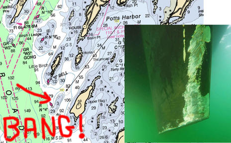
Despite incredible advances in chart availability and chart plotting, keels keep banging on reasonably well charted ledges and reefs all over the planet. Why? I’ve made far too many navigation errors to play the righteous scold, but I am taken aback by the tendency of boaters to blame technology and especially the recent trend toward castigating chart manufacturers like Navionics as if perfect data is a possibility or even an entitlement…

Is it true news that “NOAA wants to stop making NOAA charts”? 23

Is it true news that “NOAA wants to stop making NOAA charts”?

Landfall_email_NOAA_Wants_to_Stop_Making_NOAA_Charts_cPanbo.jpg

I’m a longtime fan of Landfall Navigation and I’m sure their intentions were good when they emailed this call to action Friday afternoon. But please don’t file a comment or call your congressman without looking deeper into the “news” that NOAA plans to discontinue all (paper-chart-like) raster files. In my read the end of rasters is only a far future possibility suggested in a recently published National Charting Plan that has some real meat (discussed below), and I’d be flabbergasted if it happened soon, or ever at the expense of important chart detail. Let’s judge NOAA on facts, not fearful conjecture…

Garmin acquires ActiveCaptain, now what? 29

Garmin acquires ActiveCaptain, now what?

Garmin_buys_ActiveCaptain_5-11-2017.JPG

This morning Garmin purchased ActiveCaptain and I have no idea if that will turn out to be good news or otherwise. Will this large and growing database of crowdsourced cruising information change now that it belongs to a major electronics brand? I have no bold opinions but I do have lots of questions I hope to discuss…

Cartography lessons learned searching for the best charts of Cuba 9

Cartography lessons learned searching for the best charts of Cuba

GEOCUBA_Cienfuegos_1-25000_chart_snips_aPanbo.jpg

Pardon my photography, but the point is that many detailed, up-to-date, and well-crafted official paper charts of Cuba do exist. Unfortunately, they’re not easy to own and the good work of the Cuban hydrographic service is also not yet fully available in any electronic form. In fact, many “current” electronic Cuba charts are based on shockingly old data with substantial chunks of critical cruising detail missing. But visiting boaters do have at least one good current chart choice – GeoCuba is moving into the modern world, and the back story reveals chart issues every navigator should understand, with a Cuban twist…

A Camden boat grounding dissected, can crowdsourcing help? 23

A Camden boat grounding dissected, can crowdsourcing help?

aground_in_Camden_mooring_field_blurred_cPanbo.jpgThe identities of the yacht and its operators are irrelevant. But how did they go hard aground in a highly used harbor during a clear summer day? Was it just a dumb mistake or was a lack of chart detail partially to blame? Should the USCG or the town of Camden better mark the danger? Did marine electronics somehow contribute to what was at least an embarrassing incident? Can crowdsourced data help? I’m not sure about the answers but I have assembled a lot of information for discussion…

NOAA introduces Zones of Confidence; mind your ZOC 6

NOAA introduces Zones of Confidence; mind your ZOC

NOAA_chart_18622_w_new_ZOC_table_cPanbo.jpg

Yikes! Did you know that some areas of the U.S. coastal chart you’re using may only show land and bottom features accurate in position to +/- 1,600 feet, and you shouldn’t be confident about the depth soundings either? NOAA has a new way to show boaters how old and inaccurate much of its survey data is, and it will surely give pause to those who pay attention. The concept is called Zones of Confidence and it’s slowly rolling out as diagrams on paper-style raster charts like the one above, but the ZOC accuracy info is coming much faster to NOAA’s ENC vector charts, and apparently it could be made easily accessible on the commercial vector charts you’re probably using.

TBF: Modeling NY40 Marilee, Weems & Plath magnifier & young Mr. Harding 5

TBF: Modeling NY40 Marilee, Weems & Plath magnifier & young Mr. Harding

Stephens_Waring_proposed_Marilee_design_aPanbo.jpg(Bits are back, if you know what I mean.) I skim a lot of email newsletters but this recent Stephens Waring Yacht Design creation brought the process to a quiet halt. I clicked up this image as big as possible and became mesmerized, and it later turned out that even the newsletter text is only a sketch of the bigger story. Before we get into that, I suggest you get mesmerized, and I snagged even higher resolution images. Clicking them big may be slow, but you should be getting yourself stilled and ready to simpy wonder…

ACR GlobalFix V4, NavPod, Stealth PC, Raymarine r16, and MFD ActiveCaptain via C-Map & Furuno 17

ACR GlobalFix V4, NavPod, Stealth PC, Raymarine r16, and MFD ActiveCaptain via C-Map & Furuno

ACR GlobalFix V4 EPIRBAt long last an ACR Emergency Position Indicating Radio Beacon (EPIRB) with a 10 year user replaceable battery! Moreover, the new GlobalFIX V4 is exceptionally compact and handsomely designed — which also may relate to its 2015 acquisition of Ocean Signal — and of course it includes standard EPIRB features. The $150 batteries aren’t cheap, but it may beat tossing a working GlobalFIX V4 that retails for $400 (manual activation, with automatic at $500).

Flash: C-Map and Navico become sister companies 18

Flash: C-Map and Navico become sister companies

Boeing_sells_C-Map_to_Altor_(Navico)_aPanbo.jpgHere’s some big news in the small world of marine electronics. Boeing company Jeppesen just sold its marine cartography division to a formerly unknown entity named Digital Marine Solutions (DMS) and it “will trade under the C-Map brand name” (as it did before Jeppesen came along and as many of us could never stop calling it). DMS belongs to the Nordic based Altor “family of private equity funds” which also owns the Navico family of Lowrance, B&G, Simrad, and GoFree brands. Interesting?