
Raymarine LightHouse R17 part 2: hands-on Navionics Dock-to-dock, SonarChart Live & more
When Raymarine’s significant LightHouse software Release 17 became public last Thursday, I’d already had a chance to test a beta R17 version on the water and was able to discuss the new global weather display feature along with the LightHouse WiFi capabilities that can make weather data access fairly easy. In this part 2 entry, I’ll share my experiences with the new Navionics SonarChart Live display and Dock-to-dock Autorouting, and also discuss R17’s new NMEA 2000 Audio app and other improvements…
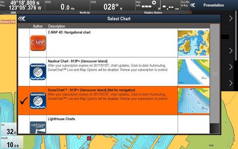
It’s important to understand that you need a Navionics chart card with a current Freshest Data subscription in order to use SonarChart Live and the vastly improved autorouting (as warned about above). In fact, you probably need to update the data on your card to get the charts that work with Dock-to-dock as well as the correct “eligibility file” (and looking at your card with the Navionics Chart Installer program is a another way to check your subscription status).
By the way, the charts on an expired Navionics card will still work for all other tasks, and the original Navionics autorouting will continue to work on Ray MFDs until the end of 2016. But as seen on Journey’s Raymarine c125 above, I did have the right card to test the new Navionics features during my first cruise of the season.
SonarChart Live
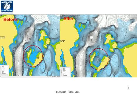
Let’s recall that while SonarCharts have been available on the Navionics Boating app and on some multifunction displays for a while, Raymarine was first to integrate with the app so that sonar logs collected on an MFD can be easily added to the public charts. That’s how Ben helped chart the Barred Island anchorage above in 2014.
Later the Navionics app got SonarChart Live (SCL), which meant a tablet and smartphone with depth input could paint rough raw data bathy maps in real time and even more easily upload them to Navionics for further processing into the master SonarChart database. Ben tested SCL using a Vexilar WiFi fishfinder, and his iPad mini screens above show how the raw Live data differed from the existing SonarChart (which was later improved with his data).
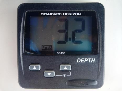 My depth sounder is a basic but reliable Standard Horizon DS150 with a thru-hull transducer and the ability to output NMEA 0183 depth data, which I have multiplexed to my c125 MFD along with AIS and DSC data. Strangely, it only outputs data when the SH display is set to show depth in meters. But SonarChart Live can purportedly use any depth input the Ray display sees, and it seemed to work fine in my testing.
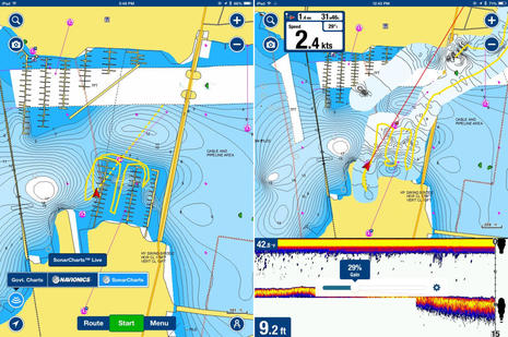
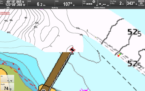
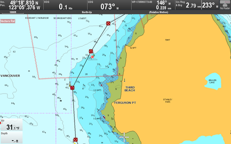
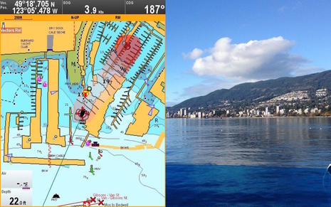 You can see SonarChart Live guesstimating a bottom contour swath as I took Journey out of my Mosquito Creek Marina slip on Vancouver Harbor’s North Shore and headed west under the Lions Gate Bridge to the mouth of the Capilano River (Google Map here). Though it’s a popular coho salmon fishing area, the season hadn’t begun and I pretty much had the area seen above to myself on a beautiful day. Note how red is SonarChart Live’s default shading color to differentiate it from the regular chart or SonarChart blue shading it overlays, and the shading intensity is correlated to depth based on a user setting.
Since Ben tested SonarChart Live, the Navionics app has gotten the ability to correct the Live data for a nearby tide prediction station (as well as the transducer’s depth), and that’s also true in Raymarine’s implementation. So when I switched on Tide Correction in the Advanced Map Options menu, the data was corrected about 10.2 feet to show low tide soundings like regular charts.
You can also control SonarChart Live overlay opacity as shown on the smaller screen above (which was taken from the R17 New Features PDF). Notice how I was using little opacity — that is, lots of transparency — when leaving my marina so I could also see the underlying charted depth bathymetry and the above water structure. By the time I took the screen below, I had turned the opacity up to 100%.
I guess I should not have been surprised when I measured the width of the SonarChart Live bathymetry swath at about 220 feet wide because it looks similar to what Ben saw on the app. In fact, according to Navionics a 50 meter swath is the standard convention for surveying that has been adopted by the industry including other depth collecting features like Navico Insight Genesis, Humminbird Autochart, and Garmin Quickdraw. There’s a lot of guesstimating going on — especially if you’re in shallow water with your transducer only seeing a narrow section of the bottom — but you can improve the accuracy a lot by making multiple passes. Plus, if you contribute your sonar logs to Navionics, the data will be rationalized with all other data collected in the same area.
Incidentally, most of my SCL data was collected at under 6 knots, but I did go up on plane to about 17 knots as I moved past the mouth of Capilano River (shown as the green low tide area in the bottom right of the screenshot chart above). SonarChart Live kept laying down contours no problem. You can see that the soundings I created were similar to the underlying chart values so I felt some assurance as to its accuracy.
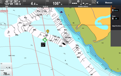
 Zooming in further on my return under the Lions Gate Bridge, you can see my parallel track joining up with my outbound readings. Since I’ve got the SCL overlay opacity setting cranked up to 100% here, it’s painting over chart features like the bridge. (The pixelation on the right was a sporadic screen rendering issue that may have been fixed between the LightHouse version 17.34 I tested and the public v17.45 version.)
Back at the dock the next step if you want to share your data is to either sync the Navionics app with the Raymarine MFD or take your chart card home and run it with Navionics Chart Installer program. Your data should be processed and added to the SonarChart community data within about a week, and it seems quite predictable that Raymarine will eventually make the upload process even easier using the MFD WiFi discussed in Part 1.
Overall I really like SonarChart Live. It is easy to use and I think most useful to create your own chart detail for fishing, diving or choosing the best anchoring spot.
Dock-to-dock Autorouting
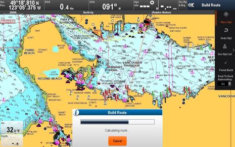
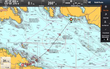
Turn on the Navionics Dock-to-dock Autorouting now in my Raymarine c125 Build Route menu, pick my start and end waypoints, and then wait for the route to magically build — that’s it!
There’s some history here. Almost two years ago in Lighthouse 11, Raymarine offered Navionics autorouting (if you were using a Navionics card) but I was underwhelmed by the results. By contrast, Navionics Dock-to-dock is a pretty amazing and award-winning replacement autorouting technology that Ben comprehensively explored when it came to the Navionics Boating app last December. The Raymarine version of Dock-to-dock in R17 was previewed last fall at METS and it may have taken this long to launch because it’s not a trivial feature.
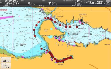 Here I’ve built my first route from just outside my marina breakwater to the end of False Creek. This is a scenic 7.2 nautical mile trip that I often entertain guests with because of the protected sections at the start and finish. Navionics told me that the MFD software and Boating app algorithms are pretty much the same, and what you see on the chart is actually two routes overlaid on each other. I wanted to see if my MFD would calculate the same 43 waypoint route as the iPad, and it did exactly.
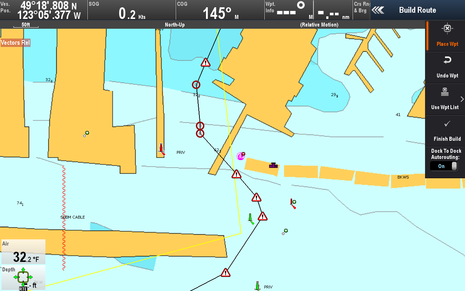
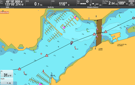 Here’s a closer look at the end of fairly narrow False Creek as you move under the Cambie Bridge. Note the triangular warning symbols used to mark waypoints. These are pretty liberally shown after autorouting calculations and are meant to warn you about dangers like shallow water or to check bridge heights. Dock-to-dock does not check your boat’s air height, but route calculation is very dependent on your minimum safe depth setting. (To avoid unwanted “Safe route could not be generated” messages, I did all my testing with this set at 5 feet.)
 Dock-to-dock did a great job respecting the lateral buoys near Cambie Bridge and elsewhere, but I didn’t like how it guided me east of the QC west cardinal buoy, which literally means “safe water is to the west of the buoy.” In this case cutting the corner a bit wouldn’t be a critical error but the route is too close to the rocks for my liking. Note that route editing is different on the Ray MFD than on the Navionics app. On the MFD you can manually edit waypoints (quicker with a touchscreen than non) but unlike the app, the MFD-based route won’t automatically re-calculate legs after a waypoint is moved.
Another Dock-to-dock difference from the Navionics app is that on a Raymarine MFD you can’t use a Point of Interest (POI) like a marina for a route start or end. You also won’t see a list of POIs around your destination or get an immediate trip distance, time and fuel burn (though those values are available on the MFD if you have the right data windows set up and the new route is selected). Hopefully Raymarine’s implementation of Dock-to-dock will catch up with the Boating app version, but I have some suggested improvements for that one too.
 For instance, it would be helpful to get a warning symbols when a Dock-to-dock route passes through a charted Traffic Separation Scheme. And perhaps I’m nitpicking but wouldn’t it be good to have warning symbols for this route that crosses the large “Whisky Golf” WG torpedo testing range near Vancouver and smack dab in the middle of the incredibly popular south-north route to Desolation Sound? I’ve skirted around WG during military testing and seen pleasure boats chased out of there. (Always check with Winchelsea control when passaging this hazardous area.)
There are also minor anomalies, like where Dock-to-dock becomes “dock-through-dock” at my Marina. This is a pretty obvious error that hopefully most boaters won’t fall for. As has been often discussed, no autorouting can be completely relied on. Think of Dock-to-dock as your junior navigator; it’s nice to have the help but you won’t trust them without checking their work!
Overall I’m pretty excited about Dock-to-dock. It is miles ahead of standard autorouting, it’s a huge time saver, and it’s great to have it on my Raymarine MFD.
C-Map ActiveCaptain
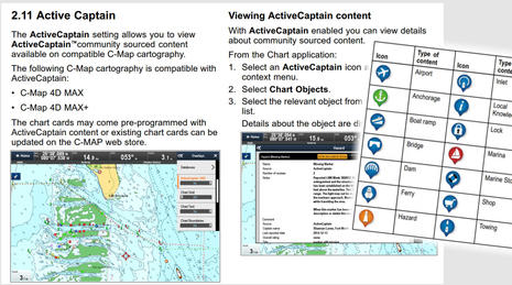
Of course Raymarine also supports C-Map cartography — right up to 4D-MAX+ — and with R17 that includes the ActiveCaptain cruising POI info that C-Map now adds to its chart cards. We discussed this and Furuno AC support on Panbo (bottom of entry), and here’s a good Ken Cirillo video on the subject. Judging from the LightHouse R17 New Features manual above, Ray is using a wider selection of POI icons than normally seen on ActiveCaptain displays, but so far it does not seem possible to filter them so that you only see the ones you want.
NMEA 2000 Audio App
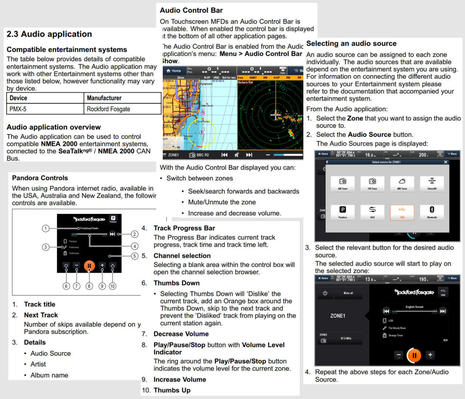
The new NMEA 2000 Audio app that comes with LightHouse R17 was foreshadowed when Raymarine announced MFD control for the Rockford Fosgate PMX-5 in February. Then Ben discussed how this and other N2K stereos might bring competition to the boat integration trailblazed for years by Fusion, though he was skeptical that it could be done as well just using NMEA’s new entertainment PGNs. Well, so far the Rockford Fosgate PMX-5 is only the stereo listed as fully compatible with the new LightHouse app, but Raymarine says it’s all done with the standard N2K message library and that other stereo manufacturers can follow suit.
The Audio app does looks quite complete — as seen in part by the snips from the R17 New Features PDF above — and it includes the PMX-5’s intriguing ability to use two different audio sources with different speakers zones on your boat. So Raymarine seems well prepared to work new N2K stereos announced by JL Audio and most recently by Prospec Electronics.
And don’t fret about Raymarine keeping up with new Fusion Entertainment marine stereos; LightHouse R17 also includes numerous updates to the Fusion-Link audio app, including support for new audio sources like MTP, DAB+, and built-in Bluetooth, as well as deeper zone controls and maintenance functions.
& more in R17
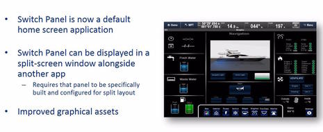
As shown in the slide above from Ray’s r17 powerpoint presentation, the LightHouse Switch Panel app is improved and now able to display in a split-screen window. Raymarine’s digital switching has become quite sophisticated as also described recently on Panbo, but its use is still largely limited to boat builders.
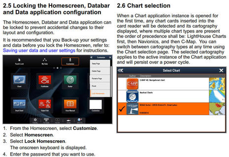
However, there’s also a new Homescreen and Databar Locking feature that will be appreciated by many boaters like me who enjoy letting crew use the electronics to a certain extent (or sometimes accidently mess things up by ourselves ;-). And LightHouse’s new ability to choose available chart types by itself even if you’ve switched or added cards sounds good for all.
These features are explained below in the New Features PDF, which is available in full here along with the 1GB R17 update. All in all, it’s a pretty remarkable free system update and we look forward to hearing how it works for you.


I have never seen my Garmin autoroute me through a dock.
It won’t even go through danger zones like the magnetic anomaly of of Small Point Maine. This will be interesting to compare the two systems.
Ben,
I was able to test out the dock to dock with navionics while in the British Virgin Islands. It performed really well!
At first, it told me that I was not supposed to be in the area of the harbor where I was starting. Then I found a setting to adjust the water depth to what was actually around me and bam, worked like a charm. I was aboard a shuttle boat traveling between two islands and with little exception, the route created, was virtually on par with the route the shuttle took!
Now I believe here is the reality, would you use Route to Route in your regular cruising areas? Probably not, or at least not often. However, if I am new to an area or a new boater, the route to route is a great tool. However, like any tool, it is to support your navigation, not BE your navigation.
Thanks, Allan, but I’ve seen Garmin autorouting do some odd things once in a while. The latest was nearly funny. In early April during the Garmin demos in Miami, I took this screenshot of Auto Guidance 3 in action:
https://panbo.com/assets_c/2016/04/Garmin_2016_auto_routing3_cPanbo-13264.html
Notice at the bottom of screen how the autoroute goes inside a Green Beacon marking the dredged channel. That’s not uncommon in most autorouting; so far only Dock-to-dock actually honors nav aids, and it messes up too, as Adam illustrated.
What was odd was that we tried multiple times to modify the Garmin autoroute, but every time it recalculated the route snapped back to that 6 foot spot just starboard of our boat when I captured the screen. The algorithms were absolutely insistent that the boat had to go over that area.
I believe that the Garmin folks saw it happen again on another demo cruise and reported it back to the cartography dept, and I didn’t mention it in that entry because I think such anomalies are quite rare.
I do know one in Maine, though. Try Garmin Auto Guidance from the WoodenBoat School anchorage to Center Harbor. It may be fixed by now, but instead of guiding you through the gut just north of the Torey Islands, though plenty deep, it insisted on going right over the ledge extending west of the Toreys and then around to the south.
I still used handy Garmin Auto Guidance a lot, just carefully 😉
I really love the frequency of updates and features that Raymarine is coming out with.
I had been using the autorouting feature on my eS78 for a while, and didn’t like the way it routed inside buoys and other nit picks (see https://www.sailbits.com/blog/2016/05/port-orchard-weekend/) so I’m glad to see they’ve spent some time on improving it. Will give it a try here in a few days.
I have a Fusion radio and am thrilled to see that Raymarine has updated their support for NMEA 2000 compliant radios. I can now see song details, change settings, and do everything else that I was able to do with my B&G and Garmin when they were connected to the Fusion / NMEA 2000 network.
Hopefully the Rockford Fosgate partnership doesn’t mean they will let this stagnate, although it’s pretty decent as it is.
I recently completed my marriage of a new Raymarine c125 to some older generation electronics and have yet to fully appreciate all the capability that I have. I did print off ‘selected’ chapters of the manual and in that process killed off a few trees, so someday while at anchor I’ll get a chance to read all the details. I like my new display and offer the following observations…
1. I am a believer in manually-adjusted radar Gain. In fact, I am convinced that Range and Gain are the two most used controls on the radar. The problem is that my new c125 display requires a button push + several twists + another button push to get to the Gain control. The important Gain control should never be more than one button push from the normal radar screen.
2. I was upset that Raymarine announced the Quantum solid state radar shortly after I was committed to the digital RD418 that the upgrade mandated I buy. Because of my past experience with solid state digital radar in aviation I am a believer in the technology, and I suspect that there are user benefits still to come that have barely been imagined by the engineers.
3. The brochure said it was supposed to be a 48 mile radar. I’ve been out of my slip only once since completing the install, but I was truly impressed when I saw the 11,249 ft peak of Mt Hood at a range of 41 nmi. My past experience with aviation radar convinced me that radar range was NOT so much about transmitter output power, so I’d make a guess that my old Raymarine analog 2kw radar would get very near that if only a digital interface were available for it. Nevertheless I’m waiting for someone to tell me what possible navigation benefit a 48 mile radar offers, given that the diameter of our planet is only 8,000 miles and not likely to change in the near future.
I can remember transiting the rather featureless (from a distance) Oregon coast and using the peaks of the Coast Range for fixing my position. I needed the 48 mi range then (well before GPS).
Is it possible to transfer newly generated Sonar charts made in the dingy on my iPad to my motherships Simrad NSS7 or NSS12? I plan on being in the Bahamas in a year and would like to have a system to do this that does not rely on the internet (wifi would be fine). Can I do this through the Simrad Gofree wifi?
i just performed the Lighthouse II update. seemed to work perfectly. but now my 2 year old e7 display is very slow to render charts, whether i am trying to move the cursor or change the zoom. impossibly slow.
so I did a full reset; then turned off the new Live Sonar (I have a navionics platinum+ subscription), turned down all the high-res features… still slow.
my system has worked superbly and I had the most recent update installed with excellent performance. all my i70s and my p70, STC, etc everything updated nicely but now I have a crippled chart system.
searching ray marine forums…
hard reboot again. works much better.
then selectively try reducing amount of data/detail/density charts and sonar package. with an hour of trial and error I found a combination that gives me fast rendering refresh of the chart.
I tested a Dock to Dock route building going to Mattituck inlet pond. anyone who has been there knows the torturous number of turns and shoal waters on the way to that beautiful pond. my e7 build the route in under 5 minutes, with 47 waypoints to cross the Long Island Sound and head up creek. there are 28 waypoints just to get through the Mattituck Creek. wow.
still haven’t gotten the Wifi to work, but the lay lines and race timers look beautiful as do the bottom contours.
Good to hear that R17 is working better for you now, Richard, and here’s hoping that other boaters don’t suffer from the update.
Incidentally, I’m not familiar with Mattituck Inlet but I found two searchable online chart sources I can link fellow readers to:
https://webapp.navionics.com/#search@15&key=%7BehyF%7CqxyL
https://activecaptain.com/X.php?lat=40.994735&lon=-72.539377&t=n&z=15
That is a skinny inlet, and if the SonarCharts shown on the Navionics site are correct, there seem to be some shallow spots…
Richard,
I have had some problems even on my fairly new (in the last year) eS78 with R16 and R17. In particular, because I have so many AIS targets, things get super slow at times. If I use Vector Charts (Lighthouse) with all detail, AIS targets, etc. I can actually cause the system to become completely unresponsive.
I have not yet documented it and opened an item with Raymarine. Sounds like there might be some optimization left to do on their end!
Ben, there are plenty of shallow spots on the inlet! I’ve gone through on half tide rising with my 5.3′ draft and never touched bottom. I was really impressed to see the Dock-to-Dock route through there. I used it Saturday to go from Milford to Black Rock Cove and it was great, right up to the point where a Bridgeport Police boat was blocking the way into Captains’ Cove for a kid race.
Anonymous
Can you limit the number of AIS targets by changing your Collision Avoidance parameters? I have a lot of boats around me at times, so I pull my warning zone in close. I also went through the settings and defaults, and found that High Detail was slowing me down (I have Navionics Platinum+), I also cut the amount of bottom contour way down. I am not using the system to fish so the least detailed bathyscape is still more than I had before. I found that Sonar Chart LIVE setting made no difference to my screen rendering so I left it on for now, but had so many other things to play with that I didn’t get it.
I had zero trouble with R16 update on my e7. if you had trouble starting with that update you might do a hard reset. the Update Instructions say it isn’t required unless you have run out of things to do to solve any problem. It helped a lot for me but took two times and waiting a bit for it to help me. I am guessing the first hard reboot did not propagate through my network, so it took two tries to reach all the devices and reset flags or ports. but I am just guessing
adding to this thread regarding new features on the LighthouseUpdate.
I used my system extensively during the past month, following routes under power, sailing to wind vane, checking tides and currents, logging depths and uploading/downloading via my Platinum+ Freshest Data account, AIS calls, DSC calls, even the automated foghorn got a work out.
my e7 works quite well and operates the Autopilot well. it still has the intermittent glitch of “loading up the processor” where suddenly the e7 takes 15-45 seconds to respond to a command (eg. change chart scale, set GoTo, check waypoint). the only fix for it is to power down and up — really inconvenient at times!
I loaded my boat’s Polar data but the e7 does not routinely show me the lay lines generated. the lay lines mostly appear when i am motoring to a waypoint (?!) but rarely when sailing.
VHF and AIS are still flukey — suspect the funky splitter which is part of the troublesome AIS250.
As usual the tech support from Raymarine is on par with the performance of their hardware.
More and more I wish I had replaced the system with Garmin or — anything other than Raymarine.