
Download high res historic charts
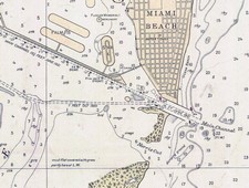 OK, I’m obsessed with charts, but I’m not the only navigator thus afflicted. Last week I used a snippet of a wonderful 1685 chart that’s available on the Net, and promised to tell more. The source is the U.S. Library of Congress Map Collection. The LOC has scanned scads of cartography at very high resolution for your viewing and downloading pleasure. You’ll see several categories, none of them “nautical charts” per se, but you’ll find all sorts once you dive into the search engine. Shown here, and larger here, is a bit of a 1921 chart of Miami. It’s interesting as an early example of color use, and also because it shows a Miami Harbor that’s damn shallow and missing some major features like Fisher Island and the whole cruise ship dock area.
You can zoom into the detail of these charts nicely on the LOC site, especially if you have a fast Web connection, but there’s a problem if you want to download one for further perusal or printing. Many are in an unusual format called MrSID that no standard graphic program I know of can read. The solution is IrfanView, an excellent freeware (or “beggar ware”) program created by a young Bosnian named Irfan Skiljan. IrganView can turn this 6.6 meg .sid file of Miami into a 90 meg .jpg file that would print nicely full size. The LOC offers some maps and charts for areas outside the U.S., but if there are richer sources I’d sure like to hear about them.


And what about NOAA’s collection of historical map and chart collection, at http://historicals.ncd.noaa.gov/historicals/histmap.asp? And with links to MrSID viewers!
Thanks, Bill. I forgot NOAA’s excellent site, which may in fact have been the source of the Miami chart.
Just a note about MrSID chart/map format. There is a shareware program called OziExplorer that can handle this format.If you are not familiar with this sofware, check it out at http://www.oziexplorer.com I use Ozi with my Maptech charts and find it a reasonable alternative to some of the high priced electronic charting systems on the market.
Thought you would like to know
Regards,
Vic
Thank you, Vic. Does that mean then that you can tell OziExplorer the coordinates of a .sid chart and navigate on it? I’m guessing, and hoping, that one day PC/plotter memory will be so abundant that historical charts will be included in navigation packages just for the fun of it!