
Garmin’s “Where To?”, what up?
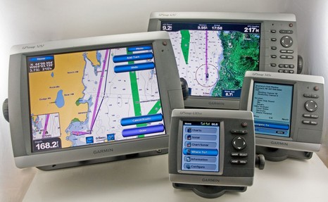
This photo, of which I’m especially proud (talk about herding cats!), is also a great example of how well Panbo can work with magazine articles. It’s the opener to my October electronics column, in which—thank you, PMY—I had the support to seriously ruminate about testing these four new Garmins. But here online I can show you the picture in greater detail, and write the long caption it deserves.
The goal, besides illustrating relative sizes, was to demo the Where To? button that appears on the Home menu of all the new Garmins, seen here on the little 430sx front and center. A major theme of the column is that Where To? is a truly fresh look at routing, and the beginning of the end, I think, for electronic route-building styles that are still rooted in pencil-on-paper navigation (and which many boaters resist using). If I’d had six units (yike!), I would have included the two screens below in the counter clockwise progression. Where To? takes you first to a choice of common destination types (lower left), then your choice generates a list or relevant possibilities ordered by distance from your present location. On the big picture you’ll see that I chose Journey’s End Marina and got back all sorts of info on it. (The 545’s screen is one of 4 available for that particular POI, including a zoomable chartlet, photos, and local weather if XM is on board. You gotta love a marina, by the way, that also sells bait by the tank.)
At any rate, if you decide that that’s where you want to go—the real first question of route planning—then you hit the Navigate To button). The screen isn’t shown but the choices are Go To for a simple straight line course/bearing to the destination or Route To, which puts you at the destination with a “rubber band” route line that you can work backwards to your location, key or finger tapping waypoints as needed. That process is shown in action on the 5212, but if you have a g2 Vision chart card in the plotter (or, as here, in the network), then you might instead choose the Guide To option, seen best on the 4212. Guide To uses the card’s bathy detail to figure out a “reasonable” (usually) route to the destination which it lays down as a purple road. As shown, it gives you distance to, and ETA at, the destination as you drive along it. But, if you want individual waypoints, or to drive an autopilot, you have have to add them rubber band style. It all works pretty nicely, and I’m sure will get better as Garmin continues to develop—you might say, “finish”—the software (another theme of the column). Finally, check out the little window on the left side of the 5212. If you finger drag (or cursor) the chart so that your boat is no longer visible, that little situational awareness chartlet pops up. A nice little (optional) feature I’ve never seen before. See how this caption would be hard to fit in a magazine! (Here’s a list of Garmin entries.)


This is great. The software can evolve so that all routing algorithms use “common” routes to and from popular places. This means that boaters who are likely to use this feature will be herded into predictable lanes, much like VTS.
The possibilities are endless – I can get one so I can know what routes to avoid (sooner or later this will be on charts?), Vessel Assist and the like can study common routes and pre-position themselves where groundings are likely, services can become established along common routes, floating latte stands! The future is near!
Great – just great. Two unsuspecting boaters have the machine plot reciprocal courses and meet head on in restricted visibility or at night.
I can’t wait.
All those nice new boats, with nice new owners, following popular routes- in BOTH directions. Should be lots of insurance write-offs for the rest of us to buy.
Anyone good at re-sharpening sharp ends!
In your testing of the 5212, have you found the touch points (icons that you are supposed to touch) to be somewhat out of place with where you actually must touch? We have just installed a 5212 for a client and I have noticed a problem in this area. There are a few other Version 1.0 issues with these that I am hopeful Garmin will fix quickly.
Geez, is it the full moon? Why so cranky, guys?
Garmin’s auto guidance will not steer anyone’s boat for them, OK! If anything its guidance might give boaters more time to look around and avoid problems. Today, most skippers do GoTos from spot to spot, or just muddle along eyeballing where their boat is on the plotter. (Though I’m sure you gents are all exceptions ;-).
Nor will Garmin machines create more boaters and/or more boaters on the same routes. The latter already happened when Maptech started printing major bouy waypoint info on ChartKits.
And the towing guys already know the money spots; heck, Capt. Rodriquez here put a lot on them on Google Earth as I recall.
Overall, yes, electronics have made it easier for people to get into boating, and some don’t know as much as they should. It’s going to get worse, too, as smart propulsions systems make it much easier to park a boat. Er, I mean dock.
But once you get through the “sonny, why I used to chew through two pencils getting to that island!” phase, don’t you want everyone out there in the fog with you to have as easy-to-use electronics as possible?
Oh, and the fact is the Garmin “Guide To” function often creates noticeably different routes from the same point to a destination, though I don’t think it’s a feature. Where you’ll find really precise routes that are closely followed is in some of C-Map’s professional charting products. And I’ll bet you’re glad that they are closely followed.
This is nice stuff. For me it begs one question and prompts a feature request for another.
The first is whether this is easier to use than the same functionality on a PC/Mac. With access to the same data, I have to believe that a better UI can be created on a computer, but of course that means you have a computer connected to all this which many boaters will not.
The prompt for a feature is that I’m in a sailboat and we rarely go in a straight line from waypoint to waypoint. I’m assuming that the plotter used the bathy data to keep me in my specified depth of water. So far so good. Now, how far off that line can I travel and still be in my specified depth? What’s my max XTE at various points along the route?
This kind of feature might prompt a new NMEA sentence, something like “% of allowable XTE”. And when that is over 100% you are in big trouble!
My experience is that Garmin and Raymarine, and usually Furuno, are targeting powerboats (70% of the market?) and this question never even occurs to them. They plot a route like they were driving a car on water. Furuno’s association with MaxSea holds out some hope that they will consider boats that don’t necessarily travel in a straight line from waypoint to waypoint.
Separately, why do you think the Garmin units create different routes between the same two points? Is it intentional, to avoid the issue pointed out by several commenters, or is an indicator of something else. It’s unusual for a program to produce different answers to the same question using the same data.
Duncan, My experience is that most touch screen operations work well, except for trying to highlight a small icon like a photo symbol or a nav aid. It seemed like the “error” was fairly consistent, like you had to learn to tap a little high to get what you want. I don’t recall seeing a routine to adjust the screen mapping.
I also think that there are a number of NMEA 0183 interface issues, and NMEA 2000 support is almost non existent, but I think Garmin is working on these. Plus I think they’ll keep improving the interface and software features for years. It seems to me that the hardware is first rate with plenty of horsepower to support improvements.
Russ, As I wrote in my column the ease of use on the Garmins has a lot to do with which model you get. Using this interface on the smaller ones entails a LOT of button pushing. Softkeys on 4000 Series speeds things up a lot, and touch dragging etc. on the 5000 series “sings”.
Nobeltec does offer an automatic route making feature, but last time I tried it (quite a while ago), it was pretty cranky. Actually the Garmins can hang up on some Guidance requests, but they don’t lock up. No one else has the whole Where To? package like this, but we have not yet seen what Raymarine and Furuno are up to. I’m guessing that MaxSea was quite involved in the new Furuno series, and that may bode well for sailors.
When I first heard of Garmin’s guidance feature, I too imagined that it might paint a wide area of safe water I could tack around in, but it’s not quite like that, or not yet. It also does not seem to mind navigation aids, though that can be tricky to figure out here in Maine. In other words, it will sometimes guide you through water that’s theoretically deep enough but is in between a bouy and a ledge…not where a prudent boater goes. I’ll illustrate this sometime.
I find it extremely refreshing that Garmin is focusing on route planning. For awhile it seemed like the core chartplotter feature improvement was taking a backseat to integrating more information sources (weather, volume/channel selection of sat radio stations, AIS, etc.).
In three seperate conversations in which I was recommending improvements to my favorite vendors chartplotter (soon to be former favorite if they don’t get their act together) I kept hearing that said feature won’t happen unless revenue can be attributable to it. Gee, it was hard to make a case that my xyz feature can generate revenue when it will be buried in page 50 of a manual.
In regards to route planning, my wish list includes the ability to adjust the routes based on the locations I estimate I will tack based on current wind conditions, place estimated boat velocities on each leg, have the estimated arrival times continually update as progress is made, and have those estimates update based on the estimated set/drift that I will encounter along the entire route based on those predictions … or more simply a “when are we going to get their button” with the appropriate new NMEA sentance so it can appear on a display somewhere to my crew and they can avoid me snapping at them.
… perhaps I am getting carried away. Just exciting to see core navigation functions in chartplotters getting addressed again.
Ben,
I have said this many times before. Excuse me while I repeat myself.
The notion of having these “shortest routes” calculated and followed by automated steering and GPS systems is a disaster waiting to happen as others have also noted.
Not only that, it is creating lazy navigators and “freeing” them to other things when prudence calls for them to be more engaged in planning and watch keeping.
These routes hardly apply to sailing vessels which often cannot sail the rhumb lines developed as legs of a route.
And over the years I have seen boats following these roads in the water and this is getting them very close together and there will be accidents?
Moving in the water is pretty slow for us (sailing) and so I have plenty of time to set a waypoint and usually do one at a time. I see no functional purpose in “route planning”
My GPS sounds an alarm when the waypoint is made… tells me how close I am to it or TTG and then I need to begin to plan for the next one.
You really need to be on the water in Block Island sound on a loverly summer day and the the highway in the water from Watch Hill to Block Island to appreciate how potentially dangerous this type of low tolerance stay on the line navigation has become.
I don’t know that there will be a lawsuit when there is a head on collision of two fast moving motor yachts on reciprocal courses, blaming the GPS driven autopilots, but such collisions will be occurring. I’m certain that a lot of well off, yet unskilled boat owners will marvel at, and use, these highly automated “video game like” electronics to take the fear out of getting from here there… and be going places they couldn’t get to with traditional navigation skills.
These features are all “gee whiz” look at what technology can do and impressive as they are are laying the foundation for disasters.
Having sailed since before GPS I love the ability to see my vessel on a chart in “real time”. That is essentially what I did on paper for DR. And that is more than enough… for recreational sailing… and why an IQue3600 is more than adequate in my cockpit. My Raymarine MFD is really for collision avoidance with overlays of AIS and Radar.
Progress will no slow down, but it may mean the USA has to rethink licensing for boaters. Anyone with enough money can operate any pleasure craft. Frankly it scares me and I’ve seen a lot of incompetence and discourteous behavior on the water at an increasing rate.
I don’t need Where to? to see where this is heading.
DefJef, Sorry to see that you too are jumping to conclusions about Garmin’s Guide To feature.
To repeat: Guide To does NOT create a route that can be steered by an auto pilot. There are no waypoints in it. It is just a suggested path. The driver has to steer it with his hands and eyes. Is this clear?
Therefore, the premise of your screed—the “disaster waiting to happen”, “the notion of having these “shortest routes” calculated and followed by automated steering and GPS systems”—doesn’t have much to do with Garmin’s innovative planning tools.
And I’ll be even snippier, noting that:
1. There are plenty of navigation teachers and zealots who will look down their nose at your one-waypoint-at-a-time nav style the same way you look down your nose at others.
2. If you really want to get into the craft of navigation, perhaps the number one thing to look out for is making wrong assumptions, i.e. jumping to conclusions.
Please take this comment in the spirit of lively debate!
So the Garmin units don’t *yet* create something that controls the autopilot. Won’t be long. Gonna happen with cars someday too.
Self-driving cars might make the roads safer in some ways? Might be the same scenario with boats – for the “average” boater at least?
Lively debate, etc.
It might be worthwhile to note that the person in our Yacht Club who was noted for being against electronic navigation and most firmly of the “paper and pencil” school sank his boat when he went aground on some well-marked and well-known rocks in Canada. This was an area that he had been through many times before.
While we would all like to believe that we are good navigators all the time, in the real world we get distracted. We also get older and more likely to make mistakes. There are a heck of a lot of rocks ready to catch the unwary where I live and boat, so if the software actually works it is a good thing.
The important question is if the interface is clear and easy enough to use that it doesn’t pose a distraction to safe navigation. Garmin has a pretty good record in that area since they make auto and airplane guidance as well. My only complaint about Garmin is that you can’t get their equipment as a standard option in automobiles. I was in an $50K+ mBenz the other day and its navi system could not hold a candle to my little Garmin Street Pilot.
Kudos to Garmin and all the other manufacturers who think about how we actually navigate. I could do without 3D mode (although I guess some find it useful) but their heart is in the right place. Their pricing is not too bad for the features that you get. (Contrast this to certain manufactures who charge a fortune for a simple video monitor…)
Ben,
I don’t look down my nose at others. If I misunderstood the feature I apologize, but I am concerned about the collision possibilities these gps driven autopilots and “published” waypoint / reciprocal course create.
I would love a net based instrument that provided all sorts of real time data about the environment and “tourist” information about destinations we sail to.
I also love the technology developments and consider GPS a close second to one of the best inventions since slice bread, the PC and the WWW being even better (than sliced bread).
Routes are not especially useful to sailors when they can fetch a waypoint on a route. For example, if I am sailing from LI sound to Newport with an easterly wind I have to tack. In a westerly wind., I don’t and might use a waypoint just off Pt Judith as part of a route … the shortest one. With the east wind I may not get anyone near that waypoint… I might have tacked from the RI beach down east of BI and so forth.
Now all this has nothing to do with figuring out where to go… as in, Honey, would you like to go to a restaurant… what kind of food? I don’t think I need Garmin to offer the options to me. But not having seen the feature I can’t seriously evaluate it. If I am understanding the “feature” it is some sort of enhanced point of interest data base?
I have other thoughts about that sort of information.
Shoot me if I misread this post. I love this site even from Davey Jones if you send me there. hahahaha
I find the complaints that boaters might end up on reciprocal courses somewhat interesting. I am not an old school boater, but my understanding is that in the dark ages 🙂 people would navigate by finding a fixed marker, setting a course, and proceeding on that course via DR for a period of time. Making unplanned deviations from that course would throw your navigation off.
It seems that you would be much more likely to collide when slavishly steering a fixed course and not wanting to deviate because it means refiguring everything. I note that my chart books have pre-plotted courses of how to navigate here in the San Juans. It really seems to me that such an approach is more likely to lead to collisions, rather than a course plotted from a random start location.
The biggest issue to me with autorouting is that the chart data might not be good enough up North to make this a safe feature. It is OK for the places that most people go, but the system might give people a false sense of confidence and lure them further off the “beaten path” then they should go. Our C-Map based system once showed us a beautiful anchorage whose only problem was the large island anchored on top of it. (I still wonder how the Canadians missed that one.)
When you look at the paper chart you can sometimes tell that it is not survevyed well, but seeing the electrons on a screen makes you trust it more.
Amen
This is already happening on Chesapeake Bay. The State sponsors a chart book with marked course lines and aids to navigation as way points. Anywhere within a 1/4 mile of a buoy becomes a game of dodge’m. Or is it chicken?
In order to keep your DR fix current, “dark ages” navigation requires you to keep looking around. The “looking around reflex” can take time to develop.
I don’t get why anyone is cranky about this.
Although as Ben wrote, this product dosn’t do it, a future where boaters can automatically follow highways on the seas is a perfect solution to freeing up the nations waterways to responsible navigators / boaters like ourselves.
Unless it’s your preference that the absolute optimized routes from point a to point b are only discoverable by capable navigators … getting all the navigation challenged people herded together sounds good to me.
With respect to the “safe water” idea around a track or route, I think there are too many variables for this to be useful. As an example, in the middle Chesapeake Bay with a draft of 5’8″ I tack on depths of about 8′ on the western shore where the bottom comes up slowly but on 12′ or 15′ on the eastern shore where it slopes up much more quickly. Further, given the shoal that extends into the Bay on the southern shore of the Severn River, I have to adjust how far into the shore I go to ensure I clear the end of the shoal after I tack based on wind direction.
It won’t surprise me if someone implements “safe water” indications based purely on depth, but I just don’t think it will really be all that more useful than the currently provided depth information.
There’s a pretty simple approach to this problem – have the plotters do the same thing a human does. IE, pick a “minimum uncertainty” for waypoints and then have the plotter randomly perturb the waypoint locations using that when doing route planning. (My training captain taught “no closer than a quarter mile from a major-traffic waypoint” as a basic rule of thumb.) One could even imagine cartography coming with recommended minimums for various navaids based on the expected traffic in the area. The plotter could also issue “Watch Alerts” prompting extra diligence as such areas are neared.
Nothing replaces the requirment for good seamanship, but knowing the way traffic concentrates around, say, Bloody Point Light on the Chesapeake, the plotters could actually help address the situation in useful ways.
As long as they keep the required lookout’s, what should be the collision concern? After all, there are not that many collisions with fixed marks with the many autopilot products today that are fully capable of driving the boat to a waypoint, or the many narrow channels on the water were we pass port to port today.
Don’t really think this is a problem, look at the bright side instead.
As I wrote earlier, have the navigationally challenged (who are normally challanged in safety related areas as well), herded together on fixed highways on the water where the only nav rules they need to remember is similiar to driving a car, … and make the rest of the waterways safer for those of us who choose to live by the more comprehensive set of rules and best safety practices.
We have a marine Garmin 430 SX. We are having a problem keeping our boat on the screen. It stays for a while, but then when we move eventually the boat is off the screen. We toggle to get it back but the same things happends again. Garmin said NOT to touch the toggle, that the screen will adjust and the boat will reappear if we leave it alone. Any comments?