Category: Safety & SAR

Vesper Marine Virtual AIS Beacon, and more 25

Vesper Marine Virtual AIS Beacon, and more

Vesper_Marine_Virtual_AIS_Beacon_site.jpg

That’s New Zealand’s fascinating Fiordland coast and while I’m not positive the photo was taken from a helicopter, I do know that the solar-powered navigation light in the foreground is serviced by one. Which is how the technicians who recently added an AIS transponder to the site got there too. But you won’t see the nav light on an AIS plotting screen because the transponder is programmed to mark a dangerous submerged rock at the mouth of Doubtful Sound 3.4 miles in the distance. Now the visiting cruise ships report that they can now plot Tarapunga Rock from 10 miles offshore or from two miles inside the Sound. The concept is called a Virtual Aid to Navigation, or VAtoN, and while it’s the first I know detail of, I’m sure it won’t be the last…

The smallest PLB: ACR ResQLink or Satro PLB-110? 5

The smallest PLB: ACR ResQLink or Satro PLB-110?

ACR_ResQLink+_with_registration_forms_cPanbo.jpg

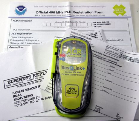
I was pleased to get an email from NOAA this weekend reminding me to renew the registration of the ACR AquaLink View PLB I first tested in 2010. I’m especially aware of how important it is to keep distress beacon info up to date because in Miami I got to visit the USCG District 7 SAR Command Center and meet the folks who tend to 44% of all CG EPIRB/PLB activations. And since ACR nicely gave all the attendees a new ResQLink+ to test, I registered that too. As the photo shows, ACR makes it easy by providing the NOAA form with the beacon specifics already filled in and even a postage paid envelope (and ditto for the warranty), but I went online…

DHS’s Small Vessel Cooperative Tracking, what’s your guess? 44

DHS’s Small Vessel Cooperative Tracking, what’s your guess?

US_SBIR_grant_solicitation_SVCT_and_NVIT.jpg

It’s amazing how the whole boating community can apparently miss information of great interest even though it’s in plain sight. Remember how we argued about possible Department of Homeland Security AIS mandates last March? Well, had anyone poked around the DHS’s interesting Small Business Innovation Research (SBIR) Program, we would have known that the government had already expressed a desire to get the small vessel tracking job done in a much more passive manner, possibly even with benefits to us!…

AIS & DSC MoB devices, the standards revealed 20

AIS & DSC MoB devices, the standards revealed

DSC_AIS_MoB_standards_courtesy_GMDSS-au.jpg

Here’s some good news, even if I had to Google out a non-governmental Australian site to find out what the RTCM here in the States is up to. But I’ve admired the clearly written expertise at gmdss.com.au before, and I’m confidant that they have their facts right about the new standards for man overboard devices using AIS or DSC VHF (or both!). Besides, the details are pretty much what we expected, with a few interesting nuances…

GOST, the serious boat security guys 3

GOST, the serious boat security guys

GOST_marine_security_tech_in_action.JPG

It doesn’t matter that the Paradox Marine I’ve enjoyed visiting at past shows has changed its name to GOST (for Global Ocean Security Technology); I bet they’ll still be showing off some interesting new tech in Miami this week. And probably more important is how knowledgeable and sophisticated GOST has become about the nuances of marine security over the years. Experience is a great teacher, and GOST’s has been accelerated because its home turf of South Florida has endured a plague of boat bandits who are pretty knowledgeable themselves. Can you spot the telltale professionalism being exhibited on the Contender above as it blasts toward Cuba, probably for a load of drugs, or with a load of cash, or both?…

DeLorme inReach hand’s-on #2, text me! 16

DeLorme inReach hand’s-on #2, text me!

DeLorme_inReach_web_portal_cPanbo.jpg

Following up on inReach hands-on #1 — which attempted to be both an overview and a close look at its associated Android app Earthmate — let’s check out the Internet side of the system. The screen above is the user’s web portal at explore.delorme.com, which DeLorme developed in partnership with GeoPro. Given that GeoPro builds its own pro-level Iridium handhelds, like its new $1,200 SHOUT Nano, it’s no surprise that the portal let’s you thoroughly view and manage inReach communications. It could even be used by, say, a fleet manager to keep an eye on multiple inReach units…

DeLorme inReach, hand’s on #1 10

DeLorme inReach, hand’s on #1

SatMessengers_inReach_CerberLink_Connect_cPanbo.jpg

Click on this photo for a close look at the new age of satellite messaging, tracking, and distress handhelds, or at least three of the early contenders. I was cautiously keen on the DeLorme inReach when it first surfaced, but then I had to bite my tongue. Though I was experiencing its reasonably fast and affordable two-way global messaging back in August, I couldn’t discuss it because of the beta testing NDA. Fair enough, as the inReach system evolved substantially during the beta process. Plus I’ve now had a chance to compare it with the less expensive Spot Connect, whose one-way custom messaging via Globalstar was discussed here in January. Not to mention the pro-oriented BriarTek Cerberus system, which also appeared here last January and uses the same Iridium 9602 data modem as the inReach. The news is pretty much all good for anyone who boats (or hikes, or whatever) beyond cell service, but it’s going to take several entries just to lay out what I’ve learned so far…

Garmin GTU 10, a remote anchor watch? 10

Garmin GTU 10, a remote anchor watch?

Garmin_GTU10_Irene_anchor_watch.jpg

I’m pretty impressed with the Garmin GTU10 I’ve been testing this summer. Inside that little IPx7 waterproof case is a sensitive GPS, a GSM cell modem, and a fairly able lithium ion battery. For $200 you get the hardware, a cute case (meant primarily for hanging on a dog collar), and a one year standard data subscription which normally costs $50. The subscription doesn’t get you much in terms of remote tracking — just the last ten points, whose spacing will vary with settings — but you do get unlimited notifications about when the GTU 10 enters and/or leaves up to 10 geofence areas that you can define at mygarmin.com, or with the free Android and iOS Garmin Tracker apps. And aren’t geofences the key to knowing that your boat or tender are where they’re supposed to be, especially when anchored?…

Hurricane Irene, the long anchor watch #1 11

Hurricane Irene, the long anchor watch #1

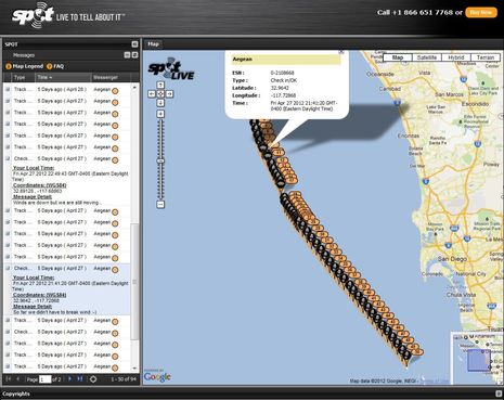
So it’s Sunday morning and the early signs of Irene are here in the form of 100% humidity and easterlies in the high teens. That wonderfully large Fortress 55 anchor seen above in my tender yesterday afternoon is set about 150 feet to weather in 20-30 feet of water and Gizmo’s regular hook, a Kingston K-45, is about the same distance to the southwest. The best part, though, is that I’m snugged into Pulpit Harbor where it’s quite unlikely that I’ll experience any significant wave action. In my experience it’s that action and the resulting line chafe that usually causes boats to go ashore in conditions like we’re expecting. You can see Gizmo’s position on this Spot share map, and I’m also using this situation to try out a number of other electronics…

Automated VHF radio checks, Sea Tow & USCG 25

Automated VHF radio checks, Sea Tow & USCG

Sea_Tow_ARC_service_map_August_2011.jpg

Sea Tow recently announced that all its franchises have now installed an automated radio check (ARC) service, and it seems very easy to use. Just check out Sea Tow’s ARC page for the active channel in your area — usually the old Marine Operator channel still managed by its communications partner Maritel — and make a call. If you’re in range you should hear an automated response telling you the location of the receiving base station followed by a recording of your call so you can confirm beyond doubt that your VHF is transmitting. Unfortunately I can’t try the system myself, as the active service map above correctly indicates that ARC doesn’t quite reach Penobscot Bay yet, but I’m hoping that readers who boat in active (yellow) areas will report about how it works…