
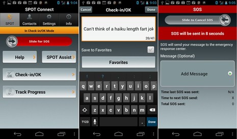
SPOT Connect, works fine & deserves attention
If it’s heartbreaking to see a cheerful-looking Aegean crew underway in fine weather less than 24 hours before they perished — as we discussed earlier this week — isn’t it even worse to know that they sent a fart joke to friends and family by satellite messenger just a few hours before everything went wrong on North Coronado Island? Getting access (via Sailing Anarchy) to Aegean’s Spot Share Page is also how I surmised that they were using a Spot Connect rather than the more familiar stand-alone orange model, which is why they could send short custom messages typed on an iPhone, iPad, or Android device. Like “So far we didn’t have to break wind ;-)” There’s more I learned…
I’ve now read dozens of articles about the accident and made it mostly through 50-and-counting SA Forum pages even though some comments made me want to shower. Can you believe that some anonymous puke would mock the just-deceased owner of Aegean for racing in the cruising class with old-looking sails? But then again some SA posters were on the race course Friday night and some are working through theories about diesel or propane fumes that might have caused the apparent inattention to navigation. And, besides, I thoroughly believe in the concept of figuring out exactly why bad things sometimes happen on boats so that hopefully we don’t repeat the mistakes.
A personal lesson in all this for me is the ignorance of the mainstream media about AIS — couldn’t they at least Google it? — along with the surprising lack of familiarity many boaters have with Spot tracking and messaging. I spend so much time researching marine electronics and hanging out in the rarefied atmosphere of Panbo that it’s easy to forget how relatively exotic these technologies still are. Perhaps worse is when I ignore a decent device because I find some irritating faults with it and/or see a better system on the horizon.
Thus I found myself searching out the Spot Connect I’ve never mentioned testing last summer, and darned if it didn’t fire up fine on the same Lithium AA batteries I used then. Plus it paired to my new Galaxy Nexus phone without any fuss, proof again that some of the Bluetooth issues I had last year were due to my old phone, not the hardware being tested. I still think Spot made a mistake by not putting a tracking control button on the Connect but if the phone connection is as easy as it seems now having to pull up the app just to start or stop tracking is not so irksome.
The Connect also acquired position and delivered a custom message in just a few minutes from my backyard, and it just took an icon touch to also make it the Tweet you can see in the 2nd column. 41 characters isn’t much but Connect — product page here — remains the least expensive satellite messaging and tracking system I know of. Plus there are options to easily contact a distress center or Vessel Assist towing with your position, and the accuracy and reliability of the GPS and Globalstar messaging have gotten better and better over the years since Spot first appeared. For instance, tonight’s test message is within 15 feet of the Connects actual position if you use the photo map overlay on my share page and I saw a regular Spot messenger deliver every 10 minute track point for days at a time when my friends Arnie and George sailed south last fall.
I think that Spot is a mature and reasonably priced technology and could be useful to lots of boaters, though hopefully not the way it’s been in the Aegean incident. However I can’t help but mention the Iridium-based two-way messenger/trackers like Cerberus, YellowBrick, and inReach. They’re more expensive and have new product issues, but I’ll have some good news on the latter soon. I may be an out-of-touch old fart, but I think that lots of boats will sport satellite tracker/messengers eventually.
PS John Neyland, formerly with Garmin, sent this photo along with these words:
Theo Mavromatis was a very interesting and intelligent guy who you just really enjoyed working and spending time with. He was a true innovator when it came time to decide what to engineer because he knew that any successful product needs BOTH quality engineering AND a practical business use case that will allow the product to be sold across as many markets as possible. I will miss the relationship with Theo as well as his “always on and thinking outside the box approach”. Rest his soul at Sea aboard his pretty 37 Hunter Aegean.


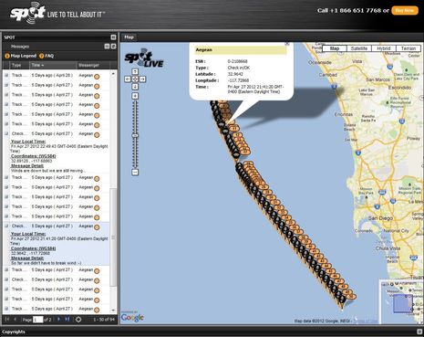
Visually it appears Aegean arrived at the island a minute or more before the last transmission. Reading the SPOT page got me wondering what was it like on board between the last transmissions and the transmission that didn’t follow at 4:46am.
Reviewing this SPOT page made me feel more connected to the tragedy than any of the news reports have. It should have the same effect on the families.
With virtually no other facts and tons of speculation, I wonder if this SPOT information helps the families of the lost crew in a significant way. At the very least, it could help in knowing that there is no speculated large ship collision that took place, or additional grief wondering day by day if some unknown crew will report they saw something, or feelings that such speculated crew potentially choose not to hear, investigate, or report the collision.
Or is this technology so exotic, that the families don’t grasp the facts and implications that seem evident to us technology geeks? I hope a fellow sailor has walked thru this SPOT page with the families.
All these SPOT improvements in the last year, cool. The web site could use some improvement, or is there a feature to obtain the distance between entries right on the spot page I may have missed? Obtain SOG, COG, and distance between any chosen two points? A window showing all spot messages, rather than needing to cursor from one dot to the next ?
Good point, Dan. Spot Messengers do not deliver SOG, COG, and altitude like the Iridium 5602 products can, but it seems like interpolation could be done on the owners Spot site and his or her share page.
It’s also noteworthy that the data will drop off the Spot share page after seven days, if it’s set to the maximum and I think the owner site is also time limited, like a month. Seems odd in this age of the cloud with free gigabytes of storage.
On the other hand, Spot also offers the Adventure Zone, where you can annotate trip data and save it indefinitely. The process is a little cumbersome, though. I wrote about it here: http://goo.gl/wjUYy
There’s an unfortunate irony in the motto on the Spot tracking page banner:
“Live to tell about it”
Spot’s scare marketing was worse when it was introduced in 2007, as mentioned when I found out about the GEOS bunker in 2008: http://goo.gl/3McDW
I should add to my review, though, that I was impressed when I called Spot customer service last night. My account had been locked due to too many wrong password attempts (which can happen when you loan stuff to sailors 😉 At any rate, I got through quickly and had my access enabled instantly once I passed the ID questions. The support person was also nice about setting up one of my sample Spots not to auto renew on my credit card, though it is annoying that you can’t fully manage your account online.
Our experience with the li-batts is not as good as yours Ben.
What’s it going to take to get them to put an external power connector on these and let the battery be a back up mode on boats (etc).
If the “hit the island” theory is substantiated by further investigation, then I think there are likely two causes. The first is simply that they did not keep a good watch. South Coronado has a 10nm light which should have easily provided a one hour warning in clear conditions. The second cause is of great relavance to this forum.
The Spot track shows a constant speed and heading. I speculate that the navigator on Aegean zoomed out their plotter, put the cursor on the finish line at Ensenada, hit Goto and left the autopilot and engine to do their jobs. The problem is that when they zoomed out with a typical vector chart, the Coronado islands disappeared.
I saw this the first time when zooming out a Northstar plotter enough to see my route on SF Bay and saw Alcatraz disappear entirely! The route was no more than 4nm, yet a huge hazard in the middle of SF Bay had disappeared! Just last week I heard about a boat that ran up on a charted reef in the South Pacific because the captain zoomed out, the reef disappeared and he set his course without further checking.
This is a serious problem with the current generation of vector charts and plotters. However, it is not a fatal flaw as the decision regarding what to display is entirely in software. The data is in the chart, the flaw is in the decisions made by some programmer about what to display. I don’t know whether that programmer works for a chart vendor or plotter manufacturer, but it is a software problem, not a data problem.
More importantly, it is a problem which can be easily addressed. It is easy enough to generate a “hazard” mark when the underlying hazard itself is too small for the scale currently being displayed; something indicating the operator should zoom in further for additional information. Yet we have all just accepted it as a flaw of vector charts. How many boats and lives must be lost before we demand that the chart vendors and plotter manufacturers address this problem?
Certainly all captains have responsibility for their vessels and I do not believe the chart / plotters vendors are responsible for these losses. However, we have a right as customers to demand accurate charts which display all relevant hazards at all times.
Perhaps the crew failed. Perhaps technology failed. But my squadron once sortied two aircraft to follow a Learjet across the Pacific.
It was on autopilot.
The crew and passengers were visibly dead.
Absent a medical examiner’s report, we will never know if there was a living watch-stander or crew on this boat or not.
So while it is a good idea to examine the possibilities, it is a bad idea to pontificate.
Garmin’s Auto Guidance technology will plot a course for you which avoids hazards.
There was another no-pilot aviation incident recently in the Gulf of Mexico:
http://seattletimes.nwsource.com/html/nationworld/2018020374_apusgulfplane.html
Russ, I find your speculations have a plausible basis. This was essentially a coastal trip, and a paper chart (or a deeper appreciation of the range function on an electronic chart, or both) may indeed have alerted the crew that their “best course” went straight through an island. I cannot think of another situation for which the AP would be set to go on that course. The prudent navigator always offsets waypoints heeding shore, depth and a decent distance from a nav aid.
So while we may never know whether the crew was alive, dead, unconscious or just asleep, someone set a course that went straight into a cliff. That would seem counterintuitive, if you didn’t notice stuff vanishes from chartplotters predictably.
Russ, Vector chart presentations at different zoom levels — and on different plotters with different presentation setups! — is a very interesting subject. And this particular case brings up another variable, which is what happens when your chart card is on the edge of its coverage area, particularly at an international border.
But I very much doubt that this issue has anything to do with the Aegean disaster. Let’s remember that the owner/operator of this boat and most of his crew had done this race several times before, and there are many indications that they were quite competent at it, including winning their class.
Here’s another data point: I got a call from a guy who’s worked at high levels in the marine electronics industry who told me that he’d spent time on a project with owner Theo Mavronmatis and that he thinks it highly doubtful that Mavronmatis would have made an elementary navigation error. He couldn’t detail the project due to an NDA, but apparently Mavronmatis may have made a significant contribution to marine electronics, though now it will be sadly posthumous.
At any rate, I’ve been zooming in and out on various digital charts that include North Coronado Island this morning, and while the results weren’t bad, there are some issues that illustrate your concerns. I plan an entry about it next week, and it would be great if readers who have chart cards or PC vector charts for this area tried the same experiment and sent along screen shots (to ben_at_panbo.com).
This is a huge issue in the San Juans and Gulf Islands where we have about 100 more islands at low tide than high tide. Route plotting is really a weakness of chartplotters over paper charts, none of the many systems that I have used make it easy to plot a long distance route while at the same time seeing the hazards that would show up on a more detailed chart. There are a lot of areas that look nicely blue that have rocks in the middle. I have plotted routes over rocks before. It can be quite a surprise; if the “whale” dives twice in the same area you had better check the chart again.
Auto routing, despite its problems, is probably the way for the industry to go — or at least some method of checking the route by default. Sure, old salts will be horrified but let’s face it — few boats have decent chart plotting tables anymore.
I’m not sure that this is the issue with the Aegan tragedy (my heart goes out to the families of all involved.) The route is too direct. I suspect that they plotted a course to the light, set the autopilot into “no drift” mode and then something happened. It is even possible that they were not using their chartplotter since back in the stone ages you would navigate by plotting a course to the light and following that compass heading until sighting the light. The collision was at 1 AM in the morning so it is most likely that somebody fell asleep, although given that there were no course changes at all once the engine was fired up c02 poisioning seems possible.
We call them ledges in Maine, George, and we have thousands of them. If you see a gull or cormorant who looks like he’s standing on the water — or a seal who seems to casually reclined there — watch out!
I promise to create an entry about chart zooming problems next week, and auto routing is an interesting possible solution, but let’s keep this entry to SPOT and the Aegean please.
Ben – I don’t have the chart libarary to do a good job of the analysis. If I did, I think a good starting point would be to have the range set such that Aegean’s position at 2000 PDT (the time the race instructions permitted engine usage) and the finish line at Ensenada are both visible on the chart.
Then it would be interesting to see the effect of various display options. For example something like turning off Display Sectors on beacons/lights, or anything that would have de-emphasized the light on South Coronado.
A further thought. If I was doing this race I would probably have set a waypoint for the finish line and then have used the VMG to waypoint and other calculated data to help guide my gybe angles, etc. It’s possible that at 10pm they just turned on the motor and AP with the plotter already set for the finish line and never even looked at the chart.
Of course it’s speculation, but the Spot track strongly suggests that this was in some way an electronically assisted tragedy.
OK, Russ, I’ll try that experiment and anyone can contribute to a group test. Here’s info from Aegean’s position at about 2000 PDT:
Check in/OK
7 Days ago ( April 27 )
Aegean
Your Local Time:
Fri Apr 27 2012 22:49:43 GMT-0400 (Eastern Daylight Time)
Coordinates: (WGS84)
32.89128 , -117.68863
Message Detail:
Winds are down but we are still moving…
I don’t think they started motoring for another hour or two but no matter. I can you right now that when zoomed out at a scale that shows that location and Ensenada, both a Simrad NSE12 with its built-in Insight charts and a Raymarine e7 with included Navionics U.S. Silver chart card show North Coronado Island, though of course it’s not many pixels worth.
PS For those not familiar with how to convert the decimal degrees lat/long format Spot uses to degrees and decimal minutes, just multiple the decimal part by 60. Hence Aegean was at 32°53.4768’N x 117°41.3178’W. If your plotter is set up to use seconds, just multiple the minute decimal value by 60 again.
I’m so glad you mention the request for an external power connection.
For offshore, long distance sailors SPOT is not practical using AA batteries. SPOT Connect needs a way to plug in a 12 VDC power supply so it can run 24/7, if need be. Except for this one point, I would run out and buy one today. I can afford the SPOT but not the constant supply of batteries it would take to make this useful for me. Besides, the landfill does not need more discarded batteries.
Sad and interesting. I do a bit of overnight offshore sailing a few times a year (I generally limit it to no more than 3 nights offshore at a stretch if possible. I’ve raced my boat to Hawaii from SF, doubled handed from Hawaii to Seattle, sailed Alaska including the offshore route, been down the east coast of the US offshore, little overnight gulf stream sail to the Bahamas, etc.
In short, I am surprised this type of thing doesn’t happen more often. Staying awake and alert offshore in the wee hours isn’t easy, especially if conditions are calm enough that you are not on edge. My “solution” is a $30 Timex watch set with an 8 or 10 minute countdown timer… if I don’t manually reset the timer within that period – which is when i stand up and take a good look around, check the plotter, etc. – it starts beeping at me. This is a little extra insurance that i don’t doze off or get lazy and forget to check lights and plotter/radar at set intervals. On several occassions I HAVE dozed off and the beeping watch woke me up. How long might I have slept without the beeping watch??!
Maybe someone will find this info helpful.
Is it true that they would have needed to use their cell phone to send an emergency signal with the Spot Connnect? I didn’t see a way to send one otherwise from the rather skimpy website on it. I would consider this a serious liability since iphones tend not to be waterproof.
It does show that while a great tool (I have the normal orange one), the Spot is not a replacement for a genuinue EPIRB for on the water use. No emergency signal was sent. If they had an auto-activated EPIRB there would have been a response much earlier (response only started when the debries field was noticed.) It is possible that lives could have been saved.
It makes me think, because I have a spot and a McMurdo personal EPIRB but no automatic system.
No, that’s NOT true, George. The Spot Connect itself has a distress button just below the power button behind a little door so you don’t activate it accidentally.
But if you can use the phone app in an emergency situation you can send a custom message along with the alert, as illustrated in my screen shots. I just wish there was a button on the hardware to activate tracking as that would be quicker and easier than using the app.
I doubt that an automatic EPIRB would have helped Aegean, but it sure has helped in other bad situations.
That is great, I might upgrade my current Spot to this model. They should highlight the fact that it has a standalone emergency button, it doesn’t seem to be mentioned in their advertisement and is not even that easy to discover from their user’s guide.
I am curious why you do not think that an EPIRB would have helped the Agean. Because of the race, there were plenty of boats in the area that would have been able to respond to a timely distress signal — in addition to the coast guard with spotlights and night vision. Not to speculate too much on this tragedy, but for all we know, the crew was hanging onto the deck while the boat was battered to pieces under them.
They hit the rocks at around 1:30 am. The SAR response started at 10:00 am. It certainly seems to me that the difference between a 10-minute response time and a nine-and-a-half response time could have saved lives. It just sickens me to think that they could have been hanging onto the boat for hours with nobody aware of their predicament.
Check out http://www.spotwalla.com –
Website that adds better tracking for the spot.
A couple comments… yes, the SPOT website is very annoying to users as you must endure their sales hype. HELLO, I’ve all ready bought one! Now, let’s get user focussed and cancel all the b.s. And, NO, 90% of my share page viewers are NOT your customer base or your market segment. The Lithium Batteries are the best choice for this product, period, and for most devices with auto-shut-off & not a current hog. 15 year “shelf life”, ’nuff said. Up here in Nor Cal more than one tired offshore captain has pulled up the waypoint list and selected Santa Cruz’s Sierra Charlie One Buoy not realizing he/she had worked their way north of Pidgeon Point and engaged the auotpilot. There are an amazing number of Santa Cruz boats that have ended up on the beach.
Note that Globalstar quietly announced it was dicontinuing the SpotHug marine product effective January first, 2012. A victory for the GSM/GPS products. Satellite links too unsure and erratic-even at a mooring, we are told by ex-customers.
I don’t think that’s a fair characterization, Alden. I read through the annual report where Spot reported discontinuing the HUG and one thing that’s obvious is that it’s a fairly big company with lots of balls in the air, and few of them in the marine world. I would not like to manage a sat coms company, but that doesn’t mean Hug was discontinued because of performance issues. Off boat monitoring and tracking has always been a tough market.
Besides, what Spot says about the Hug is: “We stopped producing more — but that doesn’t mean we can’t or won’t once our current inventory is depleted.” And I haven’t heard complaints of “unsure and erratic” connections. In fact, the Spot Messenger — which uses the same simplex data system — seems to have gotten more and more reliable.
Per the Practical Sailor blog it is said the Aegean sent out a SPOT distress call, which was not promptly followed up on due to a couple of factors.
http://www.practical-sailor.com/blog/-10824-1.html
I think I’ll keep my EPIRB!
Thanks, Graham (and others via e-mail). Something seems odd about this report and I look forward to learning more.
Re the AEGEAn accident:
I will be VERY interested to see exactly what message was generated from the device. The SPOT can send several types:
1) OK – check in
2) Assistance – Non emergency to listed friends and family
3) Mayday – 911 or other first responders like USGC
#2 is for non emergency situations, like you lost the keys to your truck after a hike. SPOT has a very good record of sending #3 messages to responders EVEN IF there is not an exact GPS fix corresponding. My guess is that the crew generated a #2 by mistake or in haste. Sadly it was not their first of the evening.
Charlie Doane has a good summary of what’s been learned so far about the Aegean tragedy:
http://www.wavetrain.net/news-a-views/393-aegean-tragedy-us-sailing-final-report-preview
Also, while the accident report isn’t out yet, one of the team confirms that there was a brief Spot distress signal:
http://www.cruisersforum.com/forums/f106/sad-news-again-off-mexico-80977-10.html