
Cruising with Garmin wireless: BCM, 741, HomePort & quatix
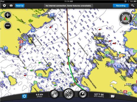 Some of Garmin’s many wireless strategies are coming together on Gizmo and there have been some nice surprises. Since there’s now a GPSMap 741 with built-in WiFi mounted at the lower helm and networked via NMEA 2000 with the 7212 on the fly bridge, one of the first things I did when we began our cruise last week was to see what that meant in terms of route planning on an iPad running BlueChart Mobile (BCM). It was a minor thrill to realize that I could spec out the day’s plan on the pad, send it to the 741, and have it pop right up on the 7212 as the active route my sweet mate was using to steer by…
 The feature is activated with that “Navigate To” button on the BCM route menu. You do have to accept the route transfer and activation on the 741 but then it’s pushed over N2K to other Garmin MFDs on the network. Nice! (And note that while BCM is not itself a navigation program you can use it to keep an eye on your sweet mate’s steering, as shown on the top screen.) The iPad, indicidentally, is using Gizmo’s GPS over the same WiFi link. I’m pretty sure that Garmin could also be sending depth, wind, AIS, and other N2K data to BCM if they felt that customers would value it, and of course they could also develope another app that mirrors and controls the screen of the 741 and other WiFi-equipped MFDs (as Navico, Furuno, and Raymarine have). In the meantime, though, note the “Send to Device” button on that same route menu above…
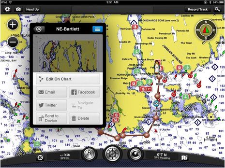
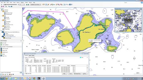
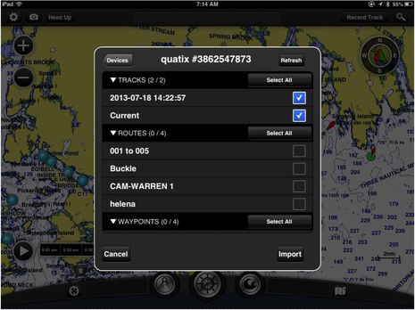 If you have a Garmin quatix watch ‘device’ you can send it BCM routes, tracks, waypoints or ‘catches’ — a specialized waypoint with fields for all sorts of fishing info. You simply put the quatix in BCM Share mode and it just works, no messing with Bluetooth pairing needed. As seen above, you can also import data from the watch in a very flexible manner. Import/export of data from BCM to Garmin WiFi MFD is all-or-none (as illustrated here) and could benefit from a similar pick list .
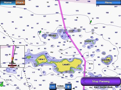
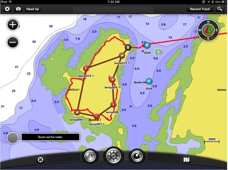 At any rate, the screen above suggests how I created an island hike route in BCM, sent it to the watch, and then downloaded the watch’s track of the trail we actually found. The same evolution might work nicely for a racing sailor, first mapping the course as a route in BCM and then able to follow the boat’s progress even from the rail. And if your boat has a GNT 10 NMEA Transciever installed, you can also get Wind, Depth, etc on the watch, at least theoretically. (My test unit is still sending bogus info, like a depth of 23,006 or -5 feet, for some reason yet undetermined)…
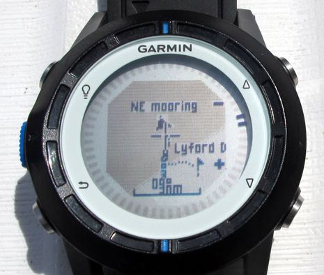 Oops, I notice this morning that some quatix watches are subject to a voluntary recall due to a possible battery heat problem (only one reported case), though I have little doubt that the watch will be a very successful product, especially once the bugs are squashed. I plan a full review eventually, but I find the watch phenomenally powerful and fairly easy to use given the small screen and only five buttons. For instance, I could have used it to steer to Isleford Dock (even though I badly misspelled the waypoint name when created in BCM, and should know better) plus I can drill down on that map screen above to such detail as our two failed anchoring attempts on a heavily grassed bottom nearby. And I could have asked the quatix to turn that detailed track into a route back to Buckle Island.
 While the quatix watch won’t share routes, tracks, etc. with the Garmin 741 (though maybe that’s possible eventually?), it does play very nicely with Garmin HomePort PC (and Mac) software, which has gained a lot of features since reviewed here in 2010. It can, for instance, handle quatix software updates and it now includes integration with ActiveCaptain cruising info. The screen above shows another hike on an island (too steep to circumnavigate with forest too thick to bushwack). It’s easy to drag tracks, routes, etc. from the watch to an archive or to an SD card that you can later use to merge or replace MFD data.
Note, though, that there is currently no way to share BCM data with HomePort except via an MFD and SD card. While that “Email” command seen in the BCM route menu is nice for showing folks where you’re headed it does NOT {correction 7/28} include, say, a GPX or KML file that can be imported into HomePort (which can also export Garmin data to GPX format).
 I’m also a fan of Garmin auto routing, even though it can occasionally make a very poor choice, as seen above. But you need a BlueChart g2 Vision chart card to get auto routing and the one I’m using is pretty old. Or maybe it’s the MFD, in this case a 7212? I notice that the 741 seems to have more custom auto routing parameters and I will experiment with it and also with the new GPSMap 8212 headed to Gizmo for testing.
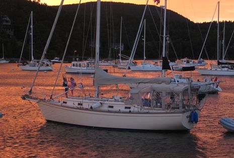
 So — holy cow! — Gizmo will be getting yet another WiFi access point (when I turn everything on). There’s much more testing to be done this summer, though I’m trying to mix it judiciously with boat maintenance and cruising fun. Below was the neighborhood scene in North East Harbor (our last visit covered here in MBHH) on Saturday night just after a big front crashed through with wonderful dry, cool air in tow. Those two young sailors had gleefully learned to use the jib boom like a jungle gym and here’s hoping they’re boaters for life.


Ben,
Please do this experiment: walk off your boat with the Quatix with the MOB functionality enabled. After 60 feet, it will trigger a MOB on the Garmin MFDs and your autopilot will want to navigate to the MOB.
Now, does that MOB point show up on other manufacturer’s MFD?
I don’t think it will work, but shouldn’t all NMEA 2000 devices be able to share this kind of critical information?
Xavier, I also got about 60′ from several boats before the Quatix disconnected and triggered the MOB alarm. It is my understanding that this is a Garmin proprietary
message, and hence won’t talk to other manufacturers gear.
Bill,
Yes, that’s what I understand, but I wanted to see if Ben could confirm it definitively.
I think it may be a missed opportunity for Garmin. If the Garmin passed along MOB alert and position to other N2K devices, buying a GPSMAP 441 and a GNT 10 would be quite affordable, I figure, in addition to getting 4 quatices to be used as MOB devices on our boat.
What other alternatives are there for a surefire MOB system? Best I can come up with is Kannad R10s automatically armed on Spinlock or Ocean Safety vests.
As I sit here at 5AM in the most southern port of the USA and try to accustom my eyes to moon vision for an escape tomorrow morning from the effects of 30 thousand lobster snatchers, and planning my route east and north before they drop a quarter million styrofoam prop entanglers in my way, I wonder: “Where,s the App for that?”
Capt John, it is called spurs. They are an essential piece of hardware. Have not hit anything in 10yrs but have piece of mind while navigating the lobsterman’s minefields.
Is there a N2K or 0183 standard PGN for MOB?
Raymarine and Garmin both state they send their MOB only to their respective equipment.
Hi Ben, We are out to mooring 451 just forward of Isobel. When you resurface lets go to North Haven on Audrey Louisa and check out the 8000 stuff. B
Sounds enjoyable and educational, Brian!
Pat, I don’t think there’s been a specific MOB in NMEA 2000 but recently a whole set of Alarm PGNs was added that are suppossed to be very powerful and flexible. Now we need more manufacturers (besides Maretron) to support the new PGNs.
Xavier, I tried the quatix MOB yesterday without success on even the Garmin MFDs. I may have a bum GNT 10, which might also account for the distortion of some N2K streaming data, or I may have been doing it wrong. Will try some more.
Capt. John, I’m sorry to report that there are more lobster trap buoys than ever up here (though fresh lobster at reasonable prices is abundant). I equipped Gizmo with a one-piece Evolution Marine Shaft Razor that is virtually unbreakable and very effective:
http://www.evolutionmarine.com/detail.html?id=3002&cart=tskkhqai
I also carry a wet suit, mask, and goggles as well as Kevlar gloves (so I don’t cut myself on the Razor) and a slick Hooknife from Sailor’s Solutions:
http://www.sailorssolutions.com/?page=ProductDetails&Item=CH01
There are several ways this boat (like many) can catch a pot buoy and hence multiple solutions, but it doesn’t happen often. There is no app, but having excellent charting, routes, and radar means we have more time to focus on slalom driving 😉
FYI ….. Garmin released a new update for Homeport yesterday, July 25th. Fixed some issues. One of the more interesting features of Homeport is the Sonar playback with the ability to add waypoints via Homeport. You can display both a chart location and sonar data simultaneously
This sonar sequence was recorded from my Garmin 547 CHIRP unit.
Sonar 1
Sonar 2 Expanded HP Display
Tom
Hi Ben,
Your comment re: GPX export from BCM, I assume you meant “it does NOT include … a GPX or KML file…”. Alas, I can not find anywhere in the latest BCM release where GPX export is possible.
I mostly need something like BCM for route planning, but BCM itself is not working for me. I’ve got several issues reported into Garmin many months ago, so far no joy.
I tried to use BCM for entry of racing instructions. Several routes which are variations of a limited set of waypoints (often government marks). Highly frustrating and time consuming using BCM.
What I need is the ability to easily drop waypoints at the coordinates of navaids (using the chart), then be able to construct routes using a pick list of these existing waypoints (not using the chart).
– it is very difficult to locate desired navaids … many of which were only displayed at close-in zoom level. I recall this is a limitation in the cartography, as display of the navaid mainly depends on it being present in the cartography’s specific zoom levels. FYI this capability is far more easily accomplished on raster chart.
– provide an easy way to create a waypoint from a highlighted navaid, using the navaid’s coordinates.
– provide a way to build a route from a pick list of existing waypoints OR tap an existing waypoint from the the chart.
– route legs displayed on the chart should overlay non route waypoints. As it stands, all waypoints are displayed on top of route legs. Any non route waypoints, through which a route leg passes, appear to be a member of the route. Very confusing.
– Simple export of all route and waypoint data via GPX file to email address, etc.
So I’m using iSailGPS now for all my waypoint and route planning. Working well.
Thanks, Paul! You’re right and I corrected the text to say that emailing routes from BCM does not include route files, just a snapshot and description.
However, I wonder if you’ve updated your copy of BCM. I noticed recently that it can very nicely use existing marks as waypoints. When you’re creating or editing a route you can get a waypoint to ‘snap’ to a mark, which is obvious because it creates a different type of screen waypoint icon. Also when you edit marks and drill down tight, BCM puts up live lat and long coordinates which should help make them more accurate (if you don’t just modify the coordinates in the edit box).
The neat thing that BCM does not do (yet) — I say that because many Garmin MFDs do — is to let you snap a waypoint to a nav aid with the point then getting the exact coordinates of the aid as well as its name. Also hope that a future version of BCM will export routes in GPX and KML formats.
Finally, I’m surprised by your comment about nav aids not showing on large area zoom outs. I think Garmin charts are quite good about this, and don’t know any electronic charts including rasters that are much better. What I have noticed sometimes is that water depths, particularly the critical least depth on an underwater bump, do not show well until deeply zoomed in.
@Ben
Yes I have the latest, and the snap-to waypoint is a step in the right direction. Snap-to navaid is needed, or snap to navaid when creating a waypoint. Make the navaid-to-waypoint as automatic as possible.
Re: the navaids and zoom levels, check Chatham to Pollock Rip to Nantucket. Nearly zero of the navaids display until zoomed pretty close in.
BTW a cross hair in the menu dial would also be very helpful.
Hey Garmin, GPX export please.