
EarthNC: routing, NEXRAD, & Baron XMWX
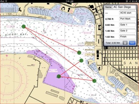
I use the iPad version of EarthNC fairly often because I still like how it can overlay and detail NOAA weather buoy and forecast info, a feature it had when I first tried it. I also like how the quilted NOAA raster charts look on a pad (but then again I’m an old guy). Now EarthNC has added a pretty full featured route-making routine to its iOS version, as I tried to illustrate above by laying out the San Diego America’s Cup course I’ll be seeing up close later this week (I’m so excited). Note how I was able to easily type in waypoint names, and what you can’t see is how easy it is to move one, or delete it, or add a new one along a track line…
Another nice feature for when you’re making real routes of some distance is that EarthNC can download and cache charts based on the route instead of a rectangle you specify. The main gripe I have so far is that once you save a route you can’t get back to that edit screen (unless I’ve missed something). But you can get the program to guide you along a route, or just show the waypoints (with or without labels), and you can also export it as a .gpx file. I haven’t tried that extensively, but was pleasantly surprised to find that clicking on the AC gpx on my PC got Memory-Map to download the San Diego NOAA chart and show the “route” with all names intact. Coastal Explorer 2011 also imported the route without damage.
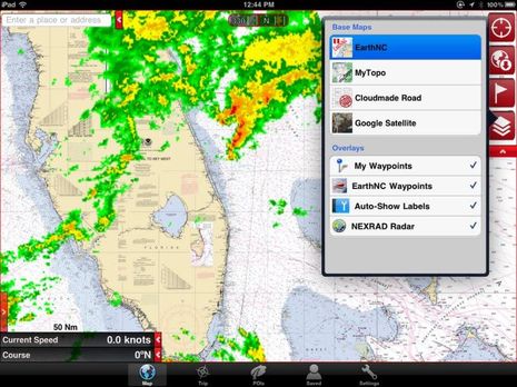
Plus EarthNC added NEXRAD overlay recently. It’s not animated yet, but it’s still useful and, yes, it certainly did rain some on the Fort Lauderdale Boat Show. I gathered there that one of EarthNC’s next projects is to enable easy route synchronization between its phone and pad apps (there’s even a free Android version) and its free online chart viewer. In fact, all the charting apps are getting better and better. Actually MemoryMap’s iOS app already has a very nicely designed routing facility and they are editable after the fact. And I’m getting the idea that Coastal Explorer is going to get some sort of iPad relative eventually, which should be interesting.
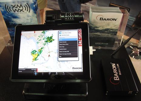
But I’ll close by noting that EarthNC is the first third party app to take advantage of the new Baron Mobile Link I first saw at NMEA. So the NEXRAD overlay you see on the iPad below is quite different than the one above. It’s coming down from the XM satellites instead of over the Internet and so you’d still have it — and lots of other Baron data — over in the Bahamas or out in the deeps. It’s yet another example of the many ways mobile devices are integrating with marine electronics, and a particularly good one of how it can look simple on the surface — like live weather wherever you go on the same app — while it’s pretty darn complex under the hood.


Note that the Android versions of EarthNC still don’t have the weather buoy or forecast info, not to mention the latest NEXRAD overlay and routing. Actually, I’m not positive of that because I lost the HD version recently as it was beta copy and I had to — ahem — do a factory reset on my HTC Incredible because so many things like Bluetooth and email syncing weren’t working right. But I did install the free version of EarthNC and, though it lacks the features mentioned above, it’s got a lot going for it. Plus Android users can get great marine weather via the BlueFin app.
I don’t have an iPad yet, and am still pretty naive about chartplotter-simulation apps available. Does EarthNC only support NOAA raster charts?
The reason I ask, is because I hate “North up” which is probably the only practical way to view raster charts. Maybe I’m lame, but “course up” is part of my DNA.
Also as an aside, I believe that the Navionics app (which I think uses their vector charts)does not permit “course up” either, but maybe that has changed recently?
Can someone educate me?
I tried to take a look at EarthNC in the iTunes Store and found it was for mature audiences only, (that leaves me out).
“Rated 9+ for the following:
Infrequent/Mild Mature/Suggestive Themes”
I guess once you peal off the weather overlay it gets pretty revealing. Maybe too much for some of us especially if you have young impressionable navigators in the family 🙂
Anyone know why this app is rated 9+? The expanded warning is even more dire.
Richard, I’ve seen that strangeness with some of the other charting apps, and think it has to do with their ability to download imagery…and maybe Apple’s poorly crafted content rules?
At any rate, I believe we’re all mature enough for NOAA raster charts, even if we feel like boys.
Karl, I don’t think many charting apps can do Course Up yet (which I also like, even with raster charts). Maybe none. But iNavX will do Heading Up, and Charts & Tides permits rotation, and there may be others that offer choices beyond North Up.
Ben,
Thanks for the great review.
The EarthNC iPhone/iPad Apps support course up mapping – rotating the NOAA RNC charts to your heading. While this will leave labels ‘upside down’ depending on the chart and your heading, it’s still a very useful display mode. Just tap on the ‘track’ button twice instead of once.
We’re working on adding the ‘edit’ route capability to saved routes as well as the app/web sync of routes and waypoints. You can also import GPX routes/waypoints into the iOS apps from other sources via email.
As far as ratings go, Apple requires minimum ‘age’ ratings for apps that connect to the internet – just in case a precocious junior boater happens across a ‘salty’ comment in any of our marina, anchorage, or hazard lists I guess.
– Virgil
EarthNC
Thank you, Virgil, and sorry I missed that. But I do think that there’s a significant difference between Heading Up and Course Up. The latter, which can only work when there’s an active waypoint, tends to be a steadier display, especially so on an iPhone or iPad that isn’t in a fixed mount. Course Up is what I’d like to see.
iPhone 4/4S and iPad 3G have both a GPS receiver and a magnetic compass. I can’t speak for EarthNC, but in the case of iNavX it can use either GPS COG (Course Over Ground) OR magnetic compass HDG (Heading) to orient the marine chart. In iNavX both are slightly dampened to provide for a smoother experience. The downside to using COG, is the vessel does need to be underway before COG is available.
I think COG is preferable for a mobile device on a boat unless the device is fixed and oriented to the boat’s lubber line, like a compass. But better yet is Bearing to Waypoint (BTW) which is what Course Up is on most plotters. It’s a very steady value, at least until you get right next to the waypoint.
Ben, Excellent suggestion. Next iNavX version will use course to the active waypoint as the chart orientation. In the event now waypoint is active then COG or HDG will be used as previous iNavX versions. It’s this type of feedback that helps make apps much better.
Ben,
Thanks for the ongoing discussion. We’ll certainly consider an option to use Bearing to Waypoint as an orientation option in future releases.
For clarification, EarthNC currently uses GPS course over ground for orientation anytime the speed is over 3 knots or so and the mag compass (which is quite noisy) under 3 knots.
– Virgil
If you’re an XM Satellite Weather user, please help the college student with her poll on the Forum: http://goo.gl/GOJHNI
Meanwhile, in Miami I saw a lot of improvements in the Baron QuickLink marine weather services — global and US — and hope to write about them soon:
https://www.baronservices.com/marine