Furuno SCX20 & SCX21 satellite compasses, the impressive demo at NMEA
While Furuno has just introduced powerful new TZT3 multi-function displays and NXT solid-state radars, that’s all the more reason to highlight their remarkable new SCX satellite compass design. After seeing prototypes demonstrated on the water, I believe that the technology delivers much more than similar sensors at a reasonable cost with lots of install flexibility. In fact, I expect to eventually see the SCX20 mounted on boats that don’t even have other Furuno gear and hope to see other brands develop similarly advanced multi-sensors.
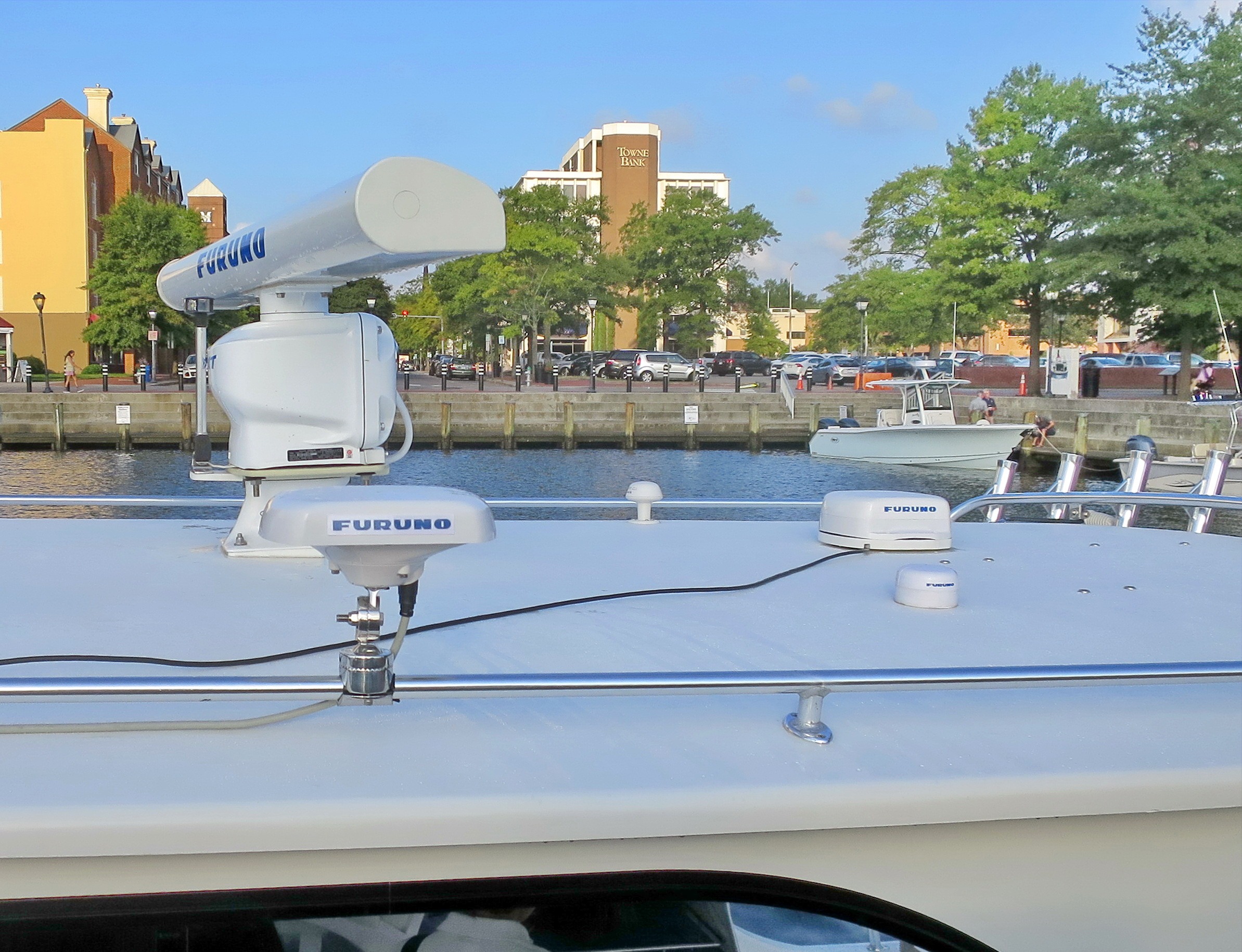
Last September Furuno had progressed enough with the just-now-announced SCX compasses to show off beta units at the NMEA Conference. There was an engineer on board and some of the numbers you’ll see in my demo photos below were suspect, but she was downloading a new firmware version as Ben Stein and I left the boat and I’m confident that the SCX data output is even more impressive now.
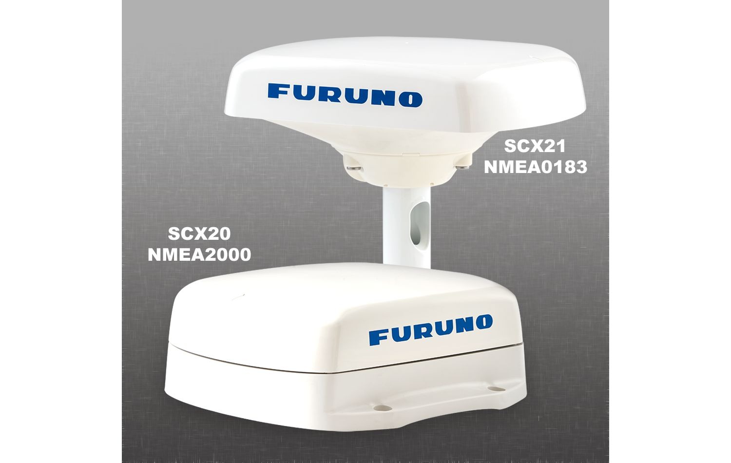
You can see above that the SCX21 for NMEA 0183 and the SCX20 for NMEA 2000 are both compact enough to fit on fairly small boats. What’s more, aspects of the new design detailed below purportedly make the SCX much better at handling the multipath interference that can mess with many satellite compasses if they don’t have a very clear sky view.
Note too that the SCX20 can be used with the pole mount base, though the 21 does not work with the roof mount base (probably because of the larger connector).
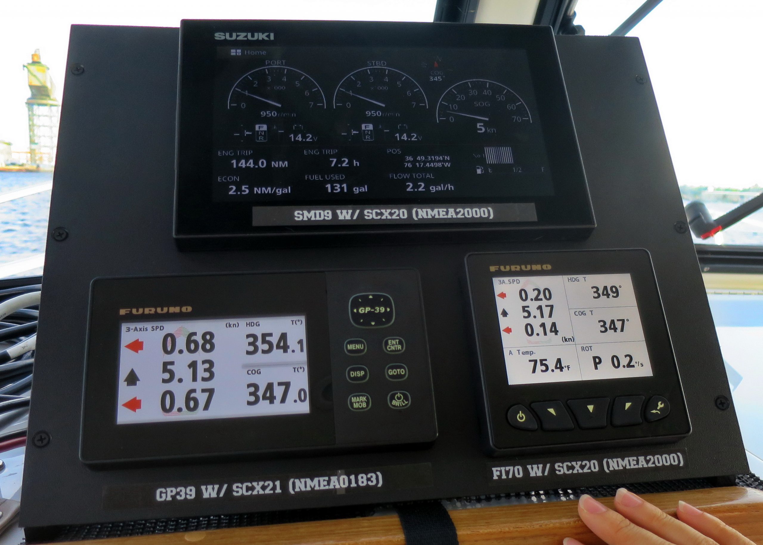
Both the SCX sensors retail for $1,195, a far cry from the venerable Furuno SC33 at $2,595. And while the 33 claims 0.4 degree Heading accuracy, I believe that the SCX design’s highly responsive 1 degree accuracy is plenty good enough, plus it delivers valuable data the 33 can’t.
Actually, I’d never seen the 3-Axis Speed displayed above on any boat, but I’d sure like to have it on mine. The SCX is measuring the boat’s forward Y-axis Speed over Ground like a normal GPS (except for the claimed 0.02 knot accuracy). But because the sensor also knows how the boat is rolling, pitching, and heaving — and because specifying the boat’s size and its location are part of the installation process — it can also determine the left-right X-axis speeds at the bow and stern.
You can even set up the SCX to deliver 3-axis speed at the height you’d prefer, like at your boat’s waterline. Wouldn’t that be handy when, say, thrusting up to a floating dock you can’t see very well from the helm?
In the scenario I photographed above, the SCX21 shows the demo boat slipping leftward at 3/4 of a knot, which made easy-to-understand sense given the tidal current in the Elizabeth River and also given the 13-degree COG/Heading difference. I can not explain the similar but different values coming from the SCX20 except to note again the demo’s “prototype” aspect.
The SCX design employs four GNSS receivers each able to work with the GPS, Galileo, GLONASS, and QZSS satellite constellations, SBAS augmentation included. And while many satellite compasses use a single two-receiver baseline to calculate Heading, the SCX uses all six baselines possible with this array.
Hence the resistance to multipath interference, though also note how the low altitude signals possible with bounces off other onboard gear are shielded out. Moreover, the SCX can be set up to further filter out low altitude satellites, which might also help if someone is trying to spoof the positioning systems.
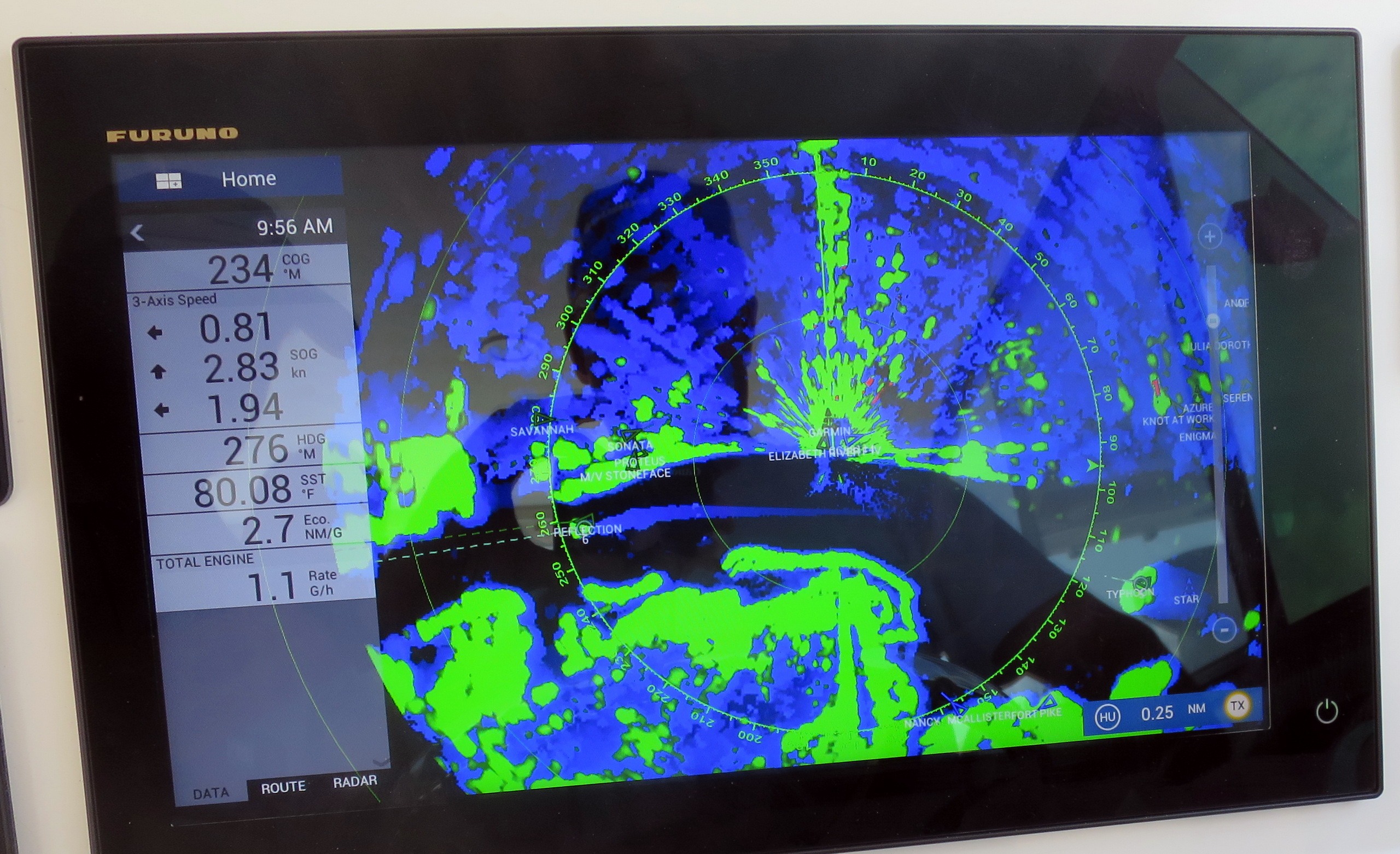
Furuno is particularly proud about how well the SCX can support the True Echo Trail feature available with many of their radars, and it is truly sensor challenging to completely remove your boat’s motion from what a radar sees so that the true past motion of a target is shown by its trail. And since the two are sourced independently, data errors show.
In this case, the demo boat is just nosing back into the Portsmouth docks and the steady blue trail behind the vessel out to the left in the river indicates that our sharp right turn and other maneuvers were accurately removed. Furuno calls it “Echo Trail ZIG-ZAG Domination” with comparative screenshots using (unfortunately unnamed) competitor satellite compasses.
The SCX sensors also calculate Heave, which can be used by some MFDs to stabilize sonar imagery, as I saw dramatically demonstrated with a $3,000 SC30 in 2008. The difference now is not just the greatly reduced cost; Heave is now a standard NMEA 2000 PGN which is output by the SCX.
In fact, all the SCX20 data output seems to be in standard N2K format so it should be usable by any N2K display, autopilot, sonar processor, camera stabilization system, or whatever else can read the PGNs. Which is why I think that these compasses will get installed on non-Furuno boats. Yes, there’s still the issue of firmware updating and configuration — common to independent NMEA 2000 sensors — but there’s good Furuno news in that department too.
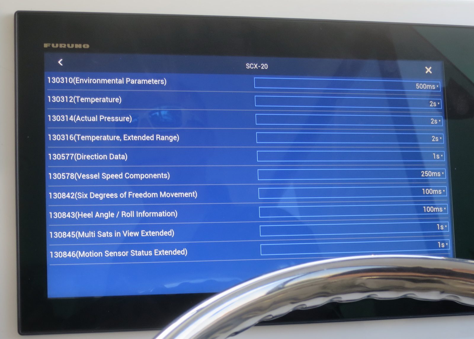
First of all, the configuration possible with both SCX devices is extensive, and setting up or tweaking the SCX20 using a TZT2 (or the new TZTouch 3 MFDs) looks easy. You can read all about it in the SCX20 Operators Manual downloadable here, but note too the SC Tool Operator’s Manual.
The SC Tool is a Windows PC program that can be used with either SCX sensor or the SC33. And don’t fret when you see that using the tool with the SCX20 requires an uncommon CANbus to USB converter and a patch cable. Your pro marine electronics installer may have these, but Furuno tells me that the Tool will soon work with an Actisense NGT-1-USB NMEA 2000 interface. Many installers and DIY boaters already own the NGT-1, and it’s also the standard N2K gateway for the Furuno-related TZ Navigator and Professional PC nav programs.
So now we’re talking about a powerful multifunction satellite compass that can be independently updated and managed — even diagnosed if there’s trouble — regardless of what other electronics it’s helping to perform better. And the SCX doesn’t cost an arm and leg.
I’ve tested two satellite compasses on Gizmo over the years along with several high-tech fluxgate-based heading sensors like the Raymarine Ev-1 and the Lars Thrane LT-1000. They all noticeably improved everyday uses like autopilot, radar overlay, and MARPA targeting when compared to more conventional sensors. They can also help an exotic feature like Auto Slew on a FLIR thermal camera to work well, and all these sensors fed multiple MFD brands over N2K with just a few hiccups. I particularly recommend what is now the Si-Tex Vector Compact GPS Compass as a great value at about $725 online.
But, wow, isn’t the Furuno SCX20 a very nice step up?
PS 2/19: I forgot to mention that both SCX models also contain high accuracy atmospheric pressure and air temp sensors. And I just learned that there’s even a magnetic heading sensor built into the design. It’s used now to speed up the initial satellite heading calculations at startup, but Furuno plans to “deliver a software upgrade that will provide full magnetic automatic backup in the case of 100% GNSS blockage!” The company was hesitant to advertise this feature before it met their “stringent QC tests” but they’re “confident” about that now. So we’re the first to hear that the SCX engineering is even more remarkable than I thought.




Sweeeeet. This looks really good.
I learned the hard way that not all satellite compasses are equally good in multipath performance, and these new Furuno ones look like they are going to be best-in-class.
This joins the Merrimac wishlist, although the Cortex VHF still tops that list!
I don’t know where you are, Kees, but nice to see that many online outlets here are taking SCX20 orders at $995 and Hodges Marine — which has done well by me — expects to ship them in March:
https://www.hodgesmarine.com/furscx20-furuno-scx20-satellite-compass.html
Yes, the SCX2x heading sensors do look good. I was just about to place an order for the Hemisphere V200n (which appears to be a fine product, too), but the SCX20 offers both heave (PGN 127252) as well as 3-axis speed (PGN 130578) which appear to be absent from the V200n. Moreover, if/when the SCX20 may be configured/updated with an Actisense NGT, that capability will facilitate maintenance, as well.
Kees–have you shared your “hard-won” experience with other satellite compasses somewhere on-line? I’d be very interested in hearing about your experience–the good, the bad, and the ugly 😉
Is a 3-axis speed of any special use measuring the performance of sailboats?
I am confused why gps compasses look to put all the receivers in the same housing. Why not split in two, put on each end of the boat, allow the user to enter information on how far each sensor is off the centerline? The separation between receivers should make COG extremely accurate.
What is the compass accuracy of the DIY version? Is multipath performance an issue that is dealt with in packaging, software, other?
Is multipath an issue for DIY users to work out, or is it already solved at the sensor or software level of the Arduino components?
Does DIY require that the sensors are in line with each other, or can you provide an offset between where each sensor is installed and the centerline of the object (boat) you want to determine the compass heading of?
It does not.
You can align sensor freely. Then you end up with baseline length and direction between antennas, or antenna phase centers to be exact, and can deduce vessel true heading from this.
Also being RTK units you can feed external RTCM stream for outside source, either your own RTK basestation or a public free/paid service, and end up with centimeter accurate position as well. But this is another topic in itself, but this hardware can do this also. Could be used for precision docking for example, could steer the boat to exact spot in full darkness and fog. Same techinique they use for offshore drilling for example.
I would not worry about multipath that much, it helps a lot when you have so many channels available on dual frequency. False fixes resulting from multipath simply don’t happen in practise.
Accuracy is limited by baseline length, and even few meters is enough for sub 0.1 deg accuracy I think. I think this is a non-issue.
Well, I’d like to see some evidence from real ocean use. But I’d also like to see this discussion move to the Forum where I just created a “DIY Satellite Compass” topic. Let’s please keep this entry about the SCX. There much to discuss just about this design — like the fact that it is dual-frequency — and units will soon be in real use.
Makes sense and I agree, lets keep this on SCX.
It seems from material this receiver is Furuno’s own design – correct?
Datasheet states:
1575.42 MHz (GPS/Galileo/QZSS/SBAS)
1602.5625 MHz (GLONASS)
This is a little disappointing, as first it is lacking Beidou support altogether, and secondly it seems it is single frequency (L1) only.
It seems that the DIY version has no gyro / accelerometer sensors as backup in case of no GNSS signals, or am I wrong?
No this particural GNSS receiver pair does not have a gyro/ahrs integrated (but you can get one from Ublox with internal one). Though refresh rate is usually high enough that external reference is not 100% necessary, at least not on a slow moving boat like mine.
Though you could be to have external gyro/ahrs if you want one. You can get MEMS based bare sensors compatible with Arduino for few dollars to tens of dollars (hundreds of options):
https://www.pololu.com/product/2738
I have similar to one above, but it is a discontinued model.
or you can buy one with onboard calculations (also many many options):
https://www.pololu.com/product/2763
or you can buy a ring laser gyroscope for a couple of big bucks 🙂
Dan, Chriggel, Andy and all: I’ve copied this interesting discussion to the new Forum DIY sat compass entry:
https://panbo.com/marineelectronicsforum/projects/diy-satellite-compass/
And I’ll probably take them down here for clarity as the SCX discussion expands.
“Is a 3-axis speed of any special use measuring the performance of sailboats?”
Special I don’t know, but wonder: Is there any measurement of boat motion — especially if delivered in a standard N2K PGN — that could not be useful to thorough performance analysis, at least stabilization of other sensor info?
Answers to Dan’s second question became an interesting discussion about how accurate DIY satellite compasses are apparently possible these days. Check it out on the Panbo Forum:
https://panbo.com/marineelectronicsforum/projects/diy-satellite-compass/
Dan, I don’t understand the problem you are trying to solve. Compact satellite compasses deliver very accurate COG, and quite accurate Heading. Hope you realize that they are not deriving Heading by comparing two or more GPS locations. The technology is quite different from that, as you can learn in this brochure for an older Furuno model:
https://www.furunousa.com/-/media/sites/furuno/document_library/documents/brochures/brochures/sc120_brochure.pdf
I doubt there’s a DIY version of carrier frequency phase decoding tech.
Well, the one I linked is indeed a DIY carrier phase RTK engine, and 4 constellation dual frequency one. RTK calculations resulting in accurate baseline length and heading between two antennas involved can be carried onboard or externally using raw gnss messages and open source RTKLIB library.
Similar setup used to cost 50k usd few years ago, now it is sub 500 usd including antennas and all. Impressive progress.
Bit more information on the F9P receiver involved in this use-case:
https://www.u-blox.com/sites/default/files/ZED-F9P-MovingBase_AppNote_%28UBX-19009093%29.pdf
https://www.u-blox.com/sites/default/files/ZED-F9P_DataSheet_%28UBX-17051259%29.pdf
https://www.u-blox.com/sites/default/files/ZED-F9P_IntegrationManual_%28UBX-18010802%29.pdf
“Is a 3-axis speed of any special use measuring the performance of sailboats?”
The SCX20 outputs PGN 130578, Vessel Speed Components, providing longitudinal speed (in line with the bow of the boat), transverse speed (speed at 90 degrees to the longitudinal speed), and stern speed (not much use, perhaps, unless you’re backing down to set an anchor).
All three components may be ground-referenced and/or water-referenced. As the SCX20 is a GNSS device (with COG as well as heading), I assume that the values we see would be ground-referenced. Compare to the Airmar DX900+ Multilog sensor which also outputs PGN 130578 but with water-referenced component values. Note that the DX900+ also outputs PGN 128000, Nautical Leeway Angle, which is water-referenced only and does not account for slip due to current.
It seems to me that transverse speed would provide an indication of leeway. And assuming the SCX20 outputs ground-based component values, it would also seem to account for leeway due to current, as well as leeway resulting from being blown sideways. Effectively, the vector sum of the two, I would assume. Teasing them apart is another story, however, and would seem to require both ground-referenced and water-referenced component values (i.e. both devices installed).
In earlier Panbo posts, I seem to recall an extended and animated conversation about “True wind” speed & direction–water-referenced, and “True wind” speed & direction–ground-referenced. I suspect many of the same issues would apply here, but I’m not going anywhere near that subject. 🙂
Thanks, John! It sounds like you have read the details of PGN 130578, which I have not. (And I sure wish NMEA would make detailed PGN descriptions public.)
However, the Furuno SCX and Setting Tool manuals indicate a lot about 3-axis speed and I think you misunderstand the aft component. It too measures transverse speed, just like the forward component. And the installer is not required to configure the two tranverse speeds to bow and stern, though that’s suggested.
In other words, if you’re backing straight down on an anchor, with no side current or wind-driven leeway, the only speed might be longitudinal (but with a down arrow). But if you apply some stern thruster, you should see the results in the aft 3-axis speed plus maybe a bit in the forward x-axis, though in the opposite direction. Conversely, if you get catawampus to the anchor when it fetches up, you might see some serious action on the forward x axis.
Check the SCX21 3-axis speed in the demo photo near the top of this entry. The bow and stern tranverse speeds of 0.7 knot left indicate the current drift as we crossed the Elizabeth River at 5 knots longitudinal speed. I could sort of see that relative to shore objects and the situation is also verified by COG 347 and Heading 354. The boat was going left over the ground compared to where the bow was headed relative to Truth North.
Had we also been turning a bit, the X-axis speeds would be different, maybe still the same direction, maybe opposite depending on rate of turn (also measured by the SCX).
Frankly, I think I’m still getting my head around 3-axis speed, but I suspect that it will be very useful once a skipper gets used to it (and assuming it’s accurate).
Is it a fair guess that the SCX20 & SCX21 don’t agree with each other in the photo at the top of the page, because one or both compasses are pointed slightly out of alignment with the bow? What would it take, a 1 degree error at the displayed SOG of 5 kt? When working with a compass of this accuracy, is it a challenge to get the SCX20/21 aligned?
As we know, at sailboat speeds, small changes in STW or compass error can have large impacts in calculating set & drift, before raising the sails. Once the sails go up, the numbers provided by our MFD’s become junk.
As I think about the approaching Newport-Bermuda race, I wonder if the traverse speed could help detect subtle changes in current alone, or if that would require nautical leeway angle from the 900+. Perhaps the leeway component can be calculated (during slack tide) on any given boat and then programmed as a correction, much like we put in a correction for our wind instruments.
As I wrote, Dan, the two demo SCX sensors were prototypes, and as evident from the cabin top photo, it was a temporary install. So maybe sensor offset was the problem, but I don’t know.
But I do know that correcting the problem of an install that is not well aligned with the boat’s bow — that is, not square to the x and y axis — is pretty easy with most any electronic Heading device. You identify the error by comparing COG and Heading — preferably at speed on flat water with no current to minimize sideways motion, averaging reciprocal runs if necessary — and apply an Offset correction. (Heading should equal COG in perfect calibrations conditions.)
The SCX supports angular Offset corrections for Heading, Pitch, and Roll, as well as Offsets for SOG/3-Axis, air pressure, and air temp. Also Smoothing of SOG/COG, 3-Axis, and RoT.
The 3-Axis speed is all SOG, so I don’t think that the SCX can distinguish transverse speed through the water — which I think of as a navigator’s leeway, and apart from current set and drift — from overall transverse speed relative to earth and a boat’s bow.
I don’t know if there is any instrumentation or performance software able to work with SCX type sensor output and the transverse STW measured by an Airmar DX900+ (supposedly), but the results might be interesting!
Just for clarity — there is no “leeway” resulting from current. Leeway is strictly water-referenced. Current produces set and drift, which are ground-referenced concepts. Three axis SOG from this device and three axis STW from the DX900+, if that data is reasonably accurate, would be enough to allow us to finally untangle set, drift, and leeway. Would be fantastic to have this information. I’d really love to have an instrument which could display all three of these values — would be of immense help for sailing.
Great that Andy has continued to discuss DIY satellite compass tech over on the Forum and also that the Forum software allows commenters to put up screenshots and photos:
https://panbo.com/marineelectronicsforum/projects/diy-satellite-compass
Actisense Driver Update: The SCX20 Software Configurator named “SC Tool” is downloadable from our www site and now includes the Actisense DLL in the download which now provides full use of the software configuration tool with an Actisense NGT1-USB Converter. Of course, the SC Tool also works with the Furuno IF-NMEA2K2 “NMEA-to-Serial” Converter if you prefer a serial connection to your Windows PC. NOTE that both the NGT1 and the IF-NMEA2K2 need to be updated to the latest software revision before using the SC Tool!!! Here is the link to the Furuno SCX20 Product Page for more information…https://www.furunousa.com/en/support/SCX20
Can the SCX21 be used successfully with a Comnav Commander P-2 autopilot? The G-2 sat compass from Comnav has given me nothing but trouble.
I can’t find information is it SCX 20 useable with factory settings to support GPS for Humminbird Solix and Minn Kota. Minn Kota have a problem keeping positions under bridge.
Hi Zdravko, I checked the Furuno USA forum and it looks like boaters with an SCX 20 but no other Furuno gear are getting good GPS and Heading over NMEA 2000. Also, I have a Solix and know it’s good at choosing sources for both of those values if there is more than one on the N2K network.
But if I were going to invest in an SCX 20 — and I am tempted — I would get at least a Furuno FI70 instrument, which would let you configure the exact position of the satellite compass on your boat. It would also show goodies like 3-axis speed (as shown above), which might be useful when drift fishing. I doubt, however, that your Solix will see Heave data from the SCX, let alone correct fishfinder bottom readings for it, as Heave seems to a value that’s not easily shared between brands.
Bonsoir!
Comment configurer ce compas satellite sur maxsea version 10 ou 12 svp
Pouvez vous m’aider?
Hi Nadine, TimeZero nav software — which superseded MaxSea in 2014 — offers some configuration for the SCX 20. But you need an Actisense NGT-1 to USB gateway, and if you have that you can use the SCX20 Software Tool mentioned above for full configuration.
Oui avec TZ
Mais nous on a la version 10 de Maxsea
Comment on le configure svp?
merci Nadine
Development of even MaxSea 12 ended in 2014, while the SCX20 first appeared in 2020. So it does not seem possible that MaxSea can handle the detailed SCX configuration shown in the screens above, or display all the values calculated. For instance, I believe that the exact location of the SCX on the boat is critical to the accuracy of 3-axis speed. You might get solid GPS and Heading info from the SCX20 without configuration, but I suggest at least getting to a $500 Furuno FI70 so you can properly configure the satellite compass and see all it has to offer.
Or, according to Google:
Le développement même de MaxSea 12 s’est terminé en 2014, tandis que le SCX20 est apparu pour la première fois en 2020. Il ne semble donc pas possible que MaxSea puisse gérer la configuration SCX détaillée présentée dans les écrans ci-dessus, ou afficher toutes les valeurs calculées. Par exemple, je pense que l’emplacement exact du SCX sur le bateau est essentiel à la précision de la vitesse sur 3 axes. Vous pouvez obtenir des informations GPS et de cap solides du SCX20 sans configuration, mais je suggère au moins d’obtenir un Furuno FI70 à 500 $ afin que vous puissiez configurer correctement la boussole satellite et voir tout ce qu’elle a à offrir.
Hi, I just received SCX 20 and I connected to Humminbird Solix- NMEA2000. At this moment I don’t have cable to convert to USB and try with PC app.
Solix recognize SCX 20 ( showing on the list gps device ) but no any satellite. It looks that heading is working. I’m not sure.
Further I check my Garmin autopilot and there is list of GPS satellites and I can see it but also no effect on autopilot.
Next week I have to receive adapter N2K to USB and then try checking what can be done. Problem is because I don’t know what to change in settings. Let me see.
Zdravko, hope you realize that need an Actisense NGT1-USB Converter to run Furuno’s SC Tool config software (see Furuno comment above). Also, have you checked the Garmin AP manual and/or settings screens to see if supports Heading sensors other than its own? Finally, you might get help on the Furuno forum, but maybe not if you are outside the U.S.
https://furunousaforum.com/
Does anybody know if a Digital Yacht iKonvert N2K to USB can serve the same purpose as Actisense NGT1-USB with regards to running the Furuno SC Tool for SCX20 set up & configuration?
Thanks in advance & regards
Now I have information. Digital Yacht iConvert don’t work with Furuno settings tool SW.
If any body need this Digital Yacht N2K to USB converter I have one for sale under price.
Question: does anyone have Humminbird Solix with Furuno SCX 20 external antenna. I can’t connect it successfully. Probably the problem is in Solix Softweare. Other devices on the same NK2 can see Furuno satellites but Humminbird don’t. Humminbird “see “ Furuno, use heading but not satellite.
Furuno senior product manager Eric Kunz shared some impressive info about how well the SCX has done since its 2020 introduction:
“Our Service Department confirmed that the SCX20/21 failure numbers are extremely low. In fact, most of the failures have occurred with the SCX21’s NMEA0183 ports. Even though the SCX21 0183’s serial ports are short circuit protected, some still find ways to break them in the field. Even so, the numbers are still almost non-existent at about one per month returned to our Service Department on many, many thousands delivered from Furuno USA to this hemisphere alone. We have the combined known failure rate at about 0.1%! This is even with SCX21 0183 port failures, most of which we believe are likely the result of customer mis-wiring.
“Further, I have only heard of a few instances where we know an SCX needed to be moved because of obstruction/multipath or other performance issues. This is far less than with all of our other satellite compass products.
“The other amazing aspect of the SCX20 which I originally thought might be an issue is the miserly 4 LEN(<200mA@9VDC) power consumption. When I tested the SCX20 four years ago and confirmed the low power consumption, I was concerned because I knew that the sensor had to energize four independent GPS cores, as well as temperature and barometric sensors. 4 LEN just seemed impossibly low for such a sensor with 1 degree heading accuracy. I thought that R&D might have taken a short cut somewhere to have it that low. But, four years later, I can now say that the low power consumption has proven not an issue at all. Considering that I started in the marine electronics industry 36 years ago as a Gyrocompass Tech, overhauling Anschuetz STD4 gyro and autopilot systems (which looked like R2D2) that consumed huge amounts of power just to provide heading information, it still blows my mind that the SCX20 provides a complete suite of precisely accurate navigation and environmental information while consuming less than 2 Watts of power."
Music to my ears!