Garmin GMI 20, hand’s on, surprises found
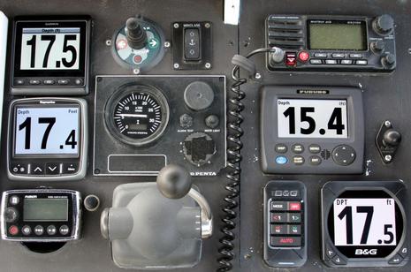
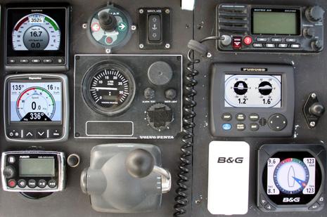
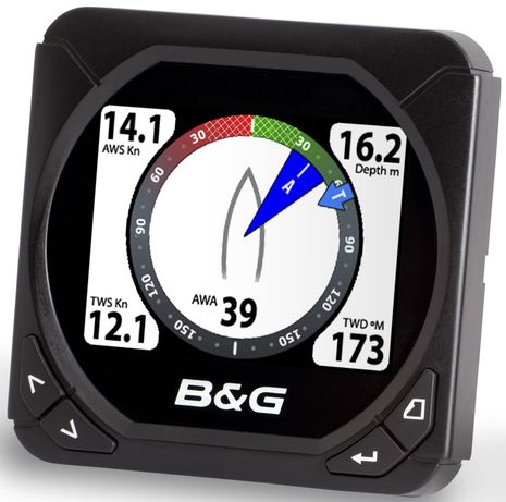
I’m embarrassed about how shabby Gizmo’s fly bridge electronics panel has gotten, but isn’t it great that with the arrival of the Garmin GMI 20 all four of the major manufacturers now have similarly large, bright NMEA 2000 all-in-one instrument displays? Oh, there are subtle differences on view — like how the Raymarine i70 seems to have a little less black/white contrast but also seems to have a slightly larger active screen, and how it and the B&G Triton nicely de-emphasize decimal depth — but the main thing is that many boaters can have a highly versatile display that matches your other Big Four brand gear. Or, since most of the data displayed arrives in a standard protocol, we have four quite competitive all-in-ones to choose from (plus N2K displays from Maretron and others). Of course there are many, many more subtleties and that’s what I looked for on the test GMI 20. I discovered some mysteries too…
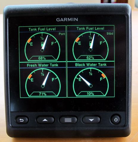
Above is the GMI 20 set to green night mode, which I find quite attractive (and which can be used during the day too since brightness is controlled separately). I like how the white needles stand out and I appreciate that some developer realized that I care about three of the tanks getting low and one getting full. But I was especially impressed with how Garmin handles the naming of tanks beyond the generic categories provided in the N2K standard…
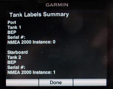
The GMI 20 not only gave me a long list of possible fuel tank labels like ‘Port’, ‘Center’ and ‘Aft’ but also summarized the finished labeling with N2K source manufacturer and instance info. This is the sort of nuance that will make installation and trouble shooting a lot easier, especially as more and more systems sensors get on the N2K bus. Of course the ideal is custom labeling, preferably done with a keyboard, but I’ve only seen that so far with BEP CZone, source of the tank level info, and with Maretron gear, which is doing digital switching and much more on Gizmo these days. But those custom labels only show up on the displays of the specific developer or partner, and even the fuel tank “Port” and “Starboard” designations possible with the Garmin GMI 20 and Furuno TZT (just discussed) do not travel around the network well. I believe that custom labeling is built into the NMEA 2000 standard but hasn’t been utilized; can anyone elaborate?
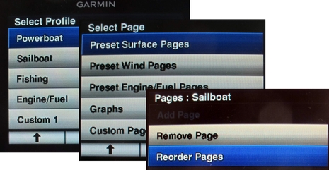
But I digress. Another nice nuance I noticed on the GMI 20 is Profiles, which let you pick a whole set of screen pages by boat type or your main data interest. Then when you customize a profile you can select from pre-built “fancy” screen pages related to surface, wind, etc. and you can also reorder pages within a profile. I’m not sure that any other manufacturer has made it so easy to set up the screen selection(s) you want.
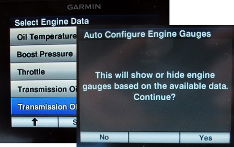
I don’t yet have Gizmo’s engine sensor data translating into NMEA 2000, but it’s getting toward the top of the to-do list and I suspect that the GMI 20 may be the easiest display to see it on. For one thing, the list of engine related data that it can display is long (which I also noticed on the Raymarine i70). Plus when I put an N2K engine simulator on the backbone (thanks again, Lowrance), the Garmin offered to adjust its fancy gauges screens (which were discussed when the GMI 20 was introduced). And when it saw RPM information, it asked if I’d like to enter the full throttle value so it could built its digital tachometer gauge to suit. Nice! (In my experience Maretron is the king of highly custom digital gauges, by a long shot, but they do take work and you won’t get fancy gauge clusters.)
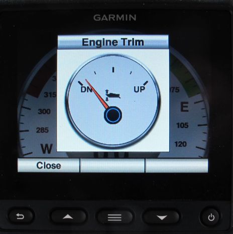
How about engine and/or trim tab pop-up windows, so the information is only taking up screen space when it’s changing? I think they were available on the original GMI 10 — as other of these 2nd generation display features may be, since it received LOTS of firmware updates — but does any other display have them? I also noticed that you can specify how much angular change triggers the pop-up and how long it stays up once you’ve stopped changing the angle.
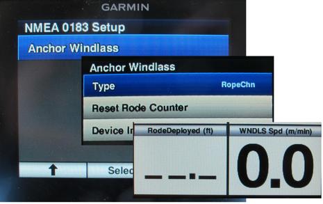
Now to the surprises. I’m pretty proud of sleuthing out the screens above. In regular mode the GMI 20 with its current software doesn’t mention its NMEA 0183 port. But in Demo mode there’s a setup routine for an anchor windlass and if you dig around you’ll also see related display values. So let’s be clear: the GMI 20 does not yet support windlass rode and speed display. But the evidence is strong that it will, and I’ve got a good hunch about the specific hardware/software that will make it possible. Check out the AutoAnchor 601 “Black Box” from Kiwi Yachting Consultants and recall that Garmin bought Nexus from the same company. So I’m also guessing that the 0183 port will eventually be used to integrate the wide world of Nexus sailing instrumentation with at least the GMI 20 and maybe beyond. (Unfortunately, it seems that the appropriate boast — “Elementary, my dear Watson!” — may be mythical.)
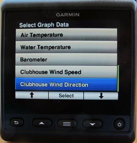
The last screen I don’t understand at all. What the heck is Clubhouse Wind? And if it’s a wind value from shore, like it sounds, how would it get to the boat? Will the GDL 40 cellular NMEA 2000 connection, as I’d hoped, finally be used for something besides weather (which it does well)? And why would you care what the wind was doing at the clubhouse anyway, if you have a clubhouse? I’ll close with a photo showing some of the fancy screens the different N2K displays are capable, some of which are unique (and should perhaps be copied on the others). If it ever stops raining here, I am going to do some cleaning and touch up that black paint.






First – labels are part of nmea 2000 – but only Maretron seems to use it. I do think Navico might as well as you can name your devices but I have not tested if that translates into nmea labels
And for clubhouse wind – one could hope it was reception of land wind measurements for club races. Not everyone has digital wind vane or airmar weather station. And Garmin Quatix need to get data from somewhere 🙂 it might not be 100% but better than nothing.
Very cool, Ben! Lots of good details there.
I might have asked this before, but are you able to compare the knockout/screw hole patterns between the GMI10 and GMI20 and let those of us with a bunch of GMI10s (6 here on M/Y Eden) know what carpentry would be required in order to upgrade?
Thanks!
/afb
Ben,
A “Clubhouse” instrument display is a wind display meant for use in a shore installation. Instead of showing wind relative to where the boat is pointing it shows wind relative to North.
Back in the days there was a Raymarine ST-60 display called the “Club House Wind Instrument”, see manual here:
https://flir.box.com/s/w7dp1h5hwi1f3fmda4x1/1/402191901/3273524497/1
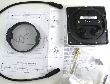
For m/y Eden, the GMI20 will replace the GMI10 with the same big hole cutout and same footprint, but you need to drill 4 new holes for the 4 screws that hold the GMI20 onto your dash. These 4 screw holes are in different postions from the 4 screw holes for the GMI10. Easy job and it takes literally 5 minutes to swap a GMI20 for a GMI10. I did it several times over last week on my boat.
Ben I have a stack of GMI20s flush mounted. They look great. How do I post a picture?
Thanks, Kees, that’s the best explanation yet, but I remain a bit dubious. The Raymarine Club House system just seems to be a somewhat cheapened ST60 showing True Wind. You can set that up with any N2K display, but I don’t know of any other value in the Garmin data lists that is just a duplicate of another value.
There may be more to the story, but if Garmin did that just to label True Wind (or what they call Ground Wind) as Clubhouse Wind, it’s good case for custom labels. The potential customer next door might want to display Tiki Bar Wind.
As for replacing a GMI 10 with a 20 it’s a two minute job if you have expanded PVC panels like Gizmo’s ( http://goo.gl/l25oB ) that take screws well (but that’s also why I have to touch up the paint frequently). One other change besides the fastening holes is a narrow round gasket instead of the larger GMI 10 one that tended to squeeze out a bit.
jfm, there is no way on Panbo to post pictures but if you send a selection to “ben at panbo.com” I might be able add one as PS and/or use them in future entries.
You could also put them up on a photo sharing site like Flickr and share the link with Panbo readers. Sorry it’s not easier.
Anyone know if there is a way of pressing the buttons remotely . In my application, the units are difficult to reach
Dave
I replaced my GMI10 with a GPSMap451s because my GMI10 died when I was in a remote location and the local shop only had the GPSMap. It was meant to be a temporary fix but it turns out to be significantly better at instrument display than the GMI10 and cheaper… and does a lot more. I would never put a straight instrument display on a boat again and would advise anyone thinking of it to think about the type of information they want to get and would even a bottom of the range MFD provide this.
Definitely an interesting approach, Dean. There’s no question that many small MFDs offer a lot of bang for the buck, I think due to volumn, competition, and the price sensitivity of the small boat market.
I looked at the 451s manual and see some gauges and flexible digital info screens. But if I were going this route I’d sure look at the newer generation, like even the EchoMAP 50s at $450 without detailed charts (+100) or thru-hull transducer (+150). Full VGA 5-inch screen, 10Hz GPS, AIS and chart plotter, Garmin DSC/N2K radio integration, fishfinder, and probably a pretty good level of data display. And “wireless connectivity”!
There’s a lot more to know with no manual up and no list NMEA 2000 PGNs but here’s the link:
https://buy.garmin.com/en-US/US/on-the-water/sounders/echomap-50s/prod119856.html
As to ClubHouse winds, wouldn’t it be useful to know the wind speed and direction as you come into home port for planning how you approach docking?
The Furuno RD33 shown on Ben’s original photo not only accepts both NMEA2000 and 0183 inputs, it will also convert each of those inputs into the other format and re-export…the same functionality as the NN3D system itself. Very useful in multi-manufacturer environments. Can the Garmin GMI20 do that?
Ben: really looking forward to the project of getting your (non electronic) engine data onto N2K. Hope in your usual way you will be able to test a couple of alternative approaches at least.
Hey Ben – Not to nitpick, but did you ever wonder why the RD33 shows 2 feet less depth than all your other instruments? Perhaps it’s connected to a different transducer, or calibrated for a different keel offset… just curious as I’ve had similar issues using different instruments (ST60, Actisense DST-2, Navnet3D, etc.) when it comes to depth.
The GMI20 looks very interesting, I just hope it comes with something more detailed than the 4 or 5 page “pamphlet” that Garmin uses as an excuse for an installation and operators manual on the GMI10…
At last! a Black Box chain counter! That’s wonderful, but, why did AutoAnchor use NMEA 0183 when the world has moved on to N2K? Wouldn’t it have been easier to connect a black box to an existing N2K network and instantly have the chain counter on the Garmin GMI 20?
Instead of recreating the rats nest of 0183 wires just for AutoAnchors chain counter, I guess I can use an Actisense NGW-1 and hook it up directly to N2K, (but at great cost). With a GMI-20 at the helm, seeing how much anchor chain is deployed would be a terrific addition.
Richard, I’m assuming the AutoAnchor black box uses 0183 because as far as I can recall from my last browse through NMEA’s web site, there is no NMEA2000 PGN for chain counting.
Perhaps the chain counter PGN was crowded out by the three PGNs reserved for LORAN data. 🙂
Thanks, Adam
That’s too bad since knowing the amount of chain deployed is a safety issue. I think NMEA should make establishing a PGN for anchoring a high priority. Also, my idea for using an NGW-1 would not work without a PGN to convert to. Well, no need to rush out and buy a new GMI-20 to replace the GMI-10’s.
Richard,
Garmin added 0183 support for the AutoAnchor device in version 3.2 of the GMI10 software, and enhanced it with ver. 3.5. If you already have the GMI10, I would say you’re good to go – just add the AutoAnchor device and connect to the existing 0183 connector of your GMI10.
http://www8.garmin.com/support/download_details.jsp?id=4819
Unfortunatly the GMI10 can only listen to one 0183 talker at a time, so if you have already connected a different 0183 device to that port, you will need to add a multiplexer to the system…
Thanks, Grant. That’s interesting because on the GMI 20 the AutoAnchor setup is only visible in Demo mode.
PS. Tried to get an entry up this morning but now it will have filed from a press tour in Korea!
Yes, it seems the GMI10 is designed to only display certain menus, when it senses the appropriate device/data on the network… I suppose this is meant to simplify things, but (in the absence of a comprehensive manual, PDF or paper, which I’ve whined about already) it does make it a little difficult to determine the full extent of it’s capabilities. I’ve pointed out this issue to Garmin before, but they apparently feel this is the correct approach…
Have fun in Korea!
Ben, if you haven’t yet updated the B&G Triton software, you should do so. B&G added a lot more functionality, displays and alarms – particularly those related to engines, tanks, trim tabs, etc. The concurrently released manual update doesn’t even cover all that is contained in the software.
Mark
hi Ben
just wondering does the new gmi20 have a dedicated anchor watch
regards morris
Not positive but don’t think so, Morris. It seems like the anchor drag alarm graphic seen on the Maretron and Vesper displays could be on any N2K display, but it’s not common.
I believe that the difference between true and clubhouse wind is the way that it is displayed. True wind is displayed as the true wind relative to the bow of the boat. Clubhouse wind is like a static clubhouse wind gauge, usually with North at the top.
In other words, the arrow at 90 degrees may indicate any direction of wind (depending on where the boat is pointing) in a wind instrument display but will always be East on a clubhouse display. It is kind of useful for an anchored boat so you can easily look and see if the wind has shifted.
Thanks, George, but that’s exactly how “Ground Wind” works on Garmin (and many other displays). The wind direction and speed is corrected for any boat motion and shown relative to ground, i.e. relative to planet earth and True North. In fact, many of us believe that this is the true True Wind, but we have already discussed THAT at length:
https://panbo.com/archives/2013/03/the_equinox_celestial_mechanics_pesky_true_wind.html
I know that I am a bit late on this but your can find some information about the EchoMAP 50s PGNs. I’ve noticed that Garmin often published PGN information in their installation instructions. http://static.garmincdn.com/pumac/GPS-echoMAP_500-700-50-70_INST_EN-US.pdf
Has anyone with a GMI20 verified what “Clubhouse Wind” displays? My thinking is a GMI20 would be nice as a shore-side weather station (wind, temperature, barometer) if it could display wind direction on a compass rose.
No verification, Mark, but here’s what the Raymarine ST60 Plus Club House Wind Display looks like
http://www.amazon.com/Raymarine-ST60-Plus-House-Display/dp/B000SMVK9A
Can anyone positively confirm that the GMI20 can correctly process an NMEA 0183 RMC sentence?
Paul, both the GMI10 and GMI20 list RMC as a supported sentence – it definitely works on the GMI10, I haven’t used the GMI20 yet…
-@Grant. Thanks, yes I know RMC is listed as supported in the manual. I’m asking if anyone has direct experience and can confirm their GMI 10 can in fact successful receive and display RMC information.
Anonymous (Paul, I assume?) – Yes, when I posted that it “definitely works on the GMI10”, that is from direct experience – the GMI10 supports and displays all elements of the RMC sentence, including Position, SOG, VTG, etc. As the GMI20 manual also includes support for that sentence, I would expect it to work fine as well…
Ben,
It was with great anticipation that I received the GMI20’s on our last project at the yard I work (Coastal Craft) because I knew we had a new 65′ project on the books. When it came time to spec that boats navigation system, I suggested we run a GMI20 for both wind data and to display the windlass/anchor data.
The wind sensor ended up vetoed, but the windlass interfacing made it through the design stage.
Turns out with some serious head scratching from our engineering department and Garmin’s that you can indeed get windlass data through autoanchors AA601 black box to a GMI20. It looks beautiful at the main helm to see that information displayed in a suitable format, alongside all the 8215’s and GHC20.
A vast improvement above the old round auto anchor display with its horrid two button confusing setup interface.
While definitely not an ‘out of the box’, plug and play convenience yet, it is possible and the end result is obviously nice to see.
I would love to know who is selling the AutoAnchor AA601, Black Box. Recently I called several retailers and Maxwell to try and find out if they could sell me one and how much it cost. Not a single call I made resulted in a call back and no one knew anything about the AA601. I wonder why Garmin put so much time and money into developing software for the GMI-10 & 20’s when AutoAnchor does nothing to promote their Black Box Chain Counter.
As I mentioned in a post above, knowing how much chain is deployed is a safety issue. AutoAnchor and Garmin have the most convenient way for checking this and there is no competition. What a missed opportunity.
@Grant. I confirmed (via a bench test) that the GMI-10 is unable to process an RMC sentence from NMEA 0183 versions earlier than 2.3. Garmin has been aware of this issue for nearly a year now and I have no indication that they intend to fix this any time soon.
The GMI-10 has issues processing older versions of NMEA 0183. I would advise anyone looking to use the GMI-10 or GMI-20 with older 0183 to carefully check for correct operation with your kit.
Richard,
We purchased it directly through Kiwi Yachting / Auto Anchor. If you check the Auto Anchor website they show a pretty decent level of distributors.
I know from dealing with people in the company directly that Peter Woolf and the guys there are a fairly small company but seem more than ready to stand by their product and support installers with what they need.
I do not know if ‘missed opportunity’ is intended by either party or if it is just a case of Auto Anchor not having enough resources to promote it to the yachting community at large with significance from New Zealand. From the Garmin side I think it is more of a situation where it is still such a small part of the larger demographic that would be thinking along those lines of integration.
I installed two Garmin GMI 20 displays on my sailboat and tried to update them this week with the 4/21/14 v2.20 software using my Garmin 740s chartplotter. Both of the GMI 20s appeared to go through the motions of erasing the old software and taking the update showing 100% on the 740s. However, when the GMI 20s restarted they came up with a “software missing” message on the screen. I updated them both many times using the 740s and a Garmin special update module and both continue to say software missing. Anyone out there seen this and solved it?
Hi Michael,
Garmin wants you to know that your problem can be fixed without sending anything in for repair. They suggest that you call the product support line 800-800-1020 (and he/she can hit prompt 2, then prompt 4 for marine support).
Other readers may be pleased to hear that I too just updated my Garmin system, using a 741 instead of 740, and the GMI20 on the network updated fine.
Ben:
I am trying to decide between a GMI-20 or a DMS250 for a display in the cabin. Primarily use is when I am anchored out. Wind speed and angle and weather info are important. A wide viewing angle is important because of my mounting options. The GMI-20 lists a 170 degree viewing angle but Maretron doesn’t list or know theirs. Is it comparable?
An anchor alarm would be an advantage but the Maretron requires that you press the position when you drop the anchor to set the alarm and with it in the lower cabin that would be a problem. Can the a 4208 Garmin pass along its anchor alarm info through the NMEA 2000 network? Maretron says not on theirs.
I did find out that the DMS250 past S/N 1320800 have an “enhanced” display.
thanks
Before I purchase three new GMI20 displays for my cruising yacht, can anyone confirm/deny that they will receive and display NMEA0183 wind data from my “old-tech” Navman masthead unit. It is far more robust than the new matching Garmin unit. It is also easily removed from it’s masthead base mount with the insertable pin-plug connection.
Gus L, Hobart, Australia.
Sorry, Angus, I’m not familiar with the Navman wind instrument, but are you sure that the masthead unit is outputting NMEA 0183? Much more typical would be a masthead unit sending analog data to a display that then might output the translated data in 0183.
Ben the weather here in Penobscot Maine is probably like the English Channel last few days. As per your recommendation just finished install of Actisense EMU 1 and it went quite well. Especially after updating firmware and control software. Now I can monitor engine temp and oil pressure while sitting on pilot house settee. Now to connect 4 fuel tanks to it which is a new feature they just added. New Garmin Gps 19X gives me 6.5 foot accuracy. Wow!
See ya soon.
I was able to get the update to work by disconnecting everything else from the NMEA 2000 network other than a single GMI 20 and my 740s chart plotter. Must have been some interference from something. All is well now and very happy with the units.
If you’re GMI20 dies after a software update — just showing “system missing” on its screen — check out this special key sequence to get the GMI in “bootloader holding” mode: http://goo.gl/N6l93c
Why am I bringing this up today? The latest 20120630 network update did the nasty to Gizmo’s test GMI20, even though an earlier update suppossedly “Improved reliability of NMEA 2000 software updates.” Be careful out there 😉
I was able to resuscitate the test GMI20 but things didn’t go exactly like Garmin’s instruction. The GMI20 never showed the message “Holding bootblock” but I tried updating anyway and it worked. Note that the GMI20 must be completely off when you start holding down the Back button, which may mean no power on the N2K backbone (what worked for me).
Thanks for the great review…… but can you help me decide…..
GMI20 or i70????
@Grotty. I’d add the Triton t41 to that list. All else being equal, go with the manufacturer of the rest of your electronics kit. Sensor calibration and firmware update typically does not work across manufacturers.
Thanks for that Sparky, I’ll check it out. I like the i70, but still haven’t quite got my head around “seatalk” so tempted to go with straight NMEA 2000…..
Hi. Is it possible to feed GMI 20 with my Garmin GpsMap 76 via NMEA 0183????? Will GMI 20 show me BRG, COG, SOG, XTE, ETA, etc.???
Another question: I have an old SILVA 220 log instrument with his own speed transducer. I think is very similar to the Nexus TH43 that was replaced by Garmin with de GST 43 thru-hull transducer. Could GST 43 talk to GMI 20 via NMEA 2000????
Thanks.
Hi Esteban,
Jon Josephson from Garmin sent me these comments regarding your questions:
“The GST 43 is designed to directly replace the 43mm Nexus log which does go all the way back to the Silva 220.
So yes he can take a new GST 43 bundle 010-04282-00 and connect it to NMEA 2000 and the GMI 20 will display speed from the transducer via NMEA 2000.
https://buy.garmin.com/en-US/US/prod513029.html
Ok now for the good news bad news.
Bad — The GMI 20 will not support both NMEA 0183 and NMEA 2000 at the same the time meaning that the poster will not be able to connect his GPSmap via 0183 to the GMI20 and also have his speed data from the GST43. Yes the GMI20 does accept NMEA 0183 but it cannot accept both NMEA 0183 and NMEA 2000. It’s a limitation which in like 99% of all the applications the GMI20 will be use hasn’t hurt sales.
Good — The GNX20/21 however can input GPSmap data via 0183 and also display NMEA 2000 data like the speed data from the poster’s new GST43. This poster should go with the GST43 and everything will work fine.
The accepted NMEA 0183 sentences and the NMEA 2000 PGN list is found on the last page here
http://static.garmin.com/pumac/GNX_20_21_Install_Instructions_EN.pdf
Ben, thank you very much, your answer is very helpful.
So, GMI 20 is not able no receive both 0183 and 2000 at the same time. But if I use Actisense NGW-1 to convert GPS data into N2K???? Would it work properly?
Tks again.
Has anyone figured out how to display exhaust gas temperatures on the GMI 20? I have this data on the NMEA network courtesy of a Maretron TMP100 module.
Thanks in advance.
Evan
Hi Evan,
I don’t have exhaust gas temp on Gizmo but I notice on page 10 of the TMP100 manual that Maretron apparently had to use a proprietary high range temp PGN to handle exhaust gas. I’d suggest asking Garmin to add support for the value — they do seem to support more and more PGNs — but they probably can’t for a proprietary one.
Another thought is ask Maretron tech support if there is some workaround, like maybe categorizing the exhaust temp as some temp that Garmin does recognize.
Finally, just yesterday Maretron announced a new DSM410 color display that would match the GMI20 fairly well and do all sorts of powerful things with your data:
https://www.maretron.com/products/dsm410.php
*
Evan – as Ben said, you’ll probably need to call Garmin. You might ask them to consider updating this document as well:
http://static.garmin.com/pumac/Tech_Ref_for_Garmin_NMEA2k_EN.pdf
The GMI20 “manual” provides no PGN information at all, and their “Tech Reference” for NMEA 2000 is dated 2012 – it doesn’t even include the GMI20, only the GMI10.
The proprietary PGN Ben referred to is 130823. There’s about zero chance Garmin will support that. But Maretron also lists 130316 (Temperature, Extended Range) which may contain the data required for EGT.
I might start with Maretron and ask them that question first – they’re pretty good with phone support. If the EGT data is contained solely within 130823, you might as well skip the call to Garmin (except to remind them their N2K manual is 5 years out of date…) 🙂