
Garmin & Navionics part 2, a close look at ActiveCaptain the app
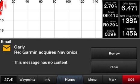 It’s odd that I was writing about the Navionics Boating app’s excellence at MFD integration when Garmin purchased the company and downright weird that the acquisition news arrived via a beta version of the brand new Garmin ActiveCaptain app that takes MFD integration to some other excellent places. For instance, have you ever seen phone notifications pop up on your helm screen while you’re underway (if you choose)? The two apps are good news for lots of boaters as they are right now, but what fun to think of all their key features made into one…
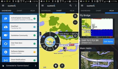
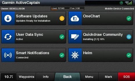
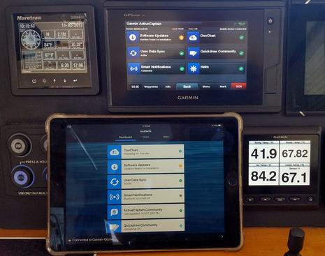
Let’s start with a peek at the three major tabs in the free Garmin ActiveCaptain app, as seen above on my Android phone (click the image larger for more detail). The Dashboard offers a set of utilities like setting up the novel Smart Notifications, as well as familiar tasks like Software Updates that used to be much harder to do. Using and/or sharing QuickDraw crowdsourced depth data also got a whole lot easier, and more.
Meanwhile the Chart tab is very much like the BlueChart Mobile app Garmin introduced in 2012, except the weather features are not included (yet). On the other hand, the charts, which allow you to plan trips wherever you are now, cost nothing, as long as you already own the same area on a compatible WiFi-enabled Garmin display — a major feature called OneChart.
And finally the Helm tab is just like the standalone Helm app that has long allowed Garmin owners to view and control their WiFi MFDs with their phone or tablet when on the boat. In short, when Garmin touts ActiveCaptain as an “all-in-one” app, they are not exaggerating!
 Here’s what the new ActiveCaptain page looks like on a Garmin display, in this case a GPSmap 742xs. Note that ActiveCaptain the app is very much about integration of mobiles with Garmin marine electronics, and so far not particularly about the excellent ActiveCaptain crowdsourced cruising information many of us associate with the name. In fact, the app has been in development at Garmin for three years, and Garmin only acquired ActiveCaptain last May.
So while the info that’s now called the ActiveCaptain Community is fully available in the Chart section of the ActiveCaptain app, just as it was in BlueChart Mobile (BCM), AC data does not (yet) appear on AC-enabled Garmin displays, and other aspects of the old AC, like eBoatCards, remain solely on the recently overhauled ActiveCaptain.com site. It seems very likely that more merging of the two ActiveCaptains will happen, but, for now, Garmin just seems to have used the good name.
The bigger picture: ActiveCaptain the app is a bundle of goodies that most every Garmin boater — cruisers, fishermen, racers, etc. — will want to have, even if they only use a few features. However, some setup work is required.
Installing ActiveCaptain
 The years of development Garmin put into the ActiveCaptain app and hardware integration are probably why all its aspects have tested quite well for me so far, and Garmin also took the time to build feature explanations and setup guidance into all the platforms. Nonetheless, you have a few tasks to complete before reaching the AC happy place.
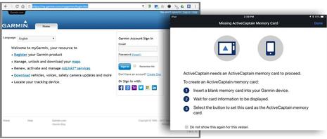
Besides simply installing the Android version of ActiveCaptain or the iOS version — already submitted to Apple and due any moment on iTunes — you’ll need to remember your MyGarmin login credentials. You can also register a new account when you open the app, but traditional AC users should note that the email and password asked for are not the ones you registered at ActiveCaptain.com (though that may change eventually).
Also, once the app is running and you’re ready to try the MFD integration, you’ll need a blank SD card which the system needs as a waystation for all the data you may transfer back and forth. And make it a large capacity card if you plan to download lots of charts onto your phone or tablet — especially BlueChart Vision style satellite maps and aerial photos (yes, they work) — because the app will automatically copy such OneCharts to the AC card on your MFD in case they are fresher than what’s already available on the boat system.
And you, too, may be pleased to find that some of your already owned charts will get updated for free once ActiveCaptain is fully up and running…but there is one more step.
 Making the ActiveCaptain connection is a horse-before-the-cart situation for boats with existing Garmin WiFi displays; you need to update the displays the old way before enjoying the new way. For my GPSMap test system, that meant downloading a huge 1.6 gigabyte file to a PC, unpacking it, copying it to an SD card — or buying the card — and finally installing it. It’s tedious, and may take your home or office Internet connection, but relish what’s coming – shown below.
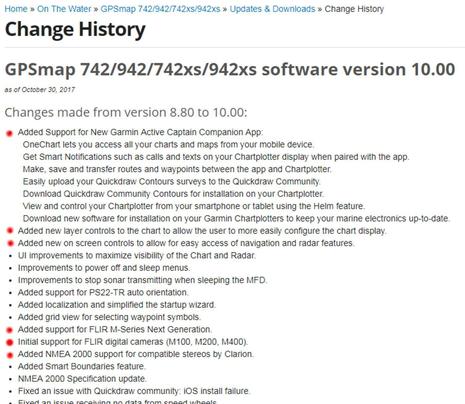
And note in the GPSMap version 10.0 details above that Garmin did not just add support for all the ActiveCaptain features. The MFDs now also offer some valuable new chart and radar interface features, they support the FLIR M232 thermal camera and Clarion CMS4 stereo system I’m happily testing, and several bugs have been squashed. Which is why super easy ActiveCaptain electronics updating is great news.
Software Updates
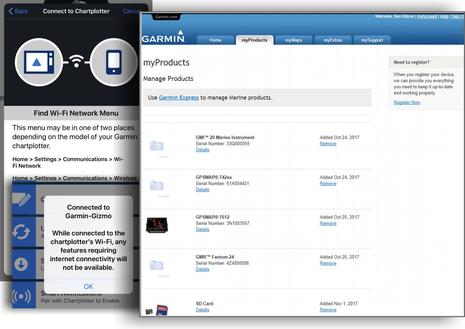 The magic starts to happen once your phone or tablet running the ActiveCaptain app is connected via WiFi to your updated-the-old-way (or new) Garmin MFD. The app will guide you about making the connection if needed (as shown above), and you will also get warnings about how some functions need you to switch back to a WiFi connection with the Internet. In fact, there’s apt to be a lot of such back-and-forth switching at first, though the rewards are great.
For example, the bigger screenshot above shows that Gizmo’s Garmin test gear is now registered at MyGarmin, which happened automatically because the MFD passed the details to the AC app which then passed them to Garmin’s servers. Easy product registration is a good thing by itself, but those same servers now use the data to gather specific update files for Gizmo’s system and send them back through the two-step pipeline.
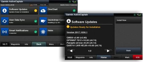 Voila! This update happened nearly by itself. While I had the ActiveCaptain app open on my iPad or phone, perhaps planning my next cruise, the update was automatically downloaded in the background (if the mobile was online). And the download file size was a small fraction of the 1.6 gigabyte SD card method, because it was customized. Then when I next connected to the Garmin WiFi on the boat, the updates file was again automatically transferred, and I would have been prompted about installing them even if I didn’t open the AC pages above.
By the way, one AC integrated system can fully support two mobile devices. I can work with My Charts and do other tasks on either phone or tablet (and other AC app users can access my hardware as guests, if I permit).
Now, in a way, Garmin is playing catch up with this new software updating system. Navico, Raymarine, and Furuno already offer direct-to-MFD updating via WiFi, which can be even easier. But there’s something to be said for the two-step method with a mobile as the intermediary (which I’ve also appreciated as part of Vesper’s big Smart AIS evolution). Boat WiFi is sometimes too flaky for big downloads, and with apps like ActiveCaptain there’s so much else available that the software updating just seems to happen.
OneChart
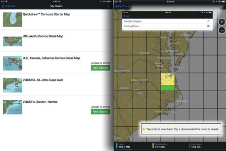 OneChart works in a similar way. Once you’ve gone back and forth between MFD and Internet WiFi, the Garmin servers and your app will know which built-in charts and chart cards you already own, in other words which OneCharts qualify for your My Chart list. Note that the two Bluechart Vision cards seen on my list above had to be inserted in the MFD during the process, but note also the free update for a card that’s three years old.
Once your chart list is established, you can select any region/version and download data by cells. The cell I’m downloading above is from the standard built-in U.S. coastal charts and totals about 225 MB. The same cell from the updated Boston-Norfolk Vision card is about 440 MB because of its aerial photos, extra POI info, Fishing Charts and so forth. And If I enable Satellite Imagery in the chart download settings menu, the same single cell Vision file goes above 1 gigabyte.
Now it’s easy to delete chart cells or stop downloads with a double tap, and the app page clearly tells you what’s going on with your mobile’s memory, but you might want to increase memory on your next mobile. It also may be wise to oversize the ActiveCaptain SD card since the charts you download copy there, too. If some free annual updates are available now — and the ActiveCaptain app also lets you purchase new charts for mobile and MFD — consider the fact that Garmin now owns the Navionics technology that updates its entire chart database every night.
Quickdraw Community
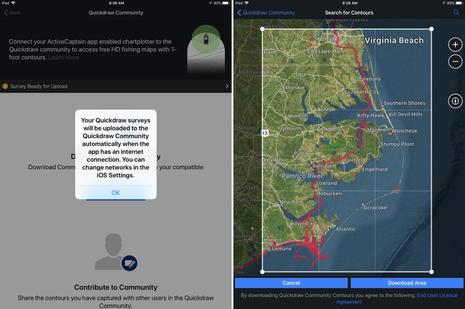 If you’re still with me, it’s probably obvious how ActiveCaptain makes Quickdraw user-collected depth information easy to display on your boat and to share with other fishermen, and/or with other cruisers who hopefully use it as a secondary reference to official chart data. Note that you can keep your own bottom data private while still downloading Quickdraw files shared by others, as I was doing on the right-hand app screen above.
It’s good to see that at least one boater has already contributed Quickdraw data for the ICW section Gizmo will be traveling after some service work at Atlantic Yacht Basin, though shoaling hazards along the route are already well covered by the AC Community, the Waterway Guide, and the Salty Southeast Cruisers Net (my review of SSECN app here).
So I was particularly glad to see Quickdraw data for some of the tricky waters inside Cape Lookout that I hope to cruise for the first time, if schedule and weather permit. Heck, I’m hoping that good planning, charting and sonar tools, along with shared local experience, mean that a fairly deep draft boat like Gizmo can gunkhole up through Core Sound to Ocracoke National Park, and it’s high time I use the same tech to help put some fresh fish on the boat menu.
The quantity of shared Quickdraw sounding data should certainly increase rapidly now that the ActiveCaptain app makes the two-step upload automatic (if you choose), but, wow, what does it mean that Quickdraw is now under the same roof with all the crowdsourced and other non-official bathymetry data collected in Navionics SonarChart? To be discussed.
EchoMaps & Strikers too
 What I’ve been describing is how the new ActiveCaptain app integrates with bigger boat Garmin system like Gizmo’s, but the company seems intent on offering the benefits across their marine line. So WiFi and AC compatability is included in almost all of the new EchoMap Plus plotter/sonar combos introduced last week and even in the new Striker Plus sonars (with GPS and Quickdraw).
That means a small (or budget) boater who purchases a 6-inch EchoMap Plus 64cv for $450 (plus install and transducer costs) will also get whichever of the phone/tablet features they’d like to use. That’s quite a large chunk of added value, and another reason why I think that the ActiveCaptain app is a big deal.
Happy Ending
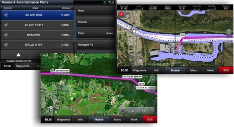
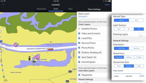 I’ll end with illustrations of how I can now use the ActiveCaptain app to plan routes I’ll use underway on Gizmo’s Garmin helm displays, much as I’ve recently enjoyed using the Navionics Boating app’s Plotter Sync with Simrad and Raymarine displays. On the iPad screen above I’ve got the AC app’s Chart tab open and showing a OneChart area I downloaded, and the setting menus suggest a lot of flexibility about how the data is presented.
This happens to be a BlueChart Vision chart, but ActiveCaptain Community marina, anchorage and other cruising information shows on any OneChart or the app’s basemap as long as it’s been separately downloaded (with frequent updates automatic if you choose). Somewhat oddly, you cannot currently edit AC info in the AC app — you get sent to activecaptain.com instead — but I suspect that will change soon.
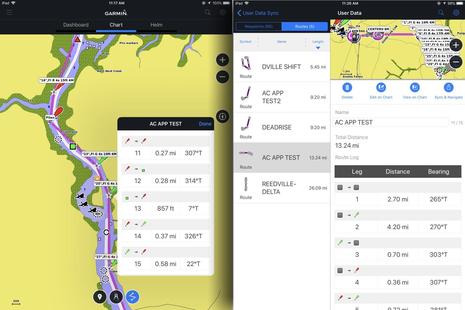 On these screens I’ve fingertapped a short ICW route which is then displayed in the app’s User Data Sync section. Using Navionics’ Dock-to-dock autorouting is a lot easier, especially in twisty areas like this, but, then again, I took advantage of a Garmin feature I’ve long liked: If you tap a waypoint on a navigation aid, the waypoint gets the aid’s name and characteristics as its name, even the same symbol. The result is not necessarily a route you’d follow closely, particularly here, but it can be a useful reference about what to look for next and where.
Note upper right that if the iPad is WiFi connected to the Garmin MFDs, I could instantly Sync & Navigate this route to the Garmin MFD system — just like I learned to love with BlueChart Mobile in 2013, and still a somewhat awkward process with Navionics Plotter Sync. But with the AC app, all routes and waypoints are also auto synced to the MFDs.
 So now I’m building a list of easily-edited-anywhere Garmin routes and waypoints that’s synced to boat electronics, phone, tablet, and probably somewhere in Garmin’s cloud (GPX export/import is also built into the AC app). That’s motivation both to navigate more carefully and explore more freely, and whereas similar app/MFD integration is also available via Navionics and Raymarine/Simrad, have we reached an evolution point in boat navigation?
Add all the other ActiveCaptain app features, plus the fact that Garmin’s various charting and routing strengths will likely be abetted by Navionics’ accomplishments eventually, are we at a turning point in the marine electronics industry? I’m not suggesting that any big brand is going away, but it does seem like the challenge has increased, and I suspect the lights are burning late at certain research and development centers.
It would be great to hear how readers fare with setting up ActiveCaptain — the Apple iOS version just became available — or any thoughts where these apps and the Garmin/Navionics pairing is headed.


The AC App is of little use to me since I run Furuno gear. The app’s base map is so coarse that the AC Community data is hard to interpret without buying OneCharts and those are stunningly expensive (~$2000 for our cruising range) compared to our now-discontinued BCM install at $50. My MaxSea Navigator does all the PC integration I need for planning and nav station work, fortunately Garmin has not cut off Furuno’s access to the AC Community database. I am going to have to get better with OpenCPN.
I agree, Royce, the ActiveCaptain app is aimed squarely at Garmin MFD owners. The OneCharts are more expensive than normal phone or tablet charts because they also run on a boat’s chartplotting screens.
BlueChart Mobile was arguably better as a standalone planning and AC viewing app, but I gather that it will keep operating though no longer for sale.
Plus I like the ActiveCaptain Community info display on the Furuno TZT2 — the only instance of AC on an MFD there is, I think — and I look forward to easy route/mark sharing with the TimeZero iPad app as well as the TZ PC programs like you’re using. It seems like mytimezero.com has been in the works a long time, but maybe this new Garmin move will light a fire 😉
PS It’s quite subtle, but that last photo illustrates how polished most of the ActiveCaptain app integration already is.
It’s not a glitch that the MFD says that Smart Notifications is connected while the iPad AC app says that Smart Notifications Bluetooth is turned off. It’s because Smart Notifications operates independently and was connected to my phone when I took this photo, just like I want it. Slick.
Ben,
Is there a way to use Active Captain data with a more detailed base map if the boater doesn’t have Garmin electronics or expensive OneCharts? In other words is there any way the AC data contributed by previously open crowd-sourcing boaters can be overlaid on free detailed charts?
Like a whole lot of folks, I have Raymarine on my boat. so I’m a bit concerned.
I use the Navionics’ iPad app to cross-pollinate the routes and tracks and to download charts from the net and update the charts on the MFD.
I only use the Garmin BLue app for AC and as a secondary set of charts (on our almost 3,000 mile jaunt up and down the east coast last year the Sonar chart beat Garmin hands down at almost every inlet and tight/shallow spot) Lots of apps offer AC so that’s not at issue as long as AC continues to be offered that way.
My worry is that EVERYTHING you mentioned above is obviously directed at the full compliment Garmin user.
so LOTS of questions:
Will Navionics (in that name or Garmin?) still offer the same/similar charts, compatibility, transfer, etc and pricing that I get now?
Will “Sonar” charts go away or get better with the addition of Garmin’s crowdsource data? Will Raymarine users still be able to upload data to Navionics/Garmin?
The Garmin chart pricing schedule seems quite a bit pricier than what I pay for the charts on both my Navionics app and my Raymarine e125.
Basically, although there are nuanced issues, just what’s going to happen to the Raymarine users that use Navionics charts on the dash and Navionics app on an iPad?
Curiouser and curiouser….
Anon, here’s a 2014 Sail magazine roundup of nav apps that includes four apps — besides BlueChart Mobile — able to overlay ActiveCaptain data on detailed charts. Note the spreadsheet link at the bottom.
https://www.sailmagazine.com/diy/navigating-the-app-world
I must say that by naming their all-in-one app ActiveCaptain, Garmin made finding other apps that support AC harder.
“on our almost 3,000 mile jaunt up and down the east coast last year the Sonar chart beat Garmin hands down at almost every inlet and tight/shallow spot”
Doug, that’s a very interesting report, but it worries me a bit. It probably doesn’t apply to you, but I’ve learned that some experienced cruisers are using Navionics SonarCharts for primary navigation, which sometimes works out badly. Example here:
http://svcrystalblues.blogspot.com/2017/09/navionics-sonar-charts-missing-reef.html
In my view, crowd-sourced depth info like SonarCharts and Quickdraw are only meant to be used in addition to charts based on official data (if available). They may look more detailed but as SV Crystal Blues found out, major features may be missing. But then again, there were many ways Crystal Blue could have avoided that grounding.
At any rate, I’m planning an entry on this subject and would appreciate examples of where you found SonarCharts better than Garmin or other regular charts. Please email to ben at panbo.com. Thanks!
Doug, I’d like to answer your questions about what will happen with Navionics, Raymarine, etc., but I simply don’t know. Actually, I doubt that even Garmin has much of a plan yet.
It does look like Raymarine will be squeezed because because the three major commercial chart brands are now owned by two of their competitors. But maybe Raymarine has a pathway simply because it is not Garmin or Navico (Furuno too). Maybe Garmin/Navionics and Navico/C-Map will compete to sell their chart products to Raymarine, Furuno, and others???
Also consider how independent Fusion still is, though acquired by Garmin in 2014. I still deal with the same management and marketing people, and some sensational new Fusion gear coming next year does not seem to have significant Garmin hooks in it.
The iPad and iPhone version of Garmin ActiveCaptain just went up at iTunes:
https://itunes.apple.com/us/app/garmin-activecaptain/id1116089313
There’s quite a bit of hand wringing about the demise of BlueChart Mobile on the ActiveCaptain Facebook page:
https://www.facebook.com/groups/activecaptain/
Maybe Garmin should have kept BCM alive longer…
Hi Ben,
Cooling our heels in FL while Atsa gets her tanks replaced in VA..
For us RayMarine/Navionics folks, this doesn’t look very useful to me – if I access AC online thru my fone, it’s a bit cumbersome, but the good maps and sat views are available (assuming I have connectivity). Since I won’t be buying any Garmin Bluecharts, the ap looks non-useful. I sure wish it were, though – I really would like access to that treasure-trove while underway (and the laptop is secured).
WRT Navionics Sonarcharts – I’ve used them in lots of places, and been led badly astray a couple of times. In the Bahamas, everyone seems to follow the same courses, so the only spots that get Sonarchart data are along those lines – which leads to some bizarre displayed bottom contours. In a couple places where I strayed off the guidebook lines, I noticed that the off-the-line data got better after I sent in my logs. At Jackson Creek in the Chesapeake (Deltaville) the Sonarchart thinks that good water exists on both sides of the Red 10 mark – which is emphatically NOT the case! I’m guessing that error occurs because folks make a 90-degree turn at the mark, and the software smooths their depth reading to make it look like you can go either side. In Maine, we found a couple coves/rivers with utter BS shown in the Sonarchart.
To be fair, there were a number of places where Sonarchart offered excellent info – but until you test, you can’t tell ahead of time.
Right, ActiveCaptain the app is for Garmin WiFi MFD owners. For cruisers just wanting ActiveCaptain information on their tablets or phones even when offline, there are numerous other apps, still listed at activecaptain.com:
http://activecaptain.com/help/apps-index
I guess that the folks who used Bluechart Mobile without Garmin integration are now an opportunity for other app developers 😉
Ben,
For those of us with an investment on Bluechart Mobile charts, the main question is:
«For how long will we be able to re-download our paid charts to the Bluechart Mobile App?»
For example, the NW Europe chart was $109. Say, the iPad on which I had it bit the dust last week, so I got a new iPad Pro 12.9. As of last night, one can go on the App Store > Purchased, and find Bluechart Mobile and re-download the app. The app looks excellent on iOS 11.0.3 on the very large screen. Excellent.
But Garmin needs to disclose the date at which re-downloading the paid charts will be sunset, and they have not done this.
Not very respectful towards your paid customers, Garmin!
Ben,
Thank you for pointing out the quirks and features of Garmin´s new connectivity solution.
It is really odd having to change your mobile´s connection back and forth between MFD and Internet. I´d prefer to connect the MFD directly to the boats wifi or marina wifi instead. Btw the Garmin Oregon 700 series does already connect directly to the internet via wifi (or via bluetooth and your mobile) to sync tracks or get updates. The Oregon is always a step ahead.
I hope we will see ActiveCaptain crowd data and/or Navionics CommunityEdits on Garmin MFDs soon. That will be interesting.
Two questions:
1.
On your screenshot a software update is offered for your GPSmap 7612 from v9.74 to v10.00. Where did you get v9.74. Afaik the last version before 10.00 was 9.20?
2.
Did I get it right? If you register your Bluechart G2 to the AC app, you get lifetime free updates of this map as OneChart?
John, I agree that it would be great if the Garmin system could join my boat’s WiFi local area network (LAN) and allow other devices on the LAN to access it. Then my PC, phone, iPad etc would all stay on one WiFi access point and would have Internet when the LAN did.
But apparently it’s not easy to do this with large marine networks that weren’t originally designed for contact with the outside world. Furuno does support it, Raymarine sort of does, and Navico let’s its MFD systems either be a WiFi client without access or an access point.
I imagine this will change.
Your questions:
1. v9.74 was the beta MFD software that let me and others test ActiveCaptain before release.
2. I didn’t say anything about “lifetime” updates and I don’t know the Garmin chart update policy. But when built-in charts or chart cards get registered via the AC app, whatever updates you’re eligible for become available for download, as shown on my app chart list.
Hi Ben,
Understand your concern. I’ve been cruising the East Coast, the Bahamas, the Carribean and the Med for over 40 years so I long ago learned to be extremely suspect of ANY single source of info. Hell, I still have my Tamaya Spica onboard! 😉
Last year, both N and S bound, before each day’s run, I’d look at the latest ENCs, Blue Charts, Navionics, and Sonar charts while carefully reading the most recent comments (meaning those by the folks that are obviously competent) in ActiveCaptain for the route.
That due diligence showed me that in most of the AC noted tight spots the Sonar charts stood me in far better stead than all the other choices. Including a couple of places where Garmin Blue Chart showed us “aground”. At only one spot (at either Shallot or Lockwood’s, I’ll check my logbook) was the Navionics worse than the others.
Early in the N’bound trip in St Augustine, I was talking to a great Navionics tech guy about an unrelated issue and I pointed out a spot where ALL the charts had me “aground” where I had 9 feet under our 5′ keel, hugging the green side south of St A and north of Matanzas by following the AC comments of Bob243.
That tech quickly put me in touch with some of Navionics’ charting guys who checked my depth track and, low and behold, four or five days later there was 11′ MLW showing at the spot we’d been showing aground with the channel showing almost exactly where the AC reviews put it.
The most important thing the chart group did was warn me that when you see straight sectioned, angled depth contours in the Sonar charts instead of normally smooth curved lines, be very wary since those angled lines mean very, very few data points to smooth the contours. Nice to know.
Admittedly, mine certainly isn’t a mile by mile survey since we went offshore for some stretches where I didn’t want to bother, like Jekyll and Cumberland in GA N’bound and had a fantastic two night sail offshore from Hilton Head to Ft Pierce when S’bound.
While we had no problems with Navionics charts and Sonar on the East Coast, from the rumor mill I’d be reticent to use them in the Bahamas. But since we cruised there for many years pre GPS, with nothing but decades out of date UK HO charts, the Yachtsman’s Guide and some well tuned eyeballs, I’m not too worried for our upcoming trip. I DO so much prefer cruising where you can SEE the bottom! ;-).
It is disappointing that those of us who have recent Garmin Chart plotters, still for sale at the Garmin Store,,such as the Garmin 1040sx has very limited usability with the new Active Captain app, vs the 1042sxv for $1,000 more, has all of the features. I am told that the older models (such as 1040sx) cannot be updated via software. Yet we hear that Garmin has been working on the App for over 3 years!
There is no way to put a chart on the new “Garmin Active Captain App” except thru the registration of a chart plotter; thus the chart part of this does not really replace the Garmin Blue Chart App. I also wonder how long this will be supported–having just bought a set of charts for the Blue Chart app last week….Fortunately I got the Garmin Blue Chart app on my new I Pad Pro before it disappeared.
Bob, That’s a bummer about the 1040sx, which has WiFi but does not make the ActiveCaptain compatibility list:
https://support.garmin.com/search/shopResults.faces?filter=0&contentType=Shop&q=activecaptain+app
I think what happened was that Garmin made some big changes to the underlying operating system and networking over the last few years. I’ve noticed other odd-seeming incompatibilities, like the old wireless remote having to be replaced with a very similar remote. I think you can see the step change in these compatibility lists:
https://buy.garmin.com/en-US/US/p/8620#devices
https://buy.garmin.com/en-US/US/p/508142#devices
I have a very recent experience with diversity of navigation equipment that I thnk can be very informative. My wife and I are moving our sailboat down the East Coast from Deale Md to Stuart, FL, and we spent 2 days offshore starting this past Monday, from Morehead City to Brunswick. Just after noon on the first day, our Raymarine C80 chartplotter rebooted itself and all the charts went away. Everything else on the plotter continued to work (AIS, autopilot control, radar, waypoints), but all we had was the US basemap.
Luckily I have a Galaxy S8 phone that has two standalone charting programs, plus a full set of ICW paper charts, plus two different chart programs on my PC. I basically navigated for 2 days using my C80 to go to waypoints along the coast, and watch out for traffic, while the
phone showed me where I was on the charts.
I actually like to have the two devices, because one can show a zoomed-in image for work along the tight channels in the ICW, while the other can be zoomed out to provide perspective about what is coming up.
The real lesson, however, is that the Navionics chart chip failed, and I have no backup for it whatsoever. Kudos to Navionics for leading me thru the process of figuring out that the chip itself had failed, and
for letting me know that I could take another spare chip that I have, with European charts, and re-purpose it/download US charts for the rest of the trip down the ICW. Navigating the ICW with just a phone is not
easy.
So, I would say that this is important – have multiple sources of data available to you. Have multiple GPS equipment (I have, I think 8 GPS recievers on the boat). Multiple chart plotting equipment and probably
software. And, if you can, make sure you have paper available, and can still read the paper, steer, and do the piloting with your Mk I eyeball sensor. Even if the paper is 20 years old, you should be able to stay out of trouble if you are careful.
Oh, and the depth sounder is your number 2 instrument (sometimes No. 1), after the GPS.
(Reposted after a bounce because of my yahoo.com email address)
> But apparently it’s not easy to do this with large
> marine networks that weren’t originally designed for
> contact with the outside world. Furuno does support
> it, Raymarine sort of does, and Navico let’s its MFD
> systems either be a WiFi client without access or an
> access point.
Actually it is pretty easy to write the software to allow a device to be either a server or a client. Garmin simply hasn’t chosen to take the course that would provide a better, more useful product to the boating consumer.
With any luck, the term of Jeff Siegel’s consulting agreement with Garmin will change the software design and development culture at Garmin. We can only hope.
I put the new Active Captain app on my iPad and it does look very promising. Not able to try plotter related functions yet since my boat is hauled for winter. However, one issue with the app that comes to mind is that the Garmin MFD and app software do not allow grouping of waypoints and routes into subfolders unless I am too dumb to find this feature. The Homeport software does allow creation of list folders, however.
This would be a very helpful feature for those of us who end up with lots of fishing related waypoints and for people who travel with their boats. For example, I have a few dozen navigation waypoints in the areas within about 20-30 miles from my home harbor. In that same area, I have a couple of hundred waypoints for fishing spots that clutter the chart display. It would be ideal to be able to have two groups and turn them on and off for display. The only way I have found to do this is by taking advantage of having two MFDs at my helm. One has the full set of waypoints and the other has just the navigation waypoints. Network sharing is turned off on the one with the full set so I use that for charting when fishing and switch to the other when not fishing.
Unlike Homeport, the user data in the app has no folder capability and is thus like the MFDs. It would be great if Garmin added this feature to both!
Unfortunately Garmin Active Captain is no longer available for an iPhone 5
Garmin has issued this assurance: “Existing BlueChart Mobile customers can continue to use the application with all the content they have purchased. Customers will still have access to download the charts they own, download weather they have purchased, and continue to send/receive updates to the ActiveCaptain community.”
If there is a “sunset” for when currently owned BCM chart regions can no longer be downloaded, Garmin has not stated it. (I can still download BCM charts from 2012, when Garmin gave me a US region to test.)
However, because the BCM app is no longer available to download, current owners can not ‘restore’ it to a new iPad or one where it’s been deleted, so Xavier’s concern is warranted.
Cool: many Garmin MFDs without WiFi can still share charts with the ActiveCaptain app, I just learned.
“If a Garmin customer uses cartography (2012 or newer) in their chartplotter, they can use that same cartography in ActiveCaptain for free. If their chartplotter doesn’t have Wifi, they just need to register their cartography with Garmin Express to download it in ActiveCaptain.”
https://www.garmin.com/en-US/software/express
I can’t easily try this because all my Garmin test gear is already registered, but apparently Express lets you use an SD card to collect marine electronics and chart card information on the boat and register them from the PC or Mac running Express.
Additionally, Express can update charts via SD card, but once registered those charts will also be available in the AC app. Obviously there are numerous new ActiveCaptain features that will not work without a WiFi MFD, but you will get a redundant set of charts to work with on up your Android or iOS device (even two of them).
Ben said,
“you’ll need a blank SD card which the system needs as a waystation for all the data you may transfer back and forth. And make it a large capacity card if you plan to download lots of charts onto your phone or tablet”
Well, I took Ben seriously when he said “BIG” and bought the biggest SD card I could find 64GB not knowing the limit for a Garmin 7612 is 32GB. The chartplotter will offer to format the SD card and apparently 32GB is all it can take.
Our Ray e95 has the same limit – anything bigger than 32 GB is not usable. I don’t know if the later Ray MFDs (Axiom, etc.) have the same limit.
This update looks fantastic but it appears that all Garmin users will not be able to access these features. I have a GPSMAP 751 and it does not receive the version 10 software updates that allow it to communicate with the Active Captain app. This chartplotter is still currently available through Garmin Australia website. Very poor work Garmin.
Hi John, Did you see my 11/16 comment explaining how you can get copies of the Garmin charts you own for 751 that will work on the ActiveCaptain app?
But, no, apparently you will not get a lot of the AC integration features like auto updating. The last latest 2017.1113 SD card update seems to indicate all the MFDs that can 10.00 software, and the ones like yours that have only been updated to 6.60:
http://www8.garmin.com/support/download_details.jsp?id=8743
So it’s a partial bummer for Garmin owners like you, but it’s also typical of such major updates in my experience. I’m pretty sure that Garmin can not do better; all those 10.00 MFDs are newer and somehow different from the 6.60 models.
PS Here’s a much better breakdown of which ActiveCaptain features work with which MFD models:
https://support.garmin.com/faqSearch/en-US/faq/content/tkZP3SwiWq4FC16e9CsOEA
And lots more AC questions answered here:
https://www.garmin.com/en-US/blog/marine/common-questions-new-activecaptain-users/
Very-very disappointing development from Garmin.
I have a GPSMap 4010 MFD + external wifi router and I have been managing all my routes via BCM since last 5 years. Every year I have been buying a BCM chart update for my region for 120 EUR. It is just so brilliant how simple the BCM was, no unnecessary whistles and everything just works. The best thing was how easy it was to send a route to MFD.
I even found a way how to make use the autoroute function of Navionics Boating app, I just uploded the automaticaly caculated Navionics route and imported it to BCM and sent it to Chartplotter. All that was done in 3 minutes max.
This week I bought a new IPad and immediately installed the BCM from my personal icloud account related repository, otherwise it is not visible in appstore. Unfortunately, I was not anymore able to download my BCM maps. I am just getting an error message “Unable to contact App Store. Plase try again later”. From the above linked Garmin page I found that “Customers will not be able to access previously purchased chart content if the app is removed, then redownloaded or installed to a new device.”. So I can’t use it anymore on my new IPad which I bought mainly for the BCM, unfortunately the old IPad got broken.
Then I started to look out for the new solution to find out that the new ActiveCaptain does not support my GPSMap 4010 MFD. So I have paid Garmin the yearly chart updates, only to find out that this product is discontinued and there is no new alternative solution for me. Very disappointing way to make money.
Xavier,
you were just so lucky that you got it installed on your new 12.9 inch IPad. Don’t ever remove it from there as you are not able to reinstall it. Actually you will be able to install it, but not able to restore charts. I got my new IPad few weeks later and unfortunately I am not anymore able to restore my purchased charts. Garmin explains it in following way: “Customers will not be able to access previously purchased chart content if the app is removed, then redownloaded or installed to a new device.”
Anonymous,
You are incorrect and you can still download your previously purchased charts.
Steps:
1. Download the Garmin BlueChart app
2. On the plain chart map, i.e., the first thing you see when you open the app after you open the map, zoom out. You will see much of a world map, grayed out, but with the areas you have previously purchased in lighter gray.
3. Zoom in into any area you own at the 12nm scale or smaller.
4. Your map will download for all of the area visible on screen at that moment.
5. To download more, simply pan to an adjacent area after the download is complete.
With an iPad 12.9, the 12nm scale covers, for example, all of the country of Haiti in one single screen and downloads in less than 5 seconds.
I took the time to download most of my previously purchased areas which I might visit in the foreseeable future and which included all of America north of Ecuador and W Europe N of Cape Verde and S of the Shetlands. I had not previously downloaded Haiti but did now to just to verify this method still works.
BTW, on this new iPad, Garmin Store > BlueChart Maps > you get “Unable to contact App Store. Please try again”
Garmin should still announce when will they sunset this workaround.
Xavier, I think that Raimo is correct. Your timing was very lucky, as Garmin now states:
“Customers will not be able to access previously purchased chart content if the app is removed, then redownloaded or installed to a new device.”
https://www.garmin.com/en-US/blog/marine/common-questions-new-activecaptain-users/
Sorry, Raimo, you have the worse BCM story I’ve heard so far, and I hope you shared it with Garmin. The ActiveCaptain app is great, but I don’t understand why they had to simultaneously drop BCM and annoy some good customers like you who can’t get much from AC.
Ben, et al, I’d like to offer a comment on why Navionics SonarCharts are not to be used for navigation. Before getting into that, however, I must express my dismay that the SonarCharts appear to be overlayed on charts that are less detailed/accurate than their navigation charts.
SonarCharts use data that is submitted by us boaters. Navionics has no way to know how well our sounders are calibrated, how accurate our GPS receivers (and signals) are, etc. Therefore, to blindly accept one boat’s sounding reports onto a SonarCharts update is a significant danger to the boating community at large. That’s likely one reason why Navionics’ response to Crystal Blue’s complaint said that they would fix errors that are reported and that the turnaround might take a bit of time.
Nobody, not even governments, have the resources to drop everything and race down to a specific harbor or bay and do a complete survey because a few (even vital) errors have been reported.
And that’s the ultimate reason why prudent mariners never depend on a single source of data for navigation. When I’m going into unfamiliar waters, I spend time examining my Navionics navigation charts, Navionics SonarCharts, C-Map charts (if I have them for that area), and paper charts. I have NEVER found all four sources to be in perfect agreement, and have rarely found any two of them to be in perfect agreement. Sometimes, I will use two different sets of paper charts, published by different sources, to gain additional perspective.
Jim
Ben,
You are correct. Tried my workaround with an iPhone. Downloaded BlueChart but was not able to download any chart tiles.
So, yes, on Nov 7, well after the announcement, the workaround worked (and still works) on a new iPad initially set up on that day, but the workaround has now been disabled for new set ups.
Garmin should still announce the date when they will sunset BlueChart owners from downloading chart tiles not previously downloaded.
Cheers,
Yes I reported my sad story to Garmin. Obviously the answer was that I should buy a new MFD. Actually I got my reply from UK office. Can anyone post me a Garmin HQ contact?
Like mentioned before I have found a way to transport Navionics routes to Garmin BCM. I still have a working copy of Garmin BCM but without charts. So it looks now that next season I will be using Navionics boating app to automatically and manually compose routes and then I will transfere my routes to BCM from where I will transfere the routes blindly to 4010 MFD. Looks stupid but the only way I have.
Now I have renewed all my Navionics app subscriptions and downloded all the charts I would need in future. Lets see how long the Navionics Boating app will be kept alive. I doubt that it will survive. I think I will freeze this Ipad for marine use only and will not do any update. Also not for IOS as I have experience that after IOS update some apps just dont work.
There are significant bugs remaining in the new AC app:
1) I cannot connect to my 7215 via WiFi despite Garmin’s insistence that this unit is compatible. Blue Chart Mobile works fine. And yes, I do have a Garmin WiFi adapter installed.
2) Importing a GPX file creates issues. In particular, if multiple routes share common waypoints, AC can’t handle that and creates new waypoints right on top of the existing ones. Thus, for waypoints near our home marina, we now have 5-6 waypoints where we had only 1.
And 3) If you attempt to edit routes with more than 40 or so waypoints, the app slows to a crawl making it nearly impossible to use. Since any route involving the ICW tends to have many waypoints, this is indeed a problem.
Screen redraw is much slower than it was with BCM, but there is much to like here, if they can work out the bugs.
I have discussed these issues with Garmin but haven’t seen any indication that they are working to resolve them.
And, there is no setting to turn on marker numbers on the chart. You must click on each one to identify it. Sorry, but that’s not a feature. It’s a bug.
On my iPad without a connection to a Garmin unit, the Garmin Active Captain app does not center on my boat. I get a choice to place my boat icon on the chart but not a choice to track its location. On Garmin BlueChart Mobile, the app centers on my boat.
This kills the GAC app for navigation. Of course, this is exactly what Garmin intended but I find no mention of this shortcoming anywhere in any review.
Did I miss something?
(GAC does not show up as an app option in Location Services”, GBC does)
Robert, I think that the Active Captain app requires valid GPS to center the boat while BCM will accept WiFi and Cellular locations, which are not as accurate. Am I correct that your iPad is WiFi only and therefore does not have a GPS?
I can confirm that on a GPS enabled iPad My vessel (okay, me) position is shown and tracked.
I found the problem. Garmin allows you place your boat on the chart at a location of your choice (which I did on time). Once done, touching the GPS location icon centers the view on the boat placement you just made, not where you are currently at.
If you chose the boat icon using the circle selection, you get a choice of returning to current GPS location and all is fine. I suppose this is a planning feature?
Now that you mention that I had the exact same issue on BCM. For a week or longer I couldn’t figure out why it wouldn’t find me and then finally found a very similar setting buried somewhere in the settings. So, while confusing, this isn’t something new.
Ben S.
Garmin Bluechart Mobile (GBCM) remains alive.
You can still download your previously purchased charts. There may be other methods, but this worked for me today with a brand new iPhone X:
1. Backup your old iPhone which contains the GBCM, and presumably, some purchased charts. I backed up to iTunes.
2. When setting up your new phone, the phone will ask, “would you like to restore from a backup”? Do.
3. Once the restore is complete, your new phone will work exactly like the previous one, except all the apps must re-download from the App Store, including GBCM. It will download, on its own, without requiring user action.
4. When you open GBCM, it will have no charts. Go SETTINGS > BLUECHART MAPS > RESTORE PURCHASES. It will restore. From there proceed to Download, where you can download whatever tiles you want, or all of them.
Obviously the only downside is that you d/l your old charts, and no updates will ever exist. But as we use multiple charts concurrently at all times, and GBCM is not our primary, this is OK. So we have North America 2014 and NW Europe 2015!
One funny downside on the iPhoneX with a large screen is that the old app does not take advantage of the X’s additional scree real estate. The app is 100% functional, though, and it looks just as large as it did on the previous phone (an iPhone 6 Plus).
Garmin should still announce when will they sunset this procedure, but for the time, kudos to them.