
AMEC B600W Class B SOTDMA AIS, data multiplexing included

Class B AIS transceivers only became legal in the USA about 13 years ago, but they’ve certainly become valued equipment on many mid-size and larger recreational vessels. The Class B regulations have also improved — when the higher-power, faster-talking SOTDMA transmission protocol became a choice — and many manufacturers added useful features beyond what’s required by the AIS regulations. The AMEC WideLink B600W that I recently installed on Gizmo Junior pretty well illustrates the state of Class B these days, and also includes a rare data multiplexing ability that can improve PC or tablet navigation.
In terms of the big picture, and especially for those shopping for a Class B transceiver, understand that the original CSTDMA and the newer SOTDMA protocols are both available. I explained the CS/SO differences in 2015 and back then the decidedly more expensive SO seemed to mainly benefit boats that cruise over 14 knots. But the price difference has declined to roughly $70 — according to the Class B sales list at Milltech Marine — and I’ve heard that some port areas now have so much AIS traffic that a SO Class B will likely transmit more frequent position messages than a CS even while the boat is moving at slower speeds.
All Class B transceivers must output target data over NMEA 0183 and though NMEA 2000 output is not mandatory, I don’t see a currently available Class B without it. That’s progress! A USB port is also common, both for programming the transceiver and also for delivering target data to PC navigation programs. But WiFi output for nav apps on wireless devices like iPads is usually an extra-cost option, and thus Milltech sells the AMEC B600W for $629 while the otherwise similar WideLink B600 is $539.
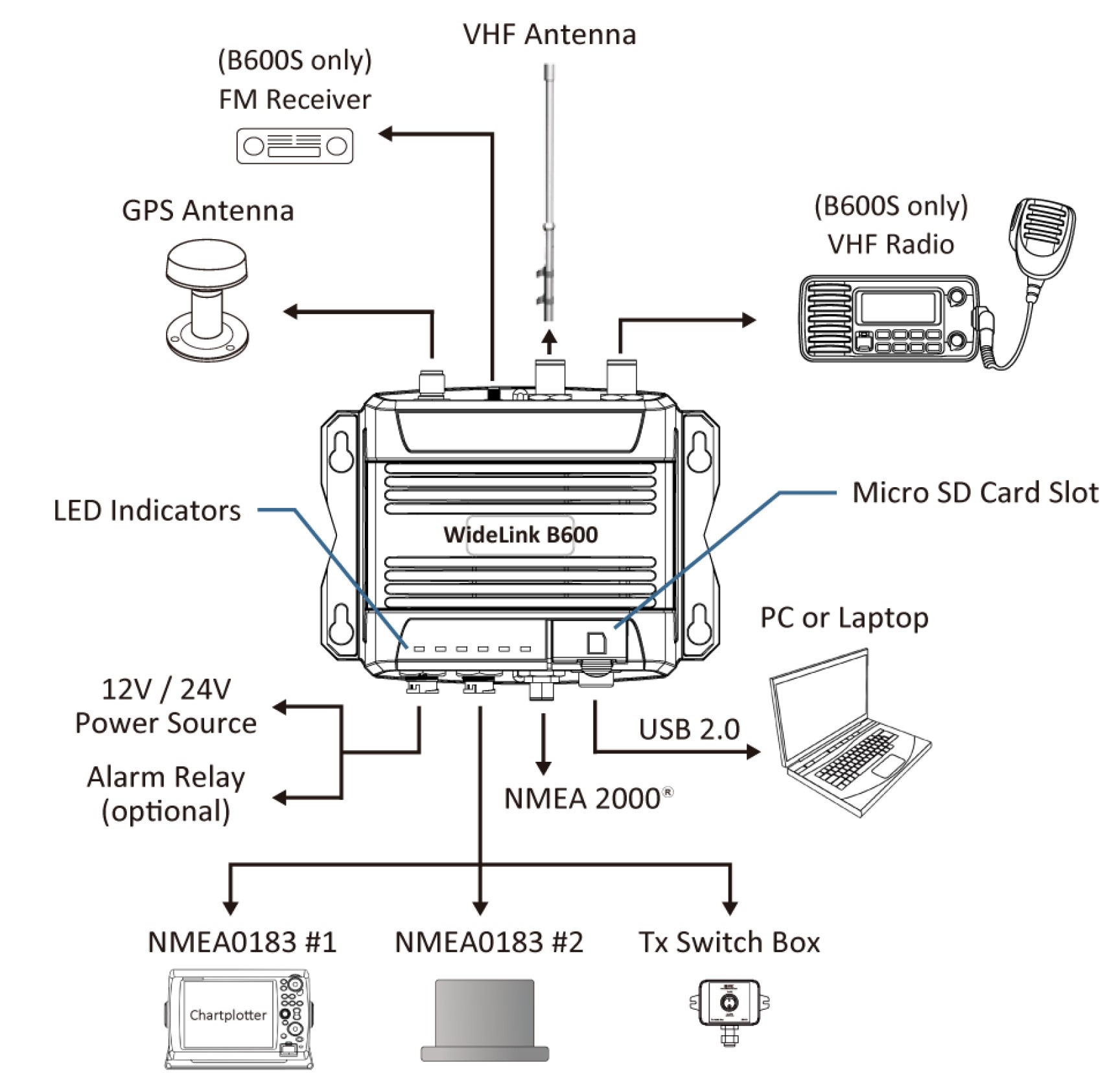

AMEC also makes a WideLink B600S model which contains an active antenna splitter so that the AIS can share a single antenna with a fixed VHF radio, as shown in the diagram. But if you want a Class B SO with a splitter and WiFi, one choice is the Em-Trak B954. In fact, the eight models of the Em-Trak B9xx series offer every possible combination of CS, SO, WiFi and splitter (though not the data multiplexing I’ll get to below).
At any rate, the WideLink system diagram suggests the several wired ways that AIS information can get to chartplotters and laptops (and not shown is the wireless connection to smartphones and tablets). But the reality on many boats is much simpler. On Junior, for instance, the B600W install only took the power cable and GPS antenna shown as there were already VHF and N2K cables in place from my install of a Si-Tex MDA-5, which had worked fine and is another Class B SO model that offers both WiFi and an antenna splitter. (Description of Junior’s electronics makeover here.)

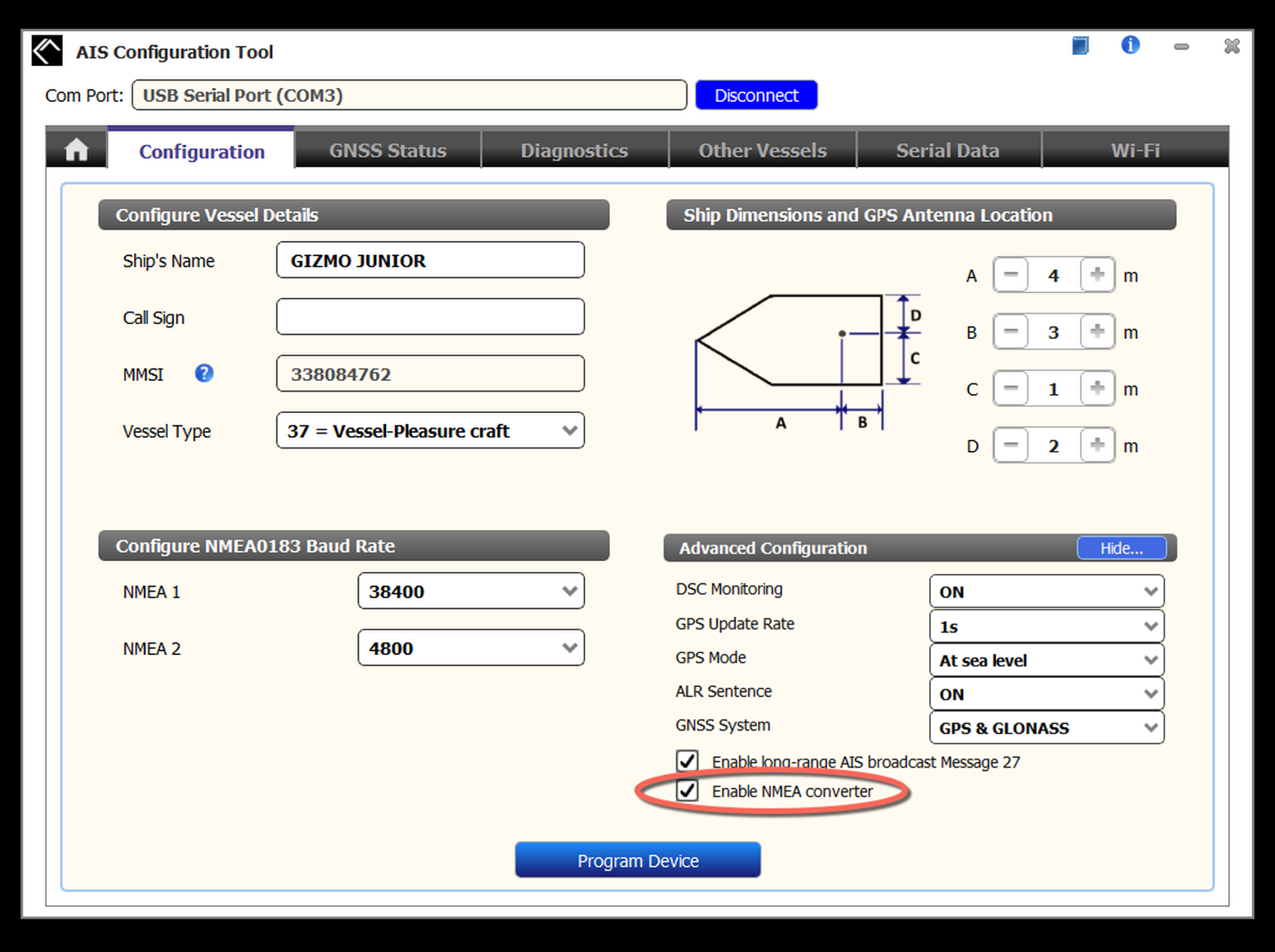
In the USA, a Class B AIS can only be programmed with an MMSI by a pro installer or a distributor like Milltech (their informative online form here). But a boat owner may want to use the configuration software for tasks other than MMSI entry, and I found that the Amec Windows program worked fine with my laptop connected by USB cable to the transceiver. (There’s also a Mac version of the config software, but no configuration or firmware updates by WiFi, as Vesper has offered for several years).
The screen seen above left shows how I set up the B600W’s WiFi access point. No password seemed needed with Junior’s simple electronics system, and the little boat also lacks its own WiFi system the B600W could have joined (though I like how Amec illustrates the difference). Also shown is the default IP address (192.168.2.1) and port number (3333) that most nav apps will need to find the transceiver’s stream of AIS and boat data (which are also in the manual). But you’re not going to get boat data like Depth, Heading, and Wind unless that righthand main configuration page is set up correctly.
Amec barely mentions that “Enable NMEA converter” software switch in the B600W manual, it’s unchecked by default, and that whole “Advanced Configuration” section is hidden by default! But Milltech clarifies the situation in its how-to about getting the B600W WiFi data to work with the Navionics app, and that app is a particularly good example of how useful “converted” boat data can be. Assuming that Depth is on your boat’s NMEA 2000 network, Navionics Boating connected to WideLink B600W WiFi will not just show water depth — as well as the transceiver’s accurate GNSS position and AIS targets — but collect the depth data for Navionics’ community SonarChart system.
It’s slick to have a mobile nav app fully accessorized with boat sensor data, and the technique Amec uses works with many apps. But I also think that the feature confuses many boaters and is worth a closer look.
So, above is part of the “NMEA Translations and Multiplexing” list found in the B600/B600W manual available in the Downloads section of the Amec product web page. It’s organized by NMEA 2000 PGNs (Parameter Group Numbers), primarily the GPS and AIS message groups that the transceiver sends out on the boat’s N2K network. But note that several unrelated PGNs like Water Depth (#128267) are received by a B600W and then translated to NMEA 0183. That’s the confusing part.
There is no official protocol for networking NMEA 2000 PGNs over Ethernet and WiFi (or USB) — though it’s still a promised feature of NMEA OneNet — but an informal method has been adopted by many developers. The technique is to convert the data in a PGN like Depth into the equivalent NMEA 0183 data message, which is plain text and thus more easily pushed over a different network scheme like Ethernet/WiFi and also more easily handled by a nav app.
In short, the N2K Depth PGN is translated into the 0183 DPT message and then multiplexed with the 0183 AIS and GPS messages already being created by the B600W, and it’s all sent out over WiFi and USB. The same data mix also goes out on the transceiver’s NMEA 0183 ports, which can used with a gadget like FloatHub for offboat monitoring and trip logging.
Besides the translations shown above, the rest of the list includes Wind and several other weather data points like Barometric Pressure. But, remember, the boat sensor info won’t get translated and multiplexed unless you or the installer has set up NMEA conversion in Amec’s configuration program.

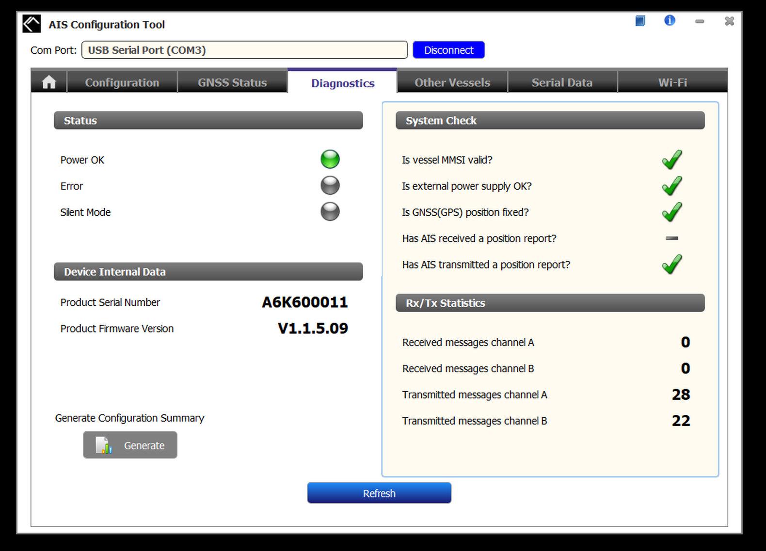
Speaking of the configuration tool, I also used it to confirm that the B600W was working properly in my shop before the install on Junior. And by the same token, it can be used to check out an Amec transceiver that doesn’t seem to be acting right. The Serial Data tab even shows the NMEA 0183 sentences streaming out the various ports, translations included.
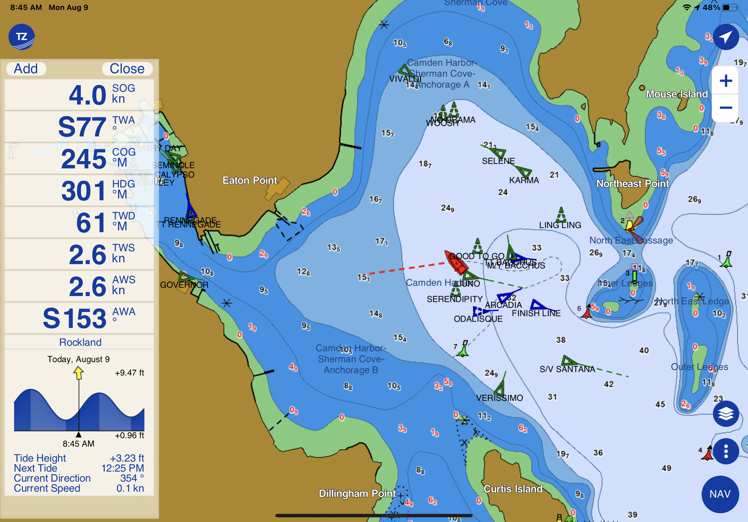
Now here is Amec’s translations and multiplexing feature seen in action on my iPad. It’s logged onto the B600W’s WiFi access point and I’d initially set up TimeZero iBoat with the data stream’s IP address and Port number (which it remembers). Junior doesn’t have Depth on its NMEA 2000 network, and its Heading sensor was messed up at this juncture, but I think it’s clear how a rich stream of boat data can make a mobile nav app more like a dedicated multifunction display.
To my knowledge, the only other Class B AIS transceivers able to multiplex other boat info into their WiFi and other outputs are made by Vesper Marine (and the mentioned FloatHub is fed by a long-tested Vesper XB-8000). I obviously like the feature, but there are other ways to skin the cat. For instance, companies like Actisense, Digital Yacht, and Yacht Devices make NMEA 2000 powered WiFi devices that can do the same data translations for wireless nav apps. And, to be clear, every Class B with WiFi outputs GPS and AIS info, just not the extra data from an attached N2K network.
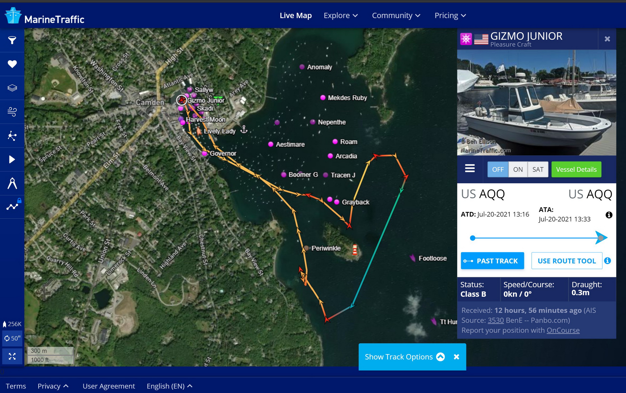
Overall, I rate the Amec WideLink B600W a solid contender in the Class B market, and especially valuable for those trying to get the most out of mobile or PC navigation apps. Plus, I think it’s only slightly ridiculous to have AIS on a 20-foot boat. That track roughly shows Junior and I tending my five lobster traps in Camden Outer Harbor, and there’s often a lot of traffic, sometimes masked by the moored boats, or fog. Of course I try to keep a good eye out as I maneuver about, but don’t you agree that Junior’s AIS presence adds a safety edge?


Will this allow the use of a GPS antenna over NMEA 2000, or does it require a dedicated GPS antenna?
Hi Roger, All Class B AIS transceivers are required by regulation to have their own GNSS (GPS) receiver. So what you’re asking for is not possible. However, AIS units like this one typically output GNSS position/SoG/CoG info over NMEA 2000, WiFi, and USB. You can see the PGNs in the table above as well as some configuration options like GPS update rate.
thanks for the quick reply. Looks like there will be GPS antennas all over the boat, One built into chart plotter, one for autopilot, and one for AIS
Messages from an AIS receiver can easily overload an NMEA2000 network and choke the communication for all other units connected to the NMEA2000. Using NMEA0183 HS will ease the tension on the NMEA2000 network and the AIS will have a dedicated connection to the MFD.
The NMEA0183 connection is also recommended by for example True Heading, instead of using NMEA2000
An old protocol isn’t always bad
In my little sailing vessel I have a True Heading AIS class B since 10 years back and it works flawlessly, despite new MFD from time to time. One summer I also tested Vesper Marine XB 8000 and found it full of good things, especially it’s ability to connect to WiFi, both as a host and connected to a WiFI router. The nice thing with the latter is that I’m not limited to connect my cell phone / laptop to only one item, I can connect to all units that are connected to the WiFi router. Not all equipment offers this, I haven’t seen it on Garmin MFD for example.
Another very useful function with the Vesper XB 8000 is that it has a standing-wave-ratio meter built in. With this I can check how good my VHS antenna works.
I haven’t had the opportunity to test the Vesper Cortex, but with all those functions it will come with another price tag.
Paliswe, where did you get the idea that AIS can overload NMEA 2000? I’ve never heard of that happening to anyone and certainly never seen it on my own boat.
Paliswe, good to know… first I heard about AIS swamping out N2000….but does anybody even make a N0183 HS heading sensor anymore? And if other devices on the N2000 network that need GPS data (such as autopilot) be able to use it if it were on N0183 HS?
Paliswe, good to know… first I heard about AIS swamping out N2000….but does anybody even make a N0183 HS heading sensor anymore? And if other devices on the N2000 network that need GPS data (such as autopilot) be able to use it if it were on N0183 HS?
@Roger GPS data is routed to the MFD and then the Autopilot gets all the information from there.
I use the position from the MFD (Garmin 7410) and not the position data from the AIS for navigation but the MFD can be set to use the position data from the AIS instead of using internal GPS data. This because the GPS in the MFD is newer than the one in my old True Heading, with a faster update rate.
Vesper XB 8000 has a NMEA 0183 connection. This can be used to route info from the NMEA2000 network to devices that do not have NMEA2000. I used it for sending AIS info to my MFD.
It was said to me by a guy on True Heading. Maybe it was because True Heading at that time didn’t have NMEA2000 on their AIS, I don’t know. Perhaps it’s time to reconsider this opinion.
I’d suggest it probably is time to reconsider this opinion. I’ve also never heard of AIS swamping N2K nor have I experienced it, including in some of the nation’s busiest ports.
-Ben S.
I’ve been thinking about the assertion that AIS might overwhelm a NMEA 2000 network. I’m not sure why it took me quite so long to connect the dots, but they finally connected. It’s simply not possible. Let’s take a quick look at how AIS works. (https://www.navcen.uscg.gov/?pageName=AISworks) There are two AIS frequencies and AIS transceivers use both of these frequencies. Transmissions are made using FM modulation at 9,600 bits per second. In reality, the same message is broadcast on both frequencies to avoid interference and congestion from disrupting transmissions. But, even if we assume both frequencies are available for separate transmissions there’s only 19,200 bits per second of throughput over the VHF transmission mechanism for AIS.
NMEA 2000 networks run at 256 kbs or 262,144 bits per second. As you can see, there’s simply no chance AIS will overrun N2K. Even if encoding the data into NMEA 2000 PGNs added overhead there’s no chance it would be greater than 10x.
-Ben S.
I have installed a B600S last year and I have been happy with it during the first season. The only downside I found was that the USB port should not be used for operation but for programming only as it is not properly isolated (like it was on my true heading AIS receiver!) but this can be overcome by using one of the two nmea0183 ports (if not the N2K port).
During last winter I realized that the multiplexing capability of the unit is somewhat limited: I tried to use the slow NMEA port of the unit to feed an NMEA 0183 capable listener (a display) to show the GPS position data. Surprisingly this did not work well, simply as the nmea port of the display to be used got clogged up by the data feed from the B600S. Proper analysis showed that the B600S sends its complete stream of data including the phrases for AIS (VDM/VDO) data as well over the slow port which of course no regular nmea0183 port can handle. I checked this with AMEC and they confirmed my analysis.
So the multiplexing capabilityof the B600 series is somewhat limited. As it cannot filter any data (not even its own) out this makes the slow NMEA port useless for outputting data.
A workaround could be to output the data over the high speed port and utilize a proper multiplexer to adapt the data stream with respect to content and speed to make it fit to any listener. and of course this will not pose a problem using N2K.
Thanks very much for the insight, very useful as I was intending to (temporarily, until I build a proper multiplexer) use the B600S USB output to feed NMEA2k data into a Raspberry Pi.
Right, the USB port shouldn’t be used continuously. This stated in the manual of the device but not in a prominent way (which it should as it may impair the integrity of the vessel for a leak of galvanic isolation). But t is could certainly circumvented by either using the 0183HS or N2K port for feed o a dedicated multiplexer.