
PredictWind introduces Over the Horizon AIS, a world-first
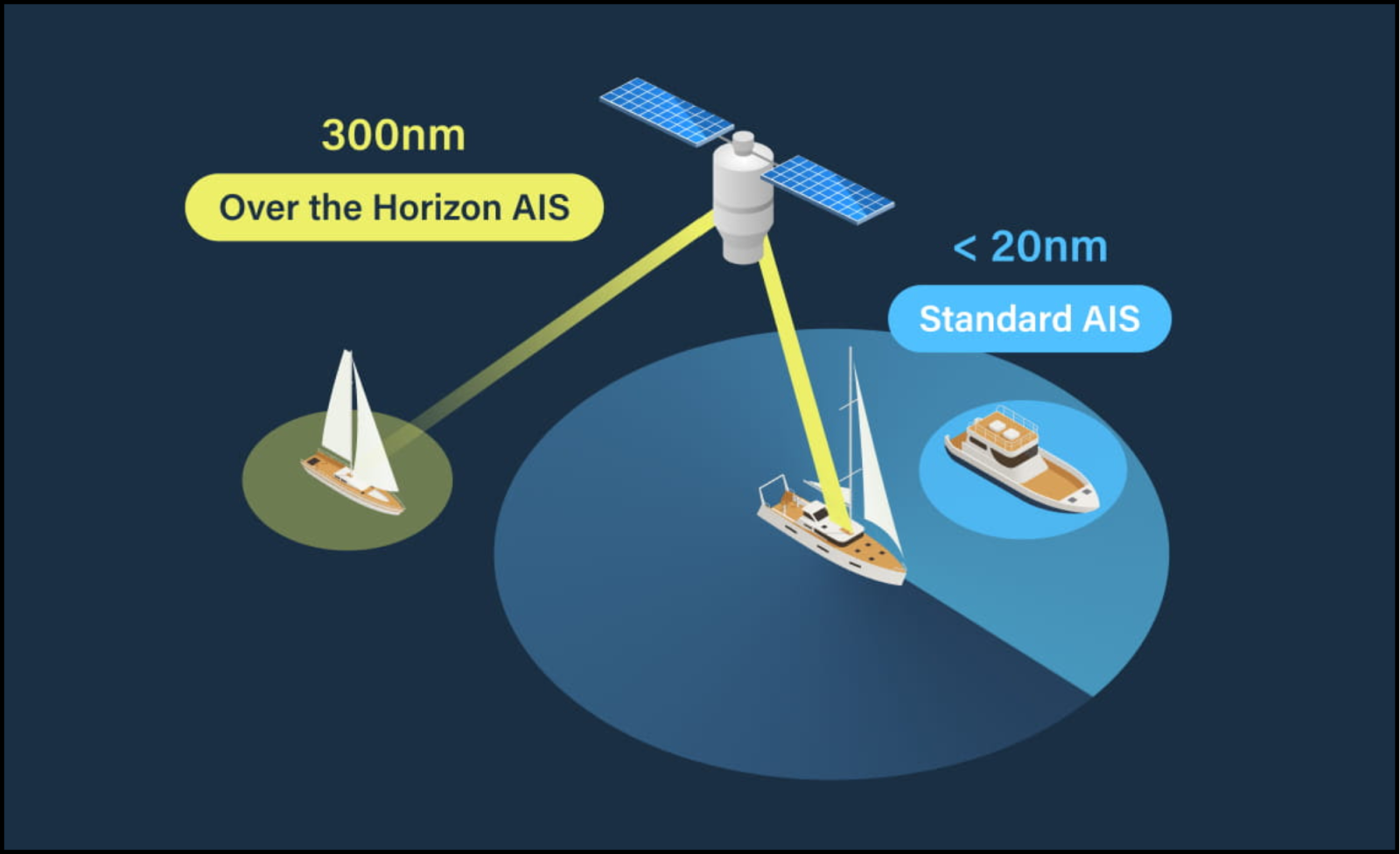
We are excited to release the all new Over the Horizon AIS (OHA) feature on the DataHub. View AIS data out to 300nm, directly on your chart-plotter and nav apps, so you can sail safer.
Over the Horizon AIS (OHA) increases your AIS range from as low as 5nm to 300nm! If you are sailing at 10 kt using regular AIS and a container ship is sailing directly towards you at 25 kt, you only have 8.5 minutes to react and alter course. On the other hand, OHA would provide you with 8.5 hours warning time.
(Some chart plotters cannot display the full 300nm AIS range. For example, Garmin cuts off at 75nm.)
Powered by the DataHub
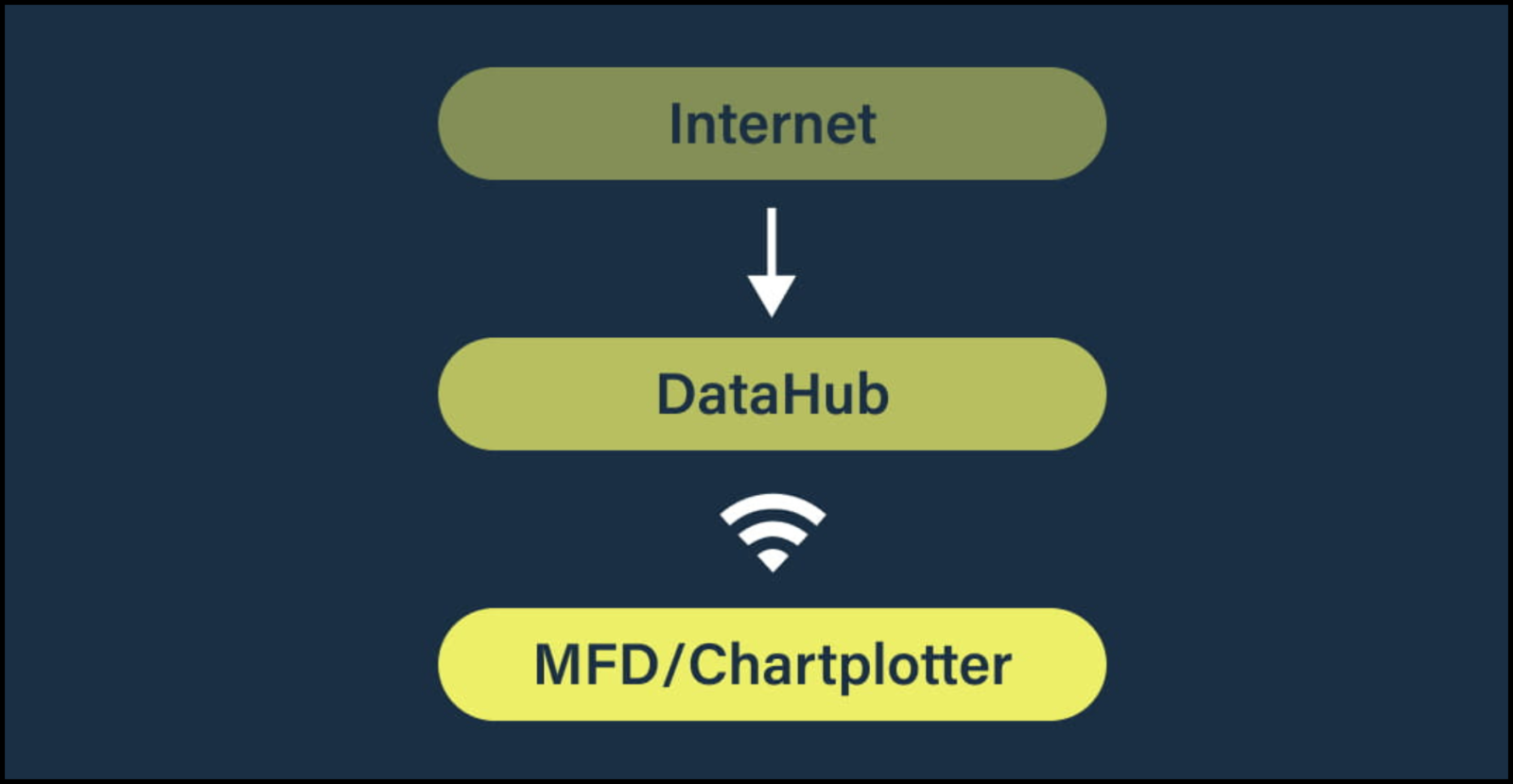
The PredictWind DataHub has access to the entire global AIS network via your existing internet connection and knows your exact GPS location. It then downloads all OHA vessel positions within 300 nm of your current location.
The DataHub downloads the OHA data approximately once every minute. It is then converted into NMEA and shared to your vessel’s instrumentation over WiFi.
OHA targets are displayed on your nav display in the same way as regular AIS targets. When a vessel is located via VHF and OHA, only the VHF data will be displayed.
OHA data can be downloaded via your existing satellite or cellular internet connection.
Redundancy
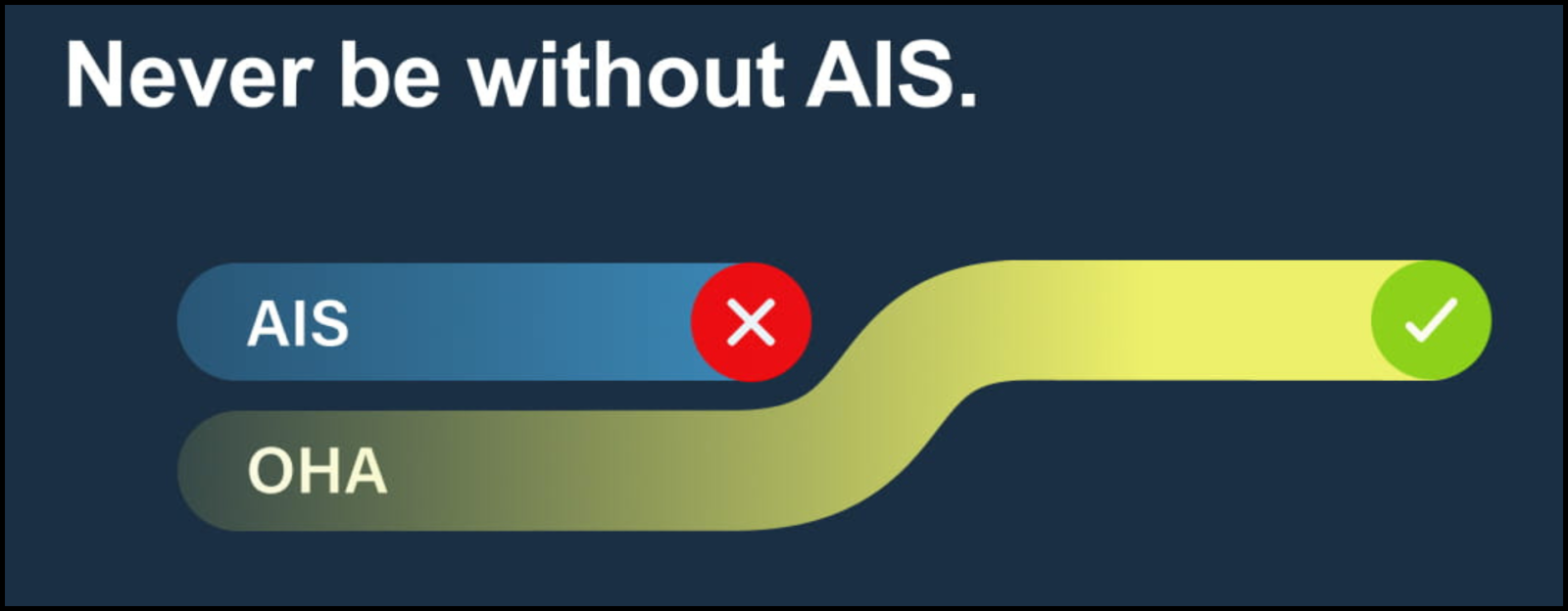
OHA also works as a backup should your standard AIS receiver fail. Ensure you are never without AIS data, which is critical for collision avoidance, security, navigational safety and search and rescue.
To get Over the Horizon AIS working on your boat you will need a DataHub and a Professional PredictWind subscription.
Get 300nm AIS visibility now: Buy DataHub $299 — — Upgrade to Pro
Also at PredictWind: Full OHA news blog — — OHA help page
Related Posts:


Panbo publishes select press releases as a service to readers and the marine electronics industry. The release contents do not reflect the opinion of the editors and are not fact checked by the editors


Readers may recall that longtime Panbo friend Luis Soltero helps develop the DataHub, and that it can already neatly share a boat’s AIS info with other boats and the cloud:
https://panbo.com/share-your-boats-ais-info-easy-with-datahub-by-predictwind/
At any rate, Luis told me about this new OHA feature a while back and although I’ve long been leery about using internet AIS info for collision avoidance, this unique integration looks well thought out. For instance, the data coming from ashore can be tagged as such by putting “DataHub” in the target vessel Call Sign field, or even shown graphically if the target display app cooperates (as AquaMap already has, I think).
And by the way, the OHA target range is adjustable, with 25 nm the default (as also explained on the OHA help page).
Finally, here’s me getting some real help from internet AIS (on a separate screen) while solo offshore:
https://panbo.com/standing-a-24-hour-watch-am-i-nuts/
Hello All,
A while back I created a YouTube video that describes setup and use of Over the Horizon AIS (OHA) on DataHub. Here is the link
https://youtu.be/Rf26kTZqlL0
The video explains numbers different setup scenarios and explains setup options in DataHub.
–Luis
” If you are sailing at 10 kt using regular AIS and a container ship is sailing directly towards you at 25 kt, you only have 8.5 minutes to react and alter course. ”
This line assumes your AIS is picking up the 1st signal from a container ship at 5 NM. Really? Even if that was the case, 8.5 minutes is plenty of time to make a course or speed change. Seems like a silly product.
It’s a great feature, I use something similar with TimeZero – it pulls MarineTraffic and shows those targets as a different color. This works well in areas where there are enough AIS ground stations but terrain can obscure features. I can see buddy boats and friends from some distance off without having to pull up an app on my phone, and it seems to help targets load as a name with the first position report vs coming up as an MMSI and having to wait for their static data (6 min interval) to send to get dimensions/name/etc…
As Ben mentions above in https://panbo.com/standing-a-24-hour-watch-am-i-nuts/ having access long range targets is useful if you are single handed since it provides confidence when offshore taking longer rest breaks, for example. Not sure about you but I can certainly see spending 8.5 minutes in the head!
This reminds me of a scene in the movie pink lady where Jessica Watson is a sleep offshore and gets rammed by a large ship. Over the Horizon AIS would have allowed her to know about the vessel and taken action before she laid down to rest.
Anyway, in our business the more redundancy the better… so why not? I mean, I carry a sextant, a time piece, and lunar method tables on my boat but also use a modern GPS and chart plotter. I could say.. why use a GPS when a sextant works fine. but….
One big difference between TimeZero and DataHub’s implementation is that with your PW account you have access to the entire universe of AIS targets whether they originate from Satellite, Terrestrial, or Mobile AIS stations. Although not familiar with TZ I suspect you might get those from MarineTraffic if you purchase a high end subscription that provides satellite data. Typically these are quite expensive.
The Satellite piece – while in the pictures, didn’t come out quite clear. That is a huge boon. I only seem to see those in range of terrestrial stations. This would theoretically let me see into places like fjords before going in…
So trying this out and one pretty dangerous thing I’m observing. Datahub seems to overwrite the “time” part of the messages it passes which make old fixes look new. With TZPro and MarineTraffic, the MarineTraffic data seems to have better coverage, but enough of a delay that the DataHub takes precedence. As a result – DataHub shows a boat in harbor (wrong/old), Marine Traffic shows it maneuvering in a channel (correct). TZPro seems to then run with the DataHub data since it has a current time (seeing <1 min since last fix). Disable data hub and the boat shows in the right place with MarineTraffic. So my guess is either Datahub is overwriting that part of the sentence or TZ Pro isn't honoring that part?
Probably not an issue if your only source is Datahub or local AIS receiver, but among the three I'd like the time from the actual AIS frames going out vs when received to be priority.
please watch this video
https://www.youtube.com/watch?v=Rf26kTZqlL0
it explains everything you need to know about OHA.
AIS is assumed to be realtime…. So.. navapps compute the age of the AIS targets based on the time of acquisition. This obviously does not work for OHA which by definition is aged.
So.. DH takes some steps help you identify these targets and if it can actually provide the time of acquisition.
The video goes over these. But here is a summary
1. All OHA targets are tagged with call sign DATAHUB. If the call sign is something other than DATAHUB then the target was acquired over the air.
2. All NMEA183 AIS sentences are tagged with the time of the acquisition. Unfortunately very few apps support NMEA4.X tags. AquaMap is an exception. AquaMap will extract the acquisition date from the NMEA tags and display the age correctly for these targets.
3. Class A targets have the Destination field changed to “TIME OF LAST UPDATE” and the ETA is set to the Time of acquisition. Unfortunately Class B targets do not provide a way to encode a time/date for acquisition.
Latencies for terrestrially acquired targets range in the 1-5 minute range. Those for Satellite can be as long as 30 minutes.
Anyone using this product should be aware of the above… You might consider switching to AquaMap if you use the feature since, gain, the age of all targets is computed and displayed correctly.
Take care.
–Luis
Also note that over the air AIS targets take precedence over OHA targets. But… keep in mind that AIS transmitters can have long delays between transmissions. A class B transmitter at anchor might update once every 10 minutes, for example. When you first turn on your equipment DataHub will download and transmit OHA immediately. These will be displayed on NAV apps even though OAA targets might be available. This is because DH has not seen the OAA targets and therefore can’t filter out the OHA collisions. Once DH received an OAA target it will no longer push out the OHA version of the same target. So.. after 10 minutes or so OAA targets will be displayed if in range and only those targets in the distance will be OHA.
Also note that PW gets its data from Spire which which supplies both terrestrial and satellite AIS data. The DATAHUB on average (for shorter distances) pulls data from Spire once a minute…. However, if you set the range to 300 miles and you are coastal this could be many thousands of vessels. Under these conditions the updates are slowed so as to not overwhelm the N2K network and the nav apps. for 5000 targets the updates take place about every 10 minutes.
syslog in DH will display the frequency of updates and then number of AIS targets downloaded from spire.
–Luis
So 0183 has the time of acquisition but N2K PGNs do not?
Yes. But only for applications that can interpret nmea v4.0 tags. The age timestamp is not encoded in the AIS sentences. The AIS standard definition has no field for age since AIS reception is done in real time. The age is added to an external nmea tag which is defined in the nmea 4.0 extension but is not part of the AIS specs. So only nav apps that can interpret the nmea tags will display the age of the OHA targets correctly. As fas as I know AquaMap is the only app that currently does this.
Note that for class A targets in both nmea2000 and nmea183 formats, the eta field is modified to time of target acquisition. The destination field is set to “TIME OF LAST UPDATE”. Class B AIS does not support the eta field so there is no tay to tag these with a timestamp.
Hi Sven, I too have been confused about OHA time issues, mainly because I thought that all AIS messages included a transmission timestamp. And indeed they do, BUT now I realize they are only 6 bits long and only stamp “UTC second when the report was generated by the EPFS (0-59)”: https://www.navcen.uscg.gov/ais-class-b-reports
So that’s a problem when there is latency between the AIS receiver and the device displaying targets. I assume that MT and similar get around this by applying a full time-of-acquisition stamp at the receiver end which is understood by any display software programmed for MT data. But OHA uniquely mixes offboat data with what streams from the vessel’s own AIS receiver, which is why Luis incorporated multiple ways to add a more verbose timestamp or at least mark or deprioritize OHA targets. On the other hand, Spire claims pretty low latency for even their Standard service: https://spire.com/maritime/solutions/standard-ais/
I trust that Luis will speak up if I’ve made mistakes above, which is quite possible 😉 But I do quibble with his “A class B transmitter at anchor might update once every 10 minutes”. When anchored or going very slow, both Class A and B transmit position messages every 3 minutes: https://www.navcen.uscg.gov/sites/default/files/pdf/AIS_Comparison_By_Class.pdf
OK! you are correct… it just feels like 10minutes when you are sitting there waiting for the targets to come in 🙂
Hopefully the AIS standard will be extended to include a higher precision time stamp at some point. As internet on vessels becomes more common place AIS over internet will become more pervasive. Currently seconds in the current hour is not sufficient to nail down the time of a target.
Although we find that OHA for moving vessels are usually less than 5 minutes old the issue is that internet targets persist even after their AIS transmitters are turned off. So.. position reports could be days, months, or even years old. So it’s important to filter these out. DH, by default, will not display anything older than 45 minutes. This can be adjusted in the UI.
Even with all these limitations the service is super for long range situation awareness. I just got news from a friend that Is using it to gauge how busy anchorages are in the Bahamas before they depart their current anchorage. It helps then select destinations that are not as crowded.
–Luis
Luis,
As I’ve read this thread I’ve vacillated back and forth with concerns that the complexities of implementation could outweigh the benefit. Thinking it through, I wonder if utilizing one of the infrequently used vessel types (like wing-in-ground or something else obscure) might help. Not all MFDs display different icons for different vessel types, but some do. That alone would be huge. I’d love to see over the horizon targets represented differently than those received by the boat’s AIS transceiver.
-Ben S.
That is a really good idea… Let me look into that.
There has been discussions about using OHA to display other kinds of data such as virtual ATON, whales, restricted regions, MOB, DSC alarms, etc…
I will investigate to see what might be practical.
–Luis