
Tim Thurston, map maker extraordinaire
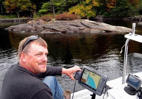
Tim Thurston earned that grin. We were out on Lake Megunticook randomly comparing the digital map I helped Navionics make last fall with the survey work Tim did for his little Maine Lake Charts company at about the same time. And while that little islet in the background is on the beautiful MLC paper map Tim made, and on that Garmin Etrex he managed to put his digital data on, it was completely missing from the Navionics map! While this is a shallow and somewhat out-of-the-way spot I steered us to — and both maps are way, way better than what was available until to this summer — I tend to think that Tim got the details better. Unfortunately boaters can’t make best use of those details just yet…
The problem is that Tim hasn’t yet found a way to license his data with one or more of the big digital map providers. What he has to offer may be very carefully collected and checked, but it just represents a couple dozen lakes in a small market, and meanwhile Navionics, Garmin, C-Map, and Navico are trying to collect as many lakes as possible so they can offer the largest coverage, which often is nearly given away on preloaded MFDs. Here’s hoping that the march of technology makes it possible for a small but passionate cartography operation like MLC to make its data available in all sorts of digital formats. Some boaters will be willing to pay even a premium price for the quality seen in the following images.
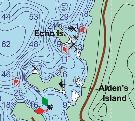
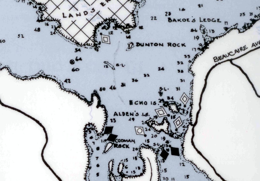
Below is a small section from MLC’s 12- by 18-inch printed Megunticook map. The little islet seen in the photo above is between Alden’s Island and the mainland. While this section is only 1.5″ wide as printed, it’s drawn well enough to make out fairly well. But it still doesn’t represent all the detail Tim collected. In fact, when we meandered amongst those rocks inside Echo Island, they seem to be plotted accurately on Tim’s zoomed in Etrex.
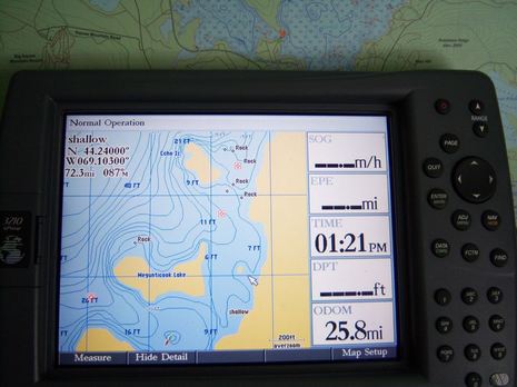
 Had we had the MLC data on a big Garmin like below (which Tim photographed after the fact), maybe we wouldn’t have, um, “tapped” one of those rocks with Li’l Gizmo’s bows (admittedly we could have been looking ahead better too).
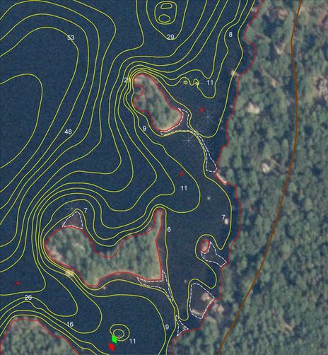
 Finally, below is a view of MLC data overlaid on the latest public domain photo maps, which is one technique Tim uses to double check the available shore line data and catch anomalies like the islet. Thurston, incidentally, works days for the Maine Dept. of Conservation managing aids to navigation on some of state’s lakes, but he learned about bottom surveying, GIS software, map design, printing, etc. all on his own, and he handles every step in a map’s creation in his spare time. Darn impressive, right?
Now I’m looking for signs that Tim’s work, and that of similar small map makers, can make it to our plotters and PCs. One is Mapwel, the program Thurston used to get his data into Garmin format, and another is the way Garmin’s recently opened some of its handhelds to homemade raster maps. Plus there’s X-Traverse, which facilitates an efficient connection between even a small digital chart provider and the end user. None of these is the answer, but is there a trend that will make map data easier to distribute?


Ben:
Consider the liability issue of Garmin or others relying on dozens, maybe hundreds of cottage industry cartographers. How do they insure quality?
David
I wouldn’t necessarily say this is the case.
There are ways of loading custom data onto units. Consider GPSMapEdit and LCMMapEdit. Neither were provided by the company that is getting the maps loaded onto their units. Both suffer from a lack of customization and don’t quite work right. Global Mapper has incorporated the LCMMapEdit dll into their version 11 software and replaced the UI. There are several companies and people that are using variations of these programs to distribute their maps onto units.
Garmin has a method of loading rasterized custom maps onto their outdoors units.
There are other cases where the unit company works with the mapping company (Navionics and LakeMaster). In these cases, these maps are included on separate cards and not integrated into the company’s maps.
There has been a recent shift and there is a definite market for custom maps (as can be seen by Hummingbird’s and Garmin’s recent adoption of LakeMaster maps).
This is one of those problems that is working itself out.
I forgot to mention DrDepth, which lets a user create bathy maps and use them on a Lowrance plotter:
http://www.drdepth.se/index.php?l=gb
Per Pelin has even successfully used his mapping with Minnkotta’s new trolling motor autopilot:
http://www.drdepth.se/rdtwo.php?l=gb
David, don’t all these digital maps come with extensive disclaimers? And shouldn’t we all be skeptical of all map/chart detail anyway?
Looks very impressive. Ireland has been blessed with many interconnected large inland lakes on the rivers Shannon and Erne which are used by large cruisers and all manner of leisure craft. Independent digital map makers have produced Garmin charts that run on the old gear (ie 2xxx, 3xxx, 276, 76, 60 series plotters), but they can not find a way to get the charts running on the newer Garmin G2 Vision compatible plotters as the format has changed and Garmin seem to want to keep it closed. Does anybody know of a tool that can be used to compile charts in the format used by the 4xxx, 5xxxm, 4xx or 5xx series?
http://www.shannoncharts.com
Lough Ree has full depth info on the above.
Fugawi, which I use, and probably most other PC nav programs allow importing custom maps. so there should not be a problem.
Looks like good stuff — as an old mapmaker I can appreciate it.
Michael Porter
Ben:
You wrote: “David, don’t all these digital maps come with extensive disclaimers? And shouldn’t we all be skeptical of all map/chart detail anyway?”
Well, yes but….
US coastal charts are all based on NOAA data. I would submit that Garmin, Navionics, etc. have a serious liability problem if an error in their translation of NOAA data causes an accident regardless of disclaimers. So far I am not aware of any such accidents. I cruised the entire East Coast this year with a Raymarine chartplotter with Navionics cartography and I never saw a single feature off more than 50 feet.
The inland data is a different story. There is no NOAA. There may be US Corps of Engineers or similar for some inland waterways, but small lakes in Maine, nope only private data and so it is 100% the cartography company’s product. When I buy Navionics data I expect it to be right however they may have acquired it.
I suspect that the large cartography companies are very concerned about accuracy and therefore liability irrespective of disclaimers. It will be an interesting phenomenon to watch now that private data is being used.
But I agree that the best course would be to have an easy way to import “foreign” data into your Garmin, etc. Then the liability issue is between you and whoever supplied the data.
David
David,
I think Garmin is having problems insuring quality without the help of “cottage industry cartographers” as evidenced by their recent G2 chart recall. Seems they have trouble repackaging freely available information from the NOAA.
Diversity of information is something I like on my charts, and the closed system of many chartplotters is why my boat uses a ruggedized PC with navigation software that is infinitely more flexible than any chartplotter out there (as well as less expensive). I’m one of many I know who uses such a setup and a growing trend I hear in discussions with others contemplating new equipment.
The less flexible companies make their product, the more likely customers are going to go elsewhere to meet their needs.
Dan
C-Map and others already take in data from 3rd parties such as harbour authorities etc. The issue is not so much the source of the data, more making sure that it is surveyed to adequate standards – the IHO have a range of survey accuracy standards.
Many PC chart plotters will accept data in open standards such as S-57 or GeoTIFF.
We are just about to start a research project in Europe on using logged depth and position data to input into charts. Only 2 European countries say that their coastal waters are adequately surveyed, and even those such as the UK who are acknowledged leaders say only 50% is properly surveyed. Some say only 10%. More on this in the new year…
Tim Thornton
Smartcom Software
What Tim is doing is admirable and there certainly is a place in the marketplace for his product.
Back in the day, the commercially available charts for the Bahamas ranked from abysmal to dangerous, depending on what you hit!!! We depended on “seaman’s eye” to read the water. Along came Steve Dodge in the Abacos with a small boat, GPS and fathometer/fishfinder. An instant cartography vessel. He zigzagged across the “tin” water of the Abacos, checked his data against government land survey charts to get good reference points, and produced a cruising guide that is still used today.
Steve Pavlidis followed suit with the same type of cartography vessel in the Exumas and the Turks and Caicos.
The Explorer Charts followed. And so it went. With each improvement in GPS (DGPS, WAAS) and the fathometer/fishfinder equipment, the charts got better.
It is a logical step to move this digitized data to today’s chartplotter via USB drive, card, or Bluetooth.
Good luck in your endeavor, Tim.
Life is good.
Seems like a good opportunity to follow suit with the rest of the Internet startups and create mapping communities. There’s a project right now where the Internet was scoured for hundreds of thousands of pictures of Rome (I believe it was Rome, but it WAS an Italian city). These pictures were then matched together and a complete, high resolution walkthrough of Rome was created that far exceeded the quality of what Google has done with Streetview.
Bridge the gap, and allow hundreds of people to send in surveys of the Bahamas (for example). The cartography company does a QA check on the data by making sure that enough people have the same measurement of the same geographic location. This information is then used to create the next generation of charts. As more people get involved with doing the surveying, more “how-to” documents will be made available allowing people to understand what the process involves.
Now – expand this to the world, and we can map all of the individual lakes, remote countries, etc. What we need to do is to create mapping “communities” of boaters, and then get the cartography companies to accept the data and use it. Just sign me up for some stock of the first company that makes it happen.
Check out http://argus.survice.com/
We are in the process of developing an autonomous system that records depth data from vessels-of-opportunity (all of us), sends the data to a central server, and processes it to calculate depths. The system and processing currently provide accuracy sufficient to show where the charts are wrong, which is mainly what we all care about anyway. The initial R&D was funded by NOAA. We expect future advances in GPS, sonar, and processing to only improve the solution and approach IHO Order 1 standards.
John Hersey
SURVICE Engineering
Thanks, John! Note to readers: I learned about Argus at the NMEA convention and plan to write more soon. Very interesting project; check out the link!
Interesting: Garmin just issued new Inland Lakes U.S. coverage that now includes lots of new lakes in Maine and elsewhere, including Megunticook.
https://buy.garmin.com/shop/shop.do?pID=1404&pvID=2691
I suspect that means they’ve licensed data from Fishing Hot Spots, which bought all of Tim Thurston’s work last winter. So in just over a year, my local lake went from zero electronic charts to at least two surveys now available for most any brand of plotter and several planning/charting programs, not to mention iThings and Droids coming (thanks to Navionics). And I think that’s happening all over this country and others. Cool!