
C-Map is back, in many dimensions
Actually C-Map never went away. But it has been fairly quiet since becoming part of Jeppesen Marine in early 2007. Oh there was scuttlebutt about how Jeppesen resources meant vastly improved data acquisition and distribution capabilities, not to mention evidence of zero error tolerance. And C-Map MaxPro cartography came to Nobeltec charting, though sadly many remember the event more for a dumb raster chart policy than, say, MaxPro’s slick Quick Sync data updating. Meanwhile, arch rival Navionics worked its way into more and more displays. But things change, as certainly happened on Tuesday when Raymarine previewed E Wides, which will come C-Map preloaded and also support a new format C-Map calls 4D…
4D’s fourth dimension is time, a reference to a yet undetailed “constant” updating program that sounds a lot like MaxPro’s Quick Synch. But 4D goes the other way with rasters, letting an E-Wide join Furuno NN3D as the only current MFDs able to display, even 3D, official NOAA raster charts (I don’t think Faria’s Maestro ever shipped, to my embarrassment).
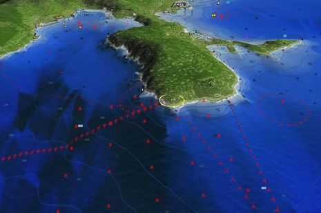
 I’m liking what I can see of 4D’s 3D abilities in these promotional screens, particularly the one below which seems almost unbelievable in terms of tight registration between hi res photo and chart detail. It also seems to include custom C-Marina data, a great idea that I keep hoping other cartography companies will adopt. Isn’t easier than ever for marinas to map their facilities accurately and pass the info to the chart companies?
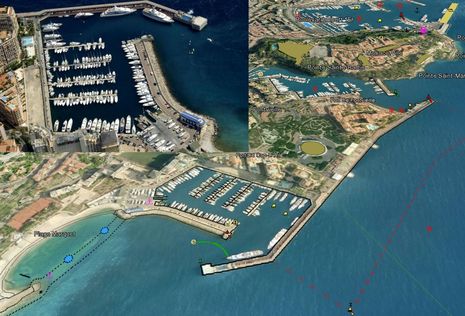
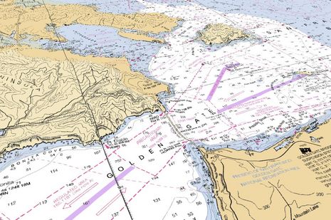
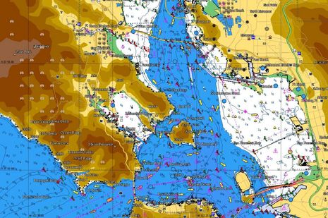
Of course 4D also has 2D vector charts, with or without terrain relief, live tides and currents, etc., as suggested below. And I hear, by the way, that 4D is not exclusive to Raymarine and may appear on other platforms eventually. But I’m looking forward to seeing it in action on an E Wide and am thinking that it’s time to take a close look at all the available chart formats. If I can ever finish the radar testing (swapping in two more radomes in the next few days!), all the attached displays (and PC) will make Gizmo quite the cartography test platform.


Ben Ellison
Panbo editor, publisher & chief bottlewasher from 4/2005 until 8/2018, and now pleased to have Ben Stein as a very able publisher, webmaster, and editing colleague. Please don't regard him as an "expert"; he's getting quite old and thinks that "fadiddling fumble-putz" is a more accurate description.
4 Responses
Join the conversation


It is exciting and at the very same time frightening to see how quickly technology has been bettered in just a short period of time. On the one hand, I am still upset at Raymarine for having dropped the RL-series, which “forced” me to upgrade to, in my case, the E-series. All of a sudden, my C-Map charts were worthless and ended-up on, where else, eBay. Now I am being hit over the head with E-wide and the fact, that it uses both, C-Map and Navionics. That is great news! At least, I can hold on to my $400 Navionics chip!
It seems Raymarine just can’t make some people happy…
I am truely excited that they have embraced serious technology! NN3D has been problematic to say the least. So for a company, some may feel, that has “one foot in the grave”, I say hats off to Raymarine and good luck!
The new RM units will display both types of cartography really well. Full colour, hi res and quality marine information on a bright screen with controls that don’t fail when lots of sea water is kicking around or the going gets rough….
The customer investment and practicalities are always uppermost in their minds. They listen (a lot) and are bringing some cracking new products to market in the next year.
Now Raymarin is not only platform to support 4D.
Italian Geonav seems to do that with their new G12 dual chartography MFD’s.
It works simulateously with Navionics Gold/Platinum on SD-cards and C-MAP 4D on???
Geonav claims this plotter will support “Easy Routing” from Jeppesen which should be something simular like autorouting we used to see in land GPS navigators. But C-MAP says not a word about this.