Category: Navigation

Garmin GMR 604 xHD, hand’s on 10

Garmin GMR 604 xHD, hand’s on

Garmin GMR406 Jonesport harbor cPanbo.JPG

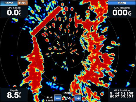
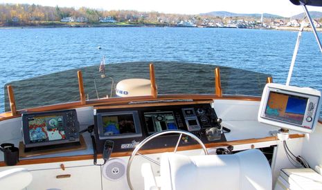
So that’s the Garmin GMR 604 xHD open array radar I installed last May painting a crowded harbor on the screen of a GPSMap 7212 in late July.  Gizmo was headed southwest at the time — the GPS heading, or COG, is meaningless because she’s tied up to a float — and so you have to twist your brain a bit to see how well the radar is imaging the details of Jonesport’s Sawyer Cove, and hence that the long straight target at the upper left is the famously uncharted steel and concrete breakwater there.  And I think if you make the comparison you’ll agree that the true color target display really helps to understand what the radar is doing.  Those light blue and green returns at upper left, for instance, are almost certainly some sort of noise created the breakwater’s heft and hardness.  I could have turned the gain down to eliminate that noise, but then I might not have seen the light blue at lower left — which is an emerging mud flat, I think — and similarly difficult targets once I got underway.  True color returns is indeed my favorite feature of the xHD/7212 combination…

Gizmo 2010-2011, Happy New Year! 23

Gizmo 2010-2011, Happy New Year!

Gizmo_fall_1010_cPanbo.JPG

I was happy to do some late season cruising and electronics testing on Gizmo this year, and am also happy that she’s snuggled high and dry under shrink wrap now that winter — including at least a foot of the white stuff — is really here.  But something I’m really excited about in 2011 is my plan to take the boat south next Fall.  Oh, I don’t intend to stop working; in fact, if the manufacturers continue to cooperate with what may be the industry’s longest testing program,  Gizmo’s flying bridge will look fairly similar to what I put together this season. (Which, come to think of it, I haven’t shown off until now; click above for a bigger image, and be assured that I have hundreds of screen shots yet to sort through and write about.)  A long gunkholing, blogging, and boat-show-ing circuit to, say, Charleston and back is sure motivating me, though…

Standard Horizon CPN Series, the first Internet MFDs? 36

Standard Horizon CPN Series, the first Internet MFDs?

Standard_Horizon_CPN1010i.JPG

At first glance Standard Horizon’s new CPN may look like a fairly standard multifunction display, but note the “turn page” screen graphic at lower right, the small (but purportedly powerful sounding) stereo speakers, and the “Multimedia Chart Plotter” designation.  The 7- and 10-inch CPNs have touch screens not only to help manage charting, optional radar, and so forth but also to select audio and video entertainment stored on front or back connected USB sources, or streaming over WiFi.  And, yes, there is a Web browser in there too!

Gizmo Thanksgiving, & the Garmin 740 networked 22

Gizmo Thanksgiving, & the Garmin 740 networked

Gizmo_lower_helm2_fall_2010_cPanbo.JPG

It’s about to be Thanksgiving here in the states, and — aside from the normal family stuff (which is huge) — I surely am thankful for being the custodian of a wonderful boat, for living in a beautiful corner of the oceans, and for getting to fool with some great technology.  Above is Gizmo’s lower helm, the Fall 2010 edition, and while there’s a lot here that I haven’t written about yet, I’m going to focus today on that little Garmin GPSMAP 740 on the chart table…

DAME Awards 2010, part 2 2

DAME Awards 2010, part 2

ODEO_laser_flare.JPG

DAME Awards will be chosen at METS this coming week for multiple categories, but there are electronical things well beyond the main marine electronics category discussed on Thursday.   Consider, for instance, how the ODEO Flare seen above attempts to replace pyrotechnics with four lasers and a revolving prism.  It does cost almost 100 pounds, but purportedly stays lit for 10 hours on 2 AA batteries, and it won’t burn you.  Also in the Lifesaving and Safety Equipment category are SeeTrac’s Jet-trak high-end PWC tracking system, McMurdo’s SmartFind S5 AIS SART, and Weatherdock’s easyRescue, which seems to be a personal-size AIS SART.  And of course there’s the Marine Related Software category…

Nobeltec VNS & Admiral 11, the preview 5

Nobeltec VNS & Admiral 11, the preview

Nobeltec_NavView_Fuel.JPG

Real time fuel range — as when it’s calculated using actual fuel flow and tank levels — is darn useful information; for instance, it should let you instantly see the effects of RPM or sea state changes not only on your MPG but also on your ability to get somewhere without a forced stop.  Which is why it’s neat that the Nobeltec 11 preview screen above shows the value as a number, as a circumference from your present position, and even as a distance along your active route.  And there’s an implication to this screen that I’m sure many of you will welcome (and may have already figured out)…

More on iPad as extra nav screen, from Nobeltec 11

More on iPad as extra nav screen, from Nobeltec

Nobeltec_Admiral_on_iPad_courtesy_Nobeltec.JPG

It’s not just the new edition of Coastal Explorer that can play nicely with an iPad.  In fact, it turns out that anyone running Nobeltec Admiral v6.5 or higher can get their iPad to show a variety of independent screens like the one above.  That’s because Admiral has long supported the extended desktop capabilities of Windows, as well as touch screens.  But Nobeltec Product Manager Bill Washburn, glimpsed in his own camera above, warns that screen refresh rate is marginal, at least at this point…

Coastal Explorer Express & 2011; hello subscription model 27

Coastal Explorer Express & 2011; hello subscription model

Coastal_Explorer_Express_cPanbo.JPG

Rose Point Navigation showed off numerous new products and features during the NMEA Conference, as mentioned on Tuesday, but it make take a while for me, or anyone, to sort them all out.  This is especially true as the company has both a “relaxed” marketing style and a tendency to put product perfection over actual shipping dates.  For instance, a week after issuing a stack of press releases, there’s not yet a peep about them on Rose Point’s home page, but instead a link to a “sneak peak” (sic) at Coastal Explorer 2010, a product that will never actually be released!  What is new on the site is info about the heavily stripped down new version of CE called CE Express, which was announced last February in Miami but in fact is the first CE 2011-style software to ship.  Except that the Google Earth-like chart zoom slider seen above in the copy of Express I downloaded last week has already been replaced in the ongoing CE 2010 beta…

Geonav, the giant roll out 17

Geonav, the giant roll out

Geonav_GIS_MID_Console.JPG

Geonav has been talking about a Fall U.S. roll out for some time, but now it’s turning out they have a lot more to show than the G12 and G10 MFDs introduced in Europe last year.  Seen in the photo above is an even newer model called the GIS10, and while it and the 12-inch model include most all the features seen online for the G series, they also support NMEA 2000, Gigabit Ethernet, and, yes, the Side Imaging technology pioneered by sister company Humminbird.  And how about those sexy MID 110 multifunction instrument displays (and the matching autopilot head)?