
Coastal Explorer Express & 2011; hello subscription model
Rose Point Navigation showed off numerous new products and features during the NMEA Conference, as mentioned on Tuesday, but it make take a while for me, or anyone, to sort them all out. This is especially true as the company has both a “relaxed” marketing style and a tendency to put product perfection over actual shipping dates. For instance, a week after issuing a stack of press releases, there’s not yet a peep about them on Rose Point’s home page, but instead a link to a “sneak peak” (sic) at Coastal Explorer 2010, a product that will never actually be released! What is new on the site is info about the heavily stripped down new version of CE called CE Express, which was announced last February in Miami but in fact is the first CE 2011-style software to ship. Except that the Google Earth-like chart zoom slider seen above in the copy of Express I downloaded last week has already been replaced in the ongoing CE 2010 beta…
But as bumbling as all that may sound, the actual experience of Coastal Explorer users has been terrific. All direct Rose Point customers were updated to CE 2009 for free (the exception being CNP owners), and then all were welcome to experience CE 2010 as a series of “beta” updates, which
seemed quite stable, at least to me, and interestingly different as Brad Christian and his team worked to remake the interface and add even more features without clutter. Meanwhile, more and more online services (known as the Coastal Explorer Network), like automated chart updates, blog space, photo maps, guides, and weather data, were served for free. In fact, I think the total package is now so strong that few users will howl when they learn that this free-updates-and-data-forever gravy train is about to come to a screeching
halt.
According to last week’s release, as of 1/1/2011 access to what will be called Coastal Explorer 2011 along with all the goodies on the CE Network including ongoing updates that may or may not be called “betas” will cost current CE owners a $100 annual subscription fee. For people buying CE for the first time at $399, the first $100 subscription will be included, as is the $50 annual subscription for the $100 CE Express edition. The Express subscription is less because use of many online services has been stripped out along with vector chart support, Cruise Mode, and much else. Rose Point has put up a detailed feature grid of the differences between the full version, Express, and also the free chart viewer/planner now available. And I’m sure they’ll put up the various press releases sooner or later {done!}, and we can soon discuss some of the other very interesting things they’re up to, like automatic downloaded and live data sharing between, say, a laptop which runs CE 2011 when online at home and an onboard PC running CE and attached to the suite of hardware products Rose Point is also introducing.
Below, by the way, is the new, new screen controls as seen in the latest CE 2010 beta and which will probably be in CE 2011 and maybe Express too once the code base is aligned. I was getting used to the zoom bar and buttons on the upper right hand side of the screen, but I get how this version — in which the slider and scale notations box only appears when your mouse hovers over the zoom buttons — is even better. The more unobstructed chart, the better. And if Brad wants to change the buttons again, so be it; I’ve developed a lot of trust in his evolving vision of how charting software should work. Now, if Rose Point would just get a wee bit better at telling us what’s going on and meeting the deadlines they do reveal…


I remember several years back a privately held navigation software company started charging enormous fees for their three or four times a year updates along with their proprietary charts and fees for chart updates. Once they had their customers onboard the company was quickly sold and the owners left with lots of money. The price of the software went up and the company was sold again. I wonder if this is the road Rose Point is headed down.
I honestly don’t think many customers will pay $100 a year for the right to use full featured software they have been using now for years fee-less. I’m personally not interested in a stripped down version of what I’m used to either. Maybe it’s time to start shopping for a “no fee” navigation software alternative. In a poor economy $100 a year eliminates all the cruisers, most sailors and half the power boaters. Lobstermen are totally out of the” fee for charting” customer base. I suppose though Rose Point did some serious market research into this plan so maybe I’m totally out to lunch on this.
I’m trying to think of a charting software company that fits your description, anon, and no bells are ringing. I also think you’re wrong about customer acceptance of the CE subscription plan, because it strikes me as reasonable, but then again the person out to lunch might be me.
Well given the confusing marketing messaging here I may be misunderstanding, but it sounds like the $100 annual subscription gives you two main benefits:
– Access to bug fixes and software updates
– Access to online data such as chart updates, weather, and “guide book” data
Note that if you don’t want the above, nothing in Ben’s post suggested that your software would quit working. The idea of an annual maintenance fee for upgrades is not new; it’s par for the course in enterprise software. Compare with spending hundreds of dollars every three years for a complete version upgrade of a competing package. I don’t think that $100/year is at all unreasonable, given the pace at which RP adds features to CE.
(One aside: I’ve always felt that bug fixes should be free. However, in modern software development major upgrades with lots of bundled features have given way to frequent incremental improvements. RPCE is a good example of this philosophy applied. But this development style doesn’t lend itself well to maintaining separate software “branches”, one for the next major release and one for bug fixes to the current release. So I can see how for a product like CE bug fixes and upgrades get rolled into a single subscription.)
/afb
I think you’ve got it right, Adam. Nobody who owns a copy of CE 2009 or earlier is going to have their software stop. But I do think that the CE 2010 beta software that many folks are happily running is time limited, which is perfectly fair, and will revert itself to CE 2009 when the time is up (that already happened to lot of us in August).
So everyone who wants to use CE 2011 and the online services will have to subscribe. But the subscription model will fit Rose Point’s style really well, I think. As you note, they won’t have to worry about holding back enough features to create a version update different enough to charge for. I imagine they may roll forward with leading beta updates to get feedback from more adventurous users followed quickly by regular updates for subscribers. I don’t think they’re going to lose steam any time soon, either; I heard a lot of projects discussed out on the Lakes last Friday night.
Cool: “sneak peak” just got fixed and, better yet, the press releases went up:
http://rosepointnav.com/Press/PressRelease/default.htm
I think it about time they started charging for upgrades — current users should be supporting all of that development work. I have been using CE since it was in beta and I have not yet paid them a dime other than the original, rather low purchase price. This is astonishing since the program has been improved many times over. I can think of other Redmond software companies that charge lots more for upgrades of dubious utility!
A hundred dollars a year is small change in the boating kitty especially considering the continuous upgrades and personal technical support that one gets from Rosepoint.
WOW, big news, indeed. Pardon my ignorance but does all this news mean, that I will be able to connect all of my Raymarine ST60 / ST70 instruments to CE? What about my HD radar? And, I am assuming that my trusted 1989 Ford Lehman diesel will send data, too!?
Ben,
I’m surprised you didn’t mention the most popular plotting software in the world against some of the new features in this version of CE.
Maxsea Time Zero 1.9 is less money($350-Online at activecaptain.com), renders charts in a native 3D Environment (There is no annual fee for software updates and NOAA chart updates). It supports AIS, DSC Buddy Tracking, AIS Online, Active Captain POI, Google Panoramio Online Photos, FLIR Camera Integration, Free Fishing Charts, etc…
Furthermore, it has an integrated weather forecasting feature that automatically downloads free-for-life GRIB files within the program itself. The sources for the free weather are the same as other GRIB sources. This unique integration is a one step process than can be updated daily or on demand or even through a low-bandwidth HF link like Sailmail.
Time Zero uses a modern “WorkSpace” architecture that allows quickly changing displays at will without reconfiguration.
It supports NOAA Vector(free), NOAA Raster(free), Navionics, CMAP-Jeppesen, as well as Direct S-57 Vector Sources various world-wide hydrographic offices. (www.mapmedia.com)
Michel Desjoyeaux used Time Zero’s optional Sail Routing/Sail Performance modules to win the Vendee Around the World Race in 2008 and 2009.
Also the Koden Radars that CE and Nobeltec support are old, dusty analog converted systems with no support for ARPA or other digital features. Time Zero has direct Ethernet Plug/Play compabitibility with Furuno Digital Radar Sensors.
How does CE really compare with Maxsea Time Zero?
I strongly encourage a shootout! VIVA!
Keep an eye on OpenCPN – http://opencpn.org – this free, open source, crossplatform chartplotter software is going to give all the commercial vendors a real run for their money once people discover they can do the same thing and get the same basic features for free. Don’t think OpenCPN has enough compelling features for you? Wait a month or two – with the pace of development of this platform, it will outpace anything that the commercial chartplotter vendors can do before long!
First, 2009 and older versions of CE and viewer were absolutely fantastic and worth every penny, and the fact that upgrades were free was ridiculous. Please charge at least $100 for an upgrade!
Thank you for the feature chart. They had an ECS edition or something that was confusing.
I also have faith in interface design. My only question would it looks like chart management got stuck under the drop-down. I’d have made things consistent along the top. I hope keyboard shortcuts remain strong, and the forward and back buttons reminds me of internet explorer too much!
I hope they are not using the WinInet functions, or they might have some support headaches! For some reason, these functions are connected to random Internet Explorer settings. This is a problem as people stop using IE they don’t notice when IE breaks, which then for some reason breaks these function calls. As a recovering programmer this was super annoying! Make it so these things pop up in app when something breaks, not go to control panel, switch this, load internet explorer switch that type of stuff (believe me, this stuff actually happens)
Love the pricing! I hope there is a shoot-out with Time Zero, but CE is really been great (good printing support in older versions as well).
I am uncomfortable with paying a subscription. I have several questions:
Does it time out sometime in the future?
How do I get network data in remote regions?
Does my version 2009 expire? If it doesn’t, do I have to download NOAA charts elsewhere?
I am willing to pay a one time fee for an upgrade to get the embellishments, the concept of alimony still has a bad taste for me.
I am not sure what I will do, but it will force me to evaluate all the options (navigation software) and make a selection for what suits my needs best.
I certainly have a lot of loyalty for Coastal Explorer, but I am uncomfortable with a subscription fee.
Patrick Harman
So, does this mean I will not get the “free” 2010 update since I just purchased the 2009 version???
Anonymous:
“Time Zero has direct Ethernet Plug/Play compabitibility with Furuno Digital Radar Sensors.”
Yes, but only if a Furuno MFD is present in the Ethernet network and powered up.
As best as I can tell (and was told), an MFD8 in an inactive, sleeping state uses 4 amps.
And all data connections for N2K instruments must be routed through the MFD, making it a single point of failure.
It has a perfectly sunlight readable display but I cannot mount it in the cockpit because I need that space for a sunlight readable computer monitor to show my laptop screen because I need to be independent from Mapmedia charts (I am in Europe).
As I have said before, if the requirement for an MFD is lifted, with or without a charge, I will be very interested.
Until then Maxsea TZ does not work for me.
I would be interested in a shootout but it should be between PC-only charting applications with Maxsea TZ included “for comparison”.
Pat, I have neither seen nor heard any mention of regular Coastal Explorer software timing out, and would be very surprised if it did.
Beta updates of CE (or most any other software) are a different matter; they’re meant to be temporary updates and it makes sense to time them out because the developer doesn’t want them out in the field after the testing period ends.
I did hear someone from Rose Point say that it’s possible to view the $100 fee as the cost to update CE 2009 to CE 2011, which includes free data for another year. It’s just a different way to phrase the same transaction.
I don’t see a problem with the $100, the $100 provides more than software updates, the total of what you receive according to the feature grid seems like a good value (Mariners can spend considerably more than $100 on just a weather service alone annually for an MFD).
Idea for CE: For those of us that have charplotters and weather services already on our MFD’s, and use CE for planning a couple of times a year rather than real-time navigation, it would sure be helpful to have another option for half that each year with the integration to our boat systems turned off.
Henning wrote:
And all data connections for N2K instruments must be routed through the MFD, making it a single point of failure.
Just to be clear, this requirement only applies to other Furuno MFDs; if the MFD with the N2K connection failed, the others would lose access to the N2K instruments/sensors connected to the failed unit. Other displays (Maretron/Garmin/Raymarine) on the backbone would be unaffected by a MFD failure.
If this is a big concern you could run the N2K backbone to your secondary MFDs but leave it disconnected unless the primary failed.
/afb
Dan wrote:
For those of us that have charplotters and weather services already on our MFD’s, and use CE for planning a couple of times a year rather than real-time navigation, it would sure be helpful to have another option for half that each year with the integration to our boat systems turned off.
That”s seems to be exactly what the CE free and Express editions are for. See here:
http://rosepointnav.com/CoastalExplorerExpress/default.htm
/afb
Yes, but the full CE2011 has the following features that are valuable without integrating to the boat systems.
– Timeline-based ETA calculator (e.g. based on your time of departure & predicted currents, what is the ETA, e.g. will you be fighting the current to/from your destination?)
– Advanced Voyage planning tools
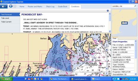
Note the CE2011 press release line about “new weather options such as support for XM, WX, weather, and free NEXRAD data.” I’m not sure what the first part of that means, unless it’s an elaborate typo for XM WxWorx, which would be neat for those willing to pony up that monthly subscription. And I haven’t seen NEXRAD in the beta program, but sure like the idea of adding that to CE’s otherwise pretty complete “Conditions” quiver. “Conditions” being the tab all this stuff is under, one of a tab bar that only appears when your cursor hovers over that top area (see screen shot above).
Henning,
I noted your comment about current consumption so, I did a quick measurement of a live Furuno Navnet 3D MFD8 system running at 13.8VDC:
MFD8 only, Max Brill – 1.42 Amps
MFD8 only, Sleep Mode – 0.8 Amps
MFD8 with DRS4D, Sleep Mode – 1.5 Amps
MFD8 with DRS4D, Max Brill-STBY Mode – 2.54 Amps
MFD8 with DRS4D, Max Brill-TX Mode Long Pulse-3.22 A
MFD8 with DRS4D, Max Brill-TX Mode Short Plse-3.05 A
You can ask the installation technician to put a switch in the radar power line to save 1 Amp STBY Power. This won’t hurt anthing.
Sleep mode’s 0.8 amps is 500% less than your assumption. This means the GPS, and all other background functions like waypoint backup to the MFD will still work fine while sleep mode. If radar is needed, turn on the switch and wait 40 seconds.
I beleive these efficiency numbers compare favorably with any MFD system on the market, including a Broadband Radar.
Plus, DRS Radars all have an NMEA2000 Port which is truly a way to provide an independent backup GPS/Wind sensor against the single point failures of a single backbone NMEA2000 network. Just flip the switch and the radar/GPS will be available without wasting energy when it is not in use. I’m studying how to include this type of switch in software as Ben has noted is available on some other systems.
Furuno Tech
Hmmm,
I’m stumped. $100 for CE.net for something Ive put so much work into, to get a European Release of, which always seems to fall on deaf ears these days.
I really dont know what to do now.
Steve
Furuno Tech,
Thank you very much for your effort in taking these measurements. My estimate was based on the specs and on asking the German Furuno branch who only looked at documents and didn’t do measurements. Indeed, these numbers are far better than I had thought.
Adam,
I understand that it applies to other Furuno MFDs but does it also apply to a computer running Maxsea TZ Explorer?
Could you both (and others, of course) comment on what I think are the relevant facts of running Maxsea TZ Explorer (NavNet 3D integration) when compared to a PC-only charting application such as Rose Point Coastal Explorer? I see the following main topics but you may correct me on those, too:
Connecting instruments:
– In order to be able to use other charting applications or N2K View or Weather Caster on the computer, the N2K bus must be connected to the computer, ideally via an Actisense NGT1 or else via an N2K/NMEA0183 converter.
– This is also needed to run Maxsea TZ by itself without radar and with the MFD off.
– For the MFD to do what it is supposed to do, the N2K bus must be connected to it.
– From other entries here I seem to remember that you can’t set Maxsea TZ to use the N2K data from the N2K bus connected to the computer if and when the MFD is powered up. Did I get this correctly?
– More specifically, if I started the trip with just the instruments and the computer and Maxsea TZ running, can I then turn the MFD with it’s radar on and off and on and off as I please? When looking at the MFD and the radar as one unit, that is either needed or not, this is a legitimate question. It is relevant to this topic because Coastal Explorer and the Koden PCradar provides this.
– What function would I lose if I didn’t connect the N2K bus to the MFD at all and what if the N2K bus were connected to the radar (and the computer) only?
Using radar:
– To use the radar, the MFD must be powered up (at least be in the “MFD8 with DRS4D, Sleep Mode – 1.5 Amps” state above). If you start the trip without radar and later decide you need it, can you then turn on the MFD, wait a little and be able to use the radar from Maxsea TZ?
– vice versa, if you started with the MFD powered up and later decide to turn it off, can you continue to use Maxsea TZ without radar as normal (as if you had started with the MFD off)?
Other uses of the computer and connection to the internet:
I strongly favor to not have a dedicated “navigation computer” so the computer running Maxsea TZ or Coastal Explorer will alternatingly be connected to my office network, my home network or be on the go (at clients) and access the internet via a cellular card. When on the boat, I also want to have continuous internet access via a cellular card when there is coverage. I am not a friend of WLAN connections as I have had nothing but trouble with a wireless connection from my Panasonic CF-08 display in the cockpit to my laptop at the nav station with it failing at the most inopportune time, freezing the screen in the cockpit without it being immediately apparent.
From other entries I understand that the dhcp server in the MFD must be activated but I don’t at the moment remember why. Is this so? And do I remember correctly that a default gateway can’t be set in this dhcp server so a computer connected only to this network segment and set to acquire IP settings from a dhcp server couldn’t connect to the internet?
If this is so, and if ruling out WLAN connections, which do you recommend:
– two network segments with a router in between that does not route dhcp packets with segment A having the MFD, the radar and the router and segment B having the computer, the router and anything else that I might want such as a WLAN bridge or a separate cellular router
– an additional USB LAN card connected to the computer which connects to the MFD and the radar and the existing LAN adapter connecting to everything else?
In either case I must set up a routing table using “arp”.
Chart formats:
In North America both Maxsea TZ and Coastal Explorer show NOAA raster and vector charts so no difference.
In Europe, the canaries and the Caribbean the situation is very different. A combination of Coastal Explorer, SeaPro and Fugawi would let me use every relevant electronic chart format. Expedition supports may of then, too. And three of them, Coastal Explorer, Expedition and SeaPro support the Koden PCradar.
What can you say about the quality of the Mapmedia charts outside of North America? How current? What source data? Both raster and vector available?
Using charts away from the boat:
How can I best set up Maxsea TZ and a MFD to access the chart data:
– on the boat underway with Maxsea TZ running but the MFD off
– on the boat underway with both Maxsea TZ and the MFD running
– off the boat, at home or in a hotel room using Maxsea TZ
Also, when off the boat, can I:
– buy and install new charts?
– update existing charts?
Coastal Explorer and any other PC-only charting application provides this.
I ask that you give hints on how to best deal with these topics and I won’t discount Maxsea/Furuno if perfection is not achieved in all cases.
While I am pretty happy with Coastal Explorer and would have (or will have) no problem with the subscription charge, I have misgivings about the only radar that it (currently) supports.
When reading the Koden PCradar documentation I noticed a striking similarity between it’s antenna and connectors and my existing Simrad Anritsu RA772UA stand alone LCD radar that came with the boat and is of 1997 vintage. When checking, I found that both use the exact same model of antenna unit, manufactured by Koden. This means that the PCradar currently sold uses technology at least 13 years old and it also means that what I see on my existing radar is a valid approximation of what I would see in Coastal Explorer, e.g. overlaid on a chart.
Two weeks ago we went up the Elbe river towards Hamburg. As often in such rather boring runs, I played with the radar. We were surrounded by 6 other pleasure boats that had been locked with us and there were plenty of navaids. I would have asked for better separation of the boats and the navaids and wouldn’t have been able to safely steer the boat from the nav station below using just the chartplotter (CE), the radar and the autopilot control. The worst part was that when we were overtaken by container ships presenting their broadsides, the radar screen was covered by a huge doughnut-shaped return with us at the center of the hole, completely hiding all the small boats and navaids around us. This was at 0.75m range. When zooming in at 0.25m, the entire screen was black. I was unable to tweak settings to see anything other than all black or all white.
By comparison, my favorite marine electronics installer described a situation where he tested a Furuno DRS4A open array radar connected to a NavNet BB unit on a client’s boat and passing along the Hamburg harbor floating dry docks for container ships at a distance of about 100ft. Although this is a similar situation, there were no distortions. And then, amazingly, the radar painted a sea kayaker *between* the client’s boat and the steel wall of the dry dock.
To Anonymous:
Yes MTZ might seem fine on the surface, but I&M have always followed a policy of add-ons for what is standard on most products these days, the Mobiles Module (AIS etc) Weather and Routing Module.
Add up the cost of the extras and the price increases somewhat. This is why I changed from Maxesa to CNP/CE in 2005 because I was unwilling to pay £400 for the AIS bolt on. The whole program for CNP was a lot less, OK it dint have Maxsea’a Extensive charting features and C-map support, but I got on quite happily with Admiralty Rasters anyway.
Now that the program has an odd look of a re-badged Admiral 7 about it, I dont think I’ll be going back there anytime soon.
Steve
Henning, yes, your Anritsu radar uses the RB714A antenna which we still support today. With the new MDC-900 series display connected to that antenna I can see seals and ducks at the 200′ range in the marina. And while electrically your old antenna is compatible, the RB714A we produce today still carries the same model designation, but would have several important updates and changes inside. Unlike some of the other manufacturers we haven’t spent a lot of time optimizing short range detection in our small dome radars. 13 years ago the 772UA was a good entry level radar for pleasure boaters. Today we sell very few 2 kW radars, we don’t price them and we don’t position them for the pleasure boat market. These radars are for the commercial fishermen, small tug boat operators, etc. – this limited market segment is less concerned about ducks at 100′, these are the people who want their radar to last 15-20 years. Most pleasure boaters, you’d agree, change boats and electronics a lot more often. Also, most of our customers pay more attention to long range detection, say 1 to 16 nm, very few people will try to deny that Koden radars do an excellent job at those ranges.
Some of the people who commented here earlier implied that if the processing is not done in the scanner, then the radar is not “digital”. Most commercial radars by most of the major radar manufacturers process the radar analog video in the display/processor unit installed in the wheelhouse, I haven’t heard a marine electronics professional call them analog or “analog converted” radars. All modern radars (except perhaps the BR24), as it has been pointed out several times on panbo.com, perform the conversion at some point, it is the quality and depth of this conversion that matters. The Koden MDS-5R Ethernet radar interface boxes do an excellent job of A/D conversion, competing with the latest “digital” units in the number of samples and speed, while assuring both backward compatibility so the users of the older stand alone radars can switch to a PC based system at any point and providing a measure of future proofing as well. So, Henning, if you wanted to use the Rose Point, Nobeltec or Euronav systems with your radar, you’d have better range resolution because the interface box samples more often per each radial and you’ll have better main bang suppression, on the other hand, the boats at the locks will still be bunched up, that’s the function of the antenna size. We find that either the 4 kW dome or the 4 kW open array do a very good job and that makes the price of the upgrade to the larger antenna very worthwhile.
To address another statement on this thread – MARPA or ARPA functions are handled (in case of the RADARpc) in software and are available from some of the software manufacturers who support the Koden RADARpc, the radar antenna (unless it is a antenna with a built-in processor) doesn’t handle these functions.
Note that Rose Point is hosting some discussion of the new update/subscription plan here:
http://coastalexplorer.net/news/39209
I hope that what Brad is calling a “a lot of confusion, speculation, and incorrect rumor about our new upgrade policy on the web lately” doesn’t mean Panbo. If what I described above is correct (and no one has suggested it isn’t), I think it’s a reasonable policy no matter what it’s called.
According to a Rose Point entry on their Beta forum, “We are extending Coastal Explorer Network services (other than upgrades) until March 15, 2011 even for those customers who purchased Coastal Explorer more than 1 year before that date.”
But the $100 update plan for CE 2010/2011 remains the same:
“The current Coastal Explorer 2010 Beta expires on Dec 31, 2010. At that time, it will revert to the Coastal Explorer 2009 user interface.
As we get closer to finishing things up, beta updates will be available that can be “upgraded” to the standard Coastal Explorer 2011 by simply entering a new activation code and that can be done over the Internet or by telephone.”
Here’s a detailed CE update update I missed (because it’s in the Support Forum):
http://coastalexplorer.net/support/forum/39444?qx=o9xq4z.3