
Nobeltec VNS & Admiral 11, the preview
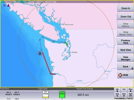
Real time fuel range — as when it’s calculated using actual fuel flow and tank levels — is darn useful information; for instance, it should let you instantly see the effects of RPM or sea state changes not only on your MPG but also on your ability to get somewhere without a forced stop. Which is why it’s neat that the Nobeltec 11 preview screen above shows the value as a number, as a circumference from your present position, and even as a distance along your active route. And there’s an implication to this screen that I’m sure many of you will welcome (and may have already figured out)…
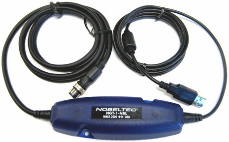
Yup, Nobeltec’s new version 11 VNS and Admiral navigation programs — intended to “launch within the next few months” — will support standard NMEA 2000 data, which will eventually mean values like fuel flow, engine sensors, switch states, and much else that is not available via NMEA 0183. Fuel flow is the only special N2K data PGN that version 11 has been extended to display so far, but all the PGNs which duplicate 0183 data like GPS, wind, depth, etc. are supported (AIS excepted), and there’s a Wizard to simplify the install. Nobeltec is obviously committed to the Standard, and AIS support, and more, will follow shortly. In fact, there will even be a Nobeltec branded N2K Gateway, as seen below, developed in partnership with Actisense.
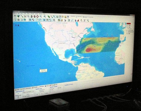
Nobeltec 11 software will also be opened up to NMEA 0183 data coming from Furuno AIS and NavNet devices via Ethernet. Which is not a big surprise as the two companies became cousins when Signet (MaxSea and MapMedia) bought Nobeltec last year. Similarly unsurprising, but nice, is how VNS/Admiral 11 will work with MaxSea’s popular, and free, worldwide GRIB weather data. On the preview cruise in Fort Lauderdale — below is a grainy night shot of a big display set up in the main salon of a lovely and Nobeltec-loving 92′ Broward — we got to see how easy it is in version 11 to select an area of desired GRIB data, Max Chopper style; the new programs will even put an automatic download boundary box around a route.
Nobeltec 11 will also support data import and export via the GPX format, a move which I think many will view as another sign that the product philosophy is getting more open and generous. Others may especially appreciate the improved NavBar configurability, or better display of Sirius Marine Weather, or the new InSight IR2-HD2 2kW, 17-inch radar dome, which claims twice the resolution of Nobeltec’s previous small dome, and uses an Ethernet connection like the bigger InSight models. Also demonstrated in Lauderdale was the iPad integration discussed here recently.
But the biggest news about Version 11 may be its mere existence, as I know some skeptical Nobeltec users were worried that they’d be forced to switch over to MaxSea. Well, a year later, with version 10.7 behind them and 11 ahead, it looks like Nobeltec is doing exactly what it promised — improving the original products with the benign support of a parent company that wants to retain Nobeltec’s large customer base. Yes, they spoke of evolving efficiencies between the two charting programs and I think we may see more Furuno hardware integration and maybe a switch to MapMedia cartography — any problems with that? — but I, for one, have little doubt that we’ll see Nobeltec VNS and Admiral versions 12 and beyond, and they’ll be interesting.


This looks promising! Being able to funnel all this data into the nav computer opens up a lot of new possibilities. There is so much processing power sitting there, going to waste, in many systems. It could be put to great advantage with all sorts of neat calculations. This range circle is just the tip of the possibilities. Statistical analysis of weather and route data, for example, could help a captain to figure out what route is most likely to avoid the worst part of a storm. Combining weather and sea state data with speed, engine performance and tank levels could lead to a range circle that accounts for head winds and sea state.
What I like about this is that the tedious, computational work is being offloaded from the captain to the computer- as it should be. What should be presented is a simple, clear visual representation of the final analysis, with the option to look at (and adjust) the details of the process if desired.
As for cartography…. I don’t particularly care who Nobeltec chooses to partner with. I do know that I, and many others, would consider interoperability to be a Big Plus, ie. the system should be able to read whatever charts I throw at it- S-57, CM93, S-63, BSB, Mapmedia, whatever. Proprietary and/or encrypted chart formats may help keep the business side predictable, but I frankly don’t see how locking a user into one chart supplier (when a different, incompatible set might be better in some regions) is of any benefit. Ten years ago, when there was less competition and it was hard to support more than a handful of formats, sure. Today? I can think of no legitimate reason why every chartplotter shouldn’t be able to read every common chart format.
(Oh, and Ben- any idea why the captchas keep acting up?)
It’s been a darn shame that S-57 support was pulled from the Nobeltec Admiral software. It did have it but their claim was that it was not possible to ensure quality charts if users loaded these S-57 government charts. Go figure.
That alone is driving me to move to other software. I don’t like doing that either because I’m giving up some features I really like. The logic behind pushing long-term and loyal customers away in this way escapes me.
Chuck
Hi, Wondering is VNS 9 can support a stand alone heading sensor ? I am receiving my GPS through Com4 & the heading sensor input is via Com 7 BUT dont see any response with the boat heading
Hi Ron, I don’t think that VNS supported input from two com ports, but it should be fairly easy to run the GPS and Heading info into an NMEA 0183 multiplexer which would then go to one port. The Actisense NDC-4 with USB output is one of many possible solutions: https://actisense.com/products/ndc-4-nmea-0183-multiplexer/
Meanwhile, I’m quite curious about how you’re running VNS in 2023 given that Nobeltec ended support almost a decade ago. Does it work on current versions of Windows? Do you have a source of updated charts?
https://panbo.com/hello-nobeltec-timezero-odyssey-goodbye-vns/
Hi Ben, It definitely appears to not be reading the heading sensor! I recall years ago when AIS first hit the street some version of VNS i was using seemed to receive input from 2 com ports ” I will just call them A & B” com A was the GPS & com B was the AIS you had to assign manually because the wizard would get confused, the heading sensor I am using is a Garmin Steadycast NMEA2000 version, the PC is a Win 10 version, I am using the Actisense NGT-1 to get NMEA2000 into the USB port, the heading sensor works just fine using Rosepoint & Time zero that I have in the same computer, but it just dont seem to work with VNS9 ? or I am missing a step???, Nobletec gives you there legal disclaimer about using VNS past there support date but I found it works just fine in a windows 10 PC, as far as chart updates NO, I open Rosepoint or TimeZero if I need to see a updated chart. My first VNS was a bootlegged version of VNS4 in 1999 & sense then I upgraded op until VNS9 then for some reason Nobletec took a radical left turn & started down a whole new path that I have NEVER fully embraced (I understand the need to change & keep improving a product to stay abreast of new technology BUT!!!) Im a did hard VNS user & Rosepoint is a close second! any thoughts or suggestions on the above are appreciated. thanks Ron