
Hello Nobeltec TimeZero Odyssey, goodbye VNS?
The great news is that Nobeltec rolled out TimeZero Odyssey last week, and the introductory price for existing Nobeltec VNS and Admiral software owners is a compelling $199, as seen at retailers like P2 Marine. Odyssey seems to be the same core charting program that I’ve been enjoying all season as TimeZero Trident, except that it can’t integrate with radars, sounders, or video cameras (thermal or otherwise), and it doesn’t support dual monitors, fuel management, or Nobeltec’s Ocean Data Service (for serious fishermen)…
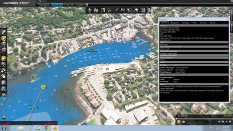
Now, I became a fan of Furuno radar integrated with the TimeZero PC charting engine even before I upgraded to Gizmo’s Chart Table 21 rig. But the software involved — whether you go with MaxSea TZ Explorer or TZ Trident — rings in at well over $1,000 and you also need a Furuno NavNet3D MFD on board and running. Meanwhile, a major benefit of TimeZero is its gorgeous chart presentation, especially with MapMedia’s high res and “fused” photo maps, all of which are free for U.S. waters. For instance, notice how nicely the screen above shows the moored boats in Camden Harbor, or check out the Odyssey video on YouTube.
One other caveat of TZ Odyssey is that it only runs on Windows 7, which I guess is an attempt to minimize customer support hours, but not a huge deal when these days you can buy a zippy Win7 PC for small money (like the 17-inch LED HP laptop I recently picked up). It also takes a fairly powerful PC to fully appreciate TimeZero, and it’s getting pretty obvious that Nobeltec wants to impress and switch over its large customer base of VNS and Admiral users.
In fact, though I don’t see a word about it on the Nobeltec site, the recent P2 Marine newsletter states that: “In other news today Nobeltec announced that during the spring of 2012 VNS/Admiral 9 and Passport Charts will no longer be available. Nobeltec will continue to sell and support VNS/Admiral 11 through 2014.” I suppose some die hard users of older Nobeltec products may howl, but I think they’ve been treated pretty well since Nobeltec became part of the MaxSea/Furuno empire. I’ve also been running Admiral 11 this season and can attest that it’s a solid program with good AIS and NMEA 2000 support, and excellent presentation of Jeppesen C-Map Max Pro cartography…
But even if I was running VNS or Admiral 11 — let alone an older and, hence by definition, clunkier version of Nobeltec’s original charting software — I’d sure give TZ Oddyssey at $199 serious consideration.


There’s a dearth of sub-$200 nav packages out there that won’t do radar, won’t do sonar, won’t do polars, and won’t do advanced Wx-related route management. Now we have another. Satellite imagery overlay is eye candy I can live without. I’m curious what the future may hold for a lightweight incarnation of Expedition for iOS (and/or Windows 8 running on an ARM-based pad).
Brian, have you sailed with TimeZero high res fused photo maps? They’re not just “eye candy” even here in the fairly opaque waters of Maine, and they must be sensational in Bahamas and similar areas where they’re available. I noticed a while back, when Navionics Platinum+ was introduced ( http://goo.gl/bW58z ), that the value of photo maps seems to increase exponentially with resolution, and well done “fusion” is the cherry on top.
I don’t know anything about an iOS version of Expedition, but maybe Nick White will comment. I do know that Nick is helping America’s Cup Race Management with a some special Expedition tweaks, and I’ll write about that soon.
I find this very interesting. Due to unforeseen circumstances I decided to upgrade to Trident this past September. I don’t need any of the ties to radar, etc. but, obviously, the only one on the market was for $700. There was no mention of a reduced version, even no word at the FLBS, but now there is. I feel a little taken. I always thought, generally the first individuals in on a new product got the favorable treatment. However, in this case I feel we got taken, about $500 worth. I have had a couple other cases of selected wording with Nobeltec and certainly recommend you take a look at all navigation software. While their product may be good, I believe their business ethics leave a little to be desired.
Ben or anyone else — If you were choosing between MaxSea Explorer and Nobeltec Trident to use with a Furuno MFD (and get wide screen radar display), which would you pick? Is this a flip a coin choice or is their a reason to go with one or the other? Also is there a good reason to buy a large MFD, when one can use one or two PC monitors for the same purpose?
I have only experienced the garden variety Google Earth satellite imagry, so I may be speaking out of school on this subject if the resolutions in question are much higher and the exposure quality can be relied upon to show obstructions or narrow passage boundaries. Will have to check it out to see how it fares on known gunkoles and tricky channels here in the Northwest. Thanks as always for the extremely informative posting.
I agree with Doug about Nobeltecs ethics. I upgraded to VNS11 following the release and advertising only to find out within a couple of weeks that I could have purchased Trident at a reduced price. I have stayed with VNS but would be upset if I had gone to Trident now that Odyssey has been released
Great minds think the same.
This caught my eye because in 1996 or thereabouts, ancient history to most, I was working at Weems & Plath and we were negotiating with Nobletec to develop a more affordable navigation program. The result was “Weems & Plath Chart View ‘Odyssey'”.
I think in the end it was a way for them to get some extra revenue out of a soon to be dead product.
Now they recycle the name, it works for me. If this product is analogous in features to the first Odyssey as compared to Chart View it will be a great value.
Aerial photo overlays could certainly come in handy in some tight places, if they’re done well and don’t get in the way when they aren’t needed.
I can’t shake some cynicism on the pricing scheme, though.
If you’re going to use government-issue S-57 and raster charts, what does Odyssey offer that free alternatives such as OpenCPN don’t?
And if $200 is a good price for the base software, is $300 per proprietary chart set is a good price for the data you have to buy in order to make full use of it? MapMedia charts are pricey; C-Map charts are even pricier. They really add up if you venture out of your home turf. (The “free in US waters” argument doesn’t count for much to Canadians, Europeans or most others.)
Don’t get me wrong, I’m glad to see some more competition in this sector of the market. Still, I’d happily settle for less eye candy if those development resources were, instead, directed at supporting a broader variety of chart data sources and at extending the system’s abilities beyond American borders.
“…what does Odyssey offer that free alternatives such as OpenCPN don’t?”
Matt, the TimeZero charting engine is unlike any other program out there at any price. I’ve put up a lot of TZ screen shots over the last few years, but it’s hard to see what it’s really like without a video or, better yet, trying it.
“If you’re going to use government-issue S-57 and raster charts…”
This is actually somewhat the Achilles heel of TimeZero. It won’t show straight-up S-57 and raster charts. They have to be processed by MapMedia to work in TimeZero, and that means that TZ charts are never as current as, say, Coastal Explorer’s NOAA charts, which can be updated automatically almost to the revise date.
On the other hand, I hope that Rose Point (developers of Coastal Explorer) is revising its disdainful view of 3D charting in light of how usefully it’s done in TimeZero.
Razors and blades. This is another razor for MaxSea’s blades (aka charts). Which is good for everyone who uses Time Zero charts (like me).
Think of inkjet printers; they virtually give them away so you’ll buy cartridges.
The market is cleanly bifurcated into those who’s primary goal is to sell charts (MaxSea, Garmin) and those who are trying to sell software.
Now if MaxSea is smart they will gradually lower the price of Time Zero while slowly (so as not to piss anyone off too quickly) increasing the price of the specialty modules designed for commercial customers (e.g., Furuno’s commerical fisherman). That will drive more business for their charts while not eroding the fat software margins on the commercial products.
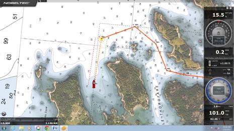
I don’t ever use the 3D features, but the speed and seamless zooming of Time Zero charts is fantastic. Changing would be like going to back to a rotary dial telephone.
I have to support Ben on the 3D and high resolution images. I really was too busy to download the hi res images until I saw a posting by Ben. I’ve since downloaded the “free” high res images for the East Coast and went further and bought the Bahamas images as well.
I was unhappy about TZ being able to only utilize Mapmedia charts for two reasons. First I had spent quite a bit maintaining my c-map charts, and second, the addition of yet another delay in getting access to updates. The hi-res 3D overlay, not the panning and zooming speed is the display wow factor for me.
Hello,
As others have said above the market is split right now between some attractively priced software with expensive cartography or the MFDs. The limiting factor is the interfaces to Radar, AIS and weather. All of the MFDs have a radar option, the PC software is very limited. As Furuno and Raymarine continue with their long standing product lines, Garmin seems to be gaining on them.
I am surprised Nobeltec does not offer a competitive discount to try to cut into other brands instead of just anoy their own customers.
As someone who has used almost every single navigation suite, I must say that when I first fired up MaxSea’s TimeZero software I was completely blown away. After downloading and installing the Hi-Resolution Photo-Fusion charts, the program immediately jumped to the top of the pack. Enter Nobeltec Trident, with a more Nobeltec-user friendly interface, along with the download of the Bahamas Explorer Raster charts and Hi Res images, I fell completely in love. Now Nobeltec has added the Sailing Plus pack to Trident and Odyssey, providing GRIB and Polar management, along with their isochrone auto-routing, and now there is legitimate contender to Expedition for distance race navigation.
On another note, some here may complain about Nobeltec’s ‘business practices’ regarding the timing of the software releases, however you need to understand that all of this software is in constant development, and release dates are dictated not by a grand profit scheme, but by hundreds and hundreds of debugging hours. As soon as the product is ready to deliver, bug free, it is released. The Sales team, dealerships, no one outside the little room the software is being developed knows when these programs are going to be released until the public knows. Trust me on that one.
Nobeltec has, in my opinion, done right by offering a huge discount to loyal Nobeltec users, and have supported their legacy products long after they truly needed to. It would be much easier to simply shut out the VNS and Admiral users with a discontinuation notice and force everyone to either buy Trident/Odyssey or walk, but every effort has been made to keep everyone happy.
As for me, my dream system will still remain to be an MFD8 running a DRS4D, a KEP Leviathan PC running Nobeltec Trident on a 15” Dual Touch Display (Also a KEP Marine) with a FLIR M324L being controlled via the Trident interface ( See bottom of https://panbo.com/archives/2010/02/mibs_me_lots_happening_all_good.html ) on a Cutwater 28 (Forest Green Hull). Until then, I will have to live vicariously through Ben as he motors Gizmo into the Sunrise.
I was wondering how you ordered the mapmedia raster charts of the Bahamas. Their catalog only shows Caribbean and Western Caribbean raster charts. According to the catalog, there is no raster chart coverage of the Bahamas. Did you mean the Mapmedia C-map charts which incorporate the Explorer data?
Thanks
Don
Hey Don,
The Nobeltec SKU # for the Bahamas Explorer Raster Charts is WR-901. They are, as you mentioned, the MapMedia revision, not the Jeppesen Vectors. They were updated actually just three weeks ago. Very nice job they did with the rendering of the Explorer Charts. Not to be a shill, but if you click on my name, it will link you to our company contact info where I can provide you an unlock code with a download link along with a 15% “Panbo Discount”, or at least point you in the right direction.
Hey Dan, wasn’t sure if I could double post on Panbo, but here is the download link to the Bahamas Raster chart kit. http://www.mapmedia.com/charts-catalog.html?zonename=WR01MAP
The .DBR file is the actual raster chart, .DBT is the 3d file, and the .DBA file is the Low-Resolution Satellite imagery, unnecessary if you already have the Hi Res 908 Photo pack.
You can use that site to search for and download all the updated Mapmedia/Jeppesen US Raster and Vector Charts, along with all the High-Resolution satellite imagery. All the US files are free to download and install, the rest require an unlock. Good luck!
Thanks,
I think if you look at the naming convention Mapmedai uses, WR01MAP references a 2D chart.
I have the 908 hi res photo pack which is great.
Don
Don, I think you’ll find that TimeZero software can render any and all MapMedia charts to 3D, though the .DBT file of regional bathy data that the good Chris (Labozza) mentioned is needed.
Well,
I bit the bullet and looked at the detail information regarding this chart again. The highest-level cover say info says that its a C-map vector chart and inside it says raster. There you go. I previously stopped there simply because the search for Bahamas raster charts turned up empty and this explains why — it was mis-cataloged. With an empty set, I assumed it must be a previous generation chart. My sincere apologies to Chris who clearly knows the quirks of the MapMedia catalog. Sorry!
Ben, you’ve gotten my attention. How can TZ render into 3D any MapMedia chart? The earlier (pre-TZ) MapMedia raster charts were 2D products (ie scans) without info regarding the land topography.
I misspoke, and should have said that TimeZero can render any MapMedia chart in its .mm3d format into 3D. But I think that includes pretty much all of MapMedia’s catalog at this point. Actually all 3D rendering is done by the presentation software using bathy info that’s built into the chart file or separate, but TimeZero is unique for treating 2D and 3D the same, and apparently the .mm3d format makes that faster. Then again TZ won’t do a thing with any cartography that isn’t in .mm3d format.
This just in, for any Admiral or VNS users with a Max Pro or Passport chart collection thinking about moving to a TimeZero platform – 50% off of all MM3D Chart Regions to VNS/Admiral owners.
http://www.icontact-archive.com/vV_S7cxfD7i7bqvaOy9uPGbmZcn5nqBt?w=4
Hi Ben,
I think what you have missed in all of this is that Nobeltec have treated their existing customer base of VNS and Admiral users abominably: First they bring out Trident and call it a “new product” and therefore offer a high “transfer price” and worse still all of our old Maxpro charts are unusable. (I had just paid them over $1000 to get the latest versions of my Maxpro charts just two weeks before Odyssey came out.)
And then, only after milking the base of VNS and Admiral users for a high transfer price for the very expensive Trident, which most of us don’t need, they then bring out the less expensive Odyssey, which would have met most users needs anyway. I don’t think this timing was any accident.
Yes, I’m sure Nobeltec will argue that Trident is a new product and support will still be in place for Admiral, yadda yadda. But I know when I’ve been had, and I remember too. We are sticking with Admiral for now and looking at other vendors who treat their customers better, for the future.
I disagree pretty strongly, John. The reason Trident is expensive is not because it’s new but because it interfaces with complex hardware. Charting developers have always charged extra for that, and one of the reasons is the potential additional customer service.
I’m pretty good at this stuff, and Trident includes some excellent install tools, but I still needed a serious tech support session to get the Furuno integration right last summer. While I was talking to one tech on the phone, another WiFi’d into Gizmo’s PC, looked around, and showed me how to fix the problem right on my own screen, which was pretty impressive, but expensive for Nobeltec.
And, sorry, but I’m dubious that many Nobeltec users switched over to Trident who didn’t want its advanced features. Trident is obviously the near twin of MaxSea TZ Explorer, which I noted at introduction: http://goo.gl/EqLLX. MSTZ Explorer is a premium product designed to interface with Furuno hardware and it costs over $1,000, so the Trident transfer at $700 isn’t a bad deal. But there’s always been a plain version of MaxSea TZ — something like VNS is to Admiral — that retails at around $450. Wasn’t it predictable that Nobeltec would eventually clone that program too?
Besides, no Nobeltec owner has been forced to switch over to TimeZero. In fact, the new owners obviously put a fair amount of resources into the bug fixes and improvements seen in VNS/Admiral 11, even though I’m sure they’d rather be putting them into their core MaxSea products. John, aren’t your MaxPro charts quite usable in Admiral 11?
Finally, John, wouldn’t you be fairly content if Nobeltec still only offered the VNS and Admiral programs MaxPro charts? And if you did want to switch to TimeZero technology, wouldn’t you have to spend a lot more monay? What am I missing?
Hi Ben,
I guess we will just have to agree to disagree on this point. I just can’t for the life of me see how anything you wrote above applies to my point.
As to the “altruistic” upgrade of Admiral to version 11, hardly, I paid them, if memory serves around $400 for that, on top of the $1000 for upgrades. And that just before the announcement of Tridant.
For me, the key issue is that sooner or later Admiral will be discontinued, just as VNS was, and at that point there will not be a viable and reasonable cost path to the new technology.
So we Admiral and VNS users are faced with either spending a bunch of money now, and throwing all of our charts away too, or doing it later. Only later it will be more because the “special” offers will be over. Pardon me if I’m not happy.
I think that what gets missed by those of you who are fascinated with the latest wiz bang piece of technology is that many of us, particularly those of us who sail offshore in challenging conditions, just want a solution that works well with an easy and reasonably priced upgrade path from a company that we can trust to have our best interests at heart over the long term. Just makes me old fashioned, I guess, but not, I suspect alone.
(Note: we just completed a 10,000 mile Arctic cruise to Greenland and Baffin Island using Admiral and Maxpro, and it worked great.)
The idea that the Odyssey’s release timing was the result of software development imperatives is, with respect, probably wrong.
Although I may sound old fashioned (see my comment below) in fact I spent some 20 years in the software development business.
And, based on that experience, I would just about guarantee that the only difference between Trident and Odyssey is a few software switches that are set when the same piece of code is compiled. That is simply the way modern object oriented software development is done.
And that, to explain for the lay person, means that the day Trident existed in ready for market form, so did Odyssey. And if that’s true, what does it say about ethics?
Just as an aside, did you know that there is just one operating system at Apple. Set a few switches at compile time and you get a Mac, set them a different way, and you get an iPad. That’s just the way its done.
“Note: we just completed a 10,000 mile Arctic cruise to Greenland and Baffin Island using Admiral and Maxpro, and it worked great.”
Well, John, I guess that answers my question, “wouldn’t you be fairly content if Nobeltec still only offered the VNS and Admiral programs MaxPro charts?”
The point I was trying to make is that the advent of Trident and Odyssey don’t change the utility of Admiral and VNS at all. So where is the lapse in business ethics? Within a week of me buying an Apple Mac Mini last June, Apple announced and started shipping a better and less expensive model. Was it unethical not to announce it sooner? I slapped myself for not paying closer attention to the typical product cycles and the rumor mill, but I didn’t blame Apple, and the Mac Mini I have works as expected (very well).
Here we are more than two years after Nobeltec was bought by its competition. That was a pretty puzzling move, and I tried my best to figure out what was going on and what might happen:
https://panbo.com/archives/2009/10/maxsea_buys_nobeltec_now_what.html
It strikes me that Signet (MaxSea/MapMedia/Furuno) has done pretty much what it said it would. They really did fix and improve VNS/Admiral, even though — as you note — the imperative in software these days is to get all your products into one manageable code stream. The committment seemed so strong that I even thought there might be a VNS/Admiral 12 eventually: https://panbo.com/archives/2010/11/nobeltec_vns_admiral_11_the_preview.html
But wouldn’t that be extraordinary given the circumstances? I have no idea what the actual deal was between Jeppesen and Signet, but I doubt that Jeppesen paid Signet to assume the support obligations it had to recent customers. Nor, obviously, did Signet buy Nobeltec for the code. Heck, MaxSea had already undergone the pain of starting fresh (time zero) with its own code.
I’d guess that little if any money changed hands, Jeppesen got rid of an under-performing division, both companies were happy to become chart partners (which is good for us, too, I think), and Signet got the chance to expand its base of charting software customers in exchange for taking over the support duties. You and others seem to think they blew that opportunity, but I don’t understand what they could have done better.
Two years later and you’re happily sailing 10,000 miles with Admiral 11. There may never be an Admiral 12, but apparently “Nobeltec will continue to sell and support VNS/Admiral 11 through 2014.” Isn’t that a darn reasonable run by any software standards? Meanwhile you and other Nobeltec owners have been offered a migration path to a rebadged (or arguably slightly improved) high end version of MaxSea at a price substantially lower than anyone else pays, and ditto now for the standard version.
I don’t know why Trident and Odyssey intros were timed the way they were, but would it really have been more ethical to keep the product lines completely separate? Would anyone have been surprised or outraged two years ago if Signet had simply shut down everything at Nobeltec except the support lines and started sending out MaxSea discount offers?
Incidentally, John, if what you really want is TimeZero and you don’t need the Trident version, why didn’t you just buy plain MaxSea TZ ($339 at ActiveCaptain) instead of upgrading to Admiral 11 for $400?
Finally, congratulations on your latest voyage, and thanks for documenting it all so thoroughly. I regularly run into sailors who are grateful to you and Phyllis for inspiration and help, and today I finally added Attainable Adventure Cruising to Panbo’s blogroll, which I meant to do a long time ago.
Hi Ben,
All interesting stuff. However, I think you and I just look at these things differently, so let’s just agree to disagree. I’m not alone in my attitude to Nobeltec’s actions, and neither are you, I’m sure.
Thanks for the kind comments on the site and adding the link.
Same goes for Pambo: a really useful resource that I often recommend.
As one of the apparently soon-to-be fossilized Nobeltec users I want to know why I should switch to this version since it doesn’t have the advantages of familiarity and reliability and apparently doesn’t suport the C-Map charts that I have a very large investment in. (I spend a lot of time in Canada.)
Three dimensional display is pretty but I have had it for years on both Nobeltec and Garmin and find it to be of limited use except on very boring days. Three-D requires you to be virtually in one spot to have a point of view as opposed to a chart that shows you a sweep of tens of miles worth of hazards at a glance. I (seriously) would like to see an explanation of the value that it adds over the hydrographic conventions worked out over centuries.
For this new program and any others, the features that I use and care about are:
Anchor watch
MARPA
Radar control
Hand Routing
Auto routing
Tide & current prediction
Log
Wind speed charting
Waypoint arrival prediction
AIS target display
Chart availability and coverage
Chart presentation.
Reliability — that is the big one, Nobeltec has brought me home when both Raymarine and Garmin have failed me.
These are the sort of things that I would like to see “graded” in some future review or “shoot out.”
For example, my Garmin has a fair implementation of AIS targeting but it has a really annoying and distracting way of dealing with possible collision targets — just when you need to be looking out the window you have to be pressing buttons to silence the alarm. Nobeltec is the only program that I know of that lets you set anchor watch properly (but unintuitively) by allowing you to create a range circle of any size at any location. Garmin’s auto routing is fantastic but you can only search by named services, not by landmarks.
Etc, etc. It is pretty hard to do a thourough review without living with the product for a long time but I think of anybody you are in the best position to do it, and humbly request that you consider such an endeavor.
“soon-to-be fossilized”? George, apparently Nobeltec is committed to supporting VNS and Admiral through 2014. So they’re not forcing you to switch, and I just suggested giving TimeZero “serious consideration” at $199. I’m interested to know how many VNS and Admiral users have software that they already been using longer, and for which they assured support through 2014. I know that if I ever clean out my office, there will be lots of manuals and how-to books for software I don’t have installed anymore.
As for “hydrographic conventions worked out over centuries” that’s a very interesting topic to me. Were they not worked out for the limited presentation abilities of a printing press? I am in forever awe of the conventions our forebearers developed to cram useful data onto a two-dimensional, fixed-scale paper chart and I remember well when the highest aspiration of a chart plotter was to look like a paper chart. But, wow, how naive that seems in hindsight.
TimeZero 3D is not like Nobeltec or Garmin 3D, not even close, and we’re still very much in the early stages of what chart presentation can be in the world of high speed processors and nearly infinite data layers. You’re right that North-up 2D has its place for planning, and maybe always will, but I firmly believe that underway 3D is the future. Because it can present the features and hazards around us in a way that’s much easier to relate to what we can actually see. When done right 3D charting can help you keep your head out of the boat, as I wrote here http://goo.gl/ZguvL Admittedly, few salty readers agreed with me, but maybe that’s what salt does to folks 😉
When you are using a product that nobody would actually buy because it is supplanted by something better you are a dianosaur which is the word I would have used if it were easier to spell. The year 2014 is only three cruising seasons away.
I, too have lots of old manuals for programs that I have forgotten about, but those programs were not attached to $20,000 in hardware that cost maybe twice that to install (don’t get me started on shipyards.) Then you add the charts, the upgrade services for the charts, the upgrade to Admiral so I could have two MARPA radars when going to Alaska and perhaps you can understand why some of us are a bit concerned about Nobletec’s glide path.
The problem with the $199 program is that it doesn’t work with any of my hardware, which makes it useless. To get Trident that works with my Nobeltec Insight radar will cost $2,000 — at the discounted prices! Then it looks like I have to get all new charts for Seattle to Alaska (the free US charts from NOAA are still missing some charts that I care about in the US.)
I think manufacturers are coming from a position where the more reality on the computer screen the better. A counterpoint is my Garmin’s XM weather display. If I enable “show clouds” it nicely does that — completely obscuring the chart where there is thick fog! Very realistic but not ideal from this user’s point of view.
You cannot ignore the tremendous amount of information that can be imparted by abstractions such as chart conventions. If you have an air draft of 23′, a draft of 10′ and want to go up a river with four bridges, you can determine whether that is possible in seconds using a traditional chart format. A 3-D simulation would require you to “fly” around the bridges in turn to see if your boat graphic fits under the bridge graphic.
For a real example, consider going up Wrangell narrows. There is pretty much one way to do it, but at each point there are a number of dead ends that one could start up. It is fortunate that there are old technology buoys which are marked on the chart. That is not a case where I think that 3D realism adds any value, at least for me where the main thing my gut wants to know is “how much more of this until we are done?” I’m more interested in the safe path rather than nice pictures of all the scary rocks outside the path.
As a programmer I love new technology and interfaces but as a boater I have found that having the charting system quaintly reproduce flat paper charts is the most useful for actual cruising in unknown areas. There are lots of tradeoffs with 3D. For instance, my Garmin’s 3D only shows what is ahead of you — not the ferry coming up behind you. It looks like TZ lets you fly up to the sky which is an improvement, but if you really want to avoid big fast ships you have to be centered in the top of the sky, looking down. This is exactly what I have already in the traditional view!
I’m not arguing that there will never be a better interface for presenting navigational data, but I’m not sure that realisim is the way to go for actual navigation. It is fun to play with because it is almost like boating, but when you are actually boating you need something else. In my opinion, at least.
Keep up the good work, by the way.
Thanks, George. And by the way it’s “dinosaur”…but I wouldn’t know that without Google, and you’re not one.
I thoroughly agree that 3D is not right for planning.
I contend that planning and operating are two entirely different navigation modes, and I like the programs like Admiral, Coastal Explorer, and TimeZero that are organized that way. I further contend that when underway and using a route, 3D done right is, or will be, the way to go.
There is new Furuno stuff coming down the pike. I knew the hardware was getting a bit long in the tooth and in need of a refresh and it looks like the new stuff will be touch screen enabled. It is advertised on the back page of the January/February Ocean Navigator. It is called “Navnet TZ” which must be some play on “touch and zoom” with pinch, zoom and whatever. The “Worldwide debut” will be at the Miami Boat Show 2/16/12. Hold on to your checkbooks!
Right, all they’ll tell the press so far is touchscreen. But I’ll bet $10,000 that TZ stands for TimeZero. It will be interesting to see how they’ve changed the interface now that it’s touch (probably along with some buttons and a knob?).
Just kidding about the 10 grand.
PS Steve, if you (or anyone) could scan or photograph the NavNet TZ ad and send it to me, I’d be most appreciative. And maybe we could have some fun trying to guess what Furuno is up to. Email ben (at) panbo.com. Thanks in advance!
Thanks to Steve, I have now seen the NavNet TZ ad. But it’s nearly all tease with no details. What you see is a hand doing a two finger something — zoom, rotate, I’m not sure — on a familiar NavNet/TimeZero style 3D chart and photo map screen. The hardware looks like a monitor with no buttons or knobs except that it’s deeper. But it’s also big enough that it might be a model with separate keypad. And some of it is blurred out…
The headline is “Touch…and…GO!” with 60’s hot-rod-style flames trailing off the “GO!” So I’m guessing it has a fast processor 😉
Ben: have you gleaned anything further on NavNet TZ? Is it hardware alone…or new software to replace Navigator/Explorer?
VNS is already technically dead. I have version 9.2 and we are out sailing in Central America –Funny how we don’t read that fine print and note we are only renting the software, when it was ‘purchased’– when my hard disk crashed on the PC and so I got another PC to replace the old one. Like a good sailor I have my full back copy of my last upgrade of VNS on board just in case something happened to the PC. So I have reinstalled VNS on the new PC but Nobeltec will not let me have a new site key. In fact it was mentioned that the site key database was shutdown (destroyed?) on purpose and is no longer accessible.
The end dates of Nobeltec “legacy software” are official:
“We will end sales of VNS, Admiral and Tides & Currents, as well as the Jeppesen MAX Pro charts on the following dates:
VNS 11, Admiral 11 and Tides and Currents 3.7: December 31st, 2013
Jeppesen MAX Pro charts: End of February, 2014
Technical support for these products will end on September 30th, 2014.”
It may be no consolation for some, but I saw a preliminary manual for Nobeltec/MaxSea TimeZero iPad this morning, and it suggest a really promising app.
when or will Nobeltec ever run on Mac OS?
It won’t
I suspect that anon is correct, but I’ve been running TimeZero on a Mac Mini using Boot Camp and Win 7 for years without any problems.
TZ Navigator V3 looks very interesting, by the way:
http://www.nobeltec.com/products/software/tz_navigator
Have been using new the V3 professional for 3 months now and its outstanding. Its great for fishing so don’t quite know if for sailing its any good. Reinstated the cube and additional functions which are very good. Also using with the Furuno sounder option which eve more friendly that the TZT interphase. Long time Maxsea user and I find it a major update.
I also have V3 Professional for a few months and am in general happy. Sailing specific features appear unchanged. Access to gov’t issued charts a real plus if you need the most current charts, although the price is a bit outrageous since this used to be offered at no additional cost with earlier versions of MaxSea. Nonetheless, I also understand that I also want the company to stay in business…..
I wish Maxsea would offer a 7-30 day trial period. It is a lot of $$ to drop without having the confidence that you will like the software, especially considering when you want to add the Sounder and Routing modules.
Nobeltec is a scam!
Not only do they claim that no site key is given out anymore, but nevertheless put one in my pc after big discussion. So all a lie! Old maps will not work with newer versions. All my maps from VNS 9 are useless. I paid good money for it and there was no rental agreement. No, the maps are fully mine. So screw them and purchase a nav software like coastal explorer. Better company than nobeltec scammers.