Category: Navigation

Northwest Passage with Starpath, plus its nav rules app 4

Northwest Passage with Starpath, plus its nav rules app

Starpath_Quark_NW_passage_cruise.jpg

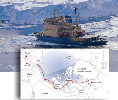
Twenty-three days on a Russian ice breaker following Roald Amundsen’s 1903 route through the Northwest Passage? Hell, yes, especially with David Burch — navigator extraordinare, and founder of Starpathriding along as tutor and guide to the vessel’s bridge. If I had the money and the time (heck, it took Amundsen three years), I’d seriously consider this opportunity. For one thing, the venerable Kapitan Khlebnikov is going back into government service, and this may be her last Passage passage. And for another, the high latitudes — where compasses, celestial navigation, and even many forms of modern communications all get dicey — are what nav-obsessed gents like Burch live for…

Simrad NSS series, touch sensible? 20

Simrad NSS series, touch sensible?

Simrad_NSS_series.JPG

Say hello to Simrad’s new NSS Sport series of multifunction displays — the NSS7, NSS8, and NSS12 — which are making their global debut today. They seem to have all the capabilities of the NSE series (which they can network with) plus a built-in GPS and, in the case of 7- and 8-inch sizes, a built-in Broadband fishfinder as well, along with quite competitive price tags (suggested retail prices of $1,895, $2,845 and $3,995 respectively). But the key feature is an LED backlit touch screen that is nearly as bright (1200 nits) as the NSE’s (1500), and which Simrad has used to create a combination knob, button, and touch interface it’s calling “Touch Sensible”…

The LightSquared problem, time to join “Save Our GPS”? 119

The LightSquared problem, time to join “Save Our GPS”?

LightSquared_GPS_jamming_test.JPG

When many readers sent me the GPS World article on GPS jamming, I was blasé.  How could the U.S. government possibly allow LightSquared to put up 4,600 transcievers pumping broadband data services in the L band with such power that they’d significantly interfere with nearby GPS frequencies?  As in complete failure at over half a mile for a high quality civilian GPS receiver like the nüvi 265W, even under an open sky, and almost six miles for a critical GNS 430W aviation unit (as ascertained in lab testing done by Garmin and Trimble, results PDF here).  But then again I never thought our government would be dumb enough to kill the eLoran GPS back-up system just to save a few dollars…

MIBS #4:  FLIR & PYI Seaview, Furuno & Oceanview 3

MIBS #4: FLIR & PYI Seaview, Furuno & Oceanview

PYI_Seaview_3FL_Pod_cPanbo.jpg

Here’s a clever idea.  PYI worked with FLIR to create an accessory podlet for several of its Seaview MFD pods that serves as an integral casing for a relatively inexpensive (“just over $2,500”) thermal camera core.  The core’s output goes to the video input of whatever MFD is mounted on the working side of the pod so the user then has a simple forward-looking thermal view that can even be aimed using the pan and tilt abilities of the pod.  There’s a major limitation to this idea — the fact that thermal can’t see through glass or plastic — but I can think of situations where it might make a lot of sense…

PolarView, ready for prime time? 36

PolarView, ready for prime time?

Polarview netbook.jpg

I took a peek at PolarView NS charting software about a year ago, but didn’t write about it because I wasn’t especially impressed (and there’s a certain randomness to what I cover anyway).  But times change and software develops, and I’m here to tell you that PolarView 1.5 (video introduction here) is pretty darn impressive.  Given its app-like $40 price tag, it’s a remarkably powerful program that runs on Windows, Mac OS X, and Linux operating systems.  The screen above shows PV running on my little ASUS Eee PC 1000HE 10-Inch netbook
with live NMEA 0183 data coming from the lab’s N2K network via a Maretron USB 100.  PolarView is quite unusual in that it uses a sister program, called PolarCOM, to do all its data interfacing and instrument displays… 

“GPS testing”…or do they mean jamming? 39

“GPS testing”…or do they mean jamming?

FAA_GPS_warning_Jan2011.JPG

This seems odd.  Yesterday the FAA issued a Flight Advisory — PDF here — warning that during a period of “GPS testing” starting today aircraft transiting the large area diagrammed above could find that “the GPS signal may be unreliable or unavailable.”  WTF?  But never mind sites like Engadget which immediately assumed that “anyone planning on using GPS in the southeastern US for the next month or so will likely want to make sure they have a fallback option.”  If you read the Advisory carefully you’ll see that whatever is being tested — which sure seems like jamming to me — will apparently be more effective at high altitudes than on the levels most of us travel…

Garmin GMR 604 xHD, hand’s on 10

Garmin GMR 604 xHD, hand’s on

Garmin GMR406 Jonesport harbor cPanbo.JPG

So that’s the Garmin GMR 604 xHD open array radar I installed last May painting a crowded harbor on the screen of a GPSMap 7212 in late July.  Gizmo was headed southwest at the time — the GPS heading, or COG, is meaningless because she’s tied up to a float — and so you have to twist your brain a bit to see how well the radar is imaging the details of Jonesport’s Sawyer Cove, and hence that the long straight target at the upper left is the famously uncharted steel and concrete breakwater there.  And I think if you make the comparison you’ll agree that the true color target display really helps to understand what the radar is doing.  Those light blue and green returns at upper left, for instance, are almost certainly some sort of noise created the breakwater’s heft and hardness.  I could have turned the gain down to eliminate that noise, but then I might not have seen the light blue at lower left — which is an emerging mud flat, I think — and similarly difficult targets once I got underway.  True color returns is indeed my favorite feature of the xHD/7212 combination…

Gizmo 2010-2011, Happy New Year! 23

Gizmo 2010-2011, Happy New Year!

Gizmo_fall_1010_cPanbo.JPG

I was happy to do some late season cruising and electronics testing on Gizmo this year, and am also happy that she’s snuggled high and dry under shrink wrap now that winter — including at least a foot of the white stuff — is really here.  But something I’m really excited about in 2011 is my plan to take the boat south next Fall.  Oh, I don’t intend to stop working; in fact, if the manufacturers continue to cooperate with what may be the industry’s longest testing program,  Gizmo’s flying bridge will look fairly similar to what I put together this season. (Which, come to think of it, I haven’t shown off until now; click above for a bigger image, and be assured that I have hundreds of screen shots yet to sort through and write about.)  A long gunkholing, blogging, and boat-show-ing circuit to, say, Charleston and back is sure motivating me, though…

Standard Horizon CPN Series, the first Internet MFDs? 36

Standard Horizon CPN Series, the first Internet MFDs?

Standard_Horizon_CPN1010i.JPG

At first glance Standard Horizon’s new CPN may look like a fairly standard multifunction display, but note the “turn page” screen graphic at lower right, the small (but purportedly powerful sounding) stereo speakers, and the “Multimedia Chart Plotter” designation.  The 7- and 10-inch CPNs have touch screens not only to help manage charting, optional radar, and so forth but also to select audio and video entertainment stored on front or back connected USB sources, or streaming over WiFi.  And, yes, there is a Web browser in there too!