
Fugawi & iNavX & Navionics & ??, the pieces come together

Wow, isn’t an interesting crowd of chart, map, and data suppliers gathering rapidly around the iPhone/multi-other-platform X-Traverse service? I recently discussed the velocity of this and other iPhone-related developements, but was still surprised to learn today that Navionics is officially on board (Americas charts and U.S. Hotmaps available now, the rest of the world portfolio coming “in the next couple weeks”), that Hilton’s Realtime-Navigator fishing overlays will go up on X-Traverse in May, and that “agreements are in place with several other chart manufacturers to bring expanded coverage and choice (raster or vector).”
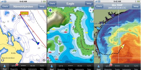
Make that pleasantly surprised! This means that iNavX users have easy access to an amazing amount of cartography (or at least it looks easy, I’m getting set up to try X-Traverse myself now). I’ve already seen how good Navionics charts look on the iPhone, and below are samples of Swedish charts, Trakmaps Canadian lakes, and Hilton sea temps. The X-Traverse service also means that in most cases this same cartography can be used with a subscriber’s MacENC or FugawiENC charting program, which can also share routes and tracks with iNavX. (The significant exception is the Navionics data, which can only be downloaded to the iPhone, as Navionics distinguishes its Mobile chart products from the cards that can be used with computer programs and MFDs.)
The apparent success X-Traverse is having with map providers also suggests that it has developed very secure ways to protect their data even while serving it to multiple platforms. This bodes well. I hope to see lots more cartography available on X-Traverse, and understand that it’s also open to other charting developers (even though it’s part of Fugawi and GPSNavX is a founding developer). Here’s wishing that companies like Navimatics, Rosepoint, Jeppesen, NavSim, etc. will at least consider becoming X-Traverse allies, or develop competitive services. My iPod Touch has shown me me how easy it can be (irritating exceptions aside) to have important chunks of the content I regularly use on my PC also available in my pocket, and I like it.


I am not sure what this charting feature will cost to use. But I am a huge fan of the PDA format for use in the cockpit.
A few years ago I got the Garmin PDA iQue which used their Blue Charts and the display is killer. It’s not a full on nav software, but the utility of having a little very viewable chart showing your position, heading, speed and course in the palm of your hand turns out to be the best think since sliced bread.
I have been a strong advocate of this type of e charting in the cockpit. You can also use it ashore for streets and POI and so forth.
I welcome this if it’s going to be a reasonable cost. I have gone back to basic cell phone service because as cool as all the features are I simply wasn’t using them. I found the small format for web use a PITA. But knowing how the charting works, this is something to watch.
I use gpsnavx on my iphone and love it
http://www.inavx.net/
A word of warning: Navionics vector charts for the iPhone are available both through the iTunes app store and X-Traverse. If you are interested in using them with Rich’s excellent iNavX2 navigation software I strongly recommend you purchase them via X-Traverse, as there seems to be some question whether the Navionics charts purchased on iTunes are usable with iNavX2. I have a question into Navionic Mobile about this now and am awaiting a response. I purchased a copy of their Gold USA East charts via iTunes a few months back and now my worry is that I will have to buy the $49 set of charts again, through X-Traverse, to get them living happily with iNavX2. I think Navionics produces a fine product, but this seems to be a pretty confusing distribution model if you ask me.
This is pure speculation, but I suspect there are strong incentives for cartographers to distribute their iPhone products via models other than the iTunes store. Apple takes a full 30% off the top of each unit sold in their store. Again, this is pure speculation, but if there are more profits to be had distributing through X-Traverse, Navionics isn’t passing the benefit on to the consumer, as their equivalent product is $49 in both marketplaces. Plus we, the end consumer, pay an additional annual $10 charge to use the X-Traverse service.
We are very pleased to have teamed up with Fugawi X-Traverse. From the beginning (long before iNavX) we have believed that charts and maps should not be bundled with applications, but instead be independently downloadable. A user should be able to choose which charts and maps they want (from various producers) and be able to get new editions of a chart or a map without requiring an entire new version of the application. NOAA is also in agreement with this chart distribution model with their RNC server online. Over the next weeks there will be more charts and maps available on x-traverse that will work with iNavX for iPhone/iPod, Fugawi for Windows and MacENC for Mac.
I consider it a serious flaw in iNavX that there is no way to install any other charts except for the ones it can download. I live in Canada and have purchased Canadian BSB charts that I would like to use but cannot. This equally applies to anyone living anywhere outside of the USA and Sweden.
Furthermore, if in the future other areas such as mine are added, it would require subscribing to a service and paying again for charts that I already own.
In my opinion the major benefit of using software on standard platforms (PC, Mac, iTouch), rather than proprietary systems like chartplotters, is flexibility. Unfortunately such flexibility is sadly lacking in iNavX today.
The new business models for delivering chart data are primarily driven by the chart providers. While it is unfortunate that the era of “free charts” is ending, it is a fact of life that in order to create, maintain and distribute charts providers must spend money. That money comes from selling charts. Having said that, having charts created in a format that “one size fits all” would be nice and as the design and distribution schemes out there are refined maybe that will become a possibility in the future.
In the meantime, Nav SW providers will continue to create apps that run the data that providers sell within the confines set by those providers. iNavX is in the enviable position of being the first to successfully create a real, full function navigation app that runs on the iPhone. They’ve also done a fine job of providing the means to load the iPhone with state of the art data from world-wide sources (including Canada, BTW) and continue to integrate additional data sources as they become available.
In a nutshell, any “in-flexibility” you see in iNavX (or any other app) isn’t the developer’s issue but rather the data provider’s issue.
Disclamer- I am not affiliated with iNavX, I just use the SW. :>)
Most chart producers would take issue with us if we circumvented their end user license agreements and allowed their charts to be installed on iNavX without their required consideration. We do wish the rest of the world would follow NOAA’s lead and offer charts at no additional cost.
I don’t see the logic here. I have Canadian BSB charts that I have purchased, and I can install them into any of the navigation programs such as MacENC, Fugawi, OziExplorer, and many others, including OziCE which runs on handheld devices.
What is the difference with the iPhone/iTouch? What makes it so special that would make it a violation of user license.
iNavX looks like a great program and I would like to use it but without the ability to use my Canadian charts it is useless to me.
Unfortunately, it’s “business logic”.
Some info on the limitations to which users of charts supplied by Fisheries and Oceans Canada are subject to can be found here…
http://www.charts.gc.ca/help-aide/faq-eng.asp#cq8
Pertinent to this discussion are the questions, “What is the time period of a CHS License” and “How many computers or devices can I use my digital charts on”
While any chart delivery service is an improvement, it is fairly doubtful that access to X-Traverse will be granted to other chart software producers. The business model is obviously to hold charts “close” and tie users to a service. There is a circular dependency here – more money is made by selling charts and more money is made by selling products that can use those charts. Fugawi and MacENC are a fit, of course – they have non-intersecting markets of Windows and Mac users. The “price of admission” for any other product would have to compensate one or the other for loss of market, and that just does not make business sense.
There is a reason the service is designed as a proprietary platform, rather than open standard based.
I think you should take Navionics disclaimer quite seriously! ” All charts and maps are for reference purposes only” actually I find the iphone/navionics
combination dangerous and highly inaccurate.
All charts purchased (other then Navionics) at X-Traverse can be used on GPSNavX/MacENC, and Fugawi in addition to iNavX. Navionics limits the charts to iNavX use.
Any Navionics charts discrepancies should be reported directly to Navionics. I have found the iPhone GPS receiver to be very accurate, but one should always check the HPE (Horizontal Position Error) in iNavX to insure a valid position is received.
“I think you should take Navionics disclaimer quite seriously! ” All charts and maps are for reference purposes only” actually I find the iphone/navionics
combination dangerous and highly inaccurate.”
Wow….that’s saying a lot…..can you cite some specifics regarding inaccuracy?
CHS charts of Canada are now available from x-traverse.com – they are the official CHS charts, and are updated frequently. Updates are free of charge during the subscription period (1 year). Charts remain on the device (PC, Mac or iPhone after the year is up, however one cannot re-download charts or get updates after the year without re-subscribing.)
Also, now avaiable are NV.Digital charts of the Caribbean and Northern Europe (Baltic Sea, German Inland Waters).
All of these charts come with two activations for use in any two X-Traverse supported devices – iNavX, Fugawi Marine ENC, Fugawi Global Navigator, MacENC or GPSNavX.
The X-Traverse Team
http://www.x-traverse.com
Navionics charts of Canada are now available from x-traverse.com. The “super” 2XG region is just $29.95 for iPhone. This region covers all Canadian waters including the US Pacific Northwest and South East Alaska.