
Helping Heloise, to preserve digital charts
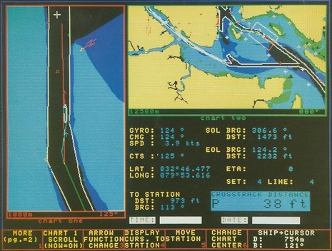
This, friends, is a screen shot from a circa 1980’s Offshore Systems PINS 9000 digital chart system. And it’s a rare image indeed. One of the odd things about the fast moving world of electronic charting is how ephemeral it is. To get the best historical sense of what early digital chart plotting was like you really need the hardware powered up on a moving vessel, or at least connected to some simulated inputs. But the truth is that even decent photographs and/or screen shots of early plotters are hard to find. That’s the problem Dr. Heloise Finch-Boyer of the UK National Maritime Museum has run into, and I’m hoping that some Panbo readers can help her…
Dr. Finch-Boyer’s current project is “a comprehensive history of the development of electronic charts”, which will be accompanied by advice to the museum about “whether it should collect digital charts and if so, what”. This is important work, I think, and I’m hoping it will lead to a full embrace of electronic chart history by the museum. In my experience — which you can sense in Panbo’s history section — nobody on this continent is paying much attention to marine electronics history in general, but the island nation of England has navigation much closer to its historical heart. The National Marine Museum where Heloise works, for instance, includes the Royal Observatory, better known as the home of Greenwich Mean Time and the Prime
Meridian. Standing there at 0� Longitude, which I did myself 17 years ago (on my honeymoon!), is nearly guaranteed to move anyone who’s explored celestial navigation and/or how the heck the wonderful graphic database we call charts evolved.
At any rate, what Heloise needs to complete her project is images of electronic chart products since their beginning in the 1970’s right up through the 1990’s. I’m guessing that some of you are working in offices where such images can be found in old advertising and product development files, be they paper or digital. Or have them tucked away at home because you too are fascinated by this stuff. Please take some time to search around, scan or photograph as needed, and email the results to “HFinch-Boyer at nmm.ac.uk“. Please copy me too (ben.ellison at panbo.com), and I’ll put up a gallery of images here. But wouldn’t it be sweet to maybe visit Greenwich one day and see the technology you’ve been part of presented in a historical context?
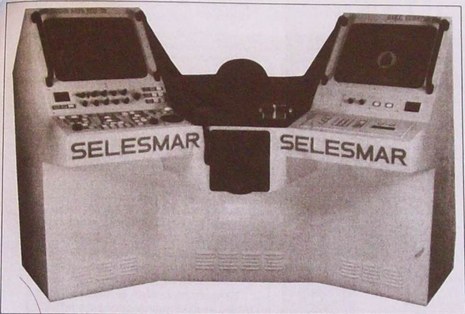
PS. The image below — a “Selesmar Scorpio 164″ from about 1992 — is one of the few that Heloise has been able to collect so far, as is the top image. You guys can do better, right?


I also hope that marine electronics companies with “obsolete” plotters and other gear gathering dust somewhere will consider getting them functional so the technology they attained can be documented. I’m as guilty as anyone about focusing almost exclusively on what’s new and what the future may bring — maybe worse than most! — but I still think we’ll regret it if we let this history slip away.
Ham Radio is an axample where the history has been preserved including the equipment, some of which is still operable.
It will be interesting to compare the charts of the electronic era. Perhaps we will see how the GPS enabled fancy 3D, color, Google Earth connected, chromed, real time, carry it on your iPhone charts are derived from really old paper charts.
I hope some of the original equipment makes it to the museum.
I think it would be helpful to be able to view an online catalogue of what images have already been collected, differentiating screen shots from equipment images. It would also help to be able to view the images themselves, even if only in low-resolution form, and/or a rating of image quality. A wish-list of images that are particularly desired might be nice, as well.
This type of information would help those of us who might be in a position to obtain such images through considerable effort (such as by the resurrecting of moth-balled hardware) to ascertain the level of need.
Thanks, Brian. I forwarded your request to Heloise, but I don’t think she’s got very much in the way of images at all. She sent me six as possible illustrations for this entry. The four I didn’t use are:
Artists impression of Disc Navigation AB (1986) (subsequently acquired by Robertson Tritech)
Transas Marine’s NS-2400 ECDIS (1997) (Photograph of working hardware)
2 screenshots of Offshore Systems ECPINS VME (1990-1999) and ECPINS-W (1998-present, currently in service with the Royal Navy)
It seems like she’s been searching more at the ship level, but I haven’t had much luck when I’ve looked for historical images of recreational level plotters. I suspect that anything you, or anyone else, can do will be a help.
Come to think of it, this Datamarine, kept alive by C-Map, is one of the few working historic plotter I know of:
https://panbo.com/archives/2005/12/the_first_chart_plotter_1985_italian.html