
My Garmin GPS 45 was amazing in 1994, and it still works (mostly)
Discovering that my old Garmin GPS 45 still works was especially nostalgic because Gizmo and I were returning from WoodenBoat School, one of the first places I used it 25 years ago. Many memories that far back are foggy, but it’s easy to recall how much this wonderful gadget helped me to stay safe and relaxed even when trying to teach beginners how to sail and navigate in big tides, cold water, and real fog.
This handheld also played an important role on many yacht deliveries and pleasure cruises, and while getting reacquainted with the old 45’s talents, I thought about how complex today’s MFD chartplotters have become, even though they’re also much better nav tools. I suspect that I’ve understood evolving marine electronics better because I started navigating before they were omnipresent — another good reason to take the WBS nav course I was assisting — and so maybe there’s value in a closer look at that transition period between paper and electronic charting.
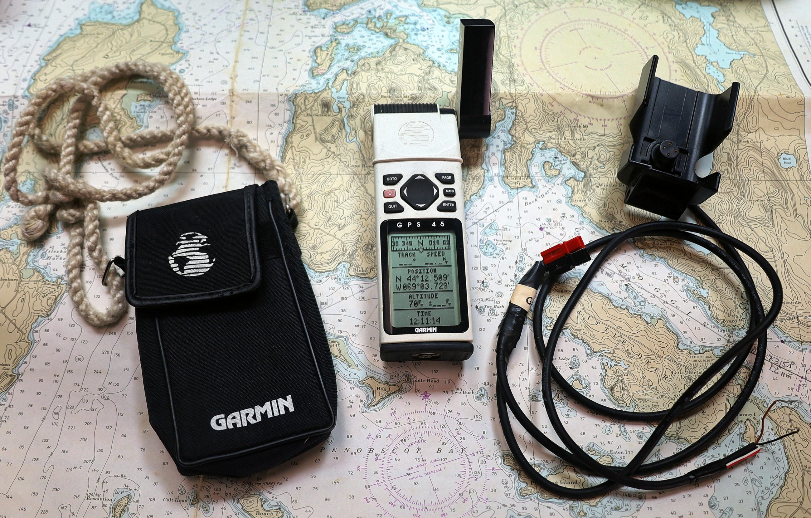
Garmin 45 with portable case and 12v mount with NMEA 0183 data wire
At some point in the early 90’s I had briefly experienced navigating with the first handheld GPS, a white brick called the Magellan Nav 1000 that “ran for a few hours on six AA batteries, and sold for $3,000” (according to this excellent early GPS history). Thus I learned early the high value of reliable electronic position finding — even at the 50-meter Selective Availability accuracy then mandated — and was quick to purchase the Garmin GPS 45 when it came out in early 1994 for about $400.
At first, and especially in open boats, that cloth case (with custom neck strap) was handy for taking a position fix — either latitude/longitude, or the bearing/distance to a waypoint — directly to a paper chart. But on bigger boats, I eventually figured out how to wire the cradle’s NMEA 0183 data port to a laptop running one of the first charting programs (Nautical Software’s ChartView, long gone but not forgotten).
So by the late 1990’s the Garmin 45 took me to the wonders of constant GPS plotting on an electronic chart, but let’s look at what it could do on its own (although I have no intention of going back).
-

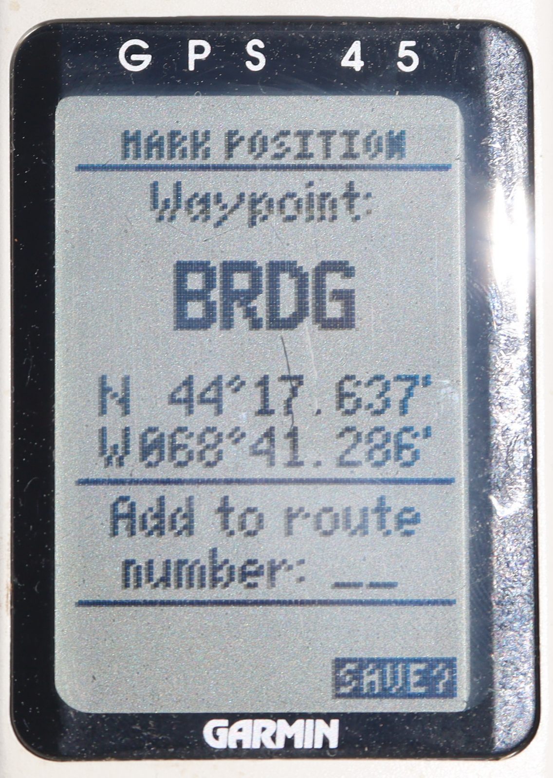
- Garmin 45 Mark Position on Deer Isle bridge
-
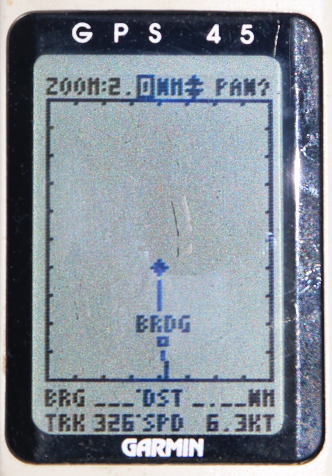
- The “Map” page would show BRG and DST to BRDG if it was active waypoint
-
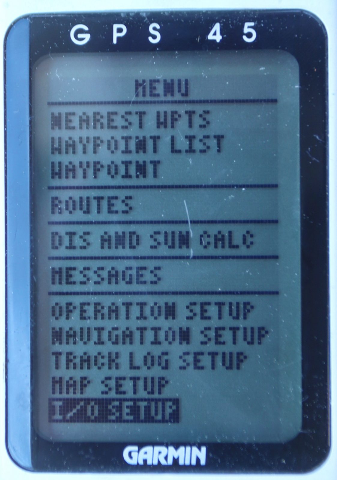
- Garmin 45 Menu page with NMEA 0183 I/O settings
The 45’s Mark button was an easy way to create a waypoint when you were actually on the spot, and that’s what I did as Gizmo passed under the (still-standing) Deer Isle Bridge. In retrospect, I should have entered a more descriptive 8-letter name, but using the 45’s up/down keys to scroll through the alphabet is tedious, and entering a lat/long position for a distant waypoint involves even more finger exercise.
Back in the day though, my fingers were busy because a waypoint set as a “Go To” with constantly updated bearing and distance was the cat’s meow. It was much easier to correlate with a chart and the real world than changing lat/long positions. Also, well-named waypoints (and past tracks) could make the Garmin 45’s otherwise minimalist Map Page quite useful.
Incidentally, in 1984 I sailed transatlantic with a Transit satnav system plotting on an electronic chart, but it was exceptionally exotic yacht gear and still only delivered fixes every two to six hours. I also used fixed Loran A and then C devices on various vessels — though I missed the “first chartplotter” — and while Loran C was quite good at returning to previously captured waypoints, it was especially dicey at calculating lat/long positions along the hilly coast of Maine. (And we’re still wasting the chance to improve it.)
In short, the inexpensive, portable, and relatively accurate Garmin GPS 45 was a true game changer. But is it really working properly 25 years later? And what does marine navigation accuracy really mean anyway?
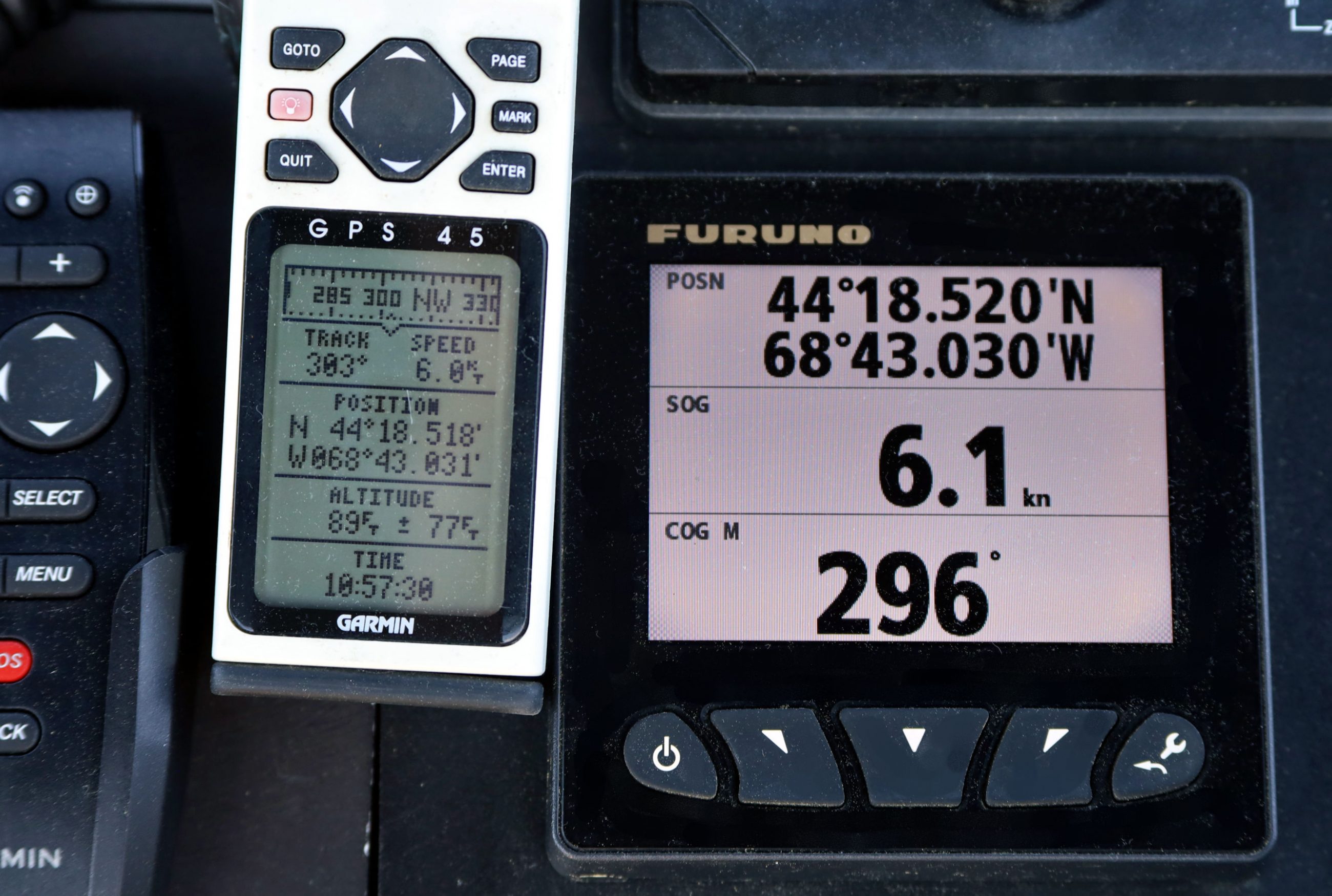
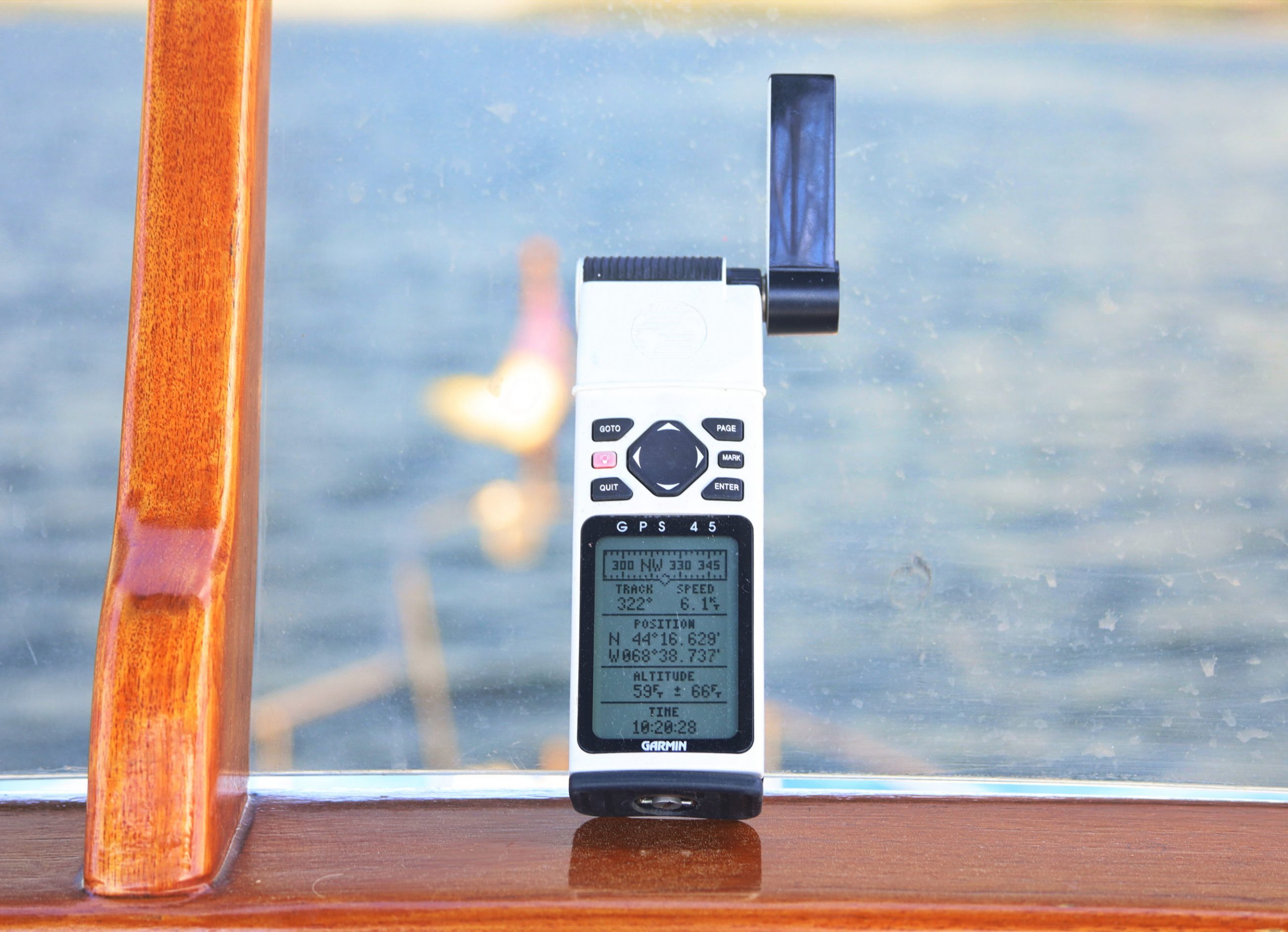
Garmin 45 working well in 2019 except that the magnetic Track (aka COG M) is consistently off
I checked the 45 against various modern GPS sources like the 56-channel receiver (with WAAS, EGNOS, and MSAS SBAS) built into Gizmo’s Furuno TZtouch2 MFD with results seen above on their FI70 display. The old Garmin’s eight channels with no Satellite Based Augmentation is consistently about this close (with a good sky view), which is darn close since the 0.002 minute of latitude difference is only 0.002 nautical mile off, or about 12 feet / 4 meters (using the 1929 international nm definition).
Also qualifying for the “Earth math we used to know” category: the 0.001 minute of longitude difference is even more accurate than it looks because 1 degree (60 minutes) of longitude at 45N equals 30nm while 60 minutes of latitude is always 60nm. And remember that errors this small are exceeded by pencil dots when using paper charts, and almost all charts are still based on old-time expectations of accuracy (see Zones of Confidence).
So be careful when you zoom deep into your precise-looking electronic vector chart. Your boat may be exactly where it’s GPS plotted, but that doesn’t mean that every dangerous object is exactly where it’s charted.
Meanwhile, the Garmin 45’s Speed Over Ground (SOG) was usually within 0.2 knots of the modern high-performance GPS competition, and they’re all better than most paddlewheel speedos then or now — let alone a taffrail log — with SOG already corrected for the set and drift we once had to guesstimate.
But the 45’s calculated Magnetic Track — now called COG (Course over Ground) — seemed to be consistently wrong by a few degrees, and the reason became obvious.
-
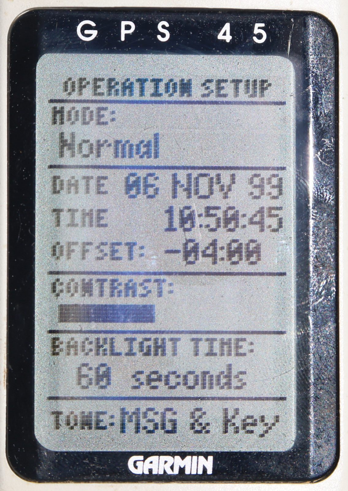
- Wrong date in 2019 could also be a magnetic variation problem?
-
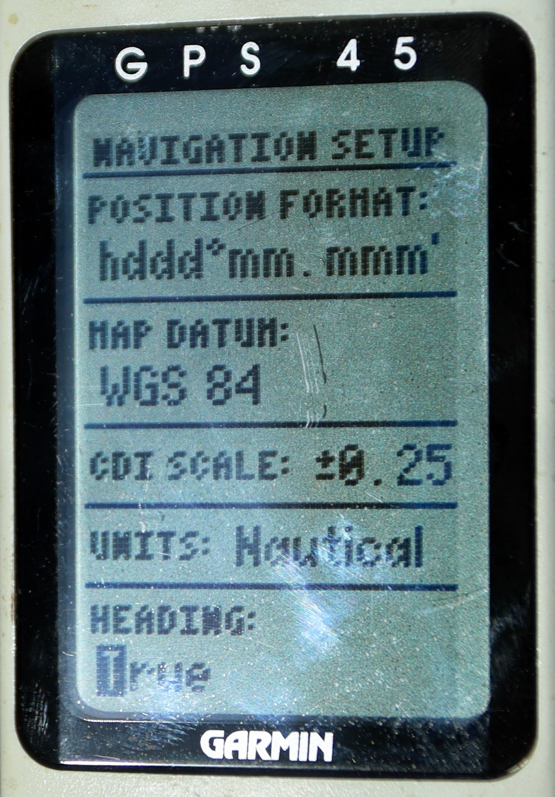
- Garmin 45 Navigation Setup changing to True
-
- BRG and TRK (COG) are true when set to True

Indeed, on June 22, 2019, the Garmin 45 thought it was my birthday in 1999 (today it reads November 22), and if you do the date math that’s exactly 1,024 weeks ago. Which is the infamous GPS date rollover number, due to an overly short data field as Ben Stein explained.
Now recall that Earth’s variable-by-region Magnetic Variation changes slowly over time, and that the World Magnetic Model is somewhere in your marine electronics. And incidentally, a manual True to Magnetic correction was part of my likely most dangerous navigation mistake, and — while the recent GPS rollover didn’t seem to cause much boating trouble — it and human error apparently did take out the NYC municipal wireless network.
At any rate, the second screen above shows how I changed the Garmin GPS 45 “Heading” type — which should read COG/BRG, not Heading, because they’re quite different, dang it — to True. Then the BRG and TRK (COG) values to the Deer Isle BRDG were correct on that final Waypoint Navigation Page that I used to value so much.
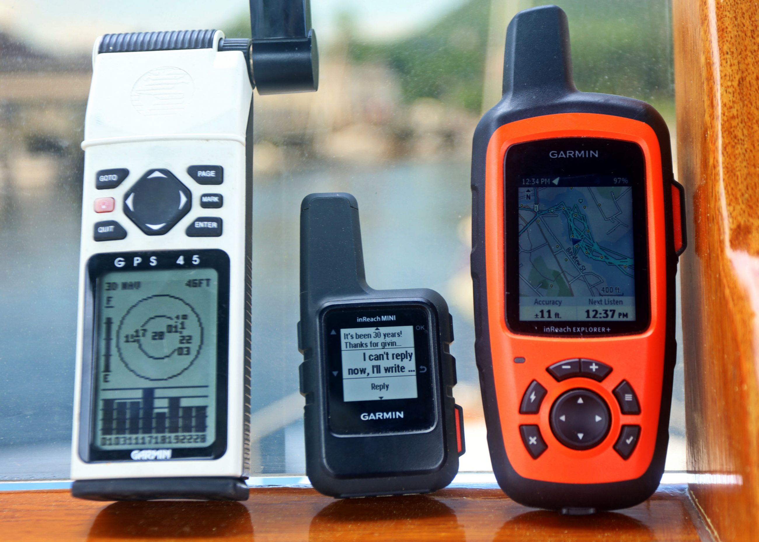
1994 Garmin 45 with latest InReach Mini and Explorer+
Finally, judging from all the Garmin GPS 45 eBay listings, mine is not the only one still working. Hat’s off to Garmin for that, but for goodness sake don’t buy one for navigation. Besides the issues already detailed, and maybe others I haven’t realized, it’s a pretty crude machine by today’s standards. The 45, for instance, can’t keep a fix at Gizmo’s lower helm though both inReachs do fine (even though their main task is two-way Iridium communications, more on Mini soon).
But I can see acquiring a GPS 45 as a key bit of electronics history, and you might appreciate the 1990’s Garmin GPS 45/40/38 FAQ — the work of many users comparing notes — and/or a visit to Retro GPS.
Speaking of retro, note the just announced Ocean Global Race that will honor the original 1973 Whitbread around the world race by doing it again without GPS and lots else. Maybe we should be taking GPS holidays on the water like some folks regularly turn off their cell phones for a day?


Fond memories, Ben! I still have our original NAV3000 on board – with optional nylon case! After much frustration with LORAN, radar out of the question on chartered boats and tiring of compass & wristwatch navigation through Maine’s rocky passages in dense fog, it was a real revelation to have a device that knew EXACTLY where it was! Initial difficulties in the Pacific NW were traced to the use of NAD29 (instead of the then-newfangled WGS84) by the Canadian charts.
Like your Garmin, the NAV3000 works fine (and still eats AA batteries at a prodigious rate) though it’s date is no longer relevant (you can enter the magnetic correction manually). It even went to Hawaii with us in 2000.
GREAT Memories Ben!!! Thanks!
We also had an old Magellan 1000 (a very good bud worked for Magellan!) . Used it in my Glasair experimental often, long before it was legal and long before anyone made GPS for aircraft.
After using my Magellan, my best bud and hanger mate bought a Garmin 45 to use in his Glasair and he loved it. One day, after we got back from one of our typical Saturday $200 hamburger runs, he set it on top of the back of my Suburban as he opened the hanger doors and we put our planes inside..
I TOLD him not to…. honest…
😉
I still have my GPS45, my first GPS. I picked it over the otherwise identical GPS 12 for the better antenna. It is explicitly a marine GPS so it still does what I need to find the racing mark in the haze and compensate for current set. It got an upgrade in 2000 when Carter removed Selective Availability from the civilian channel.
still have mine….never asked it to do much more than help me get on a reef for scuba down in the Keys..more so to mark way points …the nights before a dive trip I’d lay the old paper charts out on the table, enter points in the the garmin and avoid the brown (run aground) areas..once we were even close to most of those reefs, you started to see bouys for tie-off so 12 ft or 50 feet didn’t really matter that much to us…. Was and still is a solid tool and for those rare times I might want some GPS help, I’d still just pull it into service and head out to the blue
Hello I am looking for data cable for retro chartplotter Magellan 1200
Since you mention the Ocean Global Race, I raise my glass to Marvin Creamer, the zero-instrument circumnavigator who passed away in 2020.
My glass too!
Margalit Fox at the NYT wrote a wonderful obit:
https://www.nytimes.com/2020/08/17/sports/sailing/marvin-creamer-a-mariner-who-sailed-like-the-ancients-dies-at-104.html
My 45 was excellent for 15 plus years , hard wired for power with the plug in the back. sold the boat but kept the 45. Three years later will power up but very faint and won’t go to stored waypoints. Read somewhere there is a internal type battery that saves when there is no power?
The 45 has an internal capacitor, not a battery, for keeping the volatile data stored. Which is good, because a battery would long have leaked and destroyed the unit from the inside – the capacitor simply charges back up and works.
By “faint” you mean the display contrast? Maybe that can be corrected with the slider on the setup page?
I got two 45’ers off Ebay last year out of curiosity (and because they were much cheaper than the GPS12 I was looking for), one is working excellently and sometimes even manages to get a fix indoors. The other was working fine as well (and even had sailing trips tracklogs stored from the previous owner), but I stupidly did a master reset on it and now it doesn’t acquire satellites anymore (even after several days) – it’s probably missing the correct crystal drift compensation data now.
I tried mine (GPS45) in 2019 and it seemed to work great. Got a location easily. Took 20-30 minutes but of course it’s 1 channel.
Just tried it today… No go. It will not obtain a fix at all. Everything seems to be working fine otherwise.
I remember Garmin had a download to initialize via computer link for the y2k bug. I never needed it, but now it might come in handy. But I can’t find it.
Anyone else have any feedback on whether their GPS45 is still working or not? I suspect some other rollover, 2020 or 2022?
I know that Furuno just had a rollover event in their GPS models, and some of them will have dates in the distant past showing now. I have no idea if Garmin is similarly affected. Foruno’s fix for the location failure is a cold start, but some models either need a firmware update or they’ll never work right again as far as the date (!)
I did a bit of searching, and found that the GPS45 apparently has an “undocumented interface command” that will clear the almanac table and allow the unit to rebuild. The article I found didn’t say what it was, but maybe someone here knows?
Thanks, Hartley, and interesting that Furuno rollovers have unusual dates, with latest just last Sunday:
https://www.furuno.co.jp/en/news/notice/notice_category.html?itemid=753&dispmid=965
I discovered that Garmin says just to hold the “Light’ button for 15 seconds, which will turn it off. Then press the “Light” button for 1 second and it will wake up reset. YMMV, I don’t have one to play with 🙂
I think I’ll pull out my NAV3000 (and invest in a handful of AA batteries) when I’m back aboard and see how it is faring these days.
Aw, shucks – never mind, thats for a Garmin FORERUNNER 45 🙁
I did find a post that said you could reset it by holding the “Page” button while turning it on – not sure, but at least it wasn’t a Forerunner!
according to Garmin’s statement on the rollover in 2019, only date would be impacted, not the ability to get a fix: https://support.garmin.com/en-US/?faq=zWQY6Z2kFiAuY9kDnDBgZ6
it is sadly time to thank the 45 for the 25-ish years it gave you and move on.
Sorry, Scott, I’ve apparently misplaced my GPS45, can’t help you with software update, and don’t know about the “undocumented command” Hartley found reference to. But maybe you could try the cold start or reinitialization routine I think is somewhere in the menus?
I was concerned that a cold start would remove the various firmware updates installed over time, which are now unavailable.
I think it just means to reload almanac data from the satellites, and that firmware updates can’t be rolled back.
Yesterday I let it run for over an hour, trying to get a location via normal mode and then Autolocate mode. It would get a solid bar for a satellite, then it would gp away. Etc.
Today I did a cold start. Got a 3D fix after 20 minutes. Time is correct. But date is way off. It thinks it’s May 24 2002. I can live with that.
Funny that everything worked fine up through 2019, even correct date.
The GPS Week rollover was April 6th, 2019. Unless the internal firmware is patched, the offset date will be August 21st 1999 plus however many days its been since 4/6/2019 🙂 And in 1004 weeks or so, it will do it again!
Back in 2019, I believe September, I got a fix easily AND the date was correct, which surprised me. I guess those days are over.
I have two gps45s that have been sitting on the shelf for years. Turning them on a few days ago, one had lost all stored data and was showing the wrong date (rollover issue) while the other was ok. I was able to copy the almanac from the second unit to the first, and that fixed the date issue.
I’m writing a college paper about the evolution of GPS interfaces and I can’t thank you enough for sharing pictures of your GPS 45 working!
Doe anyone do repairs on GPS 45’s ? Have . One needs a battery and the other cames apart due to old batteries.
I just put batteries in my ancient GPS 45XL, and all is working except the date, which shows as 02 Mar 2005, and the coordinates are out by +/- 0.3 deg. – maybe because the data files didn’t update properly. I can’t find any way to reset the date etc. so if anyone sees this and can comment, thanks in advance! I have many newer Garmin GPS, and all work well.
Sorry, Jon, I don’t think that you can adjust the date or update the 45XL to correct for 1,024 week rollover error. Also, you will likely see errors in calculated magnetic bearings because local Variation values vary over time. But then again you have a partially working piece of marine electronics history!
Just took out my GPS45.
Location was good. Date same as yours.
Lost all my stored stuff how to get it back