
Mobile navigation app roundup
Apps running on tablets and phones have come a long way from the first, relatively primitive charting apps that debuted shortly after the turn of the millennia. Not only have the existing apps gained big functionality, but we’ve also seen many new entries into the category. This entry will attempt to review the currently available apps and their capabilities.
I recently posted an editor’s blog asking if tablets are ready to take over primary navigation duties. In a rewarding development for me, the post spawned a lively conversation. I don’t think there was a clear consensus from reader comments and I don’t have a definite answer to offer either.
The number of choices of mobile navigation offerings has greatly expanded. As I sat down to work on this roundup, I quickly counted a dozen options. To try and collect as accurate information as possible, I asked the developers of each app to provide information on their apps’ features and capabilities.
I’ll get to a comparison of those capabilities in a moment. But first, let’s take a look at the participants:
The apps
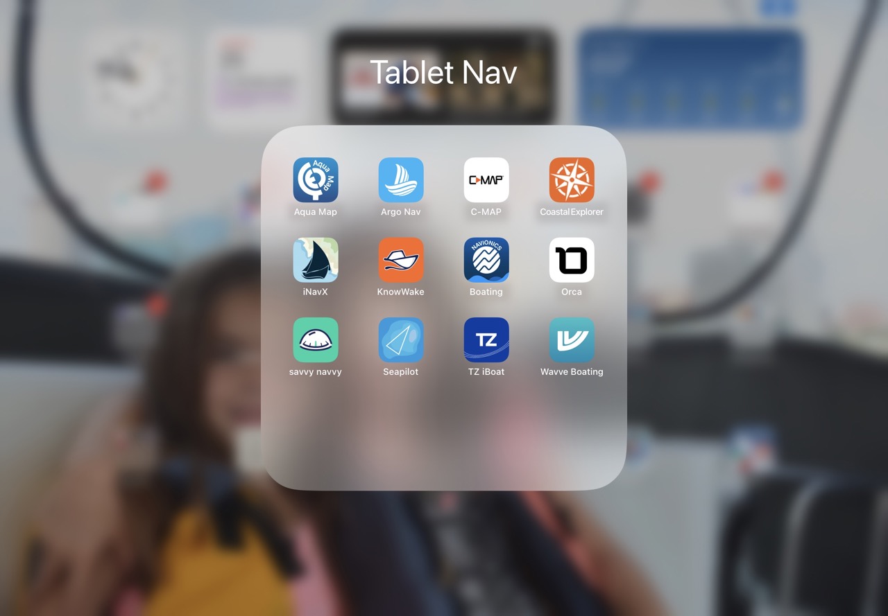
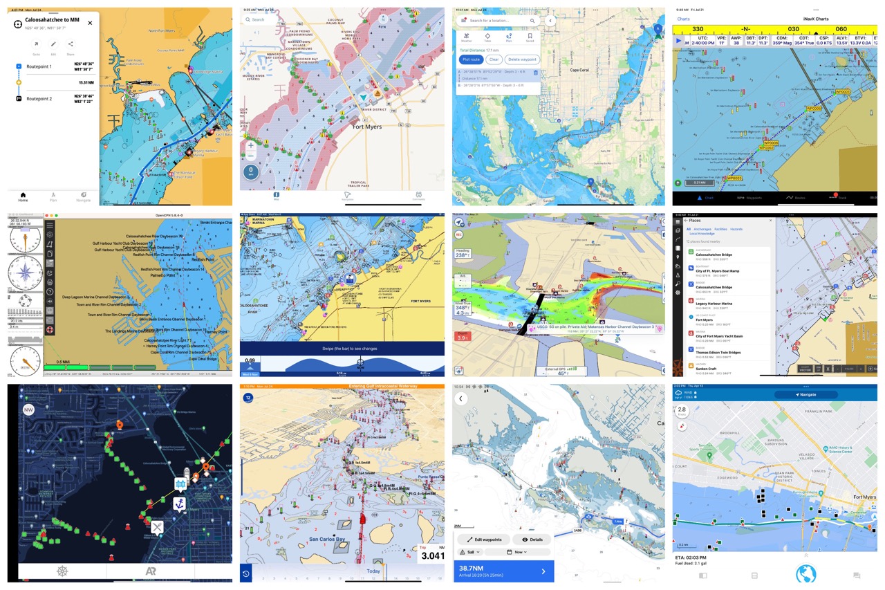
Here is a quick look at each app. Several of these have been covered previously on Panbo, but quite a few are making their Panbo debut.
Aqua Map
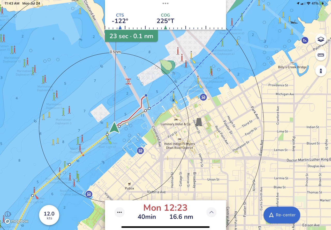
Regular readers of Panbo will no doubt have figured out that I’m a user and fan of Aqua Map. The app’s unique blend of ICW cruising tools makes it an invaluable tool for U.S.-based boaters who find themselves in that somewhat unique waterway.
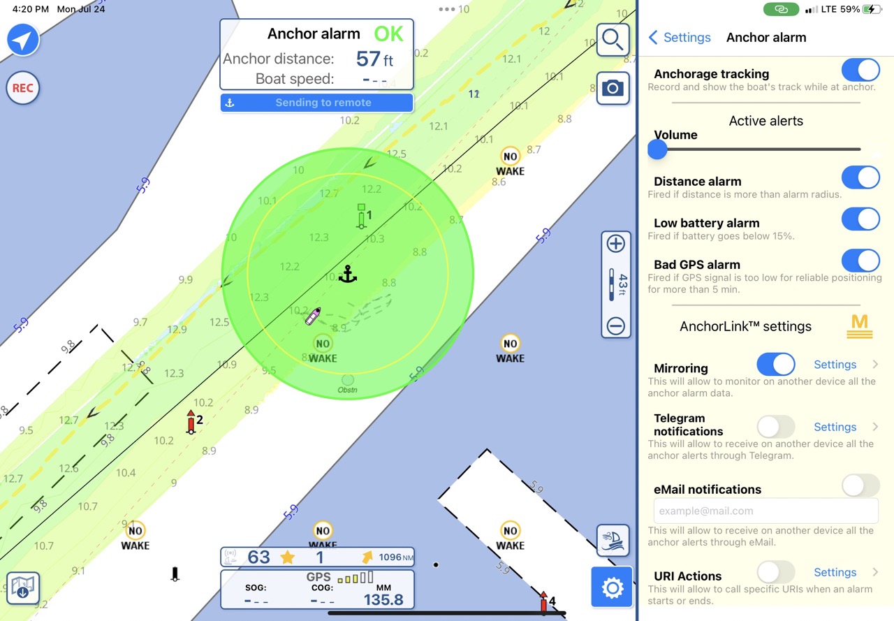
But, Aqua Map isn’t just about cruising the ICW. With support for multiple crowdsourced data, one of the most advanced anchor alarms out there, rich social features, and more, it’s a good fit for many boaters. The screenshot above shows Aqua Map’s new anchor alarm including remote monitoring and notification of the anchor alarm.
Argo
Argo is a relative newcomer, but they’ve come on strong. Argo is one of several more recently launched apps with automatic routing. To my eye, that’s a big bite for an app’s early features but so far, the routes Argo generates look pretty good. One of Argo’s unique auto-routing features is the ability to select a preference for running inside via inland waterways or outside via open water.
Argo has emphasized putting information at the boater’s fingertips. They offer a robust search that includes the ability to search marinas by amenities, a tight integration with Snag-A-Slip to streamline the process of booking and strong social features. The social features include the ability to find each other on the water, add boaters as friends, and find boaters by yacht or boating club affiliations.
C-Map
C-Map’s app verges on a companion app for Navico brand MFDs. But, with auto routing built-in, a decent anchor alarm, trip logging, and other features, it earned a spot in the roundup. The app uses the same visually appealling and, in my experience, accurate X-series charts as Simrad’s NSX and B&G’s Zeus S.
Overall, I found the app easy to use but not as fully featured as some of the more complete chart plotter replacement apps.
Coastal Explorer
Panbo’s relationship with the PC version of Coastal Explorer dates back to Ben Ellison’s 2005 coverage of its public beta. Shortly after I bought my first Great Lakes boat, I bought Coastal Explorer, mostly because of Ben E’s coverage and positive reviews. While CE remains an excellent navigation package, many helms don’t lend themselves to a full-fledged PC. So, Rosepoint Navigation has developed Coastal Explorer for Android and iOS.
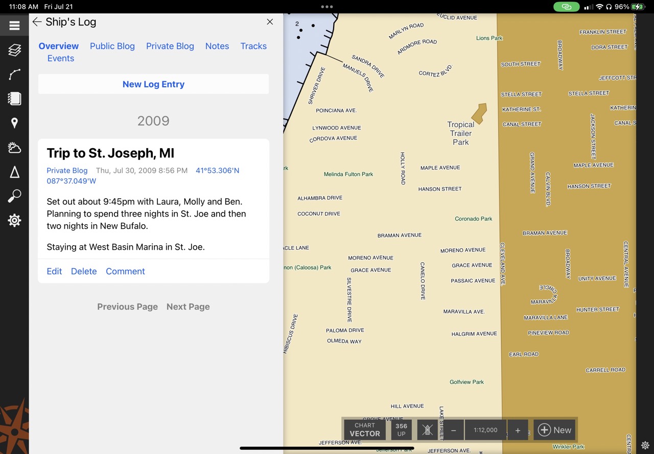
Like CE for the PC, the mobile version is a powerful and fully featured navigation package. It also has the advantage of syncing up with Coastal Explorer for the PC. So, shortly after logging in to my account, I was treated to my log entry from a 2009 trip across Lake Michigan.
i-Boating
8/3/2023 – added i-Boating after reader suggestions – i-Boating was added to this list after several readers suggested it be included. Those readers enthusiastically endorsed both the capabilities and customization of the app. I’m planning on spending more time on the water with i-Boating, but thus far I’m impressed with the broad feature support of the app.
i-Boating includes automatic routing. In my testing, automatic routes were calculated almost instantly. So fast, in fact, that I was skeptical the routes were actually calculated. But, looking through the routes, I found good routes that followed safe depth, ATONs, and avoided hazards. Thus far, I have found the learning curve on the steeper end, though the app is also very fully featured which follows a pattern of other apps in this roundup.
iNavX
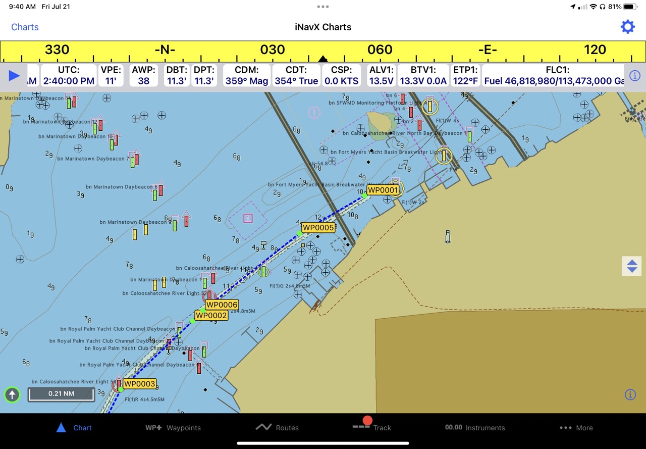
iNavX is the grandfather to many of the apps in this roundup. Putting this entry together has taken me way back in the Panbo archives. Ben E first posted about iNavX in 2008 when it hit the nascent App Store just weeks after the release of the iPhone 3G. If you have a moment, the comments on that 15-year-old article are a fun read.
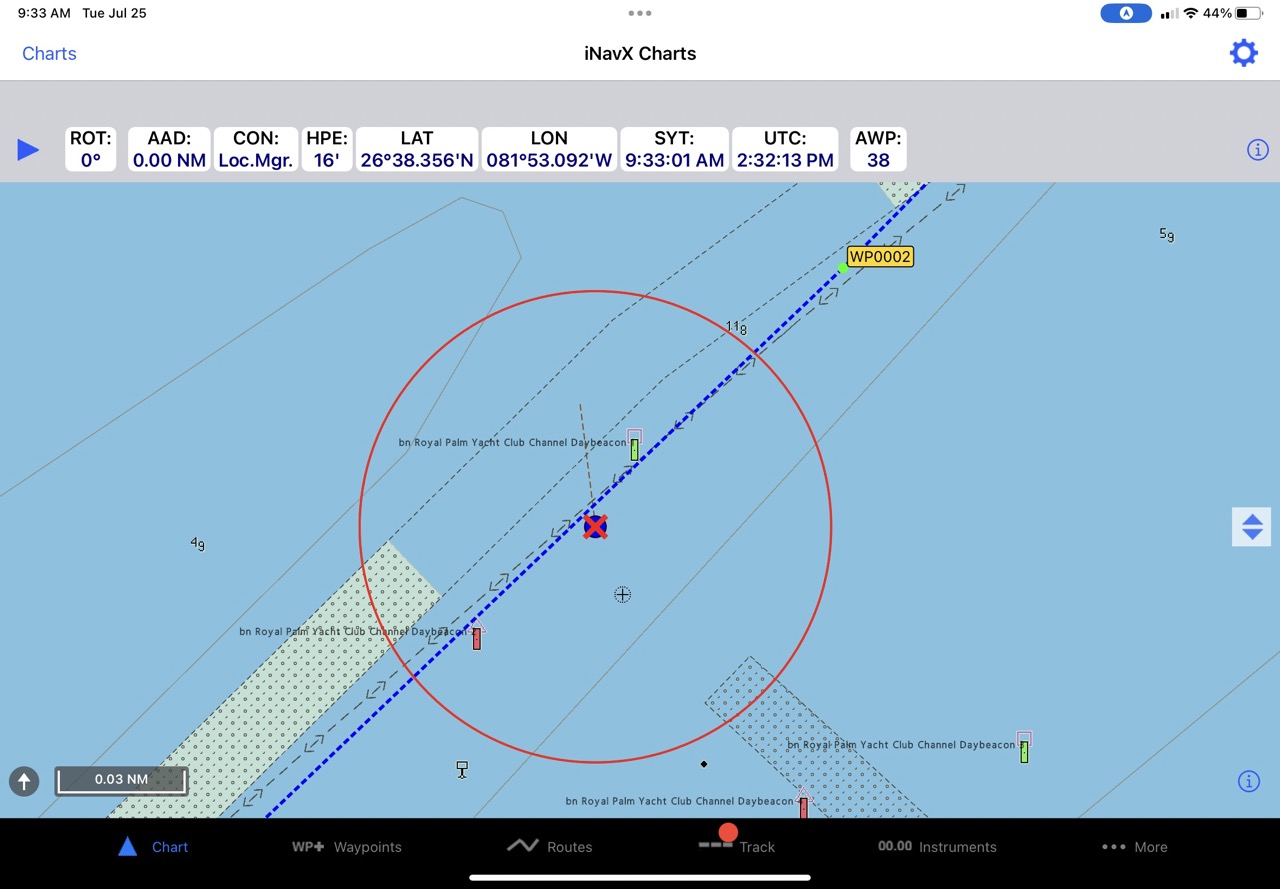
Since its launch, iNavX has built out its feature set to include integration with onboard electronics, weather display, anchor alarm, and a comprehensive chart catalog. iNavX has recently replaced the increasingly difficult-to-license Navionics and C-Map data with their own iNavX Professional+ charts. The interface isn’t as intuitive as some of the more recent apps, but it has a mature and complete set of features.
KnowWake
KnowWake promises to be the Waze of boating navigation apps. That aim means the app focuses on ease of use and reporting things seen on the water. Ease of use comes from a relatively simple interface with automatic routing, color-coded no-wake zone indications, and strong social capabilities.
The Waze-style reporting of points of interest along the water allows boaters to share information with other boaters about hazards, interesting sites, and even law enforcement.
Navionics Boating
Navionics’ Boating app has, to me, long represented the navigation app with the shortest learning curve. I find the app intuitive and easy to use. It includes Navionics’ auto-routing capabilities, Active Captain Community data, Sonar Charts, and more.
Starting at $25 per year, I think it’s a no-brainer for the power of the app and comprehensive charts. Perhaps the biggest potential downside is the likelihood that an onboard chart plotter is already using Navionics’ charts. That means the app isn’t providing redundancy in the event of a charting error in Navionics’ data.
OpenCPN
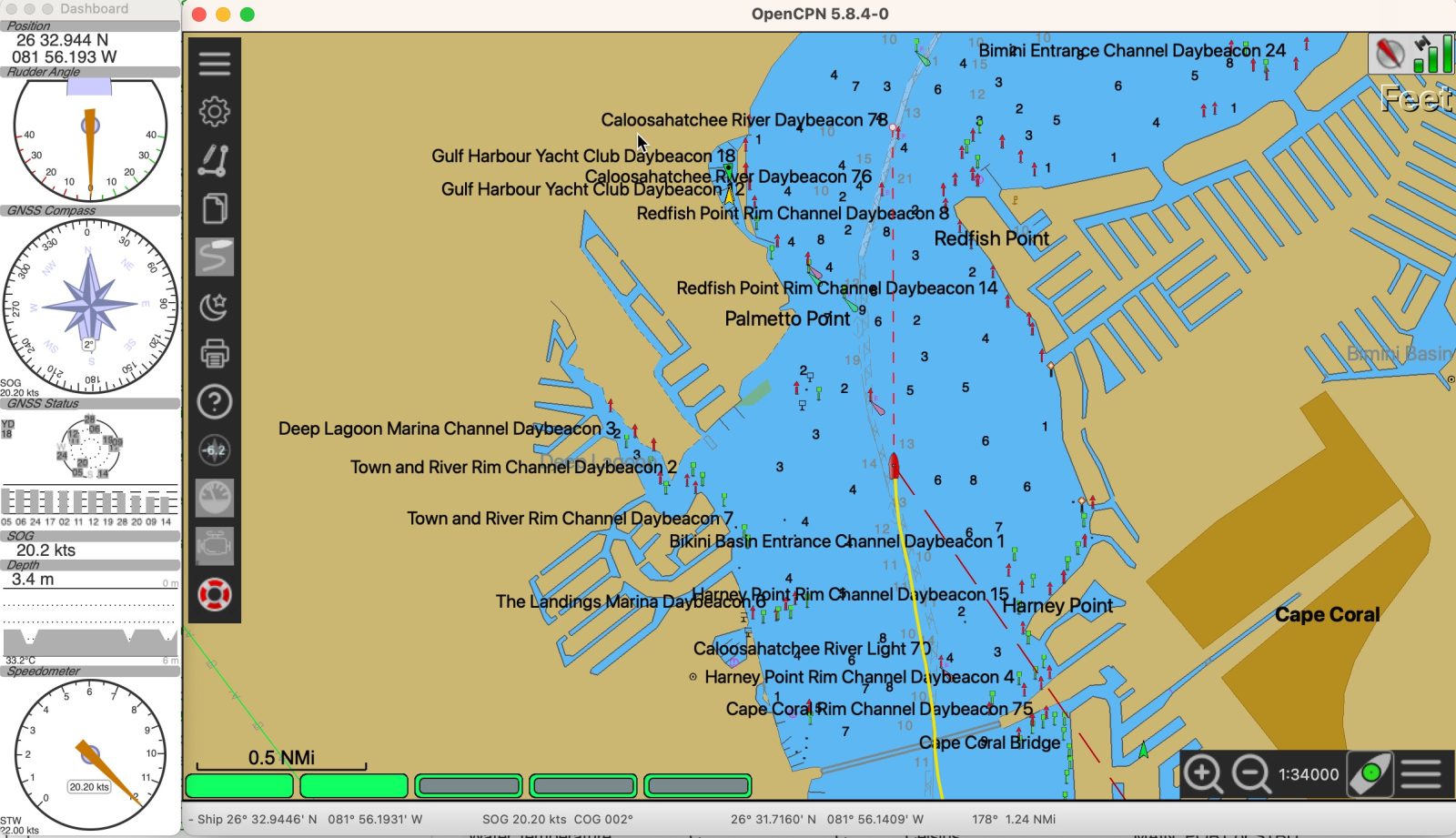
OpenCPN is a little bit different than any of the other apps discussed in this review. First, it’s an entirely free, open-source project. The app is free, charts are free, and there are no advertisements in the app. Second, OpenCPN runs on Windows, MacOS, Android, and numerous flavors of Unix/Linux including on a Raspberry Pi. But, it doesn’t run on iOS and that’s limiting for many users.
OpenCPN is the most customizable of any of the apps discussed and includes a deep plug-in catalog. That catalog includes radar support, engine gauges, and many other options. OpenCPN’s customization comes with a need for a little bit greater user investment. I think the learning curve is a bit steeper than many of the other apps.
Orca
Orca’s system is comprised of both software and hardware. But, the app can run on any Android or iOS tablet without any of their hardware required. As I mention in my recently completed, in-depth review of Orca, they offer a lot of capabilities. With all that it can do, Orca is making a serious run at replacing traditional installed equipment.
The system includes extensive sailing features, autopilot integration, coming radar support, as well as a full feed of NMEA 2000-based gauge capabilities. To take advantage of all their features, an Orca Core is required, but their automatic routing and core navigation features can be used on any GPS-equipped Android or iOS tablet.
Savvy Navvy
Savvy Navvy is a visually appealing, intuitive app to use. I find it nearly the equal to Navionics Boating for ease of use. Savvy Navvy’s auto-routing will factor in a sailboat’s polars, avoid traffic separation schemes, and respect ATONs. As a relative newcomer, that’s an impressive set of features.
The app’s intuitive UI make getting started with it quite easy. I quickly found myself comfortable with the app and utilizing its features. I found the core navigation features to be quite strong but support for external GPS, Depth, AIS, and other instruments is currently lacking. They are working on adding internet AIS aggregator support and hopefully will add some of the features soon.
SEAiq
SEAiq is available in two versions, SEAiq and SEAiq Pilot with advanced features aimed at professional mariners. In fact, SEAiq says that one-third of professional pilots worldwide use the pilot version. I added SEAiq after a hearty endorsement in the comments, so I’m a little new to it.
Thus far, it looks very capable and is one of only three apps in the roundup capable of displaying engine data. I have found the learning curve a little steep but once I’ve gotten things figured out, I’m impressed by the power of its functionality.
Sea Pilot
Sea Pilot debuted in 2011 and was acquired by Raymarine in 2018. The app offers auto-routing, WiFi instruments, and AIS data, internet AIS aggregated data, and more. Sea Pilot’s auto routing will consider a sailboat’s polars and weather conditions, but in my testing I had a hard time getting automatic routes created in the shallow waters of southwest Florida.
Sea Pilot’s NMEA integration, AIS capabilities, and professional chart appearance make for a capable navigation system. Like some of the other apps that have been around for a while, the interface isn’t as visually appealing as some of the new apps.
TZ iBoat
TZ iBoat is a full-featured navigation package in its own right. But, iBoat also integrates tightly with Furuno equipment. That integration includes support for Furuno’s DRS4W WiFi radar, autopilot support, and participation in the TZ Cloud. TZ Cloud integration allows seamless synchronization of routes, trips, waypoints, and more across TZ devices including PCs, mobile devices running TZ iBoat, and Furuno NavNet TZ Touch 2 and TZ Touch 3 MFDs.
TZ iBoat also includes a robust weather forecast display system, anchor alarm, and all the features you’d expect of a navigation app. The main limitation is iBoat is only available on iOS; there is no Android version.
Wavve Boating
Wavve Boating‘s tagline is, “A better boating experience with the easiest marine navigation app.” To ensure ease of use, Wavve has focused on keeping the user interface simple. The focus of the app seems to be ease and simplicity, auto routing, and social features.

Like several other apps in this roundup, Wavve says they’re trying to deliver an experience like Google Maps or Waze. So, like Waze, Wavve Boating allows a user to report various types of information and sites encountered on the water.
General features
Let’s start with a high-level comparison of the features each app offers. Initially, we will look at the cost of each app and some of the most important features each app offers. I’m going to drill deeper into several of these features to break down some of the more subtle differences between them.
| Minimum price | Automatic routing | Integration with onboard nav electronics1 | Display internet sourced weather info | Anchor alarm | ActiveCaptain Community, Waterway Guide, or Navily | Import/Export data | |
| Aqua Map | Free for 1 chart tile at a time, $9.99 / year | ✓ | ✓ | ✓ | ✓ | GPX, KML, KMZ | |
| Argo | Free basic, $19.99 / year for premium | ✓ | ✓ | ||||
| C-Map | Free app, $14.99 premium features | ✓ | Screen mirroring Navico MFDs | ✓ | ✓ | GPX | |
| Coastal Explorer | Free app, $50 / year for charts and nav features | ✓ | ✓ | ✓ | GPX, NOB | ||
| i-Boating | Basic app is free, U.S. charts are $14.99 / year. All other licenses are perpetual | ✓ | ✓ | ✓ | ✓ | GPX, KMZ | |
| iNavX | Free app w/ NOAA charts, premium add-ons | ✓ | ✓ | ✓ | ✓ | GPX, KML, KMZ | |
| KnowWake | 100% Free | ✓ | ✓ | ✓ | ✓ | CSV | |
| Navionics | $24.99 / year for U.S. and Canada | ✓ | ✓ | ✓ | ✓ | ✓ | GPX |
| OpenCPN2 | Free except $9.99 for Android | ✓ | ✓ | ✓ | GPX | ||
| Orca | Free app, downloadable charts and premium features €119 per year | ✓ | ✓ | ✓ | ✓ | ✓ | |
| Savvy Navvy | Free baisc USA coverage, $99 /year premium, other regions- tiered offerings | ✓ | ✓ | ✓ | ✓ | GPX | |
| SEAiq | App and basic features are free. SEAiq is $50, SEAiq USA is $25 | ✓ | ✓ | ✓ | ✓ | GPX, KMZ, CSV, HTML | |
| Seapilot | Free basic, $39.99 / year premium | ✓ | ✓ | ✓ | GPX, GRB, polars as text | ||
| TZ iBoat3 | Free app, US coverage is $19.99 per year AIS and Radar add-ons | ✓ | ✓ | ✓ | TZ cloud, GPX | ||
| Wavve Boating | $7.99 / month or $45.99 / year | ✓ | ✓ |
I think it’s important not to simply count the checkmarks in the tables and use that to decide which app is best. The intent and area of focus of these apps vary. Including based on the types of boats and boaters they’re designed for, the other equipment they’re intended to support, and the cruising grounds they best support.
Integration with existing navigation electronics
The vast majority of the apps included in this roundup support receiving location and depth information via WiFi. The most common means of transmitting this data is via a device attached to the boat’s NMEA 2000 network that translates the data on the network and transmits it via WiFi. That device may be an AIS unit, an MFD (limited to Navico MFDs), a dedicated NMEA 2000 to WiFi gateway, or a gateway manufactured by the software developer as Orca and Rose Point offer.
Most apps are designed to use an NMEA 0183 formatted data stream. This detail gives rise to some confusion. Although the data comes from an NMEA 2000 network, it is formatted using NMEA 0183 sentence structure. This is seemingly a vestige of the transition from NMEA 0183 to NMEA 2000. The NMEA 0183 data structure can prove limiting for newer data types. For example, engine data and digital switching weren’t ever part of the NMEA 0183 standard. As a result, carrying this data over NMEA 0183 requires some creativity and limitations. In the near future, I expect we will see more apps move to support a raw NMEA 2000 feed rather than the translated NMEA 0183 one. In fact, Orca is already doing this with their Core.
| Location | Depth | AIS via WiFi | AIS via internet | Weather | Engine information | Autopilot | Radar | |
| Aqua Map | ✓ | ✓ | ✓ | ✓ | ||||
| Argo | ||||||||
| C-Map | ||||||||
| Coastal Explorer | ✓ | ✓ | ✓ | ✓ | ✓ | ✓ | ||
| i-Boating | ✓ | ✓ | ✓ | ✓ | ✓ | ✓ | ||
| iNavX | ✓ | ✓ | ✓ | ✓ | ✓ | ✓ | ✓ | |
| KnowWake | ✓ | |||||||
| Navionics | ✓ | ✓ | ✓ | |||||
| OpenCPN | ✓ | ✓ | ✓ | ✓ | ✓ | ✓ | ||
| Orca | ✓ | ✓ | ✓ | ✓ | ✓ | ✓ | ✓ | ✓ |
| Savvy Navvy | In progress | ✓ | ||||||
| SEAiq | ✓ | ✓ | ✓ | ✓ | ✓ | ✓ | ✓ | |
| Seapilot | ✓ | ✓ | ✓ | ✓ | ||||
| TZ iBoat | ✓ | ✓ | ✓ | ✓ | ✓ | ✓ | ||
| Wavve Boating |
Charts
Nearly every chart we use on our boats starts with a government hydrographic office (HO). From the foundation of an HO chart, developers take that data, interpret, potentially enhance and augment, and display it on their navigation apps or chart plotters. Chart publishers like Navionics and C-Map have been doing that work for decades and have rich data of their own to integrate into the HO-sourced charts. Other apps may simply take the HO charts, format them for display in their software and present the data to the user.
One of the realities of the acquisition of Navionics by Garmin and C-Map by Navico is the reduced availability of those charts to third parties. As a result, apps that formerly supported a rich catalog of Navionics, C-Map, and HO-sourced charts have fewer charting options. Additionally, nearly every navigation app or chart plotter developer is now also in the business of chart packaging.
| Chart Providers | Notes | |
| Aqua Map | Government HOs, Explorer Charts, private data sources | Aqua Map displays over 80,000 U.S. Army Corp of Engineers surveys and USCG lights list and local notices mariners. NOAA charts, USACE surveys, and USCG LNMs are updated weekly and the lights list is updated daily. Over 14,000 lakes with bathymetry in the U.S. and Canada |
| Argo | NOAA ENCs and Crowdsourced bathymetry data | NOAA ENC view presents real time chart with no lag in updating ATONs. Standard charts also depth information from over 90,000 USACE surveys |
| C-Map | C-Map, Government HO charts, Explorer Charts | C-Map charts are Disover-X and Reveal-X, C-Map’s latest chart technology. Charts include official HO data as well as unique survey data only available in C-Map. Genesis layer includes quality-controlled crowd-sourced data. |
| Coastal Explorer | Government HO | |
| i-Boating | Government HO | |
| iNavX | Government HO, Explorer Charts, iNavX Professional+ Charts, Blue Latitude, CHS, Delius Klasing | iNavX Professiona+ charts developed with SliTech. They are country-specific vector charts leveraging HO charts alongside other providers. In progress adding all inland waters of the U.S. |
| KnowWake | Government HO | Government HO, Self-updating, color-coded wake zones |
| Navionics | Government HO, private survey, user submissions from app and MFDs using Navionics charts | |
| OpenCPN | Government HO, Explorer Charts, Mbtiles from numerous sources | |
| Orca | Orca charts (sourced from Government HOs) | Automatic updates and 100% transparency on data sourcing for each country |
| Savvy Navvy | Government HO | Savvy Navvy licenses UKHO, NOAA and other official HO charts from around the globe. Their designers build Savvy charts from the ground up to show essential marine information in a clean and easy-to-view interface. Also use OpenStreetMap for land views. |
| SEAiq | Government HO | |
| Seapilot | Government HO, In Sweden – charts from Hydrographica | Charts are offered for Europe, North America, Australia and New Zealand |
| TZ iBoat | Government HO, Explorer Charts, In-house Mapmedia charts | A single subscription unlocks vector, raster, BathyVision, depth shading, continuous updates, and community maps |
| Wavve Boating | Government HO |
Crowd-sourced data
One of the traditional advantages of navigation apps is their ability to display and update crowd-sourced data including anchorages, hazards, marinas, and other points of interest along the water. In the United States, the two main providers of this data are Waterway Guide and Garmin’s Active Captain Community. In Europe, Navily seems to be leading the way.
Additionally, quite a few of the apps included in this review maintain their own database of information submitted by their users. I prefer one of the cross-app services like Waterway Guide, Active Captain, or Navily because the data isn’t limited to just users of one app.
| Waterway Guide | Active Captain Community | Navily | Notes | |
| Aqua Map | ✓ | ✓ | Aqua Map live sharing | |
| Argo | Argo Community | |||
| C-Map | C-Map Genesis Community | |||
| Coastal Explorer | ✓ | |||
| i-Boating | ||||
| iNavX | ✓ | |||
| KnowWake | ||||
| Navionics | ✓ | |||
| OpenCPN | ||||
| Orca | ✓ | |||
| Savvy Navvy | ✓ | |||
| SEAiq | ✓ | |||
| TZ iBoat | Community Maps | |||
| Wavve Boating | Wavve Boating Community |
Final thoughts
One of the single best things about mobile navigation apps is the ease with which a boater can switch between them. In your own usage, you may find you prefer one app for inland boating and another for open water. You might find you prefer the navigation of one app but the logging of another. Whatever your preference, the cost is typically low enough, and switching is simple enough that you can easily use multiple apps for whatever you like.
Another advantage of mobile apps is the ease with which they can be updated. So, often if you find your favorite app is lacking a feature, it might be just around the corner.
I encourage boaters to try as many apps as necessary to find what they like best. Experiment and get to know these apps. They have some really amazing tools and deliver those tools at a very affordable price point. Finally, if I’ve missed a comparison you’d like to see, please let me know in the comments below. Perhaps I’ve missed an app or I haven’t drilled into a detail. There are so many ways to compare these apps, I had to draw the line somewhere. But, I have more data and would be happy to address additional areas.


Ben, do you know any apps that allow the use of mbtiles or import and storage of other satellite images for offline use? I used to use Ovitalmap, but it seems it’s no longer supporting that feature. Very useful in poorly charted areas. Thanks
I know iNavX supports the use of satellite imagery, but I don’t know if it will download the images for offline consumption. I’ll send a message to the developer.
-Ben S.
OpenCPN!
qtVlm does both
Why isn’t iSailor in this list? It’s a very good app, if not the best if them all.
Also, I found some of these apps don’t allow setting waypoints by coordinates? Support for such essential features need to be made sure of imho.
Hi Nick,
I’ll reach out to the developer of iSailor and ask them to participate in the roundup.
I agree that boaters should make sure that the features they need are available in their app(s) of choice. But, it’s very difficult for me to figure out how each boater will use the app. A feature one boater considers essential may not even be used by another boater. That represents a challenge when trying to compare many different apps. I’ve tried to capture the most frequently used and requested features but can’t cover every one of them.
-Ben S.
I’m back… I just tried to reach out to iSailor to ask them for help in including them in the roundup. Unfortunately, it appears the app isn’t being updated any longer. In fact, their domain, isailor.us isn’t responding. I also found this post about the same concerns: https://forums.sailinganarchy.com/threads/isailor-should-i-be-worried.238041/.
So, it doesn’t look like they will be included. But, I did reach out to the developer of SEAiq to include them.
-Ben S.
They were hit by sanctions (iSailor comes from Transas) but moved their company to Serbia so it is back operational in the appstore for iOS only. I think you are correct that there have been no app updates because their developers are in Russia I think, but chart updates are available and in this form, even without updates, it is the best app to download on an iPad. The app simply is complete and doesn’t need bug fixes etc.
I use iSailor and have recently had an issue where a chart area wasn’t updated. This was Southampton and Portsmouth UK. I reached out tho their help and they had their chart supplier fix it within a week.
Chart updates are expensive but there is way to update all your purchased charts for free. I have over 45 installed charts and update them all for free four times per year. i have never paid more than the initial fee for any of my charts.
Im not sure of I should put the work around on here.
iSailor is still the best app out there.
Kevin, can you share the work around some way? I paid quite some money for charts with free updates, but since Wartsila bought the company the terms have changed and updates don’t download anymore. It’s a shame, as it’s still a good app.
I agree that it is impossible to test everything, but creating a waypoint by entering coordinates is something that you consider optional? I haven’t heard that before…
Nick,
I don’t think that every user of a tablet navigation system enters waypoints by manually entering lat/long. In fact, in my normal operations, I don’t find myself ever entering them manually. Hence, I didn’t test for it. If you would like to test for it and report what you find, please feel free.
-Ben S.
Okay… it works just fine on iSailor I heard rumors it doesn’t work in some popular apps but I don’t have those.
So if someone sends you coordinates for a waypoint, or you read that in a cruising guide or from an Explorer Chart to the Bahamas etc., then how do you create it?
Anyway, I’m probably too precise and old fashioned ha!
I’m not sure I’m the target to answer that question. First, I still consider any tablet navigation package a part of a larger navigation system. In my world (fair to accuse me of being biased due to my access to equipment) that includes installed equipment. So, if I must go to a specific set of coordinates, I’d probably use an MFD. But, I can also tell you those situations are, for my boating, extremely few and far between.
I do know off the top of my head that Aqua Map and Navionics both support direct entry as I’ve done it. Interesting to note that the last time I can remember doing that was in 2017 while using Robert Sherer’s (Bob423) ICW tracks. That was in the days before Aqua Map’s support of USACE surveys and before the myriad, much easier ways to import a series of waypoints. In fact, these days, except for another boater giving a set of coordinates for a meetup, I can’t see many cases where that information wouldn’t be conveyed another way. And even that meetup might be better accomplished with the social and location sharing capabilities of many of these apps.
-Ben S.
Aqua Nap allows you to enter Lat/Long to place a waypoint. It uses a graphical interface where you turn a series of wheels to enter the numbers, very fast. Optionally, you can enter the numbers directly.
The key to reliable nav info is in my opinion the accuracy and the frequency of updates of the charts.
The professionals have very strict procedures for updating their ECDIS systems. The leisure market is less strict. So for every app it must be very easy to find information on what the latest update is.
I refer to the situation on the North Sea, where offshore windparks keep sprouting up like tulip fields
Aqua Map NOAA charts are updated weekly. The ATON locations are updated daily, automatically from a digital version of the light list put out by the Coast Guard.
The US Army Corps of Engineers (USACE) survey charts are updated weekly in Aqua Map. Tapping on a chart brings up a text box with the date of the survey
Hi Ben, I believe you have short changed open cpns capabilities. I am cruising in the PT area having just come through the whole South Pacific using MB tiles with satellite views from three or four different sources of every single Island and atol. In places where cmap is severely lacking and Navionics is slightly off, the satellite views provide the only way of being sure of a given pass or Reef or even location of bommies. See the website the chart Locker for an example of all the satellite charts that are available. I have a high nit daylight display at my nav station running open CPN on a PC (and also on my android tablet. As Starling is working in more remote areas Navionics on the tablet can use the satellite fuse with more frequency and accuracy. No one is cruising using just one system anymore, everyone has satellite views and multiple charts!!
1. If AquaMap gains radar support, the traditional chartplotter market immediately switches 10% to it (that’s about $100 million of the $1 billion market). Maybe 25%. It’s important to note that AquaMap runs on Android.
2. If I were doing it all over again given today’s technology and market, changes need to be made to the social data to find ways of automatically determining data and sharing it instead of requiring manual data input. Consider how Google Maps, Waze, and Apple Maps determine traffic warnings without anyone adding it manually – it’s determined organically from people using the apps while driving. Obviously traffic isn’t very important while moving in a boat (or are there time when it is?) but there are many extrapolations of automatic data collection which haven’t been touched by boat app developers yet.
3. Why isn’t anyone playing with adding generative AI capabilities to these apps? I can think of a dozen new capabilities possible and I’m not even developing code any longer! Where are the innovators?
On your point 3: Let’s hope never: generative AI is great for problems where there is no wrong answer. Only. Navigation aint such a problem. Generative AI is really “imitation intelligence” in that there is NOTHING intelligent about what it does. It mimics, but has exactly zero understanding or knowledge.
I’d like to recommend SEAiq. It has a very good display of AIS data, I like it better for it than any other app.. Also it has good troubleshooting display of data strings coming into it. It uses Government vector charts which good. The best for me in fog!
SEAiq does not support USACE survey charts which are a must for ICW navigation.
That’s fine but great interface in fog!
Where did you here that? USACE is under “Inland Waterways” at the bottom of the “NOAA & USACE” chart section. Currently showing 107 charts.
SEAiq has been my goto for years except when forced into Expedition. It’s been quite reliable, has great chart quilting, and seems to burn less battery than other apps. It’s been easy to hook up to many N2k->0183/WiFi gateways from Navico, Vesper, and Yacht Devices.
Ooh, I see what you mean – not the base chart but the periodic depth surveys that show recent shoaling.
SEAiq has been added to the roundup. Thanks for the suggestion.
-Ben S.
A few more notes on SEAiq:
– It integrates with chart repositories, so when NOAA or other sources publish new charts you get notified to update (and it handles the update)
– It supports buying charts from many international sources (most countries aren’t enlightened like the US which makes charts available for free) but this doesn’t seem aimed at recreational mariners
-SEAiq is working w/ NOAA to integrate the newish IHO S-111 & S-104 Current & Water Level standards. NOAA publishes these for only a few regions so far.
For the real number crunchers qtVlm might be an option, very extensive weather routing capabilities, aimed at sailing boats. It takes some practice to get familiar with all the possibilities. Free for windows. Pay for android and IOS.
After recently travellig more than 1,200 miles of Western Rivers and Gulf ICW, count me solidly in the AquaMap fan category. In addition to providing a intuitive display of Army Corps of Engineers survey data for ICW, Aqua Maps also provides the same ACof E data for Western Rivers. While that is not continuous, it looks like the Corps surveys much of the Western Rivers.
I like Navionics, and the autoroute feature is useful as a very rough first pass at planning. I’ve had it suggest clearly unsuitable routes, so you absolutely have to check carefully. But, for a rough estimate of how far, and how long – the auto routing feature is useful. What I dislike about Navionics is that (unlike Aqua Map) you cannot know the age of the chart data you are looking at. No way to find that age of the base chart data, the age of the ATON data, or the age of the crowdsources SonarChart data.
Also – for my 1,200 miles plus on Western Rivers and Gulf ICW, I also used the PC version of Rosepoint Coastal Explorer. Which I came to like a lot.
It uses the NOAA charts, so you are seeing only that. But it is a very useful tool. For my trip, I used Coastal Explorer as my main AIS display – which I found helpful.
Hi Ben, thank you; that is a great and impressive write up & in depth comparison. I’ll for sure be trying a few.
Me too I love iSailor, and have my fingers crossed that somehow they resurface and continue developing their app. Though I have little to wish for in there; its available in the app store and works 100% on my iOS devices, including chart updates, wifi/n2k instruments as well as AIS, tidal data, and everything else. No bugs. No issues.
Only thing missing for me is the option to install it on the waterproof Android tablet we have on board.
And maybe autorouting, since that seems to be the big topic lately. But I’ve never missed that.
Thanks again for the comparison!
Well that makes two enthusiastic endorsements of iSailor. If the developers of iSailor find themselves reading these comments, please get in touch.
As for auto routing… I’ve accused myself of being a curmudgeon on that point. It is an increasingly popular feature, but also one that still causes me discomfort.
-Ben S.
Dedicated user of iSailor too, works flawless on iPad 12,9.
I like the visual quality of their charts. updates are once a year and easy to install.
Disadvantage is the rather “fragmented” chart folio’s for inland waterways. But for offshore cruising i consider it one of the better apps.
Here’s an interesting new app.
https://www.angelnav.co.uk/index.html
Has anyone used OpenCPN on a tablet? If it works as well there as it does on a PC, I would be tempted to buy an Android tablet but I haven’t been able to find out much.
TZiBoat’s synchronization across PC, tablets, and the cloud is hard to beat. If they would decide to work with other radars besides Furuno, we would be all set with what we need.
I’ve used OpenCPN on a Lenovo Tab M10 for a couple of years. Current boat has a full Raymarine kit, and once I get a NMEA and Seatalk to Wifi – the tablet becomes the chart table chart plotter repeater. Maybe I’ll need a better tablet to do radar overlay, but that’s a future project.
OpenCPN works great on android tablets. However, PLEASE NOTE!, do not download the free version. It does NOT work and you will be frustrated. The official version is $10US and well worth it.
Cheers,
Bruce
Ben, thanks for including KnowWake in your roundup. If anyone has any questions or would like a demonstration about our platform’s current or future capabilities, please check the KnowWake YouTube channel or send a message to [email protected] and we’ll set something up – See everyone on the water!
For those considering traveling on the ICW or rivers of the US, take a look at the two links below.
Masonboro
Three examples
Do you think that having only NOAA charts are sufficient for navigating the ICW?
Why is the i-Boating app not on the list? It’s the only one that can drive an autopilot. Opencpn can do the same on Windows.
https://apps.apple.com/us/app/i-boating-marine-charts-gps/id994992062
My +1 for this. I work for an engineering company that does erosion studies . I use this app with my Vexilar SP-300 box to collect sonar logs. The sonar logs are in an open format, that I can easily process using my scripts and add as a custom overlay for processing in my ArcGIS projects.
I have also found their base map overlays very affordable for use in my GIS projects. For a comparison, I contacted Navico, and their sales guy gave me a quote starting at 25000, depending of what features I needed. These guys had me up and running in no time with their service for a few hundred bucks and no nickel-diming for features. Have you seen this?
https://www.gpsnauticalcharts.com/main/i-boating-marine-web-map-tile-service
I work on a commercial fishing boat. It’s important for us to have accurate tide predictions. Previously I used to use the NOAA website . I have found that the i-Boating app can do the same predictions even when I do not have cell coverage. The numbers are very very close to what the NOAA website gives. Other apps can do it too. But my experience has been that their numbers do not match reality or the NOAA websites. So I stick to this app for tides.
Ben,
Do any of these apps support AIS over Bluetooth?
I have a cellular iPad with its own data plan. If I go WiFi, I would have to go buy a cellular router and another subscription for data.
I understand the range limitations for Bluetooth vs WiFi, but my boat isn’t that big!
Is there a reason why developers would eschew Bluetooth support?
>> Is there a reason why developers would eschew Bluetooth support?
Generally speaking, it boils down to the hardware implementation. Some chipsets and drivers don’t behave, and it requires a lot of exception coding to make BT work. As Yogi Berra is reputed to have said, “The great thing about standards is that there’s so many to choose from.”
Curious why SailGRIB is not part of the roundup, believe it is one of the more popular on Android. Henri is working to make the app on both Android and iOS.
excellent and informative roundup .. as always.
I red it with interest.. and a lot of jealousy:)
we boatie folks loving downunder have extremely limited choice … its pretty much navionics or nothing.
.. we dont have a situation where great quality electronic charts are made available “free of charge” by respective authorities/entities… and hence the end user choice of electronic charts for both our MFDs and smartdevice “apps” … is very limited.
and we have bad spelling ! … we live downunder, maybe love it also!
Try OpenCPN.
Hi Greg, KnowWake is available in Australia, TAS, New Zealand and 33 other countries – Have a look!
https://livechart.knowwake.com/
Hi @Ben Stein,
very interesting article and a great overview. And there are really quite some different use for ICW, Europa, offshore or even Australia (just read that).
I mainly use TZ iBoat (great with the new TZ Maps). But for routing in tidal areas like the Channel I could not do without Weather 4D. As for sailing routing did you have a look at Weather4D? /https://www.weather4d.com/ This navigation app focuses at sailing routing and I have been using it in Europe, Brasil and the West Indies. They have a great support and Manual in English. Just ask the developer.
-Jochen-
Hey Ben,
Great info. I’m a new user of Navionics & Aquamaps and found myself stuck south of the Great Bridge Lock on Virginia ICW for 3 extra days awaiting Emergency lock maintenance and then a broken (Elizabeth City) drawbridge. Is there a Smart App that would ID issues on an active route (like pop up NOMARS that close a route or crowd sourced severe route hazards) ) and interactively alert the user on the chart plotter or tablet? I’m guessing I’m unaware of current capabilities. Thx!
Aqua Map has a feature called Route Explorer that lists in sequential order all hazards, locks, and bridge schedule changes after entering a route or track (old or downloaded). ETAs are shown for each POI and distance. The Bob423 tracks for the ICW work well with the feature.
If you choose Waterway Guide POIs, they are updated as new notices come out and from crowd sourced data.
Hi, great overview with very many details. Well done.
Just wanted to draw your attention to German chart company NV Publisher who developed the second generation nv charts app for their chart packs covering large parts of Europe incl internal waterways and the US east coast to the Caribbean
The app comes for free, clean and easy to use and runs on android, ios, windows and MacOS. May be worth a look when checking for another round.
Keep on the good work, much appreciated
Hi Ben,
I find it interesting that Automatic Routing is considered a feature. I’m curious to know why this is important to people? Setting your own route requires one to understand the intricacies of the waters they are sailing in (currents, obstructions, etc.) BEFORE one is underway. I don’t see any value in letting a computer do it for you.
Cheers,
Bruce
Bruce,
I’m probably not the best person to make the case for auto routing’s importance. I’m a skeptic and share your view that familiarity with a route and informed decisions about the route should be made by the operator. But, I can also tell you that as a planning tool, especially for evaluating multiple potential destinations, automatic routing can be quite useful.
Many of the software developers I’ve spoken with expect to get to a point they can reliably return safe and well-considered routes. But, I steadfastly believe safe navigation is the operator’s responsibility. They should take advantage of the aids and tools available. But, at the end of the day, it’s up to us as operators and hence we’d better carefully review our routes, however they are originally planned.
-Ben S.
Thanks for that response, Ben. Completely agree that it can be a good planning tool — especially in areas with complex changing currents. My concern is that I see more an more cruisers relying on technology without questioning it. But then seems to be in line with the way of the world these days!
Cheers,
Bruce
I agree that blind reliance on auto-routing is likely to end badly. I encourage everyone I can to verify routes very carefully before following them. But, I feel like I’m swimming upstream against pretty blind trust and reliance.
-Ben S.
Expedition Marine
https://www.expeditionmarine.com/
Expedition Marine has a comprehensive navigation app with auto routing (for sailboats) based on future wind predictions. Some people run it on a mobile windows platform plus remote android tablets. The integration with boat sensors is extensive, with a strip chart for helping you look at many sensor data inputs graphically over a strip chart visual, helpful for calibrating wind. Integration options include ethernet connection to the B&G H5000 course computer and the ability to transmit specialized data to Garmin and B&G mast displays.
The integration with AIS includes recording the AIS tracks of boats you select. The map integration includes both paid products from CMAP and downloading government maps.
qtvlm
https://meltemus.com/index.php/en/
windows (free), linux (free), Apple, Androïd
qtvlm and meteo via iridium go
navily and noforeignland.com
http://www.noforeignland.com
Thanks for including us Ben, it’s great to be included.
Maybe worth noting that our “auto-routing” is in fact full weather routing factoring in tidal drift. If you sail we’ll tell you where you need to tack or gybe based on weather and tide and if motoring we’ll help you either save fuel or extend range. Our v2 has lots of updated and enhanced features, anchor alarm, departure scheduling, track recording, day/night/2 satellite views, tilted heads up display…
Really happy to organise on-line demos for any of your audience if they want to find out more. And if anyone wants to reach out about a special Panbo discount – drop me an email.
Which app is this?
David is with Savvy Navvy.
Thanks for clarifying Ben. I didn’t want to be too “overt” but maybe should have mentioned the app name at least.
This must have been a lot of work! Well done Ben.
If you’re planning to come to the east Asia including japan, only Navionics Mobile app and C-MAP app can be used.
Others including iNavX don’t provide this area’s chart.
INavX lost its contract to provide world wide charts.
We just published charts for the Ryuku Islands (all islands stretching south from Kyushu to Taiwan) on TheChartLocker.com. These are in MBTile format and can be used in OpenCPN and other programs that support MBTiles. We’ll cover the rest of Japan over the next year.
I believe iNavX used to license Navionics charts and Navionics pulled 3rd party licenses a couple of years ago.
That’s right.
Garmin stopped it.
The iNavX used different map, but it was also pulled.
One should buy the navigation app with the charts for the area they cruise. For me, I exclusively cruise the east coast of the US and the Atlantic intracoastal waterway and therefore must have assess to the Army Corps of Engineers (USACE) survey charts which only Aqua Map provides. No other navigation app or PC program provides them.
You can download the IENC’s (Inland Electronic Navigation Charts) directly from the Corps at https://navigation.usace.army.mil/Survey/InlandCharts in a bunch of formats. I use them with OpenCPN all the time. The OpenCPN chart loader will bring them in directly.
I don’t see a link for Intercoastal waterway charts updated with the latest usace surveys, do you know of one? The only app I know of that displays USACE surveys ready for navigation is Aqua Map.
What About iNav4U aka Wayfinder, it is more closely related to ORCA in hardware integration
Thanks, Carl. iNav4U is new and interesting but seems more about instrumentation and monitoring than chartplotting and underway navigation, plus it looks like it cost about $1,600 to try it:
https://www.inav4u.com/
May I recommend having a look at qtVlm. Free for Mac and PC, and quite a remarkable tool. We use it in our electronic chart navigation course and in our marine weather course. A link to support resources and to primary links are at http://www.starpath.com/qtVlm. (This is not our product and we have no financial relationship to the program.) It has essentially state of the art ENC presentation along with many unique and outstanding navigation functions.
This might be of interest to anyone trying to get the most out of a mobile nav app:
AQUA MAP & DIGITAL YACHT WEBINAR —
We are happy to invite you to a webinar hosted by us at Digital Yacht. We will be explaining how you can integrate the Aqua Map navigation app with Digital Yacht’s products. This will take place on the 19th of December 2023 at 12pm EST time (UTC-5) on zoom
You can sign up to the webinar by clicking on the link below
https://us06web.zoom.us/meeting/register/tZAvdO-qpzgqGNDu44_u-OHb_TNzZZMbdyKm
We have partnered with Aqua Map to host a webinar where we will present their navigation app for Android and iOS, as well as the integration of navigation data with Digital Yacht’s NMEA to WiFi servers and AIS transponders.
In a conversation on navigation on the ICW, this article in Waterway Guide can be of interest in comparing the various navigation sources.
https://www.waterwayguide.com/knowledge-center/news-post/12267/intracoastal-waterway-icw-navigation-requires-new-skills-for-many-mariners
https://www.avalon-routing.com/en/
the calculation algorithm is incredibly fast. he finds good solutions when others fail.
Android and IOS
A reader just emailed:
“I really appreciate the post from last July that pulled so much information into one place. I’m trying to figure out which would be best for me on a 35’ sailboat in New England.
Recently it seems that there have been price increases to the subscription models that the apps use and it’s not clear what features are included for what price. I’ve been bouncing between the app website and the App Store and ‘free with in app purchases’ is the default level of detail.
With some digging it appears that a couple have doubled from the prices listed in your article.”
Any app recommendations for “a 35’ sailboat in New England” or info on price changes, especially if hard to understand?
I still find that Navionics is the GOTO. Beyond that AquaMaps is very useful. It can display weather and current gribs. It also will Display UCACE charts of the most recent Army Corp surveys. AquaMaps also runs the free ENC charts. Then there is iNavX which is not as friendly but will display the Raster Charts. Theese are free downloads but are being phased out. What people like is the true paper chart detail and notes which are helpful in coastal and eye ball nav. So having the option to look at the “paper” chart as a cross reference is handy.
I use LuckGrib along with windy and predict wind. LuckGrib will do routing based off polars.
a new free soft only under Windows 10/11:
http://www.simsail.net
savvy navvy is still totally free in the US Ben. If you need global chart data then you will need Premium which is $99 a year – but if you’re boating in the US only, then free should give you everything you need. We recently added AIS, updated the anchor alarm feature and added marine protection areas around the US coastline.
http://www.savvy-navvy.com
David, to be clear though, the anchor alarm is included in the Premium subscription, correct?
Yes that’s correct. As is longer range AIS, off-line charts and weather, 2 satellite views and the number of routes and points you can save.