
Orca offers smart navigation with your tablet or theirs
Orca makes some pretty heady claims about their CoPilot navigation app and hardware. Their home page is dominated by the tagline, “The ultimate navigation experience” and promises “Better boating with Orca.” Those are bold statements, but Orca’s goals are indeed ambitious. Orca aims to deliver a smarter, more automated navigation experience by leveraging both their own and off-the-shelf hardware. So, how far along the path to delivering the ultimate navigation experience has Orca progressed so far? Let’s take a look.
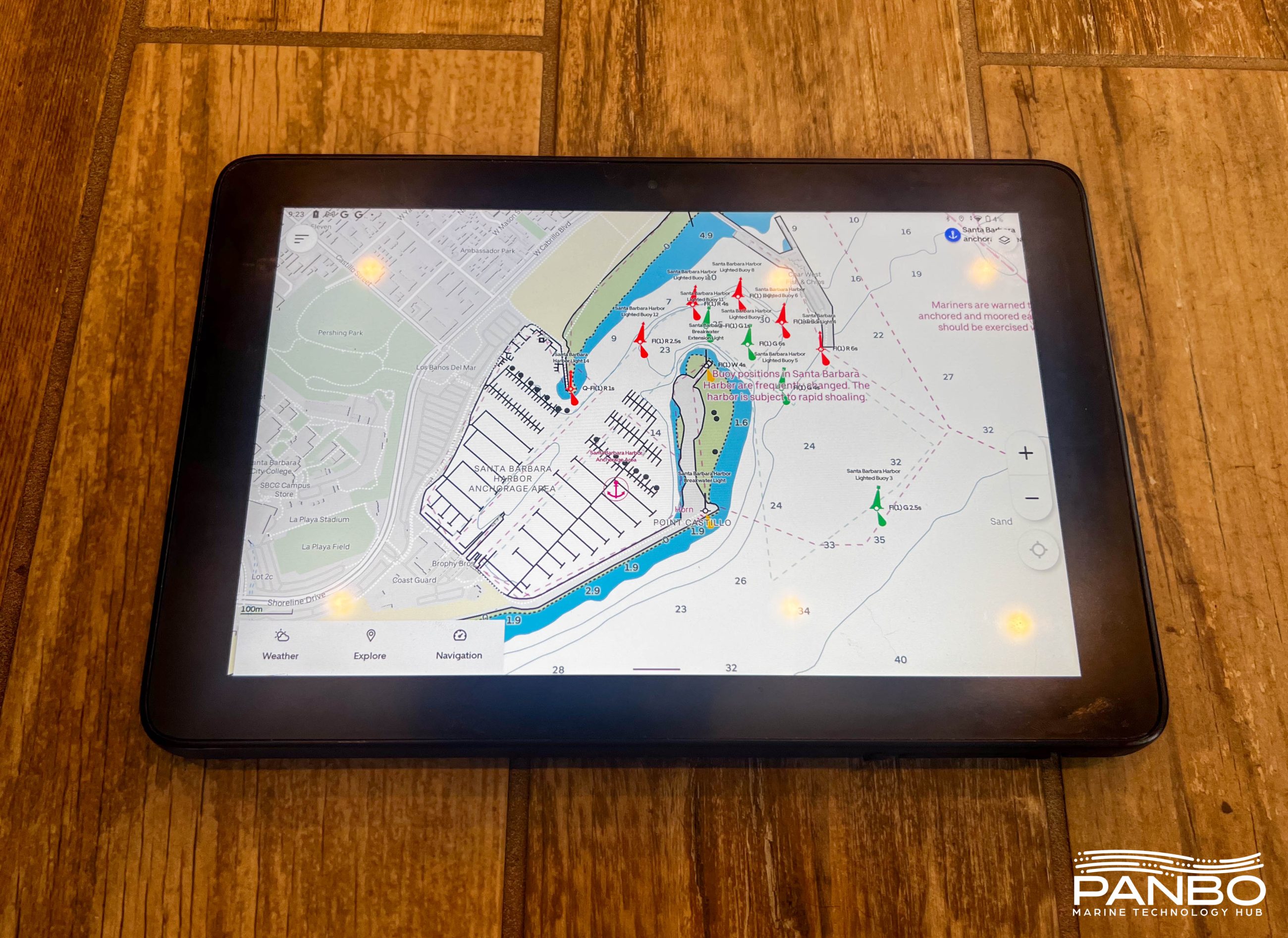
I’ve recently taken a look at the challenges of using a tablet as a primary navigation system. Orca has set an ambitious goal of addressing many of the challenges associated with using a tablet as your primary navigation system. With their hardware options and software subscription, Orca has options to fit many types of boats and boaters.
The system
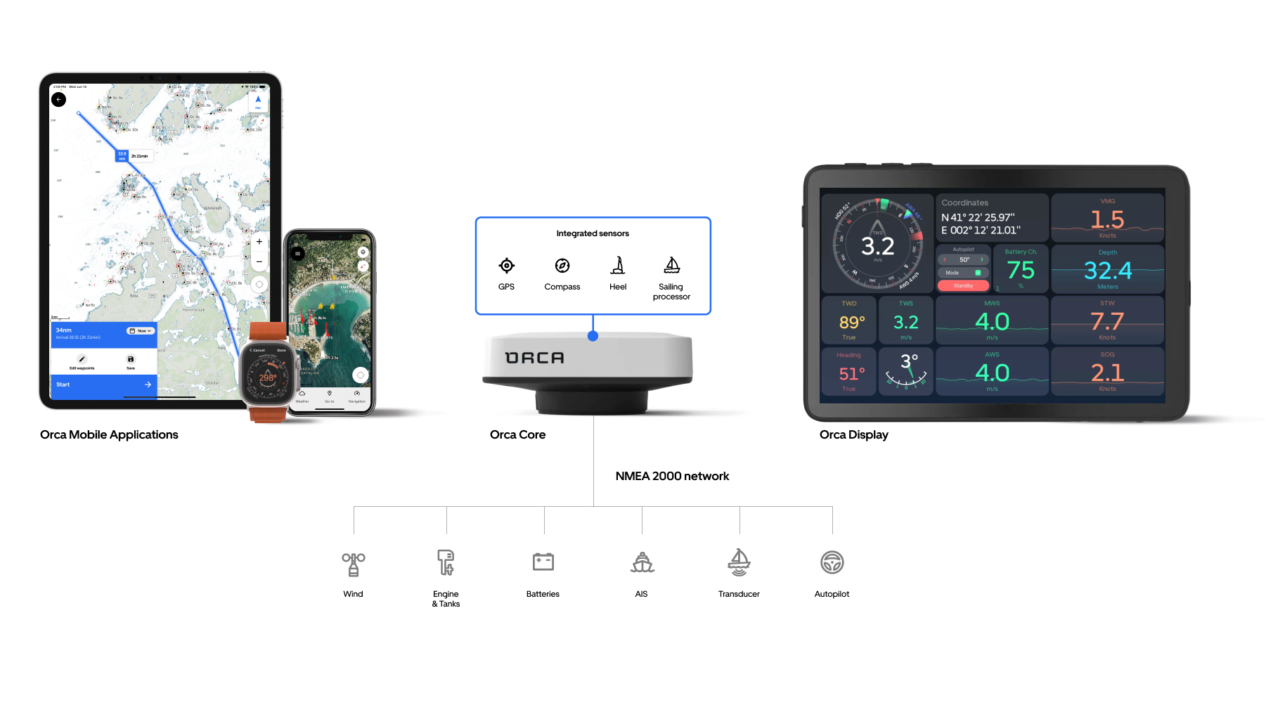
Orca’s system is comprised of their app, Orca CoPilot, running on your tablet or theirs, and the Orca Core, an NMEA 2000 connected GNSS receiver with a 9-axis IMU and WiFi and Bluetooth radios. Orca’s modular approach captured my attention. I like the idea of adding the core to your NMEA 2000 network and then being able to use my tablet, phone, or a dedicated, marinized tablet.
Orca CoPilot app

Let’s first take a look at Orca’s app. You can run the app on your own iPad or Android tablet, you can use the Core or not, but if you’re going to use any part of Orca’s system, you will use their app, CoPilot. Ultimately, I think it’s the software that will determine Orca’s success. There are quite a few navigation apps out there. In fact, one of my summer projects is to produce an updated comparison matrix of all of them, so first, let’s see how CoPilot compares.
| Aqua Map | Navionics Boating | Orca CoPilot | |
| Auto Routing | X | X – including sail routing | |
| Supports external GNSS/Depth | X | X | X |
| AIS via WiFi | X | X | X – also supports internet AIS aggregator |
| Wind via WiFi | X | X | |
| Engine info via WiFi | X | ||
| Autopilot controls | X | ||
| Real Time Tracking | X | X | |
| Crowd Sourced Data | ACC and Waterway Guide | ACC only | |
| ACOE Survey Data | X | ||
| Location Sharing | X | X | X |
| Anchor Alarm | X – with remote monitoring via Internet connection | X | X |
Orca has hit the ground running with some pretty significant features and deep integration with their Core hardware. As you can see from the list above, they have a strong feature set, including some features not found in either Aqua Map or Navionics, the two leading apps in my opinion.
Auto routing
For a long time, if you wanted an app with auto-routing, your only choice was the Navionics Boating app. But a recent crop of apps, including Argo, Savvy Navvy, and Orca, have launched with auto routing as one of the core features. I don’t know if it makes me a curmudgeon, but I remain very suspicious of automatically built routes. Over time, I’ve seen the routes get better and more logical, but regardless of the auto-routing engine, I also continue to see potentially dangerous detours automatically plotted. The Orca Facebook Owners’ Group has several examples of routing anomalies, but in my waters, I can report the routes have been generally accurate and safe.
Sailing routes
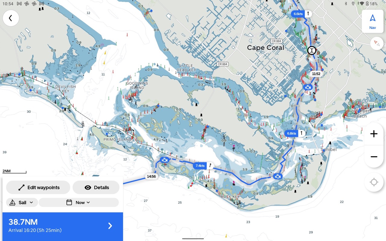
I believe Orca’s stand-alone sail routing capabilities are uniquely capable and easy to use. The only other similar automatic sail routing I know of comes from Predict Wind. When selecting a route type, you have a choice between manual, engine, and sail. Manual routing leaves all the decisions up to the operator. Engine routing will build a route planned around using the engine for your entire trip. Sail routing will sail when appropriate and call for engine use when that’s appropriate. If you look at the screenshot above, you will see engine icons in numerous spots while in others you will see a wind speed indicator and an arrow indicating a sailing leg. Additionally, engine-powered sections of the route are hashed while sailed portions use a solid line.
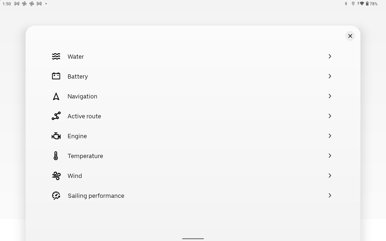
Instrument display
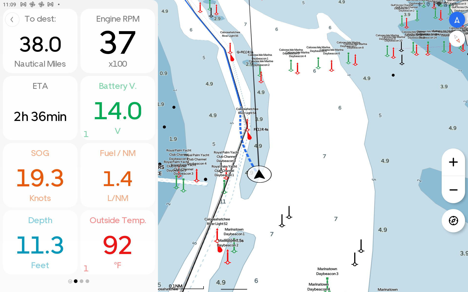
Compared to the vast majority of navigational apps, CoPilot offers a great deal more options for displaying data and can display more data than any other app I’ve seen. I’ve long wondered why other apps don’t allow the relatively straightforward option of displaying data received from the NMEA 2000 network. I’m really pleased to see Orca take advantage of this data and allow clear and easy display of the data.
Weather
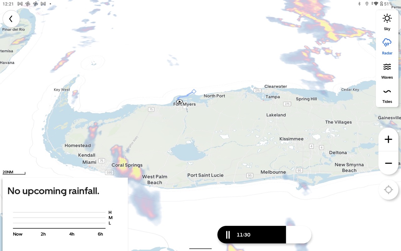
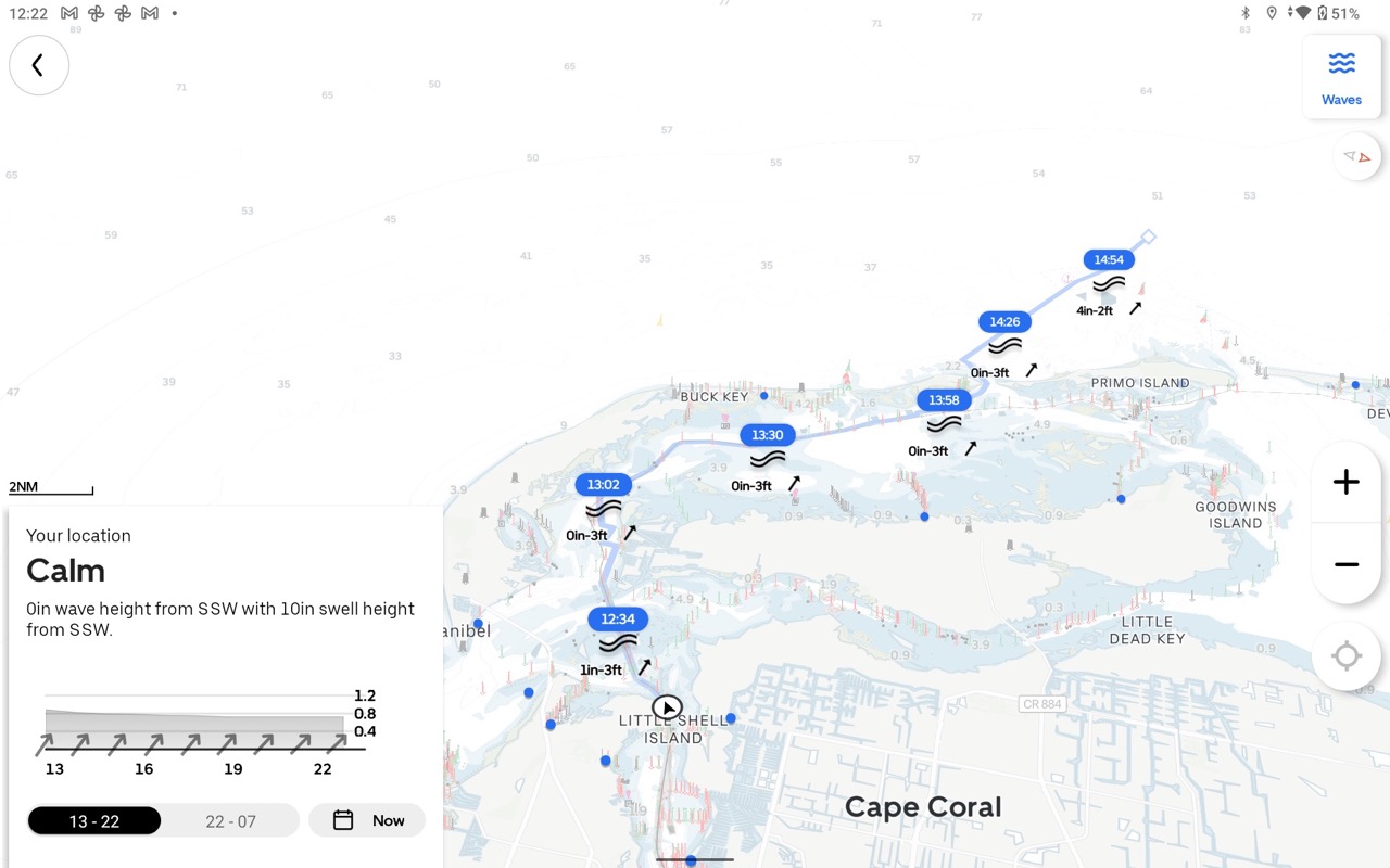
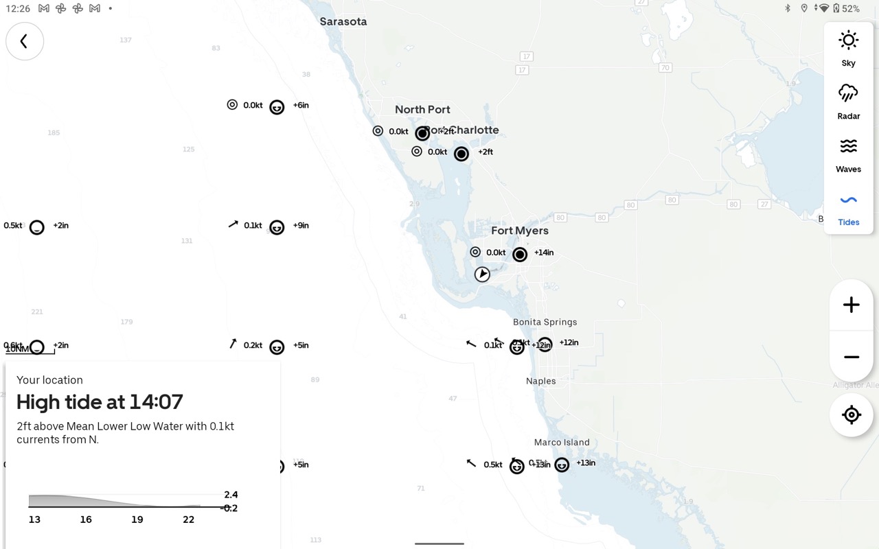
Orca offers general conditions (they call it air), radar, wave, and tide weather information. Most of the weather can be displayed for current or upcoming conditions. If you have an active route, the weather will be displayed along your route.
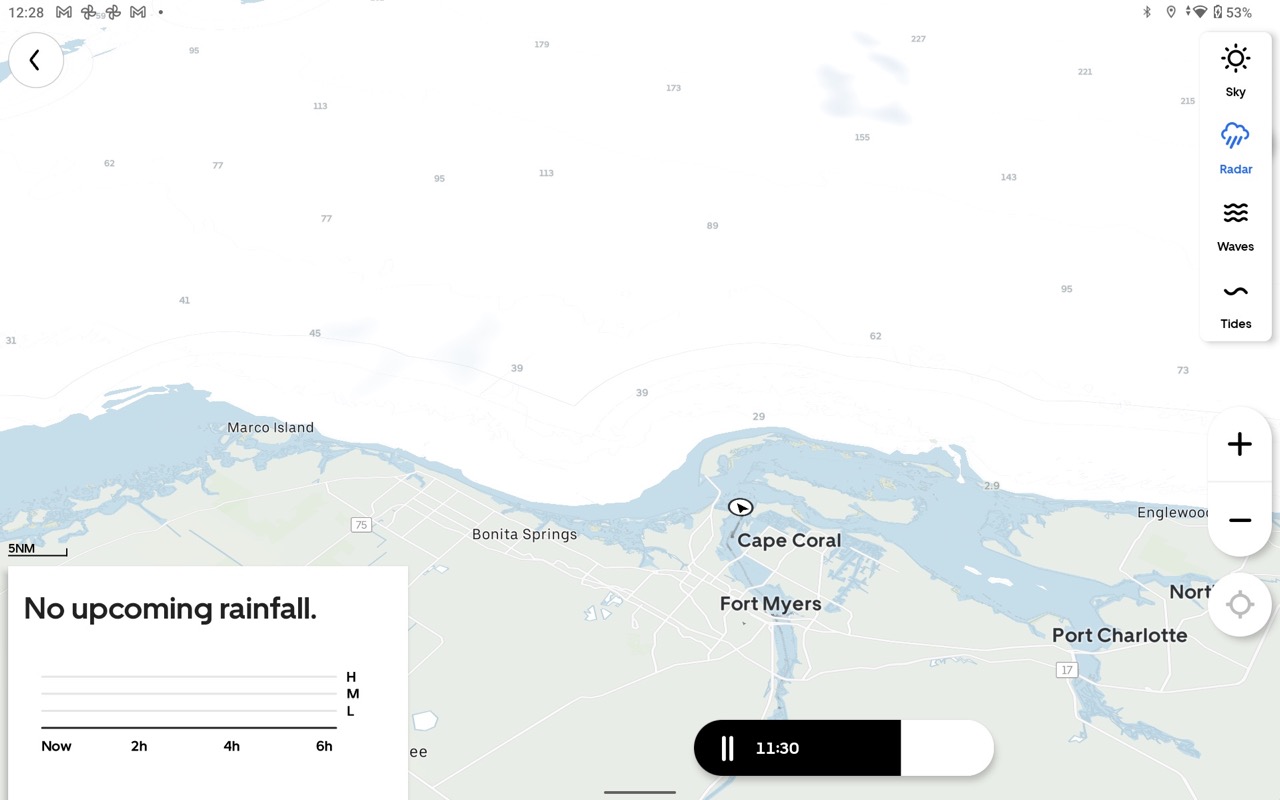
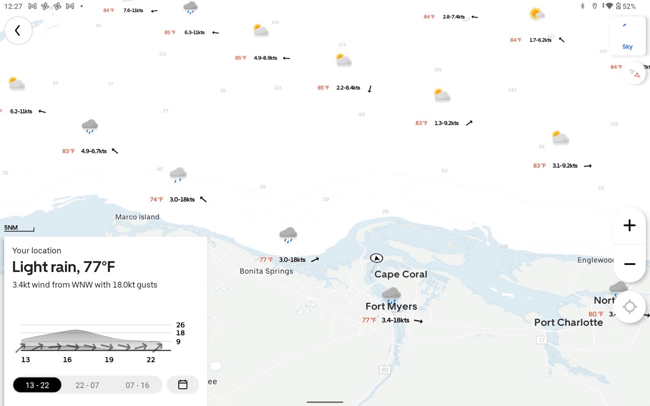
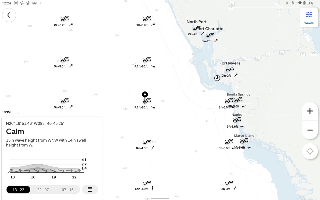
I did come across a few anomalies with the weather forecasts. In the examples above you can see the current sky conditions show light rain while the radar is showing no upcoming rainfall. Perhaps, the light rain is about to end and there’s no more rain in the forecast? But, I think the next one is a little tougher to explain. The graphical wave forecast shows 4-8 foot seas in the area of my pin, but the detail on my pin is showing 14-15 inch waves.
AIS
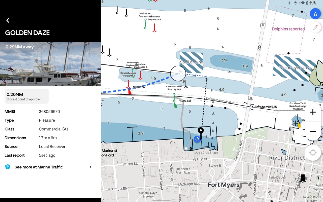
CoPilot receives AIS data via NMEA 2000 and augments that data with information from Marine Traffic. Or if your boat isn’t equipped with an AIS receiver or transceiver, the app can display AIS info from an internet aggregator of AIS information.
Sailing features

I already touched on Orca’s sail routing capabilities in the auto-routing section, but there’s quite a bit more to Orca’s sailing features. Orca touts their sailing processor in a recent blog entry. The sailing processor, a feature of the Core, is capable of calculating apparent and true wind as well as compensating for potentially inaccurate sensors on the boat. I’m the wrong person to take a deep dive into the full realm of sailing features, but my reading of the Orca Owner’s Group suggests people are mostly happy with the functions while also seeing some opportunities to further refine the calculations.
Premium subscription
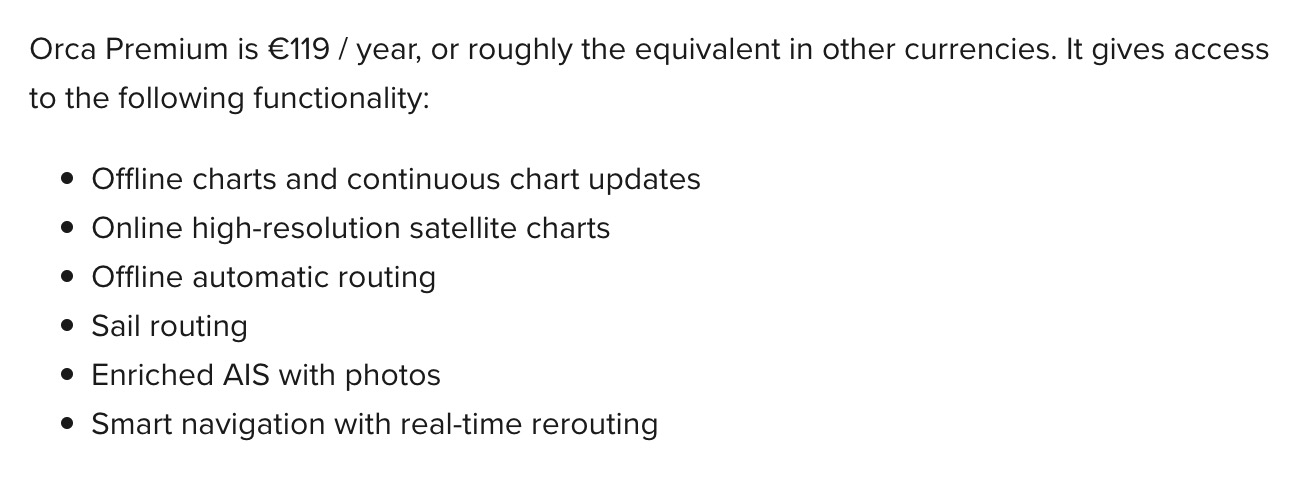
Purchasing a Core or Display 2 gives a year subscription to Orca Premium. Otherwise the subscription costs €119. The premium subscription includes offline charts, auto-routing, and more. But, the app can be used for free on your tablet with somewhat reduced functionality. As long as your device remains online, you can get a good feel for the app.
Rapid updates
Orca follows a weekly release cycle for the CoPilot app. Their release notes show that some of those updates are small while others include pretty major changes. In the time I’ve been using the app, I’ve seen quite a few changes and improvements. I’ve also seen Orca be quite responsive to my suggestions as well as those made by members of the Facebook Owner’s group. It has been gratifying to see rapid response to bugs and opportunities to improve.
Orca Core

The Core is a $500 (U.S.) NMEA 2000 component that provides location information, heading data, and acts as an NMEA 2000 to WiFi and Bluetooth gateway. Core also records your trips and stores data about them for later uploading. Orca uses Core to seamlessly allow connectivity between the tablet, an Android or iOS you provide, or their Display 2, and the boat’s NMEA 2000 network. That connectivity allows the app to receive GNSS information (from the core or from a GNSS receiver on the NMEA 2000 network), display gauge information, and control of Garmin, Raymarine, and Simrad autopilots.
Core includes an 800 megahertz ARM processor and does extensive processing on the device, including the sail processor functionality I mentioned earlier. Plus, Orca has been able to work around the typical data limitation most nav apps experience. Typical NMEA 2000 to WiFi to nav integrations actually use NMEA 0183 formatted data for the information exchange. As a result, information types that don’t have NMEA 0183 sentences, like battery information, digital switching, and engine information are either limited or not available. It appears Orca is using a direct NMEA 2000 data stream since they’re able to display a much fuller dataset.
If my speculation is correct, that should also mean that Orca could support NMEA 2000 alerts and easily display those alerts. Thus, helping to address the dearth of NMEA 2000 displays that support alert PGNS.
Currently, Core only works with the Orca app. So, it can’t be used as a NMEA 2000 to WiFi gateway with other navigation apps. But, Orca says that feature is on their roadmap and should be enabled later this year.
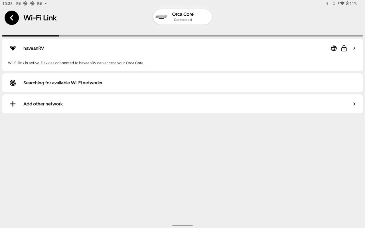
Mobile devices connect to the Core either via Bluetooth or WiFi. In my testing, I found the Bluetooth connection simple and reliable, but some functions require a WiFi connection. Many mobile devices, especially those running iOS, frequently disconnect from a WiFi network that doesn’t have an internet connection available. If there is an existing, especially internet-connected, WiFi network on the boat, Core can connect to that network. Thus, all devices connected to the boat’s network, have access to the Core.
Physical installation
Core offers several mounting options. It can be mounted by drilling a hole in a horizontal surface, inserting the threaded shaft through the hole, and tightening a collar. Alternatively, Orca includes an adhesive disc to allow surface mounting, in which case the threaded piece can be removed. The Core can be mounted in nearly any orientation. On their site, Orca shows the Core mounted on its side in a cabinet near a nav station. Core needs good visibility of GNSS satellites and separation of more than 1 meter from sources of magnetic interference.
On Panbo(at) I mounted the core on top of the center console and definitely less than 1 meter from potential sources of magnetic interference. Thus far, I haven’t noticed any troubles with heading information. The Core is water-resistant and suitable for mounting in an exposed location. I mounted the core upside down using the 3M hook and look fasteners you can see stuck to the top.
Orca Display 2
The Display 2 is a $1,000 ruggedized Android tablet perfectly suited for use on a boat. Tablets aimed at general-purpose applications focus their design on being thin and light. It turns out that thin and light aren’t the primary attributes most boaters care about. I’ve previously written about using tablets for navigation and the potential advantages and disadvantages. I’d say Display 2 does a nice job addressing the majority of the disadvantages while retaining nearly all the advantages.
Display
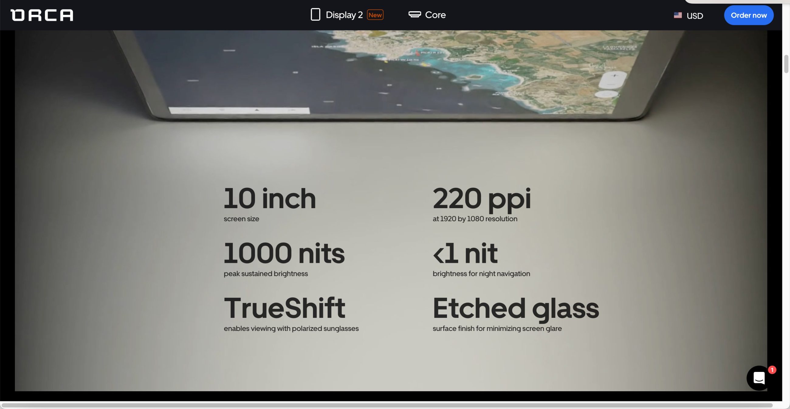
When I first unboxed and powered on the Display 2, the first thing I noticed was the brightness of the crisp display. I don’t wear polarized sunglasses, but I did grab a pair of my wife’s and could quickly see the Display 2’s advantage compared to an iPad Pro 10.5 and a Samsung Galaxy S5e.
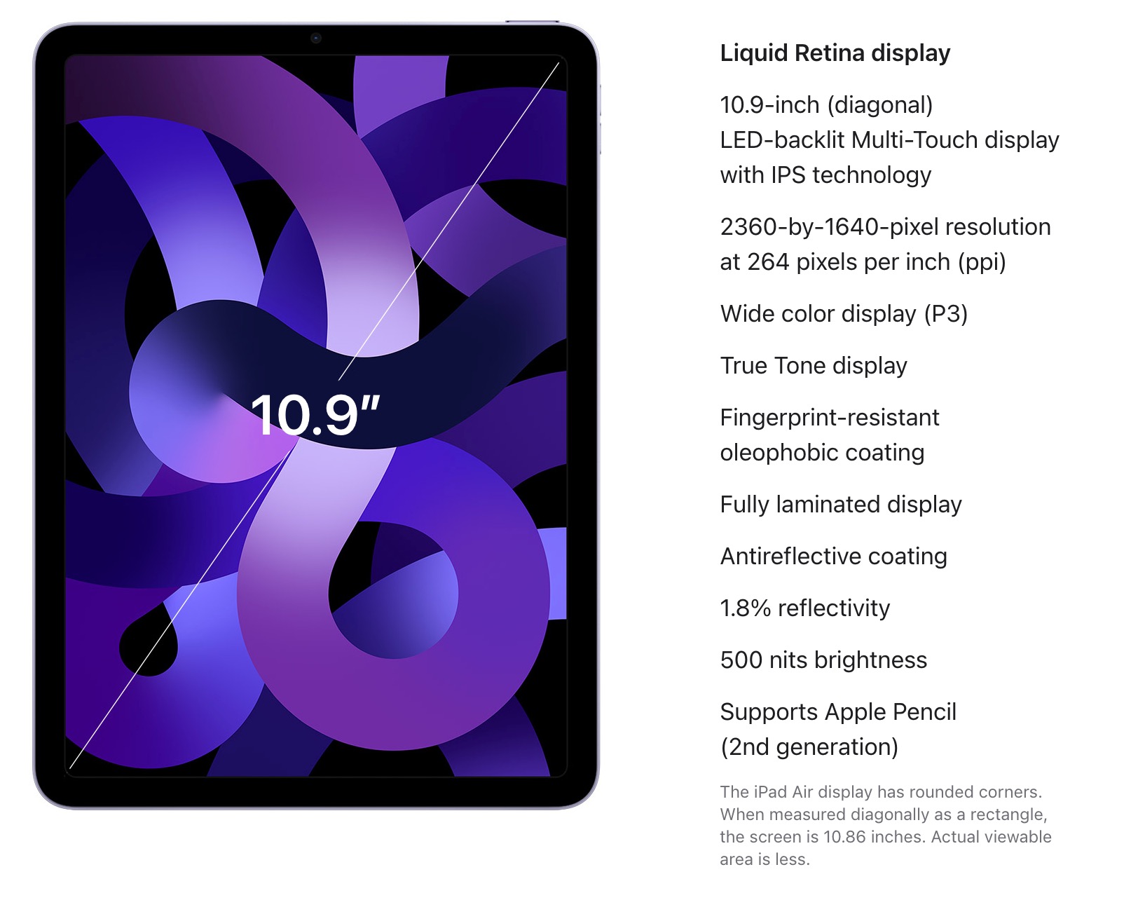
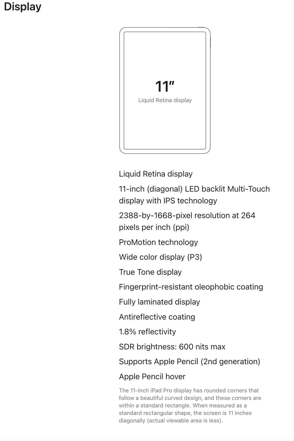
The press release for the Orca Display 2 generated a lot of discussion about the display, comparable brightnesses, and possible resolution shortcomings. First, let’s talk about brightness. Display brightness isn’t reported in a manner that makes comparison easy. For example, Orca lists the brightness of the display as 1,000 nits peak sustained brightness. Apple says the 11-inch iPad Pro can achieve 600 nits max brightness and the 10.9-inch iPad Air is rated at 500 nits. Samsung doesn’t publish any brightness specs, but Tom’s Hardware measured the current flagship Galaxy Tab S8 11-inch at 480 nits maximum in the center of the display. But no matter what ratings are used, to my eye, the Display 2 is brighter than either my Galaxy S5e or iPad Pro 10.5.
The Display 2 is also lower resolution than either of the other tablets. At 220 pixels per inch (PPI), its specs lag behind both the iPad’s 264 and the Galaxy Tab’s 290. However, without looking up the specs, at my helm, there’s no way I could pick out higher and lower resolution. In fact, the Display 2’s 1920×1080 resolution is in line with what nearly every MFD uses, including monster displays like Garmin’s 8624. The 8624 is actually 1920×1200 due to the screen ratio, but that calculates to under 95 PPI!
Performance
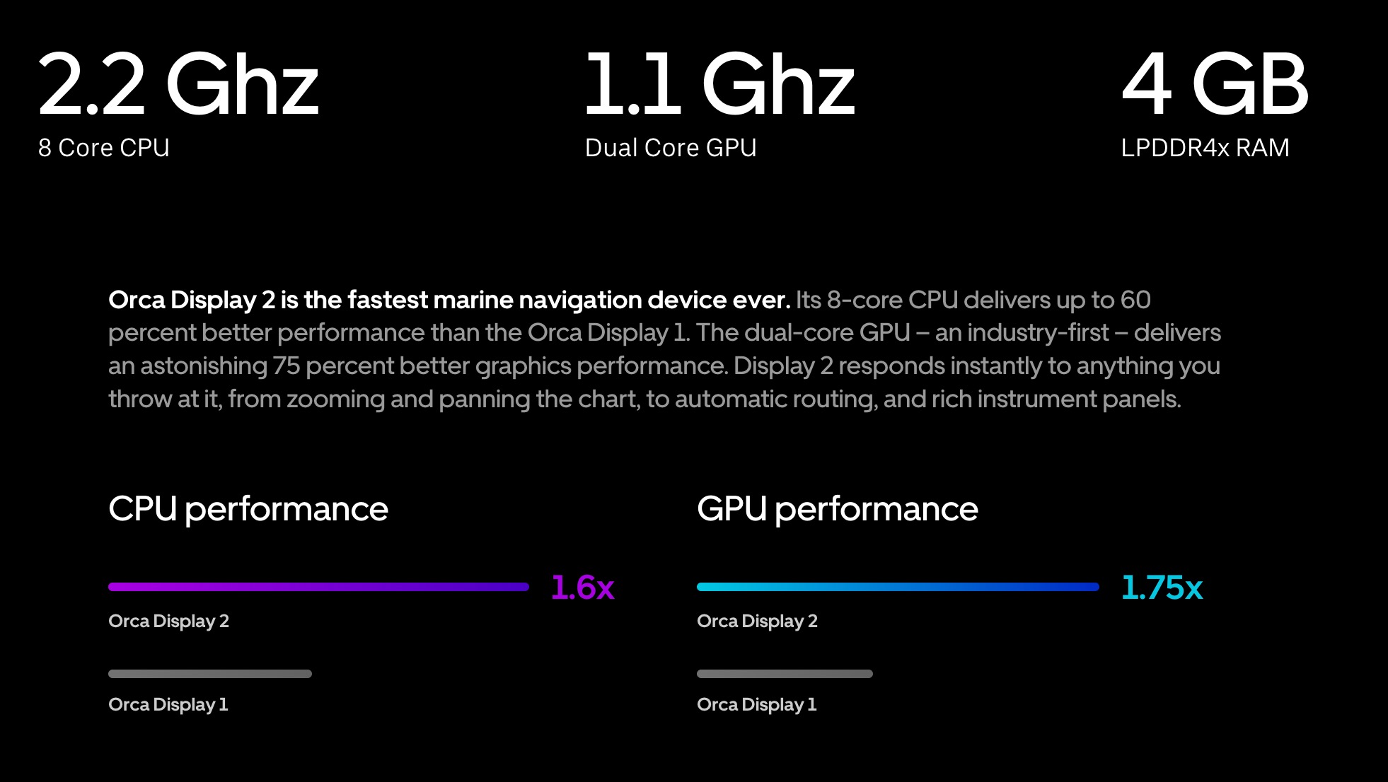
The display 2 boasts an 8-core, 2.2ghz processor, dual-core GPU, and 4 GB of RAM. These specs are all comparable to current tablets. iPad Airs and Pros with Apple’s M1 or M2 processors have more raw horsepower, but in using the Display 2 I haven’t seen any performance issues.
Battery life / Charging
Battery life and adequate charging is one of the biggest challenges of using a tablet. First, as tablets get hotter and run their displays at higher brightness, they use more battery power. Second, as batteries get hotter, the internal power and thermal management systems on the tablet may dial back charging to help shed heat.
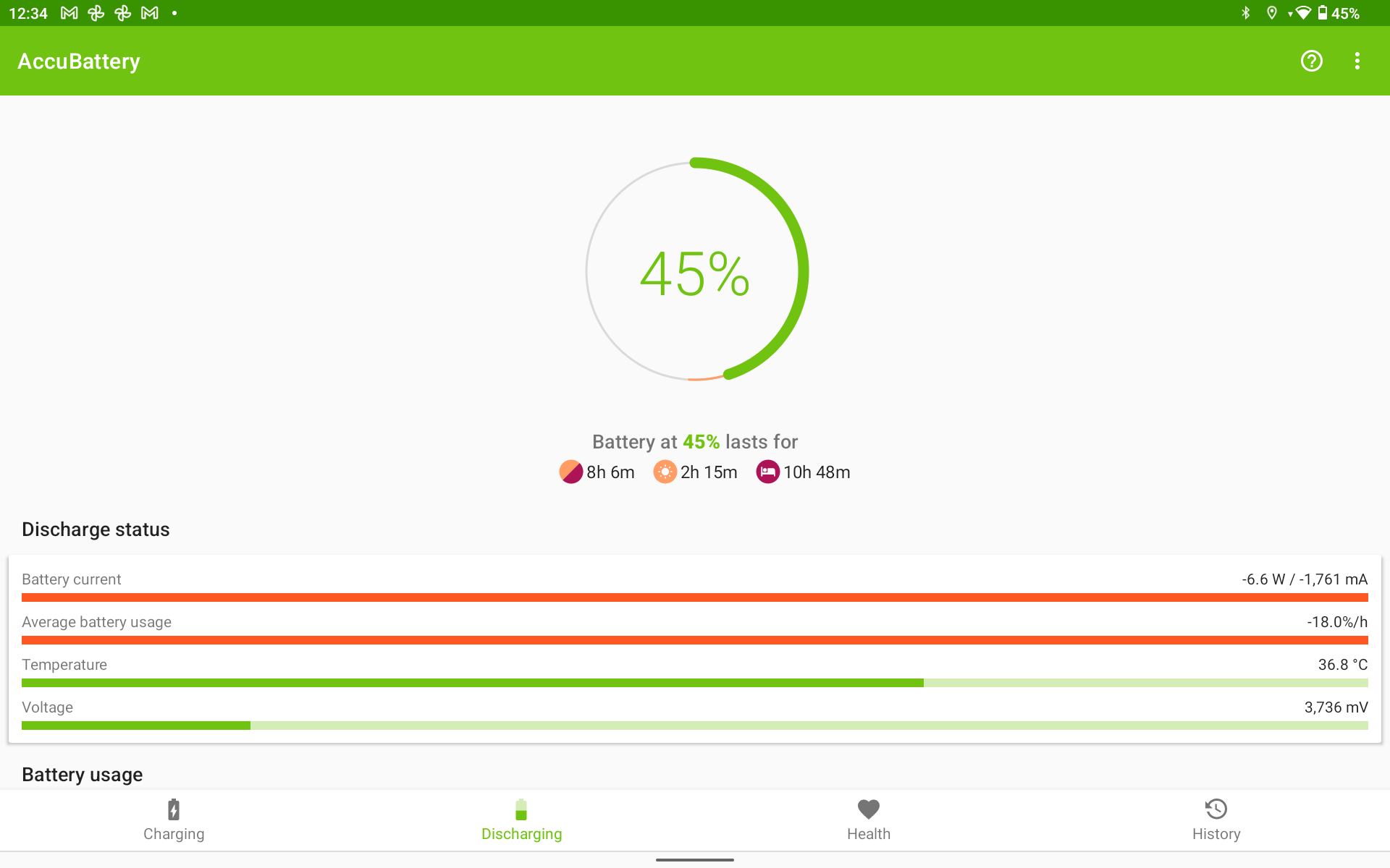
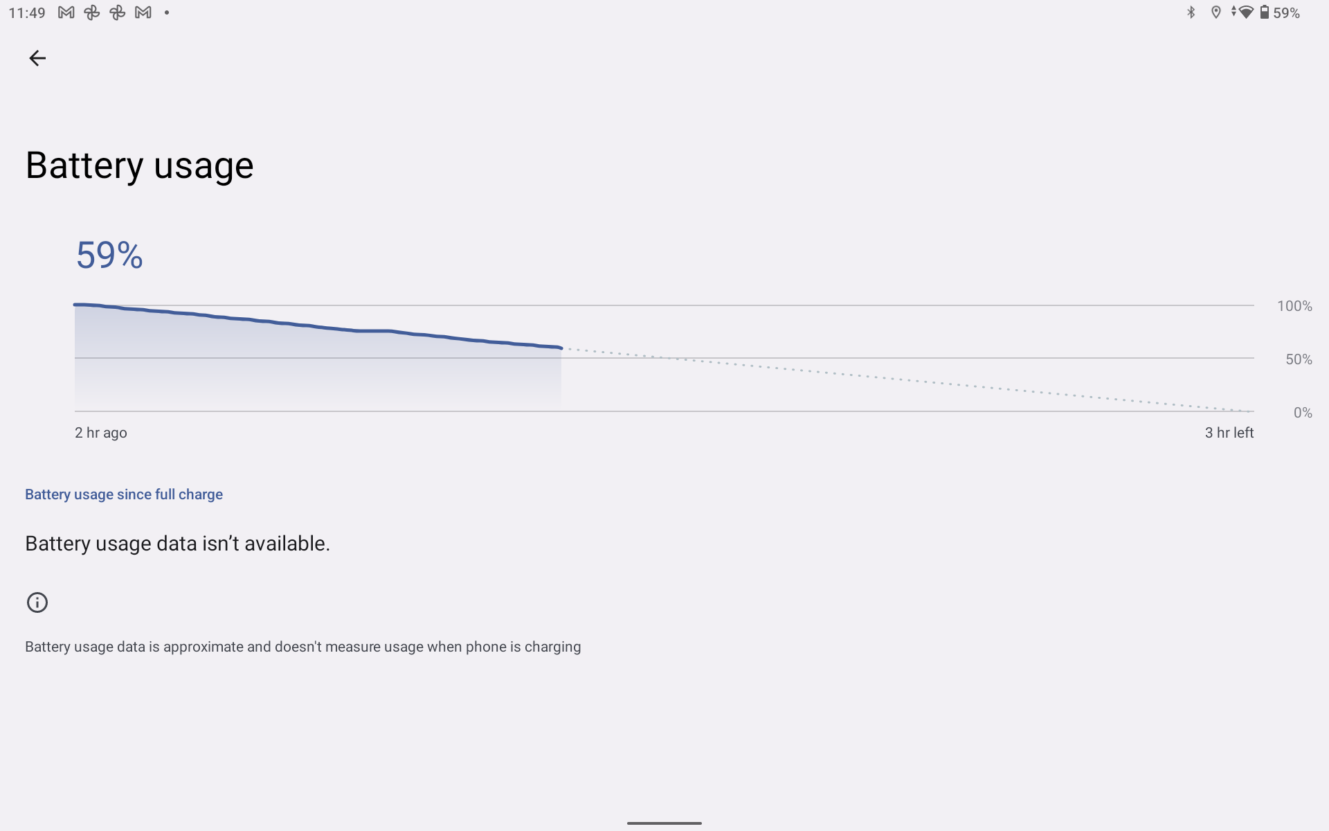
The Display 2 has a 9,500 milli-amp-hour battery. Orca says the battery will run the display for 8 hours of navigation. I’ve set the display not to turn off and turned the brightness up all the way. With those settings, I’m seeing it use 18-19 percent per hour or just over 5 hours of worst-case use.
Possibly more important than the battery’s ability to deliver power is the tablet’s ability to receive power from charge sources. I’ve had some struggles finding high-output 12-volt USB chargers that an iPad likes. Often, despite higher ratings, the iPad doesn’t seem to be charging as fast as the usage is discharging.
Orca charging mount

Orca’s Display 2 has three options for charging, all of which seem to allow faster charging than discharging. Those options are: 25-watt charging via the Charging Mount shown above, 15 watts via a Qi wireless charger, or up to 25-watt charging via USB-C. The $300 charging mount can be ordered either for flat mounting to a console or for the upright mounting pictured. The upright mount uses a Ram mount, so you will have access to the full suite of Ram mounting options if the included one doesn’t work for your circumstances.
The charging mounts have just begun shipping and I haven’t received one yet. So, I haven’t had the opportunity to gain firsthand impressions. But, I like what I’ve seen so far and also really like the positive mounting it offers to reduce the risk of damage to the tablet from being tossed around on the boat.
Real-world results
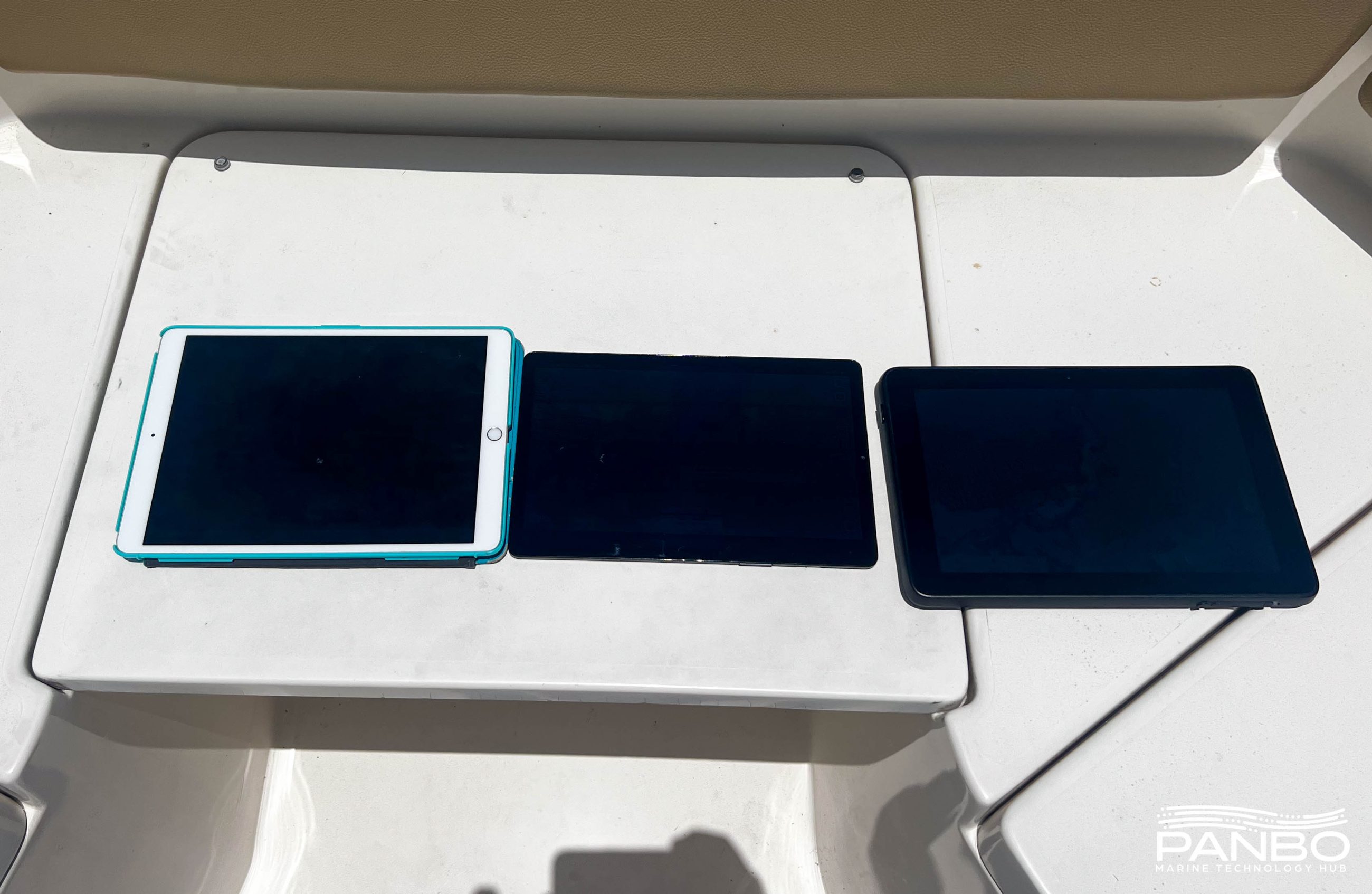
I spent some time on a ninety-plus-degree, sunny day with three test tablets out in the sun. I used an iPad Pro 10.5, a Samsung Galaxy Tab S5e, and the Orca Display 2. Despite what the appearances in the image above, all three tablets were on for the duration of the test.

With all three tablets in direct sunlight, I quickly noticed that the Orca Display 2 was definitely the most easily visible. It’s hard to capture that in photographs with the camera automatically adjusting for the extreme brightness of the day. Initially, the iPad and Samsung tablets had similar brightness, but the iPad’s thermal protection quickly kicked in and dimmed the display. The Galaxy Tab was slower to dim, but when I picked it up, the back was scorching hot. To a degree that I would worry about internal damage.
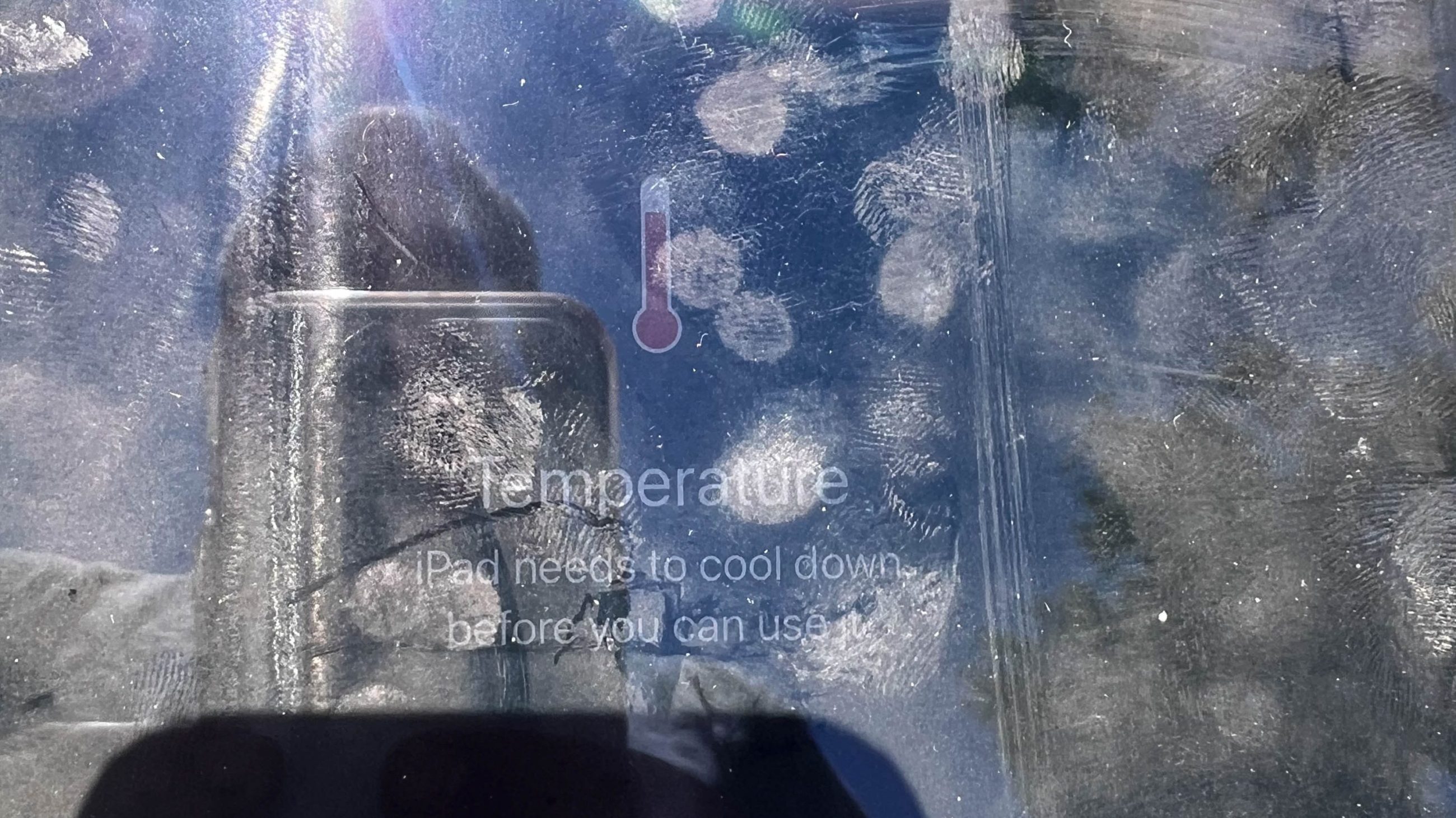
The Galaxy Tab did eventually dim its display but not as much as the iPad. Within about five minutes of being exposed to the sun, the iPad began displaying the temperature warning and stopped functioning. The Orca Display 2 never dimmed or shut down. Additionally, the plastic case of the Display 2 wasn’t noticeably hot.
Third-party apps
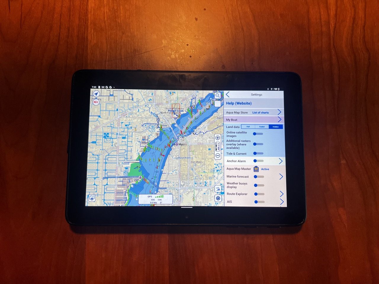
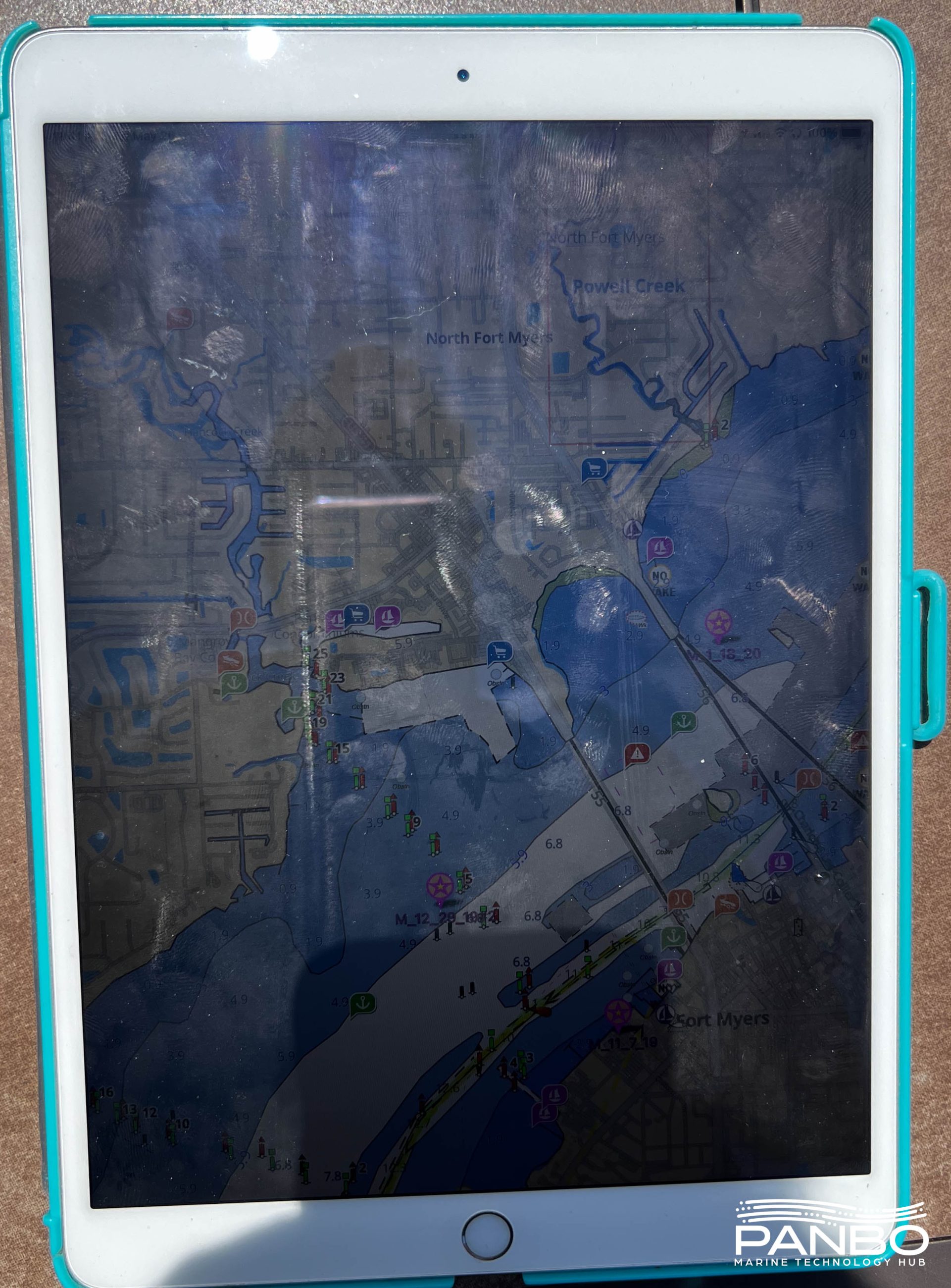
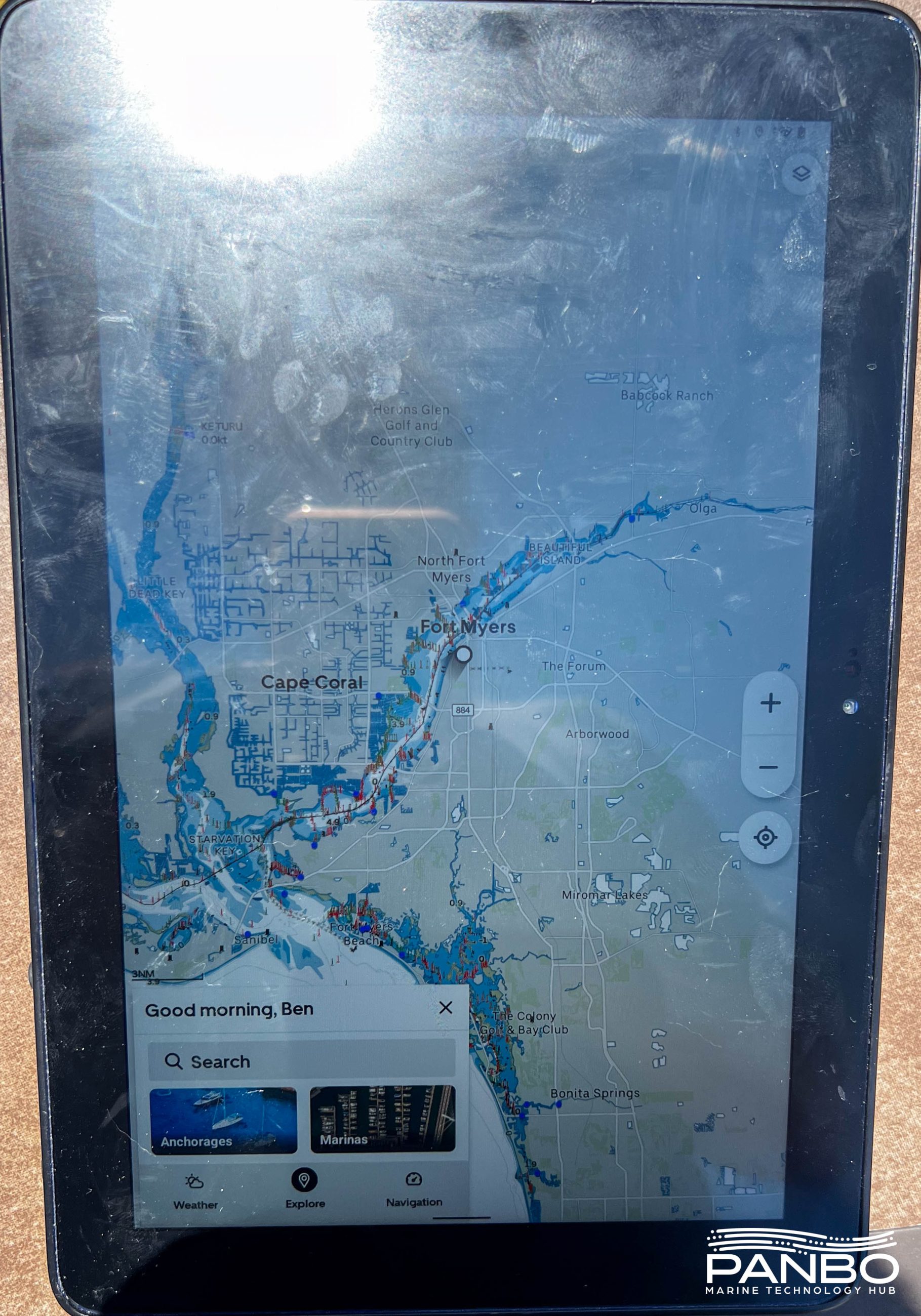
The Display 2 runs a version of Android. As a result, it can run Android apps, including other navigation apps. The picture above shows Aqua Map running on the Display.
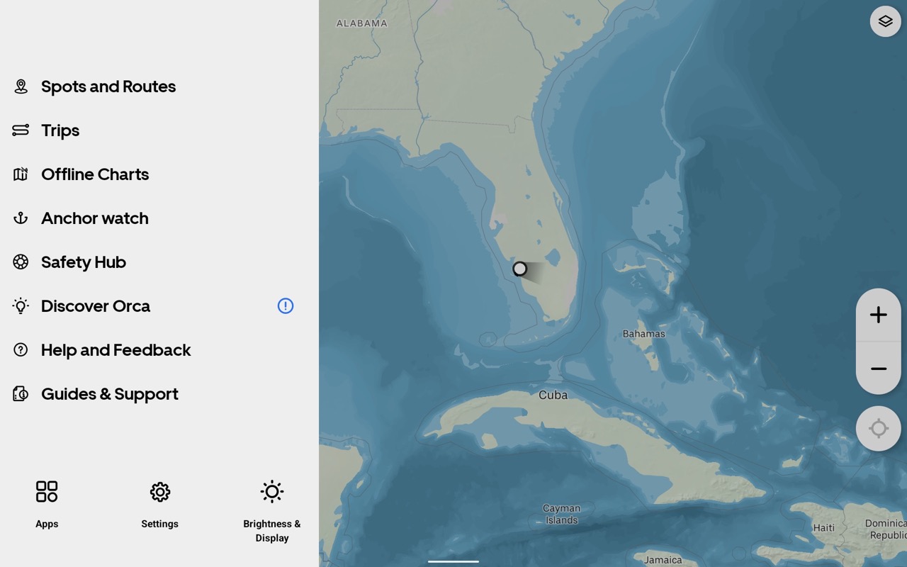
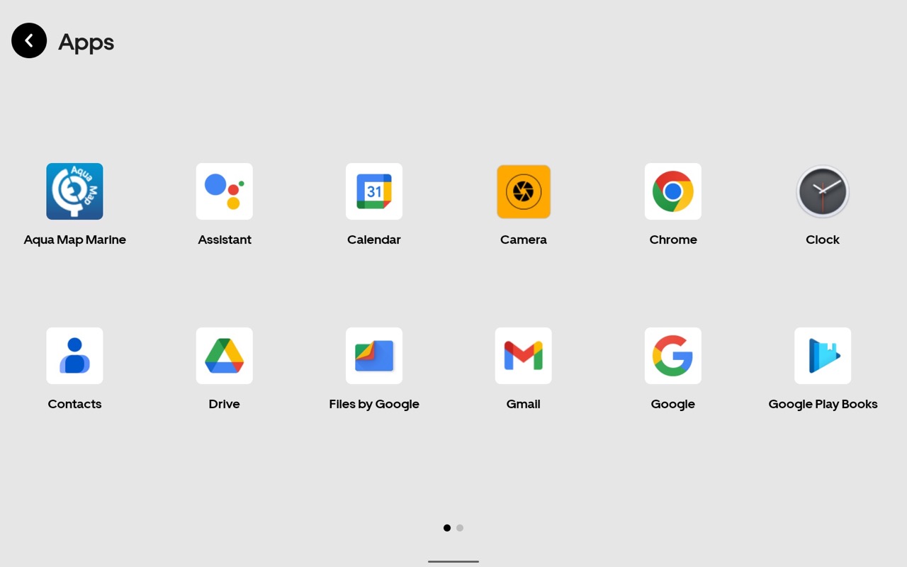
The Display automatically launches the Orca app as soon as it is turned on or unlocked. To access other applications, a press of the menu button in the app brings up the screen seen above left. Pressing the apps button in the lower left corner brings a full list of installed apps. The Display 2 is equipped with the Google Play Store, so apps are easily downloaded and installed.
Final thoughts
With claims of the ultimate navigation experience, Orca has set an ambitious goal for themselves. They’re delivering a lot to back up that claim already. Plus, with strong responses to user suggestions and weekly releases, they are able to respond to suggestions and improve the system quickly. I’m excited to continue to watch what they can accomplish.


Thank you for the great review! I’ve been watching the announcements for the Orca products and wondered if the hardware and software were going live up to the hype and be good enough to compete. Sounds like they are heading in the right direction. The only very minor suggestion I’d make is that I was able to get wind speed/direction on Aqua Map via wifi.
You’re correct, that was an oversight on my part and has been updated.
-Ben S.
Ben, will the Orca app incorporate the Bob423 tracks eventually? They are extremely helpful for AICW navigation. Also, will they incorporate the Explorer Chartbook recommended tracks for the Bahamas?
Most people do not know what goes into the forming of the Bob423 tracks, believing them to only be the tracks of one individual going along the ICW twice a year. Such is not the case. If an individual wanted to make his own tracks with the same degree of accuracy, he would have to follow these steps:
– travel the ICW twice a year recording tracks with depths
– pour over USACE surveys weekly for updates to depths and forming shoals
– have contacts in USACE send you dredging contracts so you know where the dredging channels will be in newly dredged areas. In saving money, some of the channels are only 75 ft wide and can easily be missed – some are not in the visual center. The contracts detail exactly (for environmental reasons) the path, width, snd depth of cut. I convert the centerline of the path to a Bob423 track through the dredged area.
– collect tracks with embedded depths from other boaters for analysis and updates. For me, that’s the Bob423 surveyors who travel the ICW throughout the year with the sane setup I have, embedding depth reading into the track data using Aqua Map.. Other boaters would have to develop their own network.
– collect verified depth data on new shoals from my 19,000 member ICW Cruising Guide Facebook page
All of the above data is then incorporated into revised tracks as required, sometimes with weekly updates, but usually every few months throughout the year.
Thanks for jumping in on this discussion, Bob. Is my understanding correct that your Tracks are only currently running on AquaMap? Would it require a licensing agreement for other Apps to be able to integrate them?
They are free to be used on any navigation device that accepts GPX files.
Aqua Map does not own the tracks, I do, and they are free to use anywhere.
Hey, Kristian from Orca here.
Fantastic work you are doing. We’d be super happy to incorporate these GPX tracks as part of our chart processing pipeline. We’re constantly adding new data sources, and while our current focus has been in Europe, we’re shifting focus westwards very soon.
Do you have any “master GPX” file that contains all of your latest tracks, or would you advise us to download section by section?
Robert Sherer (aka Bob423) today shares his GPX tracks freely and they can be put on other Apps already.
This is from an early version of Orca, but may be in the current app, or could be:
“For import routes (from *.gpx, *.rtz and *.rt3 formats) tap Import button and select route from the iOS Files folder”
https://www.sevencs.com/data/uploads/pdf/opx_user_guide.pdf
Ben: Nice article on Orca. Competition improves the breed! I’m a volunteer beta tester for Aqua Map. I’d point out that it does indeed show WIND data. Also Aqua Map users can contribute their recorded track data (encoded with depths) to NOAA and the International Hydrographic Organization’s Crowd Sourced Bathymetry project.
Ben: Nice article on Orca. Competition improves the breed! I’m a volunteer beta tester for Aqua Map. I’d point out that it does indeed show WIND data. Also Aqua Map users can contribute their recorded track data (encoded with depths) to NOAA and the International Hydrographic Organization’s Crowd Sourced Bathymetry project. And one can “publish” one’s user data (tracks, routes, waypoints) for other Aqua Map users to download or automatically keep in sync.
You’re right on both points. As I mentioned, I’m planning on doing a roundup of all the tablet nav apps out there. The reality is even that will struggle to capture all the features and differences of the apps. That’s especially true of Aqua Map and some of the advanced implementations they’ve done. For example, while many apps have anchor alarms, I think Aqua Maps’ is differentiated for its advanced features and remote sharing.
-Ben S>
In the table there is also a wrong information regarding the Crowd Sourced Data. Only Aqua Map has both ACC and Waterway Guide data.
You’re right Giorgio, my apologies. I had Aqua Map and Navionics’ crowd-sourced information swapped. I’ve fixed that and updated to indicate Aqua Map supports wind data via WiFi.
-Ben S>
It looks to me like Orca has unlocked tremendous potential — much of it already realized — by combining their WiFi app and optional tablet with a certified NMEA 2000 sensor that also obviously contains a lot of processing power. An especially impressive example, I think, is their multi major brand autopilot control:
“Once connected, Orca’s Autopilot Control is seamlessly integrated into the autopilot network – and it will mirror the controls and status of your standalone autopilot display. Any interaction you make in Orca will be shown on your standalone display and vice versa.”
https://getorca.com/features-and-functionality/autopilot-control/
https://getorca.com/blog/orca_autopilot_control/
Does anyone know how to speak to a person in this company please?
Reach out via [email protected]
Hi Ben, thank you for this article on Orca. As for sailing routing did you have a look at Weather4D, https://www.weather4d.com/. This navigation app focuses at sailing routing and I have been using it in Europe, Brasil and the West Indies. They have a great support and Manual in English.
-Jochen-
Hi Ben,
I don’t think you are a curmudgeon in the least… auto routing makes little sense. It’s just good seamanship to create your route and KNOW your route. There is simply no reason to entrust the safety of your crew and boat to an algorithm.
On another note, when you review nav apps, I hope you will include OpenCPN. It’s the best app out there because it is designed by people who actually are on boats rather than engineers sitting at a desk. It’s free and there are free charts for a huge area of the world… including MBTiles of satellite images. (see TheChartLocker.com for examples). No subscription needed and you can switch between multiple chart sources which is the safest way to navigate as all chart sources include errors somewhere. Install an inexpensive Pitufino nav gateway (https://www.pitufa.at/pitufino/) which DOES share all NMEA (0183 and N2K) to all devices and you have everything you need.
Cheers,
Bruce
Thanks, Bruce, for mentioning the Pitufino gateway. Indeed, this little box for 250 bucks gives you several Orca features like full Autopilot control, alarm integration, and it comes with sophisticated instrument/display apps for free…
Hi
Thanks for the review.
Does the Orca Display 2 work standalone without the Core unit?
Yes it does. It has built-in GPS and compass. Core is for those who wants sensor integration.
Thank you Kristian
Thank you for this great review. I’m seriously considering ordering one of these for use on charter boats and for work on comercial vessels.
I have two questions that I can’t find an answer to . Is there a suction cup mount on the market that is capable to support its weight and, as far as integration with boat sensors, will it read data sent from yacht devices YDWG-02?
It reads from YachtD. Those guys are fantastic at being 100% N2K compliant.
As for suction mount, yes, there is one that supports the Display 2’s weight.
https://rammount.com/collections/popular-components-c-size/products/rap-365-224-1u#
This one works well for non-planing. Wouldn’t use this in any fast or small vessels where vibration/shocks are present. In that case I’d go for a RAM clamp mount w quick release/clamp.
Actually, my bad. The Orca app itself will not read from YDWG-02. That said, you can run any app you’d like on the Display 2 in split screen with the Orca charts.
So Orca app will not read it but other apps like Aqua maps or Navionics, will. Is that correct?
Hi,
thank you for your great review.
I am about to order a “complete” Orca system.
But I can’t find the dimensions (lenght x width or diameter x thickness) of the core on getorca.com.
Can anyone of you post these please.
Tia Friedel
> 118 x 118 mm footprint. 35 mm height + 15 mm with mounting bracket
https://getorca.com/orca-core/
Thank you,
they just added the information.
Like the comparison chart showing differences between Aqua Map, Navionics and Orca.
An importgant point that is not covered by your chart – how current (or not) are the charts and ATON data for each?
I asked Navionics about currency of the chart data, and update cycles and got mostly evasive answers until I insisted on an actual answer which turned out to be that charts are reall only updated about once a year. All that update stuf offerd daily – is likely sonar chart and active captain data. NOT new charts or new ATON data.
Aqua Map updates charts within a few weeks after NOAA releases new charts, Similar for updates for Army Corps of Engineers data. USCG ATON data is updated swiftly. This is why Aqua Map is the app I trust the most. Plus, with Aqua Map you long press on the screen and see the age of the underlying NOAA chart data, or Army Corps of Engineers data. I have never figured out a way to see that info in Navionics.
Orca – I asked months ago, and the answer I got was not encouraging. To be fair, I don’t remember the precise answer, but the gist was that they updated charts only infrequently and that USCG LNM or light list corrections were not part of any interime updates.
Marine charts are never as up to date as you would like, But, of the three – I think Aqua Map does the best in giving you the most current data.
Robert, I agree that Navionics is lax at providing source/date info about their chart data, whereas C-Map has historically been quite informative in this area, proving that it’s fairly easy to do. However, I think that someone misinformed you about how frequently Navionics processes HO chart updates. I believe it’s a high priority and is being done constantly. In fact, they claim 234,037 nautical chart updates in the last year, and those are differeniated from Sonar Chart and AC community edits:
https://www.navionics.com/usa/charts/features/daily-updates
Interesting. When I asked Navionics specifically, how long after NOAA publishes new data will it show up on Navionics, the answer I eventually got was that new NOAA chart data was incorporated on a rolling cycle, but about once a year.
Entirely possible that I got bad info. Since I had trouble getting Navionics to answer the question at all, and early responses suggested tech support didn’t actually understand the question.
Navionics updates their charts on different cycles depending on the feature. The ATONs are updated manually based on the LNMs and occasionally from mariner input. However, they occasionally miss an ATON, sometimes critical ones like they did at the confusing ICW area just north of Beaufort, NC. They did a manual update to the ATON locations there after reading my note. They also lag the LNMs data, it takes time to move the ATON icon on their charts (SonarChart and Nautical Charts). Aqua Map Master updates ATON locations using the weekly digital version of the LNMs issued by the Coast Guard, no manual intervention required, no delays.
SonarChart is the main driver of the data volume of updates with the vast majority of data devoted to redrawing depth contours based on boater uploads using their proprietary algorithms that they do not share. The user has no way of knowing the dates of the uploads that the contours are based upon. However, the contours always lag the actual depth in areas that change the most such as Lockwoods Folly, Browns Inlet, and many other such areas. However, SonarChart is quite good in stable areas like Jekyll Island where their contours overlay the USACE survey almost exactly.
Aqua Map updates their base NOAA charts four times a year. They update the USACE surveys as they are uploaded by each USACE district which depends on the frequency of the surveys. It can be as quick as a few weeks or less for a rapidly shoaling area like Lockwoods Folly to a year for long stretches of the ICW not near inlets. You always know the age of the USACE survey being displayed as you pointed out by using a long press on the survey.
Navionics seems to do a bottoms up update of the Nautical Chart about once a year from the NOAA charts for features such as contours. This can be seen in their Nautical Chart contours for Jupiter Inlet and other places.
My observations above are based on my experience in using Navionics charts on the ICW. Perhaps their updates are more frequent elsewhere.
I asked Aqua Map, and their update cycle is faster/more frequent than I remembered:
Hello Robert,
NOAA Charts > weekly update
A Co E Surveys > weekly update
USCG data > daily update
Pietro
Aqua Map Support
Robert, yes. I got the update from Aqua Map too. I don’t know of any other app with weekly NOAA ENC updates formatted for their chart offerings. OpenCPN and SEAiq will load NOAA ENC charts as is but without the readability of Aqua Map charts. I plan on investigating charts from Navionics and Garmin and comparing them to the current NOAA ENC charts to track when a change in the ENC chart shows up in their processed charts. The last time I looked, they were on a yearly cycle for their processed chart offerings except for manual updates of ATON locations which were more often.
The daily update of ATON locations is amazing. I had thought it was weekly.
Of course, the jewel in all of this is the USACE surveys which are only included with Aqua Map, updated weekly.
Rosepoint Coastal Explorer adds new NOAA chart data on a very quick cycle as well. When I asked them, I believe the answer was that new NOAA charts are made available in Coastal Explorer within a couple of business days after NOAA publishes them. Not sure that I asked RosePoint about how quickly ATON changes are reflected.
I think there is a LOT to like about Aqua Map – the presentation of the Corps of Engineers survey data is just brilliant. And, Aqua Map is very transparant about the age of the data – I prefer to know if I am looking at recent data or old data.
I cannot find the info anywhere, is the orca core nmea-2000 certified?
Previously, Orca premium could only be purchased if you owned a Core or Display. As of today, Orca has changed that policy so premium is available independently of their hardware. They’ve published a blog post about it at https://getorca.com/blog/orca_premium_general_availability/.
I don’t think I realized this restriction when I published this review, but regardless, it’s gone now!
-Ben S.
Orca has announced the Core 2. Their blog entry (https://getorca.com/blog/orca_core_2_radar_support/) says the revised Core features all new internals. But, the most noticeable difference is the inclusion of an Ethernet interface (using the NMEA OneNet specified X-coded M12 connector) which enables connectivity with radar scanners. Out of the gate, Orca supports Raymarine Quantum radars.
The blog shows radar overlay views and I’m not sure if there is a traditional radar scope interface as well. But, the interface to control the radar unit looks quite elegant.
-Ben S.
Since Aqua Map will run on their system, will Aqua Map have access to the radar overlay?
I don’t think so. Aqua Map will run on their tablet, but the tablet is basically a ruggedized Android tablet. Their app can leverage WiFi to connect to the Core and utilize additional sensor data. My understanding is the Core’s data stream isn’t like the NMEA 0183 streams used by most nav apps. Even if Orca were to implement an 0183 stream, it wouldn’t carry radar data. For Aqua Map to display radar they would need to be able to decode the data stream and display it.
On the other hand, an Orca Display 2, paired with a Core 2, running in split screen mode with the Orca app and Aqua Map puts a lot of navigation information on that screen.
-Ben S.
Sounds right. Aqua Map only communicates via NMEA0813 over WiFi, and 0813 can’t handle the data throughput required by the radar interface.
One very small nitpicking thing, Army Corps of Engineers use USACE on all their websites, not ACOE.
Orca just announced the Core 2, and I’m impressed with the detailed testing they conducted and published versus the highly capable and accurate Furuno SCX-20:
https://getorca.com/blog/new-orca-core-2
I know this conversation is old-ish, but Orca just sent out an email pointing at this discussion, so here I am.
Your comparison list doesn’t include OpenCPN, arguably one of the giants in this space. The new Orca appears to support the Raymarine Quantum radar, making them a bit unique, but still well behind OpenCPN.
For a true navigation system, solid integration with radar, ideally more than one brand, is more than “nice to have.” Without radar, a nav app is really just a planning tool and backup system. It’s nice, for sure, but when the fog rolls in your primary system has to have radar.
Hi Harry, It would be great if someone using OpenCPN, especially with radar, would submit a guest Panbo article about how it’s set up and works, because we have never covered that well. But I’m not sure it’s fair to criticize it’s absence from Ben Stein’s comparison table above because the Aqua Map and Navionics Boating apps are most commonly used on iPads running iOS, which seems to be about the only operating system NOT supported by OpenCPN if I correctly understand this download list?
https://opencpn.org/OpenCPN/info/downloadopencpn.html
I’ll agree a good article is needed. It’s not me — I’m the kind of person who needs to understand the entire road-map to success before I start, and it’s a real science experiment. But maybe some day. Understanding all the pieces, and all that needs to be bought, is challenging. But I’m learning, and trying hard. I have a Pi4 I just came in to, so I’m playing with that, and I have OpenCPN on my laptop. But it’s really just a toy, something to armchair nav or look at tomorrow’s trip with. Until it’s at my helm, with radar, it can’t be more than that. The big thing that makes me nervous is a suitable screen for the nav (sunlight readable, fully powered, robust, and workable when the screen is wet). The second big problem is dual-station compatible — OpenCPN (and most others) do not share chart licenses, routes, waypoints, etc in seamless fashion like my Furuno does.
Being value conscious, I’m also not an i-anything user. iPhones are popular in the US, but the price-for-value is questionable — which explains why iOS only has a 25% market share world wide. I built a DIY fog horn controller based on an ESP32 microcomputer, complete with an Android “switch” for it, and discovered that to make a program for your own iPhone, you have to pay $99/year to Apple to be a developer — and if you let it lapse, they take the program off your phone! I investigated it to try and make it universal — I’ve published it on GitHub here https://github.com/sailingharry/Fog-Horn-Control , but you have to be an Android user to use it.