
Are tablets ready to replace chart plotters?
Apple’s Steve Jobs introduced the iPad in April 2010. At the time, I was working in financial services technology. The day it was introduced, I ordered a half dozen of them so we could try them out and see what this new-fangled computer without a keyboard might do well. That original iPad, with 256 megabytes of RAM, 16 gigabytes of storage, and a tiny app store was pretty limited. But, we’ve come a long way in the last 13 years and tablets can do an awful lot. But, are they a replacement for dedicated navigation electronics? Let’s take a look at the capabilities they offer and some of the remaining limitations.
The allure of tablets
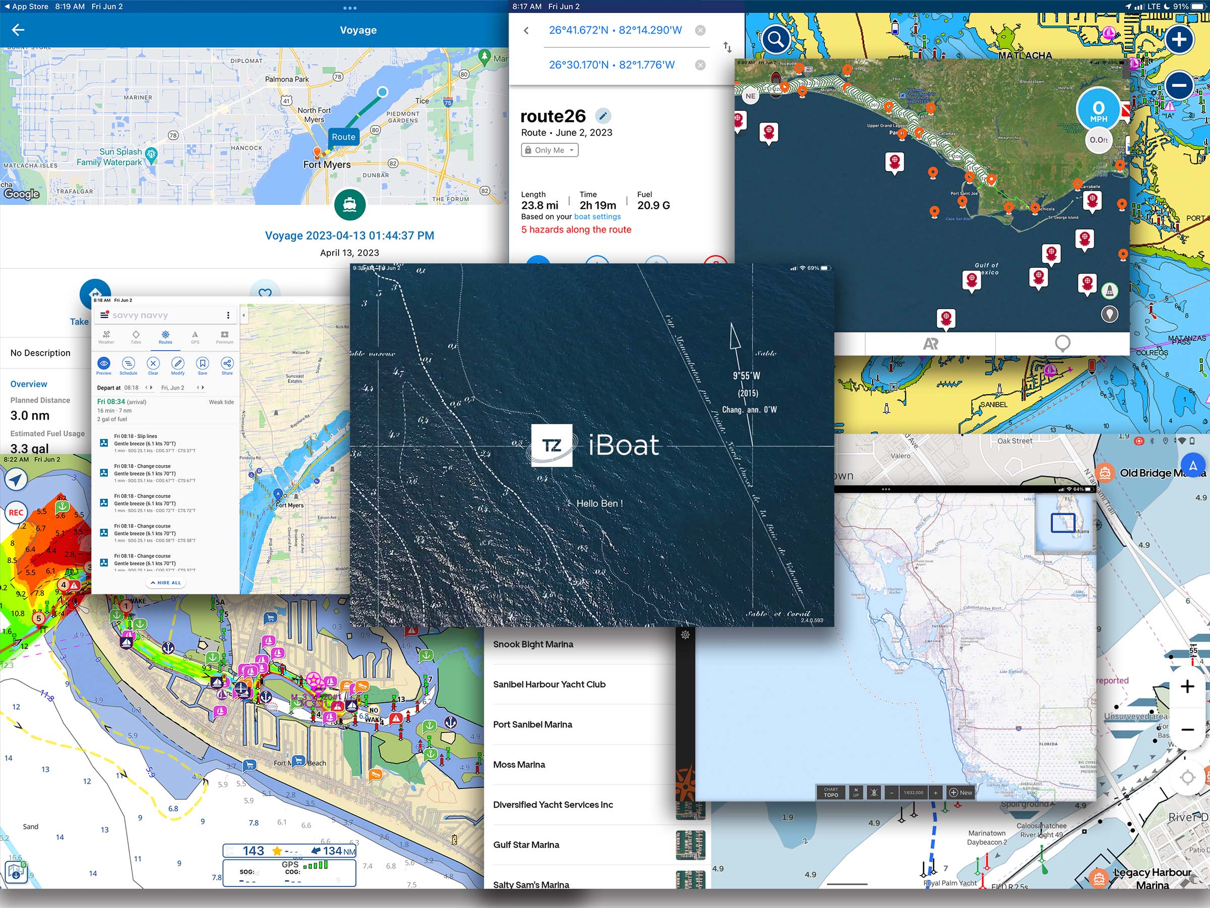
As something many of us already have, being able to use a general-purpose device for the purpose of navigating our boats is attractive. Many (most?) of us use our phones for car navigation, so it’s a natural extension to use a phone or tablet to navigate a boat. In fact, I’ve lost count of the number of marine mobile navigation apps that promise to be Google Maps or Waze for the water. I’ve had on-the-water experience with Aqua Map, Argo, Coastal Explorer, iNavX, Know Wake, Navionics, Orca, Savvy Navvy, TZ iBoat, and surely more I’m forgetting. Each offers unique features and advantages, but none have reached the ubiquity of Google Maps.
Cost-effectiveness
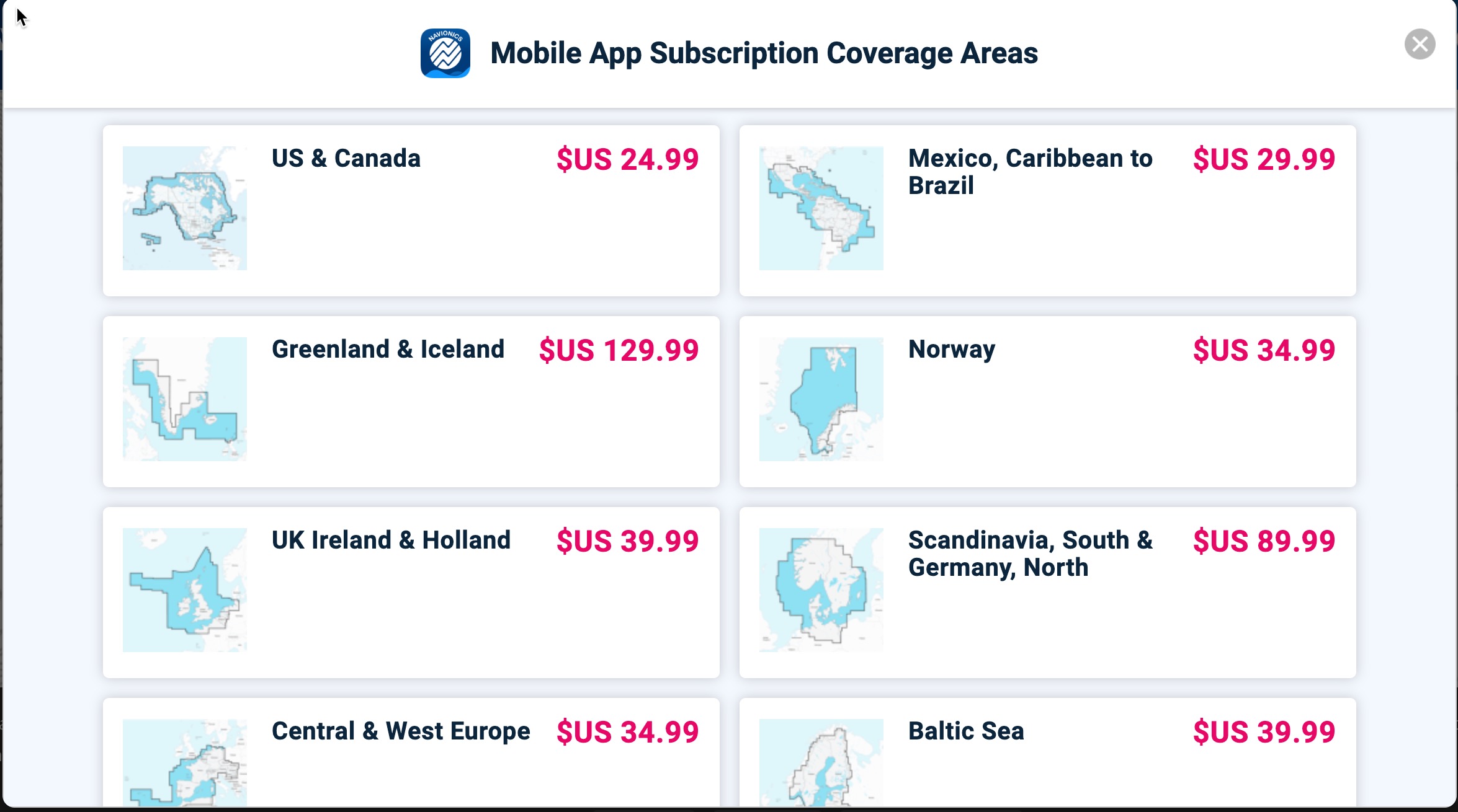
Compared to traditional installed navigation equipment, tablets offer several advantages. Often, the single largest advantage is affordability. Several of the most popular tablet navigation packages offer annual subscriptions with continental coverage for just twenty to thirty dollars. Navionic’s Boating app is $24.99 for the U.S. and Canada and similarly priced for other regions. Aqua Map’s U.S. and Canada subscription is $14.99 per year or $39.99 for a perpetual license. With prices quite low, it’s also feasible to subscribe to and use multiple navigation apps.
Flexibility
One of the greatest benefits of tablet navigation is the ease with which a boater can switch from one app to another. I realize that sounds obvious, but compared to an installed chartplotter, it’s a major difference. With installed equipment, once you’ve made your purchasing choice, you’re committed. But, with a tablet, you can use different apps for different circumstances. For example, I think Aqua Map’s Master suite provides invaluable features for cruising the trouble spots of the ICW. But, if you’re in open water, you may prefer another app.
I advocate the use of tablets as supplementary navigation devices to installed equipment. In this role, a boater can select an app that utilizes different charts than their navigation equipment. So, if your chart plotter is using Navionics charts, you wouldn’t want to run the Navionics Boating app and thus have two devices, both running Navionics charts.
Internet connectivity
Compared to an installed chart plotter, there are quite a few things tablets do as well, or better. For example, although several chartplotter manufacturers have implemented crowd-sourced data from Active Captain, I’ve always found the display and updating of that data easier and more intuitive in tablet apps.
Despite the inclusion of WiFi radios in most chart plotters for nearly a decade, the majority still don’t connect directly to the internet. As a result, access to updated charts, current weather data, and cruising information is limited or cumbersome. Tablet navigation apps provide easy access to crowd-sourced navigation information sources like Active Captain Community and Waterway Guide, plus easily updated weather and other information.
The downsides
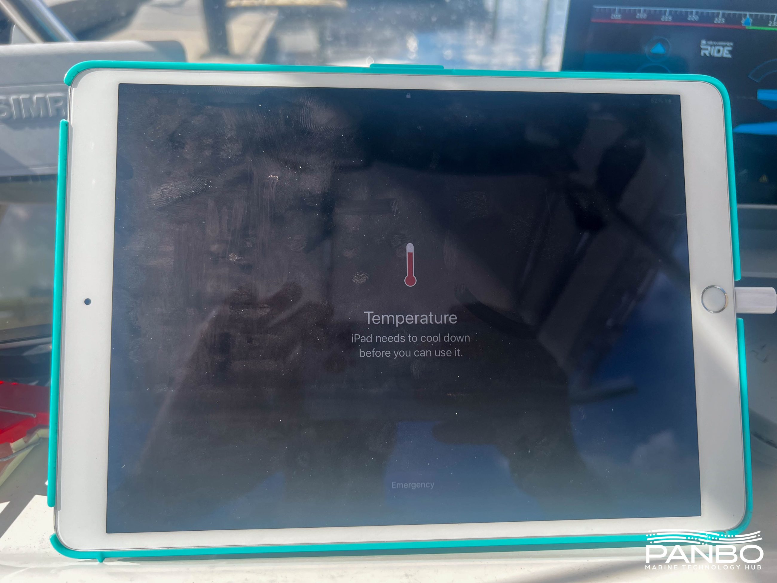
There’s a lot to be gained from a tablet running a navigation app. But, there are some limitations to tablets as well. In my opinion, the single largest concern is reliability. To my mind, there are three primary concerns, heat, power, and physical damage.
It used to be that tablet displays weren’t bright enough to be easily viewed in direct sunlight. Fortunately, most current tablet displays are plenty bright. But, they’re only bright enough when they are cool enough to run at full brightness. In my experience, iPads and Android tablets struggle to cool themselves on warm, sunny days and may shut themselves down. Even before that happens, the displays will dim and the processors will run more slowly.
Running at full brightness, tablets are power-hungry. Keeping up with their power needs requires high-output chargers. Even, with a powerful charger, the batteries can discharge while connected to a charger. The newest tablets, that rely on USB-C power seem to manage charge better.
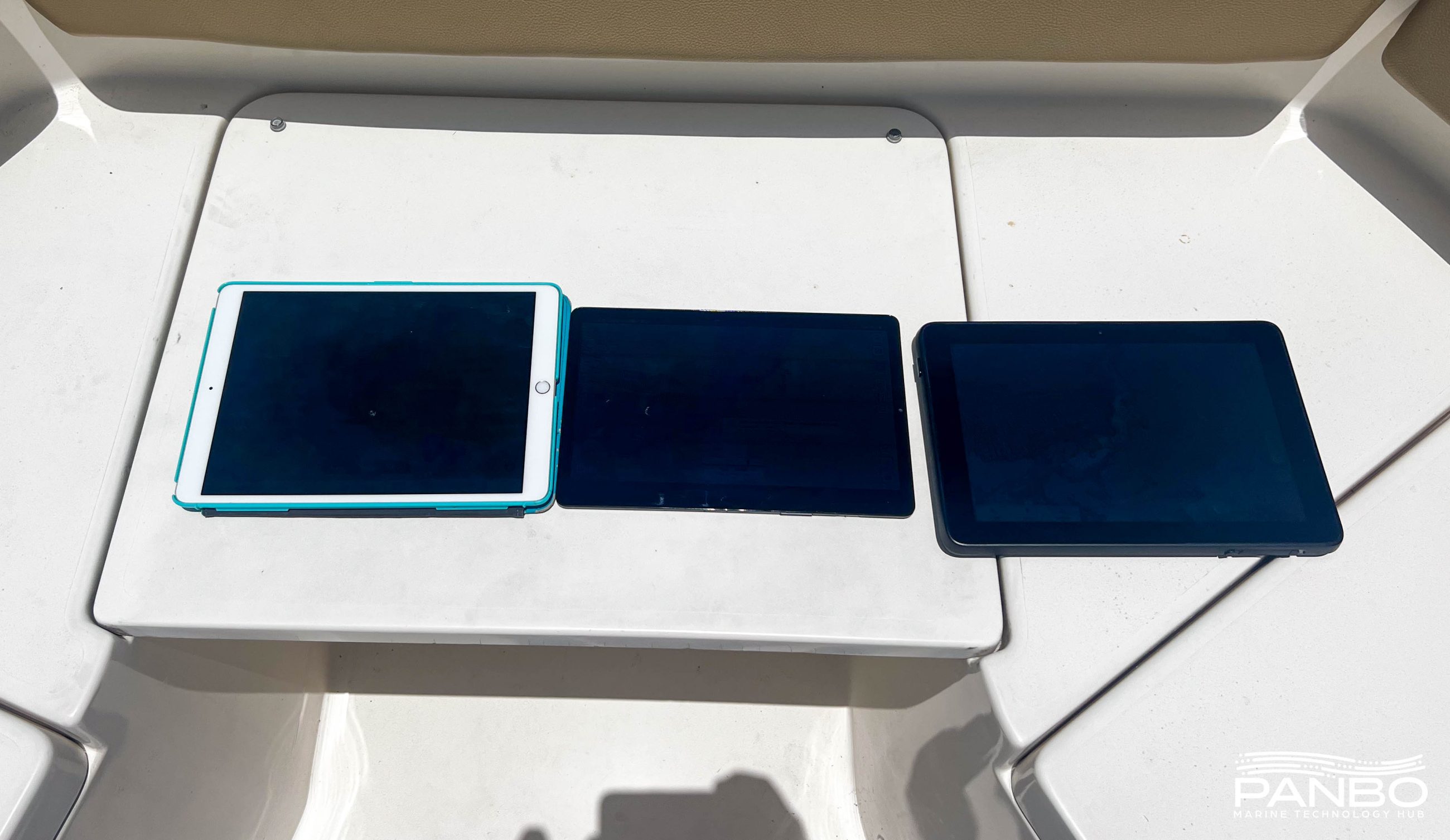
Lastly, unlike installed equipment, tablets aren’t meant to be permanently mounted. So, we need to find a way to secure the tablet. Cases, like the one my iPad is sitting in above, can help protect the device. But, it also serves to hold some heat in, making the cooling problem more difficult. On Have Another Day I never found securing the tablet too difficult. In contrast, Panbo(at)‘s ride is rougher and I’ve definitely tossed my iPad a time or two.
Tablets also don’t have NMEA 2000 interfaces or other marine-specific connectivity. WiFi gateways allow us to connect our tablets to a marine network, though at the expense of a little more cost and complexity. Additionally, except for TZ iBoat, tablet navigation apps are typically limited to chart plotter functionality, depth sounding, and AIS display. Radar and high-end sonar systems still typically require brand-matching displays from marine electronics manufacturers.
Do the advantages outweigh the disadvantages?
I’ve talked quite a bit about the plusses and minuses of tablets. But, what does all this mean? Should you use a tablet to navigate your boat? Let’s break it down a little further. I firmly believe there is a place for tablets and phones in navigation. The only outstanding question in my mind is, should I replace my installed navigation electronics with a tablet? Things are getting better, but I just don’t think we’re quite there yet.
Supplemental navigation
In this use case, a tablet is used to augment the existing navigation equipment on a boat. I am and have long been an enthusiastic advocate of using a tablet to supplement your navigation electronics. In a supplemental role, the advantages of both a tablet and installed equipment can be fully realized. As I mentioned above, I think supplementing installed equipment with a tablet is a no-brainer. You get all the benefits I mentioned above, and if you should encounter some of the weaknesses, you still have your installed equipment ready to go.
Primary navigation
In terms of features and functionality, I think tablet navigation apps do an excellent job and are capable of safely navigating your boat wherever you may want to go. But, the reliability of tablets in this role still isn’t where I would want it to be for a cruising boat. If you’re making day trips in familiar waters, tablets are a fine option. If you have older installed electronics that work, but a tablet provides a better experience, I think that makes a lot of sense.
There are some ruggedized tablets that are made to operate in these conditions and those seem like a good fit. In fact, I’ve been testing Orca’s Display 2, a tablet made for the purpose. A lively conversation in the comments section of the Orca Display 2 press release is part of the inspiration for this entry.
A purpose-built tablet might just be the answer. When Apple, Samsung, and other makers of general-purpose tablets design them, they make them thin, light, and attractive to as broad an audience as possible. Thin and light are often the enemy of heat resistance and durability. But, while Orca’s Display 2 seems to be a great tablet, it’s part of a larger offering from Orca with their Core and apps. It probably wouldn’t make sense to buy an Orca Display 2 to use exclusively with another navigation app.
Final thoughts
The decision about how to outfit and equip your boat is one of personal preference and comfort. Mariners safely navigated long before GPS, Loran, or other technological aids. It can be done and it can be done safely. There are plenty of experienced cruisers safely navigating their boats with mobile devices. On the other hand, I’ve come across new cruisers who have had some white-knuckled experiences courtesy of reliance on mobile devices and ill-timed problems. So, we all have to figure out what works for us, our boat, and our experience. I’d love to hear from you about what you’re using and how you’ve made it work for you. I’m also well aware that I haven’t captured all of the potential advantages or disadvantages of tablet navigation. So, if you have more to add there, I’d love to hear that as well.


One of the pluses for tablets is higher resolution graphics. My chartplotter can’t hold a candle to the iPad.
Leonard, no doubt iPads (and other tablets) have higher-resolution displays. But, the largest iPad display is 12.9″ whereas chart plotters get up to the mid-twenty inches. And while I think those displays beg for higher resolution than their 1920×1080 or 1920×1200, at typical chart plotter viewing distances, I believe much of that higher resolution is wasted.
-Ben S.
I agree the apps are great for planning however to use a s a sole source for navigation is dangerous. Recently in the Bahamas using Navionics and AquaMaps with Starlink the app firmly put the position of my vessel in downtown Atlanta. While this corrected itself within 10 seconds it is disconcerting the position was that far off for shallow water positioning.
Were you using the tablet’s internal GPS? Rather than connect via WiFi to your Starlink AP, maybe connect to a WiFi gateway on your NMEA network so you can use your vessel’s GPS? But I agree, I would not use the tablet as my only source of navigation.
Hello Ben
We have sold our Loop boat Zoeys Adventure and presently living in Kent Island,MD and have a 33 Ft Nauset, Knot Again, to explore the Chesapeake Bay.
Just like on the Loop boat I ran both Garmin and a Ipad with Navionics. Never have I had any issues with the IPad . I personally fine Navionics to be easier to operate.
My question is when do you think Navionics and the IPad will connect and drive an autopilot?
Hope you and your family are well.
All the best.
Rene,
Good to hear from you. I expect that Navionics (especially in light of their Garmin ownership) will be late with autopilot support (if at all). It doesn’t really serve Garmin’s business interests to potentially displace their installed equipment.
Currently, the apps I know of that support APs are iNavX, Orca, and OpenCPN.
-Ben S.
Yep. That’s why I will stay with my Garmin Chartlotter, updated frequently through the Active Captain app. It’s important to me to be able to control my autopilot from the chart plotter with my routes, tracks and active captain content right there, all from the same screen. Safe,
positive and convenient. Tablet alone can’t do that.
Personally I prefer not to have a plotter to AP interface. The plotter will tell you the course. Steer the boat on that heading and press engage. The gps will tell you if you are off course. Make corrections as needed. This way the navigator/watch stander are aware of set, drift and leeway. It takes almost no effort and keeps the humans engaged. It also prevents those awkward 90 degree turns when the gps/AP interface has a glitch.
Ben, I have SIMRAD displays: one runs Navionics, the other C-Map. I upgraded by electronics in 2017 for the price of a small Mercedes! But I bought an iPad for my trip from FL to Annapolis. I had been enlightened to the capability of Aqua Map with the USACE overlay for the ICW. Wow! How cool! This weekend I used Aqua Map again to transit Knapps Narrows on the Chesapeake. Spot on! It showed when to ignore the ATONs to find good water. So, I now use BOTH chartplotters and iPad.
Final note: please remember to note that you must buy the cellular-capable iPad to get GPS. Many still make this mistake.
Thanks for the work you do!
Bob Smith
M/V MARY KATHRYN
Hatteras 58 LRC Annapolis
Yeah AquaMap is a great value with frequent map updates, USACE overlays, USCG LNM’s charted, weather forecasts, remote anchor monitoring… and if you have a WiFi gateway on your NMEA network you can show additional data on the app.
Had two iPad Pro’s 12,9″ already 4 years now, excellent value. Full European GSM coverage, 20 eur/month unlimited data.
One in Otterbox for protection, the other one loaded with identical app’s: general purpose, backup, mail, internet.
Never wanted to have a chartplotter, you mentioned the reasons already. Old Furuno radar still doing its job well.
Heat is indeed a problem, but since we sail in moderate climate most of the time it’s OK.
Vulnerability of the power plug, USB-C seems better.
Very topical, Ben! Our (now antique) e95 helm chartplotter is fading fast – I am pretty sure the next saltwater splash it gets will finish it off. Replacing it with Raymarine Axiom Pro 2 (which would fit the helm console) will set us back at least three boat bux. We’ve been looking at all sorts of alternatives, but a couple things have created difficulties – the biggest of which is radar integration. Nothing I’ve seen will allow us to view our radar at the helm besides a dedicated chartplotter. The rest of the data aboard (wind, speed, depth, GPS, AIS and the like) can be conveyed to a tablet, but the radar is a real issue.
We have a 10Hz GPS on our N2K buss, is a tablet and its aps able to disregard its own internal GPS to use an incoming GPS data stream?
Hartley
S/V Atsa
Hartley – yes you can take advantage of your ship’s superior GPS (refresh rate, likely better view of the sky) by connecting the smartphone to a WiFi gateway on the N2K bus. In the example of AquaMap, here is a link that describes how to do this along with some tested WiFi gateway hardware brands. I do this for both Aqua Map and Navionics on our s/v. https://www.aquamap.app/support/17-master-features/35-wifi-connections
Thanks, Ted! I checked out that page, and the accompanying list of known compatible devices. Sadly, almost half came up 404 (or similar). I note that one needs to send AquaMap either NMEA0183 or Signal K data, so the interface (in our case) needs to translate from the N2K buss to one of these formats. To my eye, the Digital Yacht iKommunicate device is the most reasonably-priced option, though it locks me into an iThing since the Android version of AquaMap doesn’t accept Signal K.
I REALLY like AquaMap, and I’m willing to stay with Apple (sorry, Orca!) but its amazing how quickly the possibilities start limiting themselves..
Hartley
YW! One WiFi Gateway not listed on that page but is included in the actual list of devices in the AquaMap app is the Actisense W2K-1. I just installed it yesterday to replace my Vesper Vision’s built in WiFi gateway and don’t have it fully operational yet. But I was able to verify that the Actisense does not truncate the depth data at the tenth’s decimal place like the Vesper does.
Interesting, Ted – does the W2K-1 have a way of connecting to our existing Wifi network so I don’t have to chose a source?
Hartley
Hartley, yes the W2K-1 can connect to your existing WiFi network. In fact, it can do that and also be an access point at the same time, and in my experience is a full-featured N2K WiFi gateway: https://actisense.com/products/w2k-1-nmea-2000-wifi-gateway/
And to further confuse anyone’s search for boat data over WiFi, there are two other gateways I can think of that aren’t on Aquamap’s list:
#1 (and fairly obvious) is the Garmin Vesper Cortex, which can multiplex many 0183 and N2K data types to each other and stream all to nav apps including its own AIS, Heading and precision GPS.
#2 For many years Simrad MFDs have been able to stream boat data over their built-in WiFi, which can alternately connect to boat router. I don’t know if the new NX models include the feature, but various Evo models I tested could do it, and the inexpensive little GO5 XSE on Gizmo still can.
Ahh – yes, I discovered the W2K-1 manual just a bit ago and I see it has a client mode. I’m beginning to think that may be the way to go at least for now, as the price is reasonable and the flexibility high 🙂
Hartley
Digital Yacht hasn’t updated the iKommunicate in quite some time and I think the product has been pretty much left behind. I had some stability issues with mine that I wasn’t able to resolve.
I believe at this point the NavLink2 is Digital Yacht’s current NMEA 2000 to WiFi gateway – https://digitalyachtamerica.com/product/navlink2/.
I’ve also had good luck with the Actisense W2K-1 and the Yacht Devices YDWG (full disclosure: I own the U.S. reseller of Yacht Devices’ products).
-Ben S.
Ben, you jogged my memory – I already have a YDWG-02R (Ver 1.10 firmware) I bought a couple years ago. I didn’t figure out how to make it play with my iPhone then, but it works like a champ now (the Admiral is happy – she LOVES the AIS!). The only thing I couldn’t make it do was update its firmware, it seems to be stuck on 1.10. Now I have to open up the nav station and plug it into the very last remaining open port.
Thanks for the reminder!
Hartley
Hartley, Furuno does offer the DRS4W WiFi radome. It’s fairly low spec, especially compared to Furuno NXT, but it does integrate nicely with what’s now called TimeZero iBoat:
https://panbo.com/nobeltec-timezero-app-2015-furuno-drs4w-wifi-radar-overlay-more/
https://mytimezero.com/tz-iboat/
With or without the radar module, iBoat can connect with streaming 0183 boat data — which is the norm over WiFi, even if N2K is the source. But the real star in that department is the relatively new and under appreciated Coastal Explorer app, see screens at end of this entry:
https://panbo.com/coastal-explorer-app-for-ipads-iphones/
Hi Ben! Sigh… it is probably just me, but its discouraging how quickly the options diminish as soon as you start making choices. The Furuno WiFi Radar looks neat – but it doesn’t play with anyone else’s charting or aps. Coastal Explorer is a fun little ap, but doesn’t have AquaMap’s features, and charting is pricey at $50/year for the US.
The iKommunicate device would bring my N2K data to my iThings, and at under $300, not exhorbitantly expensive. It would plug directly into my onboard WiFi system, so no cable pulling and standing on my head 🙂 But the solution to our expiring chartplotter is not clear, alas.
Hartley
Yes, so many ways to skin this cat! In fact, iKommunicate reminds me that you might be able to get your Raymarine radar on your iPad…
https://panbo.com/wilhelmsk-app-shows-what-signal-k-good-boat-wifi-and-smart-diy-coding-can-do/
… though I think the preferred method is with a SignalK server.
Hmm.. Our e95 has built-in wifi that I can connect a Ray ap to and see the screen – radar and all – but that does me little good if the e95 is in la-la land because it got splashed 🙂 I would really rather replace the e85 entirely, though I suppose I could move it down below out of saltwater danger.
That iKommunicate device has been around a while!
Hartley
Nice summary Ben. I’m a big fan of tablet based navigation apps (AquaMap, Navionics and IBoat) as an adjunct to my Furuno TZT3 at the helm station in the cockpit of our s/v. That said, I’ve experienced the heat related issues mentioned by Ben, as well as being in squally conditions where the touch screen on the iPad became useless.
Hey Ben,
Great post. Back in the day when I did the loop (and you were there) one could get an iPad that didn’t have internal GPS or get one that did. Fortunately I got the one that did by luck and not by design. Anyway, I have been at 38,000 feet in a window seat and been able to hold my iPad up and get a satellite signal that allows me to track the progress of the plane. I was certainly out of cell phone range.
I believe that if one gets an IPad that doesn’t have internal GPS abilities then if you’re out of cell phone range it doesn’t work? Is this correct ?
On our loop we had 2 IPhones, and 2 IPads as “backups” to our Garmin chart plotter. More computing power than all Apollo missions combined. As I progressed I found myself using the IPad w/ Navionics more and more frequently. Resolution and detail of depth markings seemed far superior. We only touched bottom in the notorious Barnegat inlet despite it being my home waters, LOL.
The Garmin became the radar and AIS display.
One addition advantage of having the iPad is the ability to use it to Wi-Fi update Garmin Active Captain maps and data, which I did frequently. It becomes a simple task with the IPad linked to the Garmin Wi-Fi.
“I believe that if one gets an IPad that doesn’t have internal GPS abilities then if you’re out of cell phone range it doesn’t work? Is this correct?” Hmmm, I used to hear that iThings with GPS and cellular — they come together — could not determine position well without cellular assistance, but I believe it was a myth (as you saw in the plane). I’ve used iPads without GPS or cellular for many years by streaming boat data over WiFi and many nav apps can use or display GPS, Depth, STW, Heading, AIS and more. Without boat data, my iPads try to determine location via known WiFi access points but that’s certainly vague, especially on the water. I also have a Bluetooth GPS that works with my iPads.
https://support.apple.com/en-us/HT203080
Having watched my iPhone mapping when it wakes up its internal GPS, what I’ve seen it do is initially set my location to the location of the cell site its linked/listening to, followed by it jumping ever closer to the correct GPS position. This “feature” tells me where those cells are, which can be handy!
Hartley
John,
You’re quite correct that a WiFi only iPad doesn’t have an internal GNSS receiver. So, in or out of internet range it won’t be able to gain an accurate position unless it’s using an external GPS receiver via Bluetooth or WiFi (using one of the WiFi gateways mentioned).
On the flipside, if the iPad is cellular equipped, it will also have a GNSS receiver. There doesn’t need to be an active rate plan on the device and it doesn’t need to be in range. It just needs to be a cellular model so that it’s equipped with a receiver.
-Ben S.
I’m glad that I actually got some thing correct. So do todays iPads have an option for purchase with or without cellular? It would be important in my opinion to get the cellular equipped device even if no plan is activated. I plan on replacing my current iPad in the very near future.
Exactly right John. I always recommend buying the cellular-equipped iPad, even if you’re not going to activate the service. I still think that’s advisable even if you plan to use a WiFi gateway. The built-in GNSS gives you a backup to the WiFi gateway if you lose connectivity for any reason.
-Ben S.
Hi Ben,
I used multiple devices and different Catographies during our cruise up the UMR to Minneapolis. I was curious as to accuracies and coverages. These were Rosepoints coastal explorer, Garmin, Navionics, nobetec, cmaps and associated paper charting and Army Corps sourced books. . Note this was pre Aqua Maps. I was impressed that at that time navionics sonar charts included the greatest and most accurate detail. Garmin was incredibly deficit in detail and up to date data as were the others.. Note this is now certainly dated information and not valid today. In all our travels I used multiple sources especially on inland rivers and waterways.
Warmest regards to the family. ( and you also)
What is your take on using OpenCPN on tablets?
Jim, I’ve only dabbled with OpenCPN but it looks like it’s evolved nicely over the years, including support for Android tablets, which means that maybe Ben Stein can try it on the Samsung tablet pictured above. :
https://opencpn.org/wiki/dokuwiki/doku.php?id=opencpn:opencpn_user_manual:getting_started:touch_screen_tablets
Also, I think that one of the most impressive aspects of OpenCPN is plugin support for several radar models:
https://opencpn.org/wiki/dokuwiki/doku.php?id=opencpn:opencpn_user_manual:plugins:ais_radar:radar
So it seems possible that a ruggedized Windows tablet with an Ethernet port (like several on Amazon) could put radar and charting at a helm almost wirelessly.
https://www.amazon.com/GHKJOK-Ethernet-Removable-Sunlight-Readable/dp/B0BRRTMFH9/
I’m in a similar situation to Ben Ellison having only dabbled with OpenCPN. I’m planning on a tablet app roundup this summer and I’ll definitely add OpenCPN to the list.
-Ben S.
To Both Bens,
Thanks for the info. Will really appreciate y’all’s thoughts on OpenCPN. I purchased over the years two different refurbished rugged Dell Latitude laptops that can be used as tablets, a 7202 & a 7220. Both have hot swappable batteries. Haven’t taken them out on an extended trip yet. They both have the older Polar Navy & OpenCPN installed. They receive wireless data from a Vesper Watch Mate Vision XB9000. The Vesper receives NMEA 0183 data from various sensors & sources. So far, I’ve been happy with the setup. I like the portability to have a screen with me wherever I move to.
I am aware of several people in small boats who have done the “Great Loop” using only I phones for their navigation, and no chart plotter.
I used the I pad as a supplement with Aqua Maps along with chart plotters with Navionics for many river trips. The Aqua Maps were great for planning. Also a few times when I was in fog, my first mate watched the Radar (Raymarine Axiom Quantum)on the I pad vi wifi. I had eyes on the water and chart plotter, which was a handy combination for inland waters and COE charts.
Wow, what great responses! I’ve been in the French Quarter of New Orleans with my family and watching the comments roll in. The one faction we haven’t heard from is anyone using their tablet as their primary navigation. I know there are people out there for whom that works. I’d love to hear about your setup.
-Ben S.
Laissez le bon temps rouler
There was a response from Egenolf who sails without plotter and so do I. I never owned a plotter and will not. Rather spend the money otherwise and I hardly sail by waypoints; usually we keep just the destination waypoint and navigate by good old eyeballing and keeping track of our position on the iPad. I sailed the Biscay and North Sea with an iPad Pro with cellular, AIS plotted thru wifi. To me the great advantage is that I can do trip planning and evaluation at home. Plus the advantage of having a choice of maps; we have a Hydrographic Office with it sown charts in each West-European country, and for instance in French waters the French charts are unsurpassed. In addition, I would want to have an iPad anyway.
I agree to the heat issue, I had shutdowns from overheating is direct sunlight. Otherwise I always keep it shaded under the dodger, also because the brightness is not as good as a chart plotter.
Hi Ben!
A bit astonished that you says nothing about the SailProof tablets, specially dedicated to boaters. 8 and 10 inch android tablets, rugged, waterproof, sunlight readable (1000 nits), with a big battery (10,000 mah) and an accurate GNSS chip. Have a look 😉
Thx for the excellent summary.
As a matter of principle I agree but I use a tablet (iPad) as additional/secondary device in the cockpit where & when required, the nav station has a dedicated PC/plotter software solution. We don’t operate a dedicated plotter of the major brands.
I contemplated moving away from the iPad to a rugged table (see https://sailproof.shop/de/) but did not want to deal with another OS which wouldn’t run some apps available for IOS. Likely a good product though.
The wide variety of apps available is a pro, however there is little quality control on what an app really does and how well it works for nav purposes. So I don’t trust some products which are rushed to the market by their developers.
Some more products are used over here in N-Europe, notably NV charts mirroring their printed charts which is a plus with respect to the GUI.
Just wanted to share
My iPad experience, I’m one of the ones who bought an iPad without gps on accident. I connect it to my YDWG-02 and it works great! And the interesting thing I just thought of is I haven’t dealt with overheating issues experienced by others, and I’ve been cruising Central America having just arrived in Cartagena yesterday where it is really hot! Maybe the iPad doesn’t work as hard because it doesn’t have internal gps?
The SailProof tablets look good, and I’m pleased to see that they’ve chosen ScanStrut ROK Mini mounts as their solution to the significant issue of keeping a tablet where you want it underway. I’m still happily using the easel-style iPad mount on Gizmo, and also now on Junior where it’s still solid at bumpy high speeds.
https://panbo.com/scanstrut-rokk-mini-premium-marine-mount-system/
But I’m quite intrigued with Orca’s Display 2 sleeve mount which also solves the problem of charging in harsh conditions with a 25W wireless pad. I somewhat wish they’d chosen ROKK gear for attaching the sleeve to the boat, but the RAM system used is also good. The waterproof fast charging sleeve can also be flush mounted or mast mounted using a standard VESA pattern bracket. Seems slick:
https://getorca.com/orca-display-2/
Found more detail on the Orca charging mount and it’s quite impressive:
https://getorca.com/blog/orca_display_2_mount/
> It probably wouldn’t make sense to buy an Orca Display 2 to use exclusively with another navigation app.
Hi Ben, Curios why you say this? I was considering this very thing.
The Orca tablet is definitely designed to be used with Orca’s app. Rather than utilizing a traditional Android launcher, it automatically launches the Orca app. To use other apps, you navigate through Orca to the menu and then select apps. I think it’s a reasonable solution for a tablet designed to be used with their app, but it’s not ideal if you’re planning to use something else.
-Ben S.
I’m someone who does use an iPad for navigation on deck, without a plotter on deck. I mainly cruise the English Channel area, on my 43’ Swan dating from 1989. I don’t have a plotter on deck, partly for aesthetics, and partly because I don’t like them at the wheel – too often it lures the helm into staring at the plotter rather than looking where they are going. I’m all too aware others have different, near religious, views, but as an old yachtmaster instructor and offshore racer it’s a compromise I’m comfortable with.
We sail short handed, usually 2 up, and usually have a 12.9” WiFi only iPad in the cockpit, connected to the boat’s instruments (B&GH2000 with fastnet to n2k gateway and autopilot, Vesper WatchMate 8000, B&G N2K GPS, VHF etc ) via WiFi . At the nav station is a laptop running expedition, which dumps some of its data out to B&G deck displays (5×2020 at the mast, and a further 3 two line FFD numeric displays in the cockpit) or to the iPad via either NMEA Remote (a great app, esp with the expedition integration) or using MS Remote Desktop. The primary nav app on deck is, however TZ iBoat. There is an old furuno plotter below deck, but that is almost exclusively used just as radar.
At some point I’ll upgrade the radar and plotter to a new Doppler system, probably B&G, and will aim to use the iPad as an on deck display as not having radar on deck is a pain in restricted vis. There is a spot at the front of our cockpit, currently occupied by 3 B&G analogue displays and two FFDs that could accommodate a plotter, but at the moment I’d rather spend the money on a watermaker and use the iPad!
The combination of C-MAP 4D charting in expedition and the option to have either vector or raster charting in iBoat provides all I need. The formal passage planning gets done in expedition, but the situational awareness, AIS monitoring, pilotage etc is done in iBoat. It works well in combination. We do have another older iPad below decks ready to step in whilst the newer one is recharged. I’ve found remembering to put the iPad down screen to the bulkhead in the cockpit helps no end with the overheat problem. A paper log is kept below, and reasonably comprehensive, if un-corrected paper charts are buried in the chart table.
I’m also interested to hear others views – though I’m guessing that this audience is likely to be very pro-tech!
Our installation is close to yours for an 38-footer, tiller steered. We have a set of high quality sensors (ultrasonic wind by LCJ capteur, airmar compass H2183, Cetrek Echo plus Airmar DST 810 for speed and temp, AIS transceiver for AIS and GPS. I always opt for standard pieces of equipment, thus I am not bound to one manufacturer and can exchange devices in case they fail or I decide to upgrade. No Radar though….
All data runs through multiplexer and converter where required and is then sent to displays and autopilot and with high speed to a nav PC with charting software (still chart navigator but in the middle of a change to an other package. PC gets internet where required via cell phone. A cheap R232-wifi server sends all data out to a tablet/iPad with chartings software. The PC is a once off model optimized for low power consumption, it doesn’t take an Amp even. Screen is a 12′ at the nav station. with 400 its, good enough inside.
The installation has the benefit to run under pretty much any standard, with any software to be used and with any tablet hardware and apps that are favorable. As we are tiller steered the tablet sits in a rugged case at the bulkhead in the cockpit in a holder, out of the sun for a great part of the day and still with access to power. In can be carried around if wanted but we only use it anyway when in close quarters. Prefer to watch what’s happening on the water rather than trying to get this from a screen…..
Like many, I too use an iPad with iNavx as a supplement to a MFD. I find it most convenient, and great for my aging eyes. What I think is important to mention is that we rely on our autopilot extensively, and that is only controlled via the MFD. Even if there were a tablet app that would control an AP, I would not trust a tablet to be as reliable as a MFD/AP for something as critical as driving the boat.
I used a Ram mount to place the IPad slightly above and to the side of the MFD. This allowed me to compare and contrast the IPad running Navionics with the Garmin MFD with just a glance. The Ram mount was rock solid and even straight into 4-5 footers crossing a rough Tampa Bay the Ram mount never failed to hold the IPad steady.
It was under a hard top so sunlight glare or overheating was not a problem and I installed a power outlet to keep it charged. It would suck down the battery life very very quickly if I forgot to plug it in and of course dying exactly right when I would need to bring up info on the correct name or clearance height of the upcoming bridge or lock we needed to pass. I found it much easier to get pertinent info from Navionics than off of the Garmin MFD.
With Garmin Active Captain linked via Wi-Fi I could actually control the system from the iPad and once or twice I did fool around with it on open water to see if it worked properly. It did work but like you I wasn’t comfortable and didn’t use those features routinely instead relying on the MFD.
I am currently considering another boat and if I take the plunge I will absolutely install a Ram mount to run a more current IPad along with the MFD. I’m excited to see Ben’s future review of Tablets and their capabilities and downsides in the future.
I cruise on one of the worlds busiest waters in the world (river Scheldt in the Netherlands) and regularly compare iPad Pro using SEAiq and many other apps, Microsoft Surface using Windows10+Coastal Explorer against a Garmin 722XS plotter connected to a NMEA2000 network. The latest available chart option for Garmin which are expensive, is dangerously outdated in being more than a year behind the free national weekly updates. When I use my cellphone as a hotspot to the ipad to display AIS targets in the SEAiq navigation app that is noticeably faster than the Garmin plotter connected to a top AIS transceiver EMTRAK B954. On the Garmin often commercial craft have already passed me in realtime before the Garmin plotter is able to show this on the screen. Yachts in the Ocean Race use tablets, you won’t find a much tougher environment for navigation equipment. If I had to choose between Garmin charts or even the very cheap Aqua Map yearly subscription for my iPad the choice would easily be to go for Aquamap on iPad. Any system easily beats the Garmin plotter set-up. Many providers to the leisure marine business have electronic charts as a very expensive business model but perform very poorly. The Garmin/Navionics brand being the worst of the better known brands. Before my retirement I was a professional merchant mariner for my entire working career, a master for over 25 years so I do consider myself knowledgeable enough to make a judgement on this theme.
Thanks for your 2 cents, but I’m quite baffled about how your Garmin and Emtrak system could be slower to plot AIS targets than what you’re seeing via online AIS stations. I’ve often had both forms of AIS on my boat, plus radar ARPA tracking, but have never seen that. In fact, I’ve often seen the opposite, where online AIS is slightly to seriously delayed and can only be used with great caution. Note that my testing has included SEAiq — which is very good, especially at AIS — and Garmin plotters. What could be so different on the river Scheldt?
I don’t know for sure Ben, I’m baffled too. I suspect the processor of the Garmin not to be the fastest. I was very much surprised as well that using the SEAiq app with the AIS feed through 4G cell phone hotspotted from my iPhone 12 mini to a ipad pro of 4 years old is smoother when passing fast merchant vessels or pleasure craft than the combination EMTRAk with Garmin. And I’m pretty sure EMTRAK is not to blame. Not enough memory?? Anyway that’s not my main complaint. The update frequency of Garmin charts in this area are a joke. When you buy a newly released 2023 for my area it is so far behind with the location of the sandbanks that it becomes dangerous. If there’s a way to post examples of the charts I’d be happy to do so. Pretty sure limiting their plotter use to their own chart system is part of a business plan. Hence my preference for SEAiq or Coastal Explorer with free official iENC’s for Dutch inshore/inland waters. Anyway the question was are tablets ready to replace plotters? I think that people will more frequently opt for good quality tablets to replace their plotters. They give you more choice in Navigational Apps, Chart resources, easier to use on different boats, can be used for any other app etc. Garmin also limits the use of their WiFi, no way you can connect another brand to their system. The mirroring of the screen in iPhone / iPad using the ActiveCaptain app is nice but is limited to exactly mirroring the plotter screen, can not create a second screen with a different layout etc. Garmin hardware has proven to me to be reliable in most cases but their software approach has a lot of room for improvement if compared to nowadays very well designed apps for tablets.
I have been using an iPad only for navigation since 2015 and the biggest issue for me is I cannot find a good case. Lifeproof Nuud used to make them for the pad air 2 with no flimsy screen protector which I still use since the newer iPad got wet and is shot. The one thing no one seems to mention here is the case situation which is the #1 issue. #2 Issue is that the charge cables which last around 1-2 weeks before they stop working. Ive tried every brand cheap and pricey. The USB power supplies connected to 12v are rarely powerful enough to charge the iPad while it’s being used at 100% brightness. Blue Seas Scanstrut ect, all week and nearly useless at 12w or whatever they are. I believe the USB-C versions may give more watts. We sail offshore and we get wet. Sadly we may have to bite the bullet and get a chart plotter in one of those ridiculous white plastic cases that are 3 times the size of the actual plotter.. I really dont want to do that. Navionics and Aqua Maps are way better than even the newest B&G to me. I dont think many people are going to buy into a proprietary system like Orca when there well aged apps like Navionics. Any updates on a good case?
I have used a Furuno Navnet totally integrated for ten years, and an iPad. I keep my iPad plugged in, in a teak frame. I use an Apple Pencil rather than my finger. I have also navigated the narrow passages of Penobscot Bay using my iphone at night. I decided I don’t like integrated systems as one key failure takes down radar, sounder, GPS etc etc so I have moved to independent equipment. Re cost of iPad, I also bought a microcomputer for about $250 which is more powerful than the iPad and actually it’s footprint is much smaller than an iPad. A 15″ display, small keyboard and mouse brings the entire cost to about $500, less than an iPad yet more powerful and able to use all the sophisticated navigation software. I plugged in a GPS module into the USB port. It is easier to upgrade, easier to use and now my main navigation equipment. The iPad is for guest to use for fun.
Ben, this might have been mentioned but even so, it bears mentioning again.
A tablet can not navigate the boat, unless you have the knowledge to adapt it to a myriad of network connections and other potential fail potential hookups.
I’ve just finished an 8yr Loop and my Garmin NAV suite with autopilot has driven most of the way. It has kept me in the channel avoiding a number of potential pitfalls and done it seamlessly. To me and my cruising the dedicated NAV setup is the way to go.
I do use a tablet to preplan a trip but when cruise time comes, I enter the destination into my 8616xsv and after clearing the marina set it to auto route and it takes over the driving. I am continually on watch for any issues but Garmin has gotten the system working so well it even drives down the middle going under bridges.
Maybe when a tablet has a NMEA 2000 port it MAY be ready to take a more dominant role on the bridge, but until then, preplanning still is a good job for that tool.
Tablets are even more useful if they can connect to wifi and receive NMEA information from a chartplotter.
I’ve tried to connect an Aquamap app running on an iPad to a Simrad NSS7 evo3 but haven’t been able to get it to work. Aquamap has a manual way to configure wifi connections but there is scant information available on how to do it. You need port numbers etc. that are not listed anywhere. Is there a procedure available on line? Has anyone got this to work?
Tom, I’ve gotten WiFi data streaming to work well with various evo2 models and with my current GO5, so I’m pretty sure it’s possible with your NSS. I recall that the IP address and port number you need are buried in the WiFi settings submenus, but may also show in the Link app. Also, my GO5 ip:port numbers are 192.168.76.1:5001, though the IP almost undoubtedly varies boat to boat, and sometimes changes if you modify the install.
I run Memory Map with full raster Admiralty Charts on a Huawei tablet for the last 4 years on the inside steering position. Used on the west coast of Scotland brilliant bit of kit with the built in GPS shows my heading. The big plus is the quality of the charts from the world’s leading cartographer. I get the annual chart updates for £25.
Any thoughts on an article checking out the newest Time Zero iBoat features and chart updates? I have been using that so far and it feels like they have really leapt into the future on both fronts – really looking forward for the TZ Charts to make their way to Furuno and TZ Pro.
Ben,
I was able to find IP and port numbers for the Simrad NSS7 evo3 to send wifi data. Simrad or AquaMap help centers were not able to provide connectivity info. Looking through the Simrad chartplotter sub menus (network/nmea0183/ethernet-wireless) I found that IP 192.168.76.1 and port 10110 will send wifi data from the Simrad chartplotter to AquaMap.
On a completely different topic (not sure where else to put this question). Thought I read somewhere on your vast website about the Simrad “Bus off TX 255” error. When this happens the chartplotter will not communicate on the NMEA2000 network. Network is ok and powered on with other units working, cable ok, etc. Any further info on this error? Is it an internal Simrad chartplotter malfunction? Anyone find a way to resolve this?
I bought my 36′ Albin Express Trawler 4 years ago with the knowledge that I would have to replace my Raymarine radar and Garmin chartplotter within a couple of seasons. Both died that first season, for different reasons, and I was forced to make some quick decisions. The shockingly high prices of a “traditional” set up forced me to go the tablet route and I am completely happy with this decision. It has actually been a liberating experience for me. Currently, I have a 10″ iPad with Cellular and wifi capabilities. Although I do not have the cellular plan, these versions are equipped with a GPS chip. As a result, I have great GPS coverage for my cruising area which consists of the Bay of Fundy to Long Island Sound. I rarely go offshore beyond 30 NM and have never had an issue. The primary app that I use is Navionics but I also have and use Aqua Maps and TZ iBoat. For radar, I have Furuno’s First Watch radar. Although it is marketed as an entry-level radar for smaller boats, it has never let me down and has far more features than the 1999 Raymarine set that it replaced. Additionally, I can “stream” to my iPad on the Furuno Marine Radar app as well as overlay it on the TZ iBoat app. I agree that tablets can overheat but I have a Samsung tablet that I hold in reserve as well as my iPhone. I am very happy with my decision to go this route. My bridge and pilothouse are clean and uncluttered, and I have never had an issue with reliability or accuracy.
On both chart plotters and tablet apps I have an issue with chart updates. It is almost always impossible to check the date of last correction. I have seen marina mapping in TZ maps of more than fifteen years old. If those easy things are not corrected, how about the other chart data? This issue is seldom mentioned, I think it deserves more attention.
The Danish Hydrographic Office has challenged the electronic charting app providers about this a number of years ago. They reminded them about the duty of each mariner to have up to date charts, but what if he cannot check how up to date his charts are? The Danes got no good responses, threatened to develop their own competing app but nothing happened.
The only app I know of that supplies the correction dates for its charts is the Imray Navigator app, it even does so each quarter. for each of the raster map they supply.
Ben, I read with much interest your article about tablets in the boating environment. As a USCG Master (100-ton) and certificated private pilot with land and seaplane ratings, I enjoyed your comments. The shift to tablets in General Aviation started many years ago, with apps such as WingX and Foreflight providing usefulness not available before (unless you had a panel mounted system$$$$$$$$$) for private pilots. Nowadays many use these tools even in a certificated full IFR (instrument flying conditions) equipped airplane. Furthermore, many commercial pilots use iPads for checklists and other operations. The FAA has a process to certify using Ipads in the cockpit environment.
I’ve been using an iPad and iPad mini for quite some time for both Marine and Aviation navigation. I agree with the cons…my only add con would be that most tablets are not rated for the marine environment…One of my iPads had “water inclusion” even though it was not directly exposed to water. Maybe it was condensation due to the elevated temp these devices operate in a high humidity environment. The ideal solution would be an IP86 or better compliant iPad!) Tim Cook…can you hear this?
Like you said, these are supplementary tools to increase situational awareness (term frequently used in aviation but equally applicable to boating!). I still have steam gauges in my plane and limited Nav tools (compass, charts) in my ’86 Carver cruiser. I just installed a Furuno wireless radar integrated with TZ iBoat. I keep one iPad unit on TZi Boat with the radar overlay and the other displaying Navionics. But my eyes are my main radar detector in our very busy PNW waters.
Nevertheless, tablets do have a place in boating to significantly increase your margin of safety and leverage the increasing use of social interaction amongst boaters. Plus, can a Garmin or Raymarine display allow one of your grandkids to play Roblox while at anchor?
Keep up the great work!
Best,
Sailorbanker
I am considering using an Orca Core 2 with my iPad as the
Autorouting seems quite good. Is it possible that it will also integrate with my Garmin autopilot to follow that route?
At the moment, as far as I know and experienced, it can follow a heading. No sailing functions like AWA, TWA, tacking/jibing yet. But for sure this will be on the todo list.
HI,
Panbo loves Aquamap, so maybe you have a solution to this problem:
https://www.cruisersforum.com/forums/f121/anyone-have-to-re-download-aquamaps-charts-211396-2.html
So this is about the charts vanishing. Yes, downloading is possible, but not when underway. Is this an Apple problem? Is there any solution? Thanks!
Ummm, that thread was last posted on in July of 2020, nearly four years ago. I haven’t heard any reports of disappearing charts anytime recently. But, we review quite a few products and aren’t nearly as updated as the support organizations for those products.
-Ben S.
I know — I was very surprised to find it. And very surprised that it happened. That you have heard/experienced nothing is good news. I guess I can only hope it does not happen again. I did write Aquamap too. Thanks! JM
I know this is a really old post but I’m hoping that someone that has commented on it has an answer.
We need to replace our 4th gen ipad pro that we use for qtVlm at our (covered) helm to complement our now dying B&G Zeus 2.
The biggest issue we have is viewing the iPad during the day. It doesn’t get bright enough and has a lot of glare.
We’re in the south pacific and can’t view tablets in person so we need to pick one and have a family member bring it when they visit.
I’m trying to decide between the Samsung Galaxy Tab S9 Ultra and the new iPad M4 Pro with the nano-texture screen.
Had anyone seen these screens in person outdoors?
I haven’t used those but we have been sailing offshore with a Sailproof Tablet for a year+ which has been very visible in daytime. It’s not perfect but has worked well and has a large battery.