
Chart wars? Post acquisitions, what’s the status of charts?
It’s been four and a half years since Garmin bought Navionics and just under four years since Navico and C-Map’s corporate parents merged them. In both cases, there were statements made promising continued availability of the data on competing brands. But, would it? I’ve read comments from and talked to many boaters who are understandably nervous about access to their chart provider of choice on their navigation equipment brand of choice.
The first couple of years of the new corporate structures resulted in few changes. But recently, I’ve started hearing more and more about changes to discount levels, existing contracts not being renewed, and new products being unveiled with questionable availability to the rest of the industry. Heck, until a recent release, Garmin MFDs still didn’t use Navionics presentation, daily update engines, auto-routing, and more.
It’s been my hope that Garmin would follow the path they laid with Fusion Audio. Garmin realized that part of Fusion’s success comes from working with all electronics packages found on boats. So, they kept Fusion a separate brand and successfully maintained compatibility and good relations with the other electronics makers. Unfortunately, recent developments seem to suggest that’s not the case.
Navionics on TimeZero
A flurry of recent comments on an article about the introduction of Furuno’s TimeZero Touch 3 signaled a change in the availability of Navionics data on the Furuno TimeZero platform. I was surprised to learn that Navionics data would no longer be available on any of the TimeZero platforms. This includes both Furuno hardware and TimeZero software.
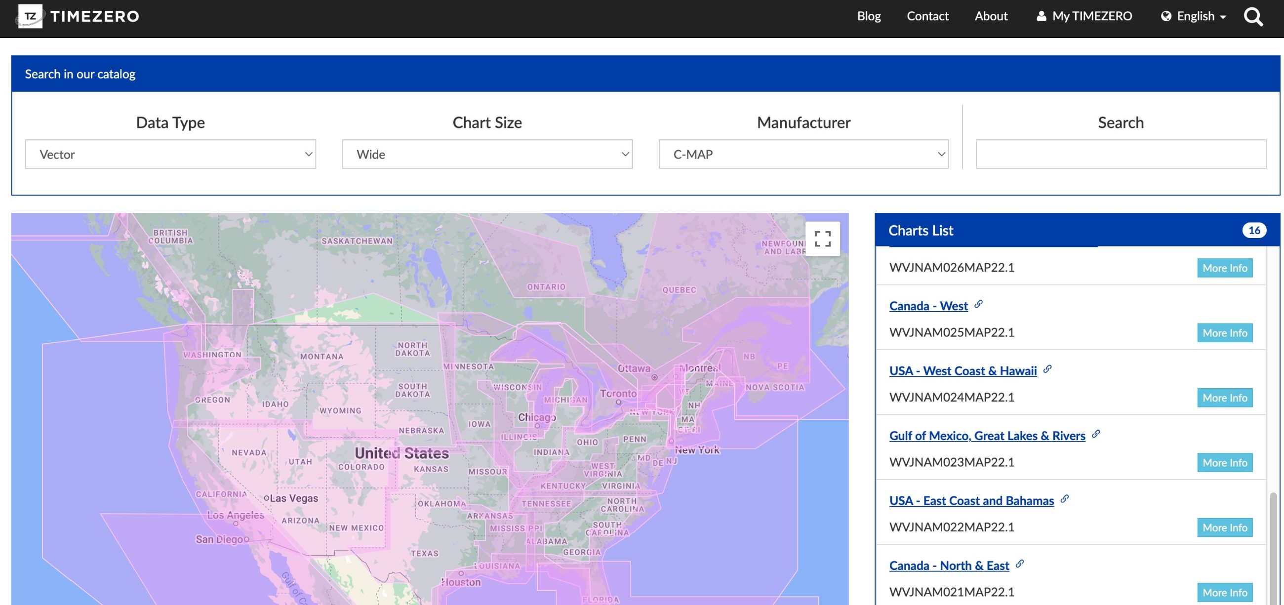
TimeZero uses the MM3D format from MapMedia. MapMedia is a corporate sibling of Furuno’s and this format is proprietary to them. All chart formats available on TimeZero are converted to MM3D for use on their products. This includes C-Map, Explorer Charts, CMOR, NOAA charts, and until recently, Navionics.
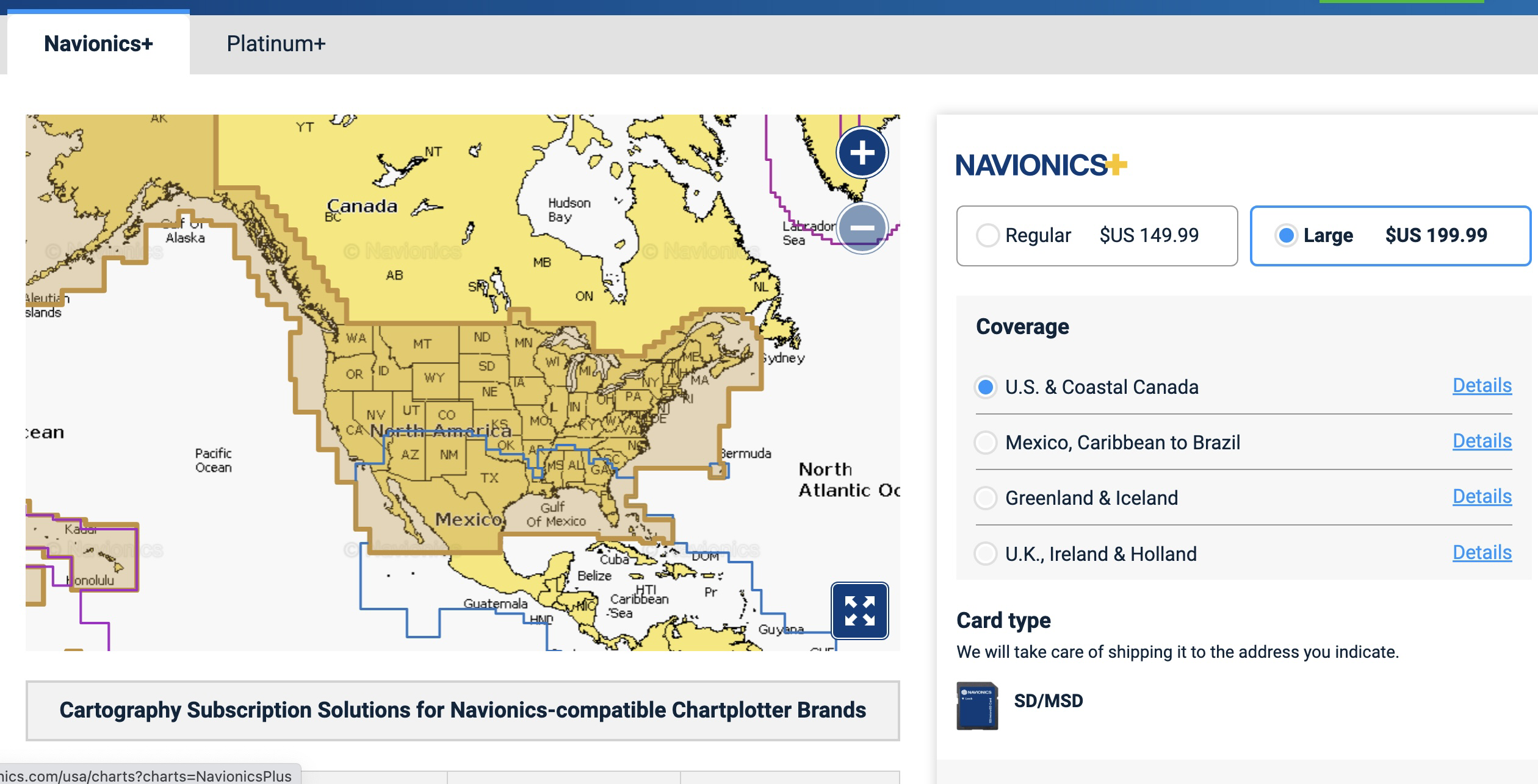
The agreement to integrate Navionics data in TimeZero products has recently expired and has not been renewed; Furuno TimeZero will no longer integrate Navionics cartography content. However, Navionics+ and Platinum+ cartography products continue to offer compatibility with several third-party chartplotter brands such as Furuno, Raymarine and Simrad – to name a few. As I mentioned below (see highlighted), a recent software update for Furuno plotters offers compatibility with Navionics cartography.
Garmin media relations
It turns out the crux of the issue is the reformatting of the data into MM3d format. Navionics and MapMedia had an agreement in place that allowed MapMedia to reformat the data. That agreement recently expired, and Garmin, Navionics’ corporate parent, chose not to renew the agreement.
While I understand that Garmin is looking to control how Navionics data is distributed, there’s also some irony to this decision. At the same time that Garmin has launched Navionics charts for Garmin MFDs –with a proprietary format– they’ve decided not to renew another proprietary format.
OEM discounting
As boat shows have started back up, I’ve been able to have more in-person conversations. Those conversations often lead to some off-the-record indications of how things are going. One steady theme I’ve heard from multiple companies is that the availability and cost of charts are getting worse.
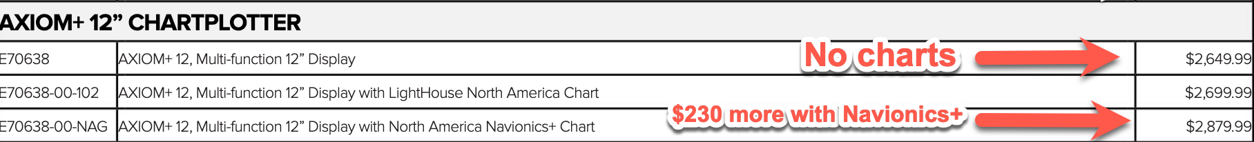
From what I’ve heard, both C-Map and Navionics have eliminated OEM discounts. These discounts allowed MFD manufacturers to offer premium cartography at a discount compared to the cost of buying a chart plotter and the cartography separately. But, if you look at Raymarine’s 2022 price book you’ll see that it’s actually more expensive (at list price) to buy your charts bundled with your MFD than separately.
The $230 premium is quite a change from the $50 uptick Raymarine charged for Navionics+ when Axiom MFDs were introduced in 2017. But, there’s still a $50 charting option courtesy of Raymarine’s much improved LightHouse Charts. Raymarine has invested in developing their LightHouse Charts. They have made a significant investment into LightHouse Charts and offers premium point-of-interest data from MapBox, Reeds Almanac, Marinas.com, and more.
Raymarine isn’t alone in developing its own charts and chart store. As I mentioned above, Furuno and TimeZero run their own chart store with MapMedia. They make several third-party charts available as well as those from government hydrographic survey offices like NOAA. But, the need for control over chart data isn’t limited to the brands we’ve discussed so far. Si-Tex will be launching their own Polaris Charts soon as well.
All navigation charts I know of start with government hydrographic offices. The difference between the various products is typically the private data layered on top. So, it’s not easy to assess the differences between the charting options.
C-Map X-series charts
When Simrad launched their new NSX chart plotter based on Navico’s next-generation Neon operating system, they also unveiled C-Map’s new X-Series charts. In my testing with NSX, I’ve been impressed with the visual appeal, speed, and functionality of the charts.
Currently, NSX and its Neon operating system are the only option for X-Series charts. I was nervous that perhaps Simrad parent Navico would decide to only make these charts available to Navico companies. Fortunately, that’s not the case.
C-MAP has a long history of working with the widest range of MFD makers, and there has been no change of policy here. As the X-Series is a new technology type it will require software updates from these manufacturers in order to run, therefore it is not immediately available, but is certainly a possibility for the future.
Navico media relations
The good news is that the charts will be available to others. The bad news is that NSX launched without support for Navionics charts, a departure from the current crop of Navico branded (B&G, Lowrance, and Simrad) products. I’ve asked if this might be added in the future, and it doesn’t sound likely.
Final thoughts
I don’t think the sky has fallen. Charts will be available regardless of what platform you use. But, will you be able to use your chart provider of choice? That answer is less clear, unless you’re on TimeZero and your chart of choice is Navionics. My crystal ball is pretty foggy about how things will evolve, but for now it looks like your choice of MFD will also determine your choice of charts.


You do not mention using NOAA source charts — ENCs — rather than commercially repackaged/re-engineered chart products. I have used pc-based OpenCPN and ENCs downloaded from NOAA for the better part of 10 years and enjoy the flexibility that MFDs do not provide.
Sometimes now the choice of marine chart is determining the choice of MFD. Apparently Garmin and MapMedia couldn’t reach an agreement on data security which is why Furuno devices that accept cards get Navionics but TZT don’t.
Ray,
If I recall correctly the TZ charts from Mapmedia are all securely encrypted. A physical device, such as an SD card doesn’t enable data security by itself. The Furuno TZ plotters all utilize a physical device such as an SD card to load cartographic data from. I think its a simple shameless commerce decision to enhance the standing of Garmin MFDs vs Furuno TZ MFDs. I don’t like it as an owner of TimeZero and Furuno TZ MFDs. None the less its normal commercial behavior.
Unrelated to the actual post, but I noticed that pic of a C-Map Reveal X chart is putting the marks on elevated “hatch marks” with the result that the mark symbols don’t appear to be where they actually are. Confusing and poor interface design imho. Hope there is an option to disable that feature and put there marks where they actually belong.
This is why programs like OpenCPN are so great. Not being tied to one source of charts from a single company’s charts makes sense on many levels; most importantly, it is the safest way to navigate. Every charting source has errors. Comparing multiple sources (as one can do in OpenCPN) is an important practice. There are now many free sources of MBTiles charts for download (like TheChartLocker.com). You can also download all NOAA charts directly from within the program (for free, of course).
I have a Garmin Plotter on one vessel I will soon be letting go of (the vessel), and have been contemplating what to use on my catamaran. Presently, I use my iPad and see no reason to change that as this device seems to be in a category of it’s own. It’s light on power, and updates regardless of the system I want to chart with based on the manufactures app updates/improvements. I’d sure like to see a thorough exploration of tablet navigation at this stage, in an article with your expert insights. Why buy a plotter that will be out of date in a couple years, when you can use a tablet (often much cheaper) that will be able to keep up with the back end changes the plotters can’t?
iPADs certainly work well if you have a nearby power source AND don’t use them in direct sunlight. I am in the middle of an MFD replacement and will end up with an Axiom 12+ at the helm and eliminate my Nav station MFD. Down there I can use my iPAD.
Yes, the functionality of an iPhone/iPad beats a chart plotter all day long, but try using an iPhone at an exposed helm in weather and you’ll wish you had a old school MFD.
You are absolutely right, Robert. The move to everything having a touch screen is a huge problem. Wet hands, cold temps, moving boat, dark night, flying spray… give me a keyboard and a mouse, or buttons on a panel. They are the only thing that work.
I had been using Navionics charts on my iNavX.
But recently, Navionics stopped providing their cherts to iNavX. I don’t Know why.
Can’t stress enough how important it is to have multiple sources of charts. Here in the Tuamotus, multiple satellite image sources (ArcGIS, Google, Bing) make navigation much easier and safer in the atolls when combined with marine charts. If you buy an iPad or chart plotter you will not have options. If you have an android tablet, raspberry pi, PC, or Mac, you can install OpenCPN and can install charts from multiple sources.
Agree that you should have multiple sources. Completely disagree that an MFD and/or iPAD prevent this. on my iPAD if I wish, I can have access to no less than four different chart sources plus Bing/Google Mpas/Google Earth etc. Did you know you can download and save google maps.
What app are you using on your ipad?
Navionics. Works very well and not very expensive.
Our problem is Japanese chart is protected under copyright.
In the past, I heard none of the distributions, such as C-Map, Navionics and so on.., had licensed the charts.
I don’t know about current versions.
Hi Atsushi. Most countries copyright their chart data — the U.S. a big exception — but they usually license it to commercial chart makers. In fact, both Navionics and C-Map seem to have full electronic chart sets of Japan for chartplotters at reasonable prices:
https://www.navionics.com/usa/shop/charts/navionics/regular/navionics-plus-japan-1.html
https://www.c-map.com/search-charts (just select “Japan” in first search box)
Also, charts for Japan for the Navionics Boating app cost $30, and I think that C-Maps for app use are similarly priced.
Ohayo gozaimasu, Astsushi-san,
When we were sailing in Japan in 2016 and 2017, we used a combination of Navionics on an android tablet (the charts are much cheaper than those purchased for plotter/PC platforms), and OpenCPN using CM93 charts (the older ‘free’ version). We supplemented CM93 with some KAP charts made from satellite images (I’m happy to share what I have). I was recently considering making a set of OpenCPN marine/satellite charts for Japan but have been advised that almost everyone is using NewPec these days. Still, I may make a marine chart version for OpenCPN before we return… but that won’t be for several years. Mata ato de.
Lets talk about a different problem. Just how out of date are those charts you get for your MFD. Astonishingly, they may be a year old. That warning that pops up about not using your chartplotter for actual navigation seems to be a real thing.
This is actually an important question.
Just how important was highlighted in an article in the Nov/Dec issue of the BoatUS magazine.
https://www.boatus.com/expert-advice/expert-advice-archive/2022/november/when-and-how-electronic-charts-are-updated
Those charts for your expensive marine chartplotter – may be either reasonably close to current (only a month or two or three behind the NOAA updates) or dangerously stale (perhaps close to a year out of date.)
The advantage of Rosepoint Coastal Explorer which I have and like or OpenCPN which I have also played with – you can use the actual NOAA ENC charts. which get updated regularly and are free.
The article mentions some examples, based on the author or friend checking to see how long it took for NOAA chart updates to show up in the chartplotter maps.
Raymarine – charts are only updated infrequently, perhaps only once a year. Garmin – within a couple months after NOAA publishes updated ENC chart data. Aquamaps – within about a month. While the examples listed in the article are one-off anecdotal, the Raymarine marketing manager is quoted “LightHouse Charts are updated on an annual basis, or more frequently,” said Raymarine marketing manager Jim McGowan.
C-Map would not answer questions. That does not inspire confidence.
I am rethinking my reliance on my Raymarine chartlotters for navigation info. I am now thinking the better choice is Rosepoint Coastal Explorer or OpenCPN for charts that are current and include all recent USCG and NOAA updates, plus Aquamaps for the intelligently presented Army Corps of Engineers data, and Navionics app for the crowdsourced sonar chart data.
Note – I am assuming that Rosepoint NOAA charts are actually very current. I’ve asked that question, and am waiting on an answer.
Heard back from Rosepoint – updated NOAA ENC charts show up in the Rosepoint chart store/auto update process within a couple of hours after publication by NOAA.
Heard back from Rosepoint – updated NOAA ENC charts show up in the Rosepoint chart store/auto update process within a couple of hours after publication by NOAA.