
Garmin MFDs get Navionics cartography and an updated UI
For the last several years there’s been an unusual situation with Garmin MFDs. They haven’t used Navionics chart presentation or auto-routing. Considering Garmin owns Navionics and has since 2017, that’s left many scratching their heads. Well, scratch no more. Current Garmin MFDs can now use Navionics’ charts, auto-routing, and daily updates. Plus, the ability to display the new Navionics charts is part of an upgrade to Garmin MFDs that includes an updated user interface.
In 2019 Garmin released BlueChart g3 charts built using Navionics data. Although g3 used Navionics data, the presentation stayed the same and the charts looked basically the same as BlueChart g2. Chart updates continued to be released twice a year. Lastly, auto guidance on GPSMap MFDs pretty clearly used a different algorithm than Navionics’ Dock-to-Dock Autorouting. Honestly, it all felt a little strange.
Garmin bought Navionics in 2017 and in 2019 they released new charts that didn’t use some of the best features of their acquisition. But that’s all changed now. Garmin Navionics+ seems to be an elegant merger of the GPSMap’s software with Navionics’ cartography.
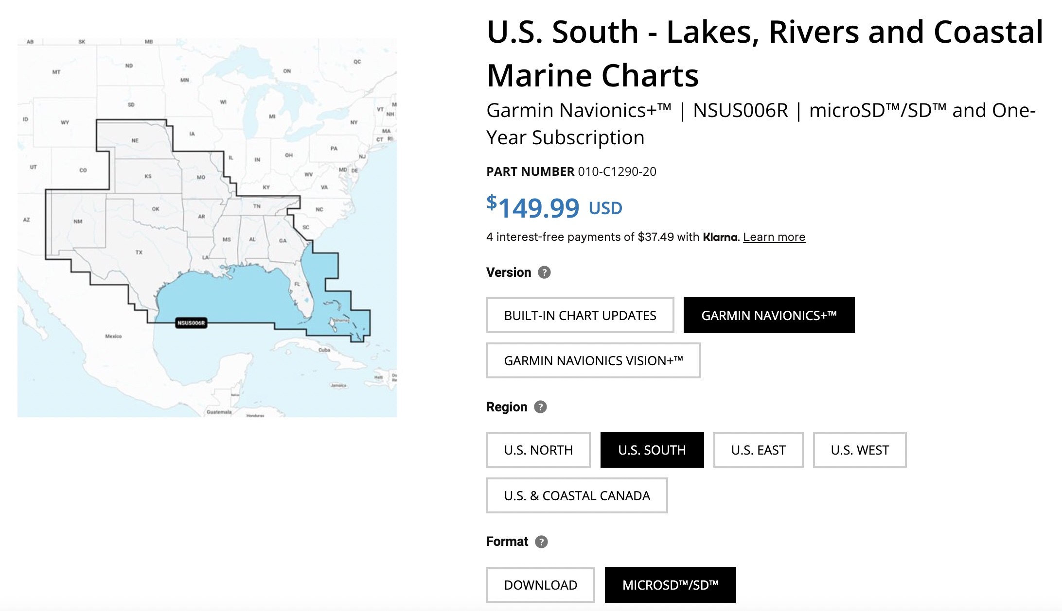
Garmin MFDs need their own version of Navionics cartography. So, if you have a Navionics card from another MFD, it won’t work in your Garmin unit. In the United States, each of four large geographic regions cost $150, or the entire U.S. and Coastal Canada can be purchased for $200. Vision+ charts are only available by region for $250 each. Garmin says the additional $100 gets you “high-resolution relief shading, sonar imagery, unique 3D views, high-resolution satellite imagery, aerial photography, and more.” The U.S. South and the U.S. and Coastal Canada appear to include coverage for the Bahamas. Currently, charts are only available on a physical MicroSD card, though the website says download options are coming soon.
Chart appearance
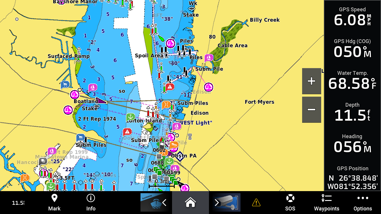
Navionics Boating HD 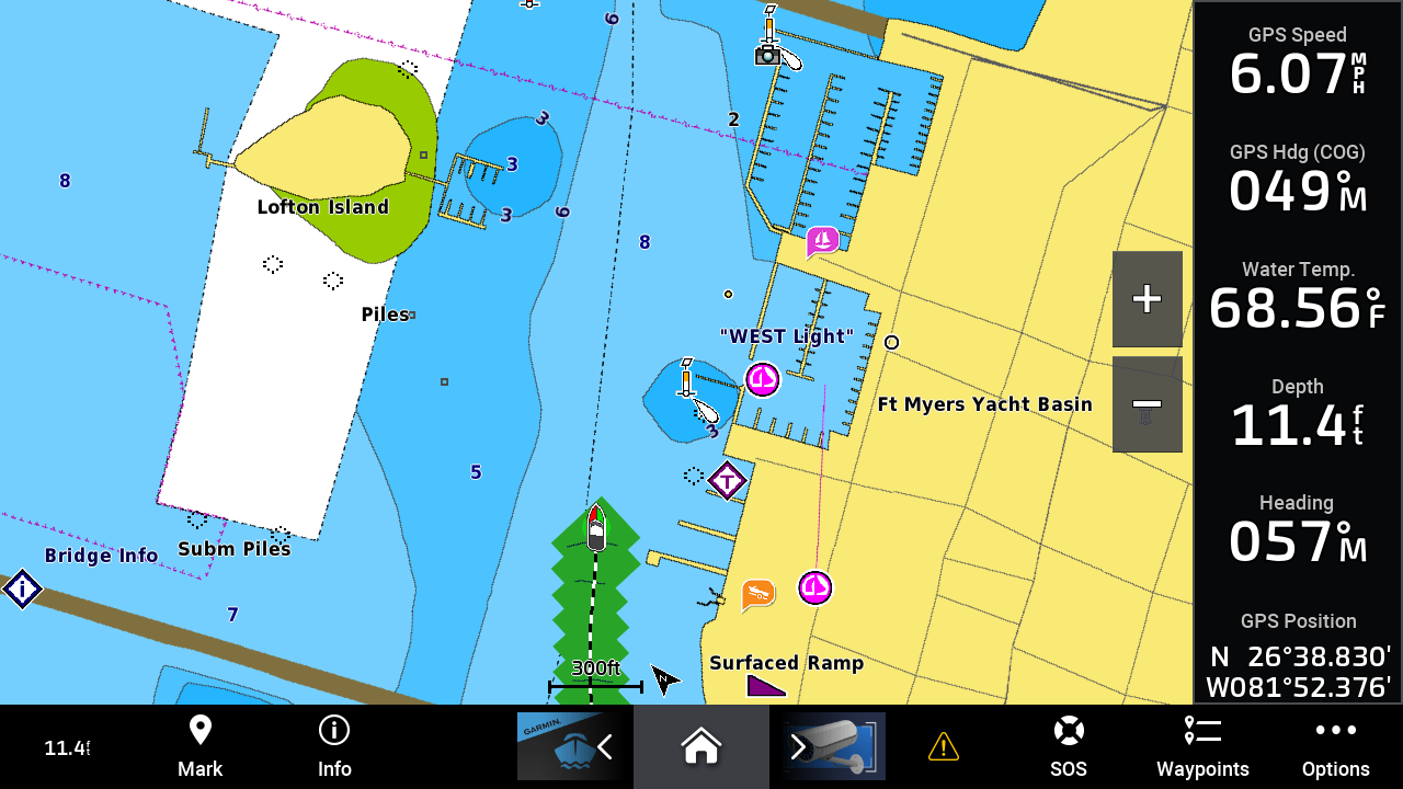
Garmin Navionics+ on a Garmin MFD

It’s a matter of personal taste but I find the display of Navionics+ cartography on Garmin MFDs visually pleasing. I like the color scheme employed better than the one used by BlueCharts or the traditional Navionics coloring. The colors are a little more vibrant. Using BlueCharts I sometimes feel that Garmin oversimplifies the chart in order to cut down on visual clutter and confusion. It looks like they continue to simplify the chart, but, so far the details I’m seeing omitted seem pretty minor, like the red-hashed otter trawl closure area shown on the Navionics screenshot on the left.
I haven’t found Navionics’ Sonar Charts, I don’t think they’re available on a Garmin MFD yet. I hope that changes, or maybe I’ve just missed it.
Auto guidance compared
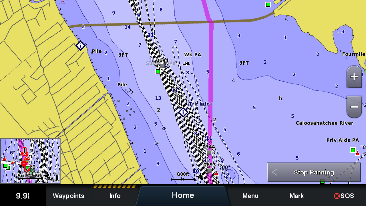
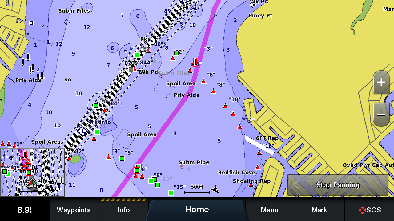
I routinely warn boaters to review any automatically created route very carefully before following it. On the waters of the Caloosahatchee River, my adopted home waters, I’ve found Garmin’s (now previous generation) auto guidance to be highly suspect. The routing routinely leaves the safe confines of a navigable channel for reasons I can’t determine. The screenshot above shows the magenta line of the automatically calculated route leaving a 9 to 13-foot deep channel to take a path that includes two-foot waters.
Let’s compare auto guidance with BlueCharts g3 shown above. Then, take a look at the route built by Garmin Navionics+ Autorouting.
I’ve done quite a bit of route planning using the new charts and have been consistently pleased with the results. But, that still doesn’t mean anyone should blindly follow the routes it creates. There’s still room to get yourself in trouble following the routes it creates. Especially when there are unusual marker swaps, private marks, or other complications.
We don’t know exactly how auto guidance routes are built but the Garmin press release announcing the new charts gives some hints:
After selecting departure and arrival points, Auto Guidance+ considers a variety of factors – overhead clearance, chart data, popular routes and desired depth – then creates a suggested route for mariners to follow to their destination.
In discussing the new charts, Ben Ellison recalled a conversation he had with Navionics founder Giuseppe Carnevali some years ago. During that conversation, Carnevali mentioned that they could use frequently traveled routes to weight the best route through an area. It looks like that’s exactly what they’re now doing.
Warnings, warnings, warnings!
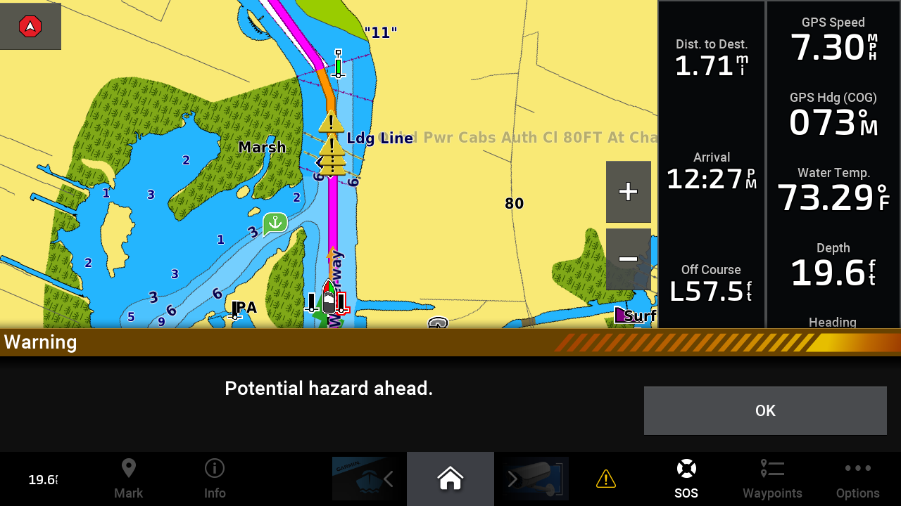
The warnings cover the bottom third of the screen 
Warning manager shows a screen full of warnings from about half an hour of low-speed cruising 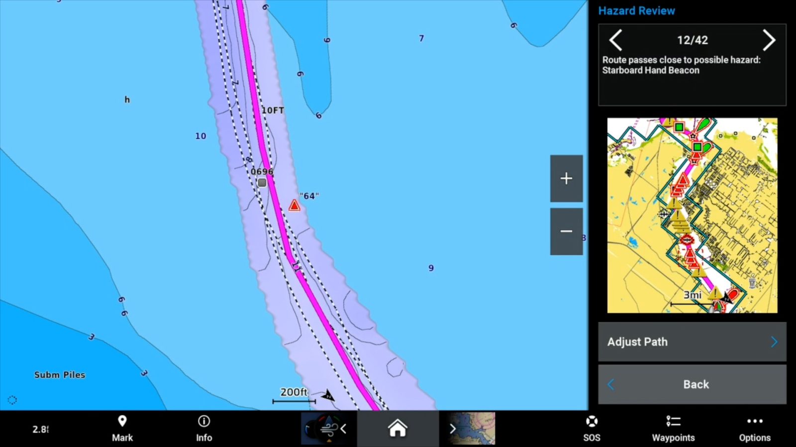
This hazard is because the channel passes close to a marker
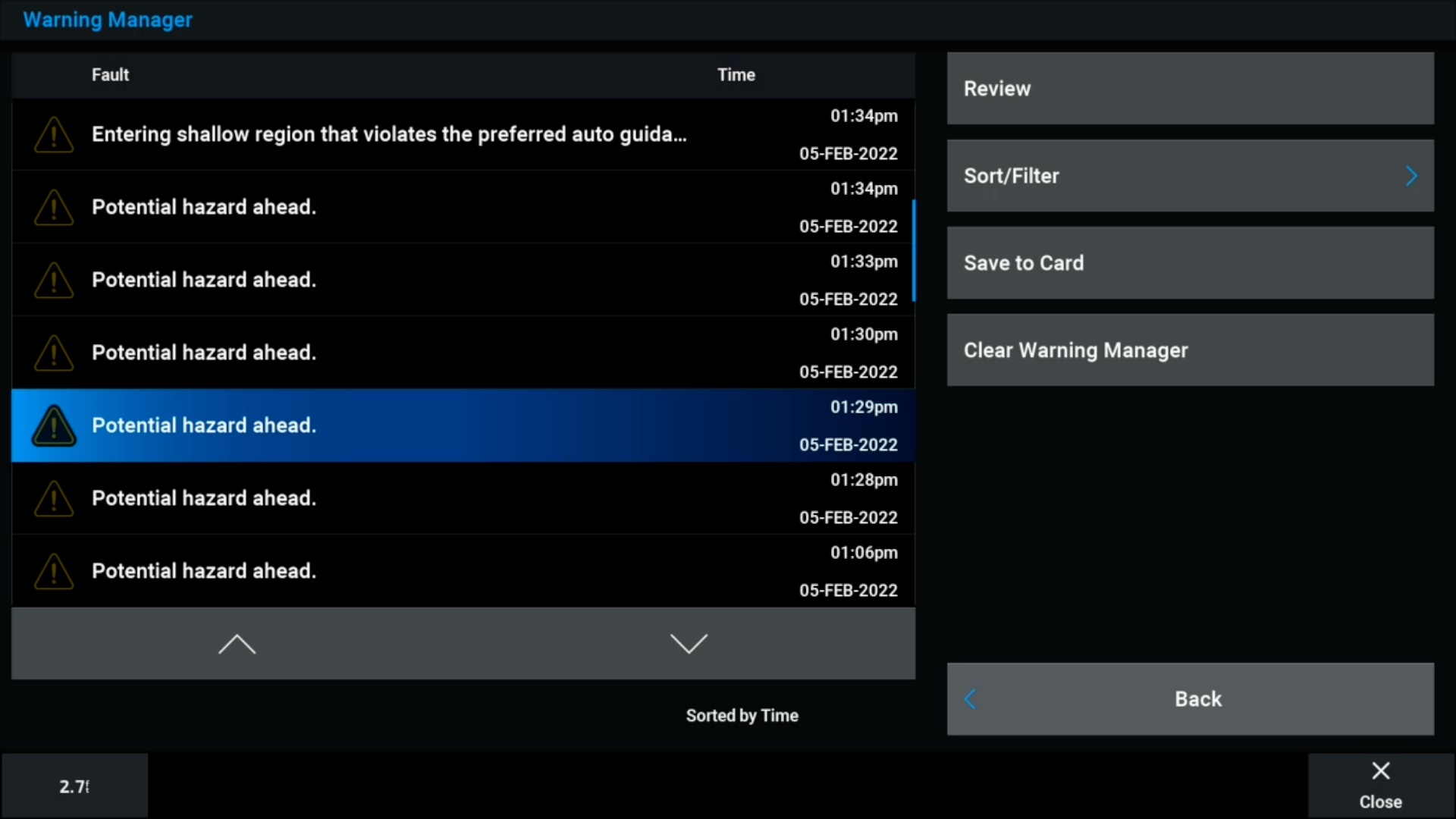

First, I need to admit this rant might be a little misplaced. I’ve tried very hard to figure out how to turn off the warnings you see above, but I haven’t had any success. When using an auto guidance route, the MFD will warn you of any hazards on your route. These hazards can include anything from bridges, wrecks, other hazards, or even passing close to a marker.
I think firing a warning because the route will pass by a marker is pretty silly. It’s a lot more sillier since the warning can’t be turned off (maybe it’s just that I can’t find it?). I’m a big believer in not firing unnecessary warnings. The only thing they do is condition the operator to ignore them. In this case, that’s exactly what I do with all the hazard warnings.
UI updates
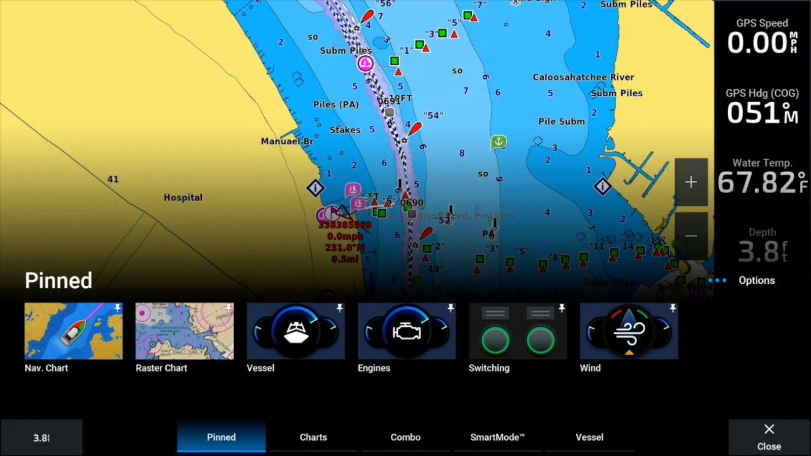
Instead of a separate home screen it’s now an overlay over the bottom of the screen 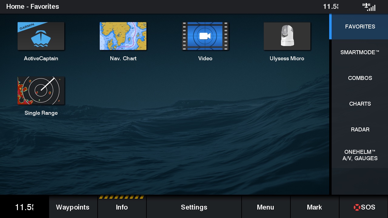
The previous versions’ homescreen
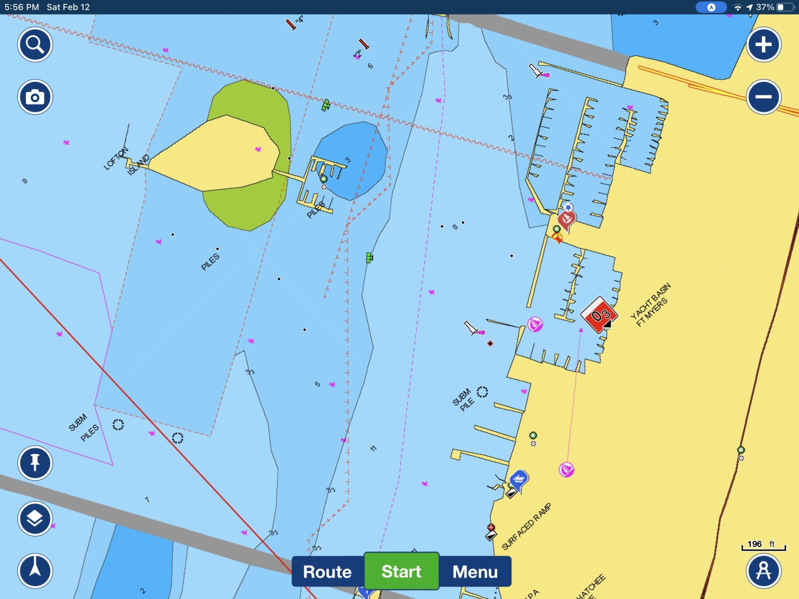
Garmin GPSMap software release 26.10 brings Navionics+ compatibility and a refreshed user interface. Overall, I think the new UI looks really good. It’s a pretty mild freshening overall. The single largest change is replacing the home screens with a home overlay. Instead of full home screens with multiple rows of icons, pressing the home button now overlays a single, scrollable row of icons overlayed over the current function.
I haven’t fully adjusted to the new home functionality. In some ways, I miss the dedicated home screen but also appreciate the ease of switching between functions without losing visibility of the current function.

My biggest complaint is that Garmin has buried the MFD settings in a spot I don’t find intuitive. When you press the home button there are three dots and the word Options is displayed on the right side right above the icons. Pressing that brings up the screen you see above with a settings button on the bottom left. I use the settings on an MFD quite a bit and think Garmin buried it. I’m hopeful that a future release will make the settings more prominent.
Final notes
Garmin was due for this update and I think it’s a good one. They’ve done a nice job bringing Navionics’ data and presentation to their MFD software that was (I suspect) never intended to consume Navionics data. And, I should mention that my conversations with numerous MFD product managers and developers suggest this is a larger effort than many may realize.


Sat images a d relief shading are there. You have to load them through active captain. This whole update is cumbersome. It is worth the effort to get ride of Bluechart though.
Thanks, Evan! I would have thought that the hi-res satellite maps and relief shading came on the Garmin Navionics Vision+ card, but the Navionics site — which has more detail than Garmin — confirms the need to download them via ActiveCaptain:
https://www.navionics.com/usa/charts-garmin-navionics?format=Large&charts=GarminNavionicsPlus
And let’s all note that you have to have an active Navionics subscription to download and or update any chart types, though you won’t lose what’s already downloaded if you let the subscription run out. Good reason to setup a large AC SD card.
Ben, Garmin claims “up to 1′ contours” for Navionics+, so I wonder how you turn that on and whether it’s the equivalent of Sonar Charts… and if so, is that stated somehow?
And readers please note that there are already some valuable Panbot comments to the Navionics+ press release:
https://panbo.com/plot-your-paradise-with-new-garmin-navionics-marine-cartography/
Oh, and if true, the thing about Navionics using real boat tracks to improve auto-routing is possible because they’ve collected a great many tracks that came in with sonar chart submissions.
But I’d also like to think that the Navionics auto-routing algorithm actually takes navigation aids into account, and I see some hints that the new C-Map auto-routing on the Simrad NSX does similar, and am glad that you’ll be able to check that out soon.
Any information regarding when this new software will include Central/South America and the Caribbean?
Ben, I am unclear about something, if you can update Garmin legacy equipment like the 5212 (I have no idea if you can) to run Navionics charts, can you still run the old Garmin charts the same MFD? For example, we use charts for Florida and the Bahamas as well as inland lakes and rivers for the US. If we update the MFD can we use both the old Garmin charts as well as the new Navionics charts, or must we change all our charts to Navionics? If we must change all our chart to the new Navionics, that is not only expensive, but we would lost the Explorer charts that Garmin used before they dropped the Explorer charts in there updates several years ago. Yes, that right, we do not update the chart chip for Florida and the Bahamas because Garmin dropped the most accurate charts for the Bahamas, Explorer Charts. We run a laptop with Coastal Explorer at the same time
The new Navionics charts will load only on MFD’s that are presently sold by Garmin. I have a 7612 and a 942 – both installed in the last 5 years – and neither can use these charts.
So does that mean that we have expensive paper weights, and that no future chart updates of any kind can be purchased?
I don’t think so. It appears Garmin is continuing to produce updates for the Bluechart G3 maps. But for how long is anyones guess.
I asked Garmin exactly this question when I met with them at the Miami show. They’re working on getting me an official statement but the gist of the conversation was that they will continue to update G3 cartography for a long time. They’re aware that some models of MFD that can’t load the Navionics cartography were sold in 2021 and they plan to make sure all owners of G3 compatible MFDs have updates.
-Ben S.
I checked with Garmin Sweden and got the following answer:
An updated MFD will be able to present both GN+ and BlueChart. The BlueChart will have the same look as previous, only GN+ chart will have the Navionics look.
If you insert both GN+ and Bluecharts into two slots, both charts will be presented. GN+ will be prioritized if they cover the same area. The transition between GN+ and BlueChart on the screen will be seamless.
I have an additional information that I just received from Garmin Sweden. When using both Garmin Navionics+ charts and Blue Charts in the same MFD they work seamless with GN+ prioritized. The only drawback is that Autoguidance (previous named Autoroute) stops when it comes to the point where the transition is between the charts. Then you have to start a new Autoguidance in the other chart.
Regards, Patrick
Any idea if the MicroSD card is usable on other platforms like Navionics are? One reason I bought Raymarine in the past was the ability to use the Navionics card on a PC with Fugawi. I found it easier to create routes on the PC and upload them. And the redundancy in case the plotter or PC died was useful.
I’ve been in the Garmin ecosystem for 13 years and used to do the same – create routes on my PC with Coastal Explorer and the transfer them via SD card to my Garmin MFD. Then Garmin released ActiveCaptain for the iPad. Goodbye PC and CE. I now use AC on the iPad to build routes and then transfer them via Wi-Fi to the MFD’s. So much easier. And the iPad can serve as a backup in case I lose all my Garmin screens.
You’re the first Coastal Explorer user, that I know of, that finds building routes on any platform easier than on CE. For me there isn’t one even coming close to Coastal Explorer.
It’s not. The Garmin Navionics chart cards are a different formation than Navionics cards for other platforms.
-Ben S.
Will this be the reason for Furuno to discontinue Navionics? Likewise Timezero.
http://www.furunousaforum.com/viewtopic.php?f=2&t=9903
What’s interesting not only in the Navionics world of Garmin but the C-Map World of the Navico product lines. Looking at the specs of the new Simrad NSX series MFD you see they have created an entirely new chart series C-Map X. There are two versions of the new cartography Discover X and Reveal X with Discover X = to Garmin Navionics + charts and Reveal X = to Garmin Navionics Vision + charts. In regards to Furuno, I’m not sure their reasoning for dropping Navionics charts? I just upgraded my Navionics Plat + charts for my my Raymarine Axiom 7 RV and they work just fine with no additional software updates needed from Raymarine. Remember to, Reveal can only be displayed on Navico products.
We have two of the largest brands that own chart systems Garmin & Navionics and Brunswick who owns Navico and C-Map. Where this all goes is still a mystery.
Cheers ….
Tom
Right, for starters C-Map Discover X and Reveal X charts will only work with the new Android-based NSX displays, but it seems likely that they will be supported by future Navico displays and maybe by other brands. I too don’t know why MapMedia is dropping Navionics vector data, and I think that both C-Map and Navionics remain willing to work with other display manufacturers.
It sounds like both remain willing to work with other vendors but, I’ve also been told that both eliminated the bundled card option for their products. Apparently, that was a very inexpensive way for MFD manufacturers to purchase charts. Now, they’re buying the retail cards at wholesale, just like a retailer. That means the cost of bundling charts goes up for the manufacturers. It seems logical the result will be Navionics charts will mostly only be bundled by Garmin and C-Map only by Navico brands. It’s also got a lot to do with why companies like Raymarine are investing in their own charts.
-Ben S.
While meeting with Garmin at the Miami show I learned that SonarCharts are available via the Active Captain app if you have the Vision+ charts. That’s a difference from Navionics charts on other platforms where, I believe, Sonar Charts are available with all charting options.
-Ben S.
You can also get to system settings from any page by pressing 3 dot Options in the lower right and then Settings in the lower left
I’m really confused about where these new Navionics charts fit into Garmin’s cartography lineup.
I have an 8600 series MFD and I bought the Bluechart g3 Vision+ chart for my area last summer. It seems I’d be getting more coverage and the same features with the Navionics Vision+ charts, plus regular updates. But I have an investment in Bluechart at this point. What are the arguments for sticking with with Bluechart? And for switching to Navionics? And will there be a path from Bluechart to Navionics for Vision chart owners?
At some point, G3 will go bye-bye where updates are concerned. At that point you will have to decide to either go without updates or upgrade. As of yet, I’ve not heard of any incentives for early adopters.
Sonar charts are shown by selecting “fishing chart”. I now use fishing chart all the time as I frequent a shallow bay and the sonar chart contours are much more precise than the nav chart contours.