
Plot your paradise with new Garmin Navionics+ marine cartography
New marine cartography from Garmin delivers all-in-one inland and coastal mapping, access to daily chart updates, new Auto Guidance+ technology and more to Garmin chartplotters
OLATHE, Kan./Jan. 19, 2022/Business Wire – Garmin International, Inc., a unit of Garmin Ltd. (NYSE: GRMN), the world’s largest1 and most innovative marine electronics manufacturer, today announced Garmin Navionics+ and premium Garmin Navionics Vision+ for Garmin chartplotters, the newest generation of marine cartography products from Garmin. Wherever mariners choose to plot their paradise, new Garmin cartography products offer an all-in-one mapping solution that integrates detail-rich inland and offshore content, as well as a variety of tools to support smarter and safer navigation.
“Garmin Navionics+ and Garmin Navionics Vision+ offer our best and most feature-rich marine cartography experience to date – a true game-changer for boaters and anglers,” said Dan Bartel, Garmin vice president of global consumer sales. “Now, with new coverage regions, mariners have the freedom to confidently explore inshore and offshore waters with a full suite of mapping content and advanced features. Plus, with access to daily chart updates, mariners can stay informed about the latest changes to their maps and charts and benefit immediately from new cartography releases.”
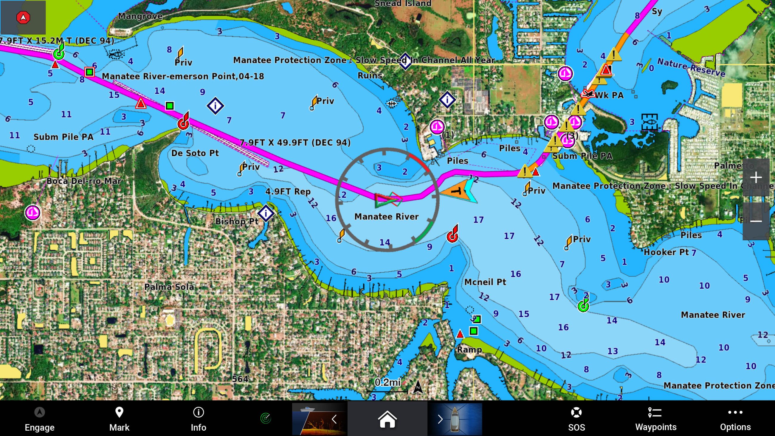
In addition to unparalleled worldwide coverage and No.1 marine mapping1, new Garmin cartography offers a myriad of features – including an all-new chart presentation, daily chart updates and advanced autorouting capabilities – that are designed to smoothly guide boaters on the water, or quickly lead anglers to where the fish may be hiding. It also features color-shaded target depth ranges, up to 1-foot depth contours, free downloadable NOAA raster images2, shallow water shading and exclusive access to ActiveCaptain community content for valuable insight on points of interest (POI), recommendations and advice from fellow boaters.
Here’s what’s new with Garmin cartography:
New, redesigned chart presentation
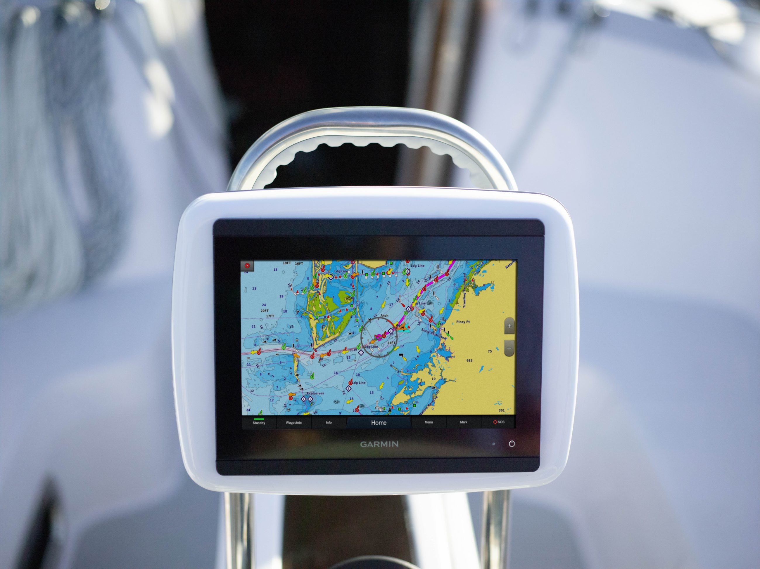
Garmin Navionics+ and Garmin Navionics Vision+ introduce an improved look and feel – with vivid color palettes and greater detail of coastal and inland features – to deliver a new, on-screen cartography presentation for more intuitive navigation on lake or sea. This new interface displays charts in striking detail with a crystal-clear look at the depths below the boat, as well surrounding structure and navigational aids above the waterline.
Up to 5,000 daily updates
With up to 5,000 updates to chart content every day, Garmin’s new cartography products offer the latest insights about any body of water for enhanced situational awareness and peace of mind while navigating. Daily chart updates combine millions of contributions from private and public surveyors, crowd-sourced data and more, delivering the freshest, most up-to-date content each time mariners leave shore. With coverage of more than 42,000 lakes worldwide, daily updates allow for immediate access to new chart data and lake content as it is released. A one-year subscription is included with the purchase of Garmin Navionics+ or Garmin Navionics Vision+ and offer a quick-and-easy way to sync a mobile device to Garmin chartplotters for unlimited daily updates via the ActiveCaptain smart device app.
Advanced autorouting technology
New Garmin cartography also includes Auto Guidance+ technology3 with faster route calculations and improved routing detail. After selecting departure and arrival points, Auto Guidance+ considers a variety of factors – overhead clearance, chart data, popular routes and desired depth – then creates a suggested route for mariners to follow to their destination.
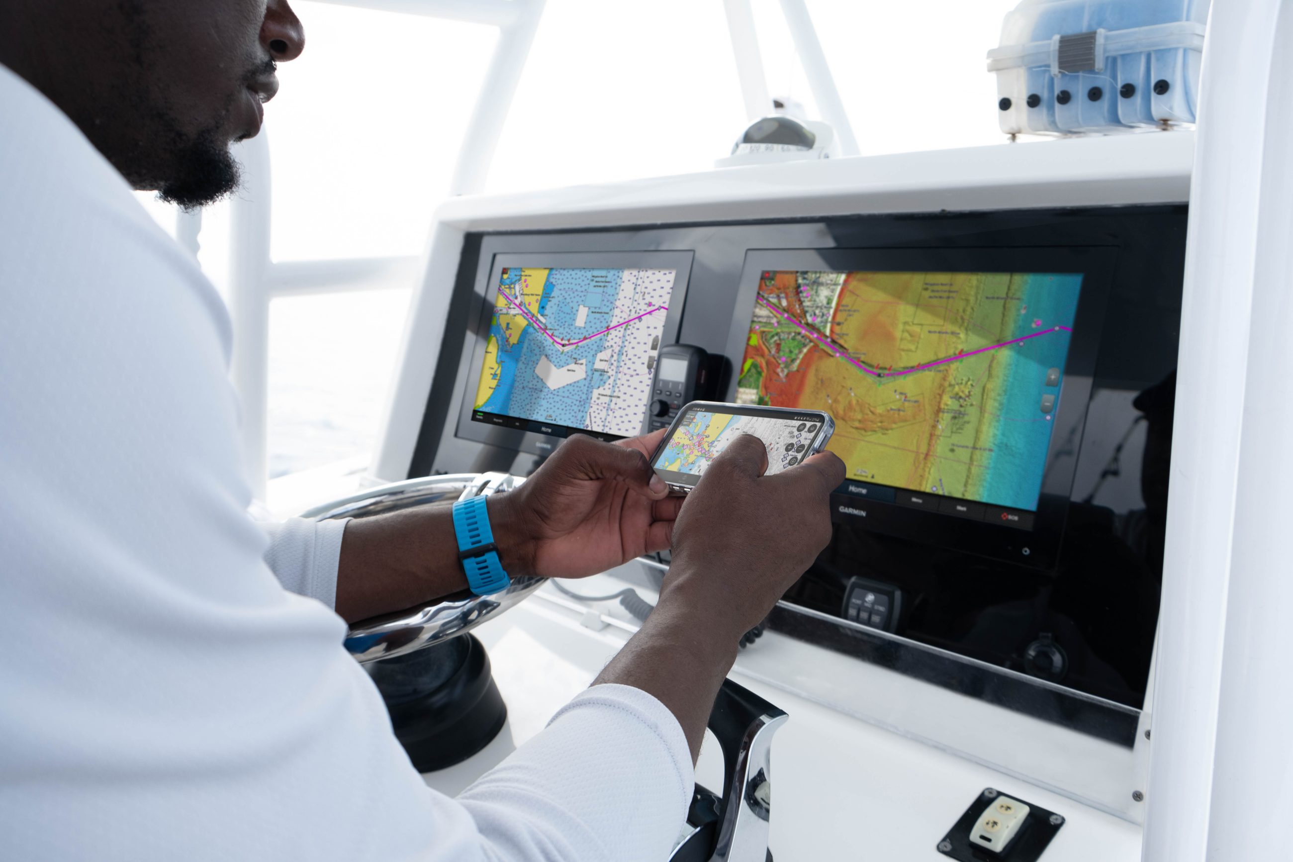
See more with premium Garmin Navionics Vision+ content
For more advanced features, boaters and anglers can upgrade to premium Garmin Navionics Vision+ to discover more about the coasts they cruise or lakes they fish. Premium Garmin cartography includes all the standard features found in Garmin Navionics+, with the addition of high-resolution relief shading, sonar imagery, unique 3D views, high-resolution satellite imagery, aerial photography and more.
Garmin Navionics+ and premium Garmin Navionics Vision+ can be purchased via download or microSD card for compatible Garmin chartplotters with suggested retail prices ranging from $129.99 to $399.99, based on varying coverage. Compatible chartplotters with built in g3 cartography can convert to Garmin Navionics+ content with the purchase of an update microSD card; Simply install the update card to receive the enhanced content and gain access to daily updates.
Garmin Navionics+ and Garmin Navionics Vision+ are compatible with current Garmin chartplotters, including the GPSMAP 8400/8600, GPSMAP 7×3/9×3/12×3, ECHOMAP Ultra, ECHOMAP UHD series and more. Previous chartplotter models, such as the GPSMAP 7×2 Series, will continue to have access to updates of Garmin BlueChart g3 coastal charts and LakeVü g3 inland maps with Navionics data via download or microSD card purchase. For more information about Garmin cartography and chartplotter compatibility, click here.
1 Based on 2020 reported sales.
2 Raster cartography cannot be viewed on echoMAP™ CHIRP and ECHOMAP™ Plus combos but can be viewed on mobile devices via the ActiveCaptain mobile app
3 Auto Guidance+, Auto Guidance and Dock-to-Dock Autorouting are for planning purposes only and do not replace safe navigation operations
Related Posts:


Panbo publishes select press releases as a service to readers and the marine electronics industry. The release contents do not reflect the opinion of the editors and are not fact checked by the editors


This is a pretty big deal as Garmin seems to have dropped most their own chart presentation style in favor of how Navionics does things. That may take some getting used to for some users, but I suspect that anyone unfamiliar with Navionics Dock-to-Dock autorouting will like what Garmin now calls AutoGuidance+.
Also nice to see that the ActiveCaptain app will now support the Navionics rapid updating system, but that Garmin did not drop the free U.S. raster chart feature.
There’s also a Navionics 2022 press release out today with the main news being a “streamlined catalog of Navionics+ and premium Platinum+ charts” that include lake and river mapping. In other words, I think, formerly separate Navionics Hotmaps Platinum coverage is now included with Platinum+ coastal charts.
https://www.garmin.com/en-US/newsroom/press-release/marine/navionics-introduces-new-2022-marine-cartography/
The other interesting thing is Garmin has combined chart regions in the new Garmin Navioincs Vision + series that used to be separate from one another (.i.e) the Carolina’s, the mid Atlantic plus the Northeast region were separate now they have been combined at a new lower price 259.00 for all three.
Hmm, what does this do to those of us using Navionics on our brand new Raymarine Axiom+ chart plotters – and on our stand alone Android tablets?
Stephen, I don’t think you’ll experience any negative changes. In fact, now that Garmin has apparently chosen Navionics as its native chart format going forward, there may be more budget for improvements, data collection, etc.
On the other hand, I don’t know how long Garmin will continue to update BlueChart G3 data as their displays that can not use Navionics+ get older and older. And it’s a bit odd that the G3 format is only three years old.
This means my plan to get something new next to the 7612 now sounds more like get two new things side by side for maps to match. But that also means all brands are open for the replacement…
It sounds like Garmin is going to offer features on Navionics that can only be accessed if you buy a Garmin plotter. The rest of us will get ‘simpler’ versions offering fewer features. If they follow the same path with Active Captain and Vesper, it will be truly unfortunate.
How does it sound like that, Joel? I don’t see any feature in Navionics+ or the new Vision+ that isn’t in regular Navionics or Platinum+ charts. I guess you could point out the NOAA raster chart support that Garmin still offers, but it’s quite separate from both Bluecharts and Navionics.
It’s hard to tell in my Active Captain app (how I update anything on my GPS 1222) if updating the charts will give me this new interface. Any insights?
Hi Randy, Garmin’s Navionics+ pages — only for North America at this point — say “Download coming soon.” But I’d buy the SD card myself, same price and no messing with huge downloads. Plus once you get the card registered with Active Captain it should be fairly easy to download chart updates as desired.
Your GPSmap 1222 is listed as compatible with the $200 U.S. & Coastal Canada (plus Bahamas, all U.S. lakes, and more) card but it looks like the 1222 will not work with the $150 Built-In Chart card for same area.
I’m in Ireland, so it’s the European chart I want. So, my area is not yet part of the updated system?
Disappointing that this doesn’t support the 7600 series. I wonder if Garmin plans to expand support in the future or if I’m stuck on the old maps.
I think we are stuck with the G3 Vision charts for the 7600 series. I’ve been using one since June 2015 terrific unit. The last software update was June 18th, 2021 V20.40/4.40 which tells me it will be become a legacy series in short order.
Tom,
I think you’re right. I emailed Garmin who confirmed they don’t have plans to go back and add support for older MFDs. The Navionics+ presentation is planned for current and future MFDs. I think a few now discontinued models probably gained support because they share software with current models.
-Ben S.
I should have updated this sooner. Garmin confirmed they don’t plan to add support for the Navionics family of cartography for older MFDs.
-Ben S.
New software update posted on the Garmin website for the units that can run the new cartography. V26.1
as of January 20, 2022
Changes made from version 25.30 to 26.10:
Added support for new home page and graphical style. This update includes many user interface improvements and easier navigation to pinned functions.
Added support for new Navionics+ cartography along with several chart presentation improvements including next generation smart autoguidance routing.
Added a Ghost Reject Auto setting to improve sonar performance and ghost image rejection for LiveScope under most conditions.
Added LiveScope Color Limit control to reduce background noise.
Added support to detect and display Mercury popup banners.
Added Mercury active exhaust state and toggle options for supported engines.
Added support for filtering sailing polar data.
Hide course to steer during upwind routing when going upwind with laylines enabled.
Added display of layline data fields without requiring laylines to be visible.
Added support for vessel look-ahead on navigation, fishing, and weather charts.
Added support for OneHelm top and bottom overlay bars.
Added troubleshooting text to many warning/alarm banners.
Added improved options for Yamaha split engine pages.
Added support for additional Yamaha autopilot steer patterns.
Various other Yamaha engine control improvements.
Other improvements and bug fixes.
I uploaded the new update to my 743xsv took 5 minutes (I did not use Active Captain. I downloaded the update to my PC then used the Garmin PC update program to load it to an 32gb SD card) It’s been running for an hour no glitches. The update lets you share G3/G3 Vision cartography between units 743/7610 in my application. The user interface display screens are different than what they used to be.
The Navionics website ha the + and Vision + charts for sale. They are ahead of Garmin because they’ve been incorporating the G3 Vision capabilities since early in 2021 where a Garmin is playing catch up bringing the Navionics look & feel plus Navionics auto guidance features into the Garmin cartography.
Ben Stein just posted a review of Navionics+ here:
https://panbo.com/garmin-mfds-get-navionics-cartography-and-an-updated-ui/
If I choose the Navionics Vision + option for my Echomap UHD 74SV, does it make my current BlueChart G3 Vision card that I paid $349.00 for in July 2021 obsolete?
I fish very shallow water along the Texas Gulf Coast.