Seapilot Vector Compact GNSS Compass, sweet deal that usually works well
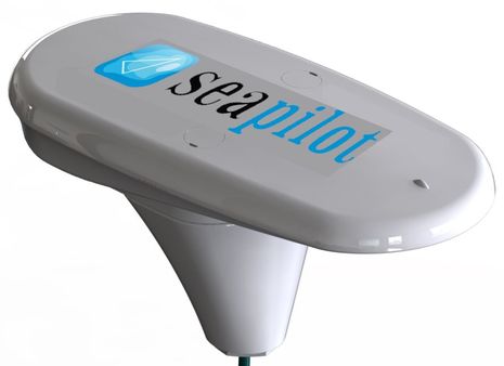
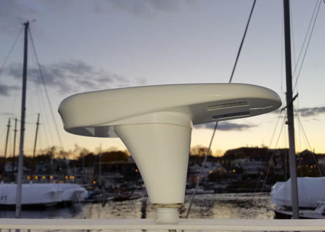 There’s lot to report from the Fort Lauderdale Show, but the calendar dictates that I first write about this Seapilot satellite compass. That’s because a startling 50% show discount is still available this week, so you can buy the Vector Compact-N NMEA 2000 model seen above for $500 simply by applying the code “FLIBS2015” in the shopping cart. The Compact seemed like a relatively good value at twice the price when I first discussed its features last November, and since then I’ve seen it perform pretty well on Gizmo…
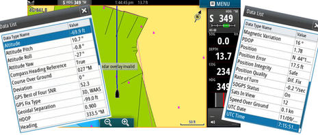 I don’t know why Seapilot is selling the Compact at half price — and all its Class B AIS transponders, too — but maybe it’s because many boaters don’t yet realize how much a GPS (GNSS) compass like this can do. It not only supplies a fast Heading source for autopilots and radar overlay, regardless of a vessel’s magnetic disturbances and without calibration; it also provides precision GPS positioning and Attitude information like Roll and Pitch. Except for Depth, all the nav data seen on the Simrad NSS7 evo2 charting screen above is coming from the Compact, and the Heading is very accurate even though Gizmo is tied up and therefore the Course over Ground (COG) is random.
And you can see even more Compact data output on the diagnostic list the NSS can show for any N2K source (though I don’t know what Simrad means by Attitude Yaw, which is the same as Rate of Turn, I think, and not mentioned by Seapilot). The sensor data seems reliable in all conditions, too, even with the test Compact mounted on Gizmo’s port spreader with lots of other antennas around and above it. In fact, I have often used it to provide smooth “gyro stabilized” Heading to Gizmo’s Simrad autopilot since I installed it in North Carolina last April.
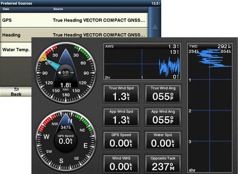 But I did sometimes test the Compact on the boat’s other N2K network, and you can see it here chosen as the preferred GPS and Heading source for a Garmin 741. And if I had thought to set up that Garmin 8212 screen better, you would see the Compact helping to calculate Ground Wind (because on most marine electronics, Heading is a component of Ground Wind but not True Wind, though that’s a different story).
 This Furuno NavNet TZT screen reveals Vector Compact data output details particularly well, but also seems to show a glitch. The Magnetic Variation here in Maine is West 16°, not East, and the mistake is not simply a poor translation of binary data that’s used for internal math, not for normal navigation display. The main TZT data boxes show a Magnetic Heading 32° different — 16 times 2 — from the Simrad, Garmin, and Raymarine screens all listening to the same Compact compass. So it looks like a Furuno problem, but then again Variation correction can be a tricky area of NMEA 2000, especially on a mixed brand network, and Furuno is one of the few vendors that even lets a user choose a source if there are multiple available. (And the same TZT will display accurate True Headings, so the glitch is not insurmountable.) {11/15: What I missed is that the Furuno TZT itself supplies Variation by default, and so the error seen above may be coming from the Seapilot Compact. See comment below.}
 Meanwhile, Gizmo’s test Raymarine a77 could not specifically identify the Vector Compact as a GPS source, but Ray’s Lighthouse operating system has long been weak at NMEA 2000 utilities (though getting better with every software update). Most networks don’t have four different brand GPS sources, and the a77 used the Compact data fine once I picked the right “unknown” source (or automatically). In short, the Seapilot Compact seems to offer solid GPS and Heading performance, but the complex data set in the background may not be understood perfectly by every N2K device. In fact, Seapilot updated the Vector Compact firmware to correct some minor issues since sending me the test unit, though updating requires returning the unit because no display with an SD card can apply it.
You also can’t calibrate a Seapilot Compact from a different brand display, because that just isn’t done over NMEA 2000 (except for some cases where the calibration values are kept within the display instead of the sensor, like Furuno). But there is generally no calibration needed if the sensor is installed well, and the Compact hardware makes that easy. Note in the top photo, for instance, the thin lock nut which lets you precisely align the Compact instead of messing with tape or thread adhesives. Note, too, that the last step is screwing the compass to the pole mount adapter from above, so there’s no twisty cable issue. The Compact can be flush mounted, too — and will practically disappear on many boats that way, because it’s so small and low profile — but precision first time alignment, or an intermediary plate, will be needed.
 But maybe you don’t want a GPS compass, and I’ll add that an even more inexpensive Simrad GS25 can provide sufficient Heading and GPS info to Gizmo’s autopilot, etc. How about a top-of-the-line Seapilot CTRX Graphene+ AIS transponder with NMEA 2000 and a built-in antenna splitter for $550? Note that Seapilot is the recreational brand of the AIS experts at True Heading. The 50% discount code “FLIBS2015” is purportedly good until Nov. 15 and also applies to the SeaPilot app, which recently got a weather routing module.




The Seapilot Vector Compact GNSS Compass looks very interesting. I wish they had provided an installation/user manual on their site.
Ben — Can you try a little experiment and see if the sonar on the TZT 2 will accept the “heave” PGN from the Vector compass and apply the corrections?
Sorry, Quitsa, too late; I’ve already removed the TZT as I prepare to haul Gizmo. But I really doubt that the Compact’s heave value — supposedly accurate to less than “30 cm (RMS)” — would get to the TZT or any of the N2K displays. I know that it wasn’t a standard PGN when I saw Furuno demonstrate how it could correct (or create) a sea-rippled fishfinder bottom with an SC30 in 2008…
https://panbo.com/archives/2008/07/furuno_sc-30_satellite_compass_so_sensitive.html
…and I see no sign that it’s in a standard PGN now, crazy as that may seem. For instance, there is no mention of Heave in the PGN list you can find in manual to the Hemisphere V104n GPS Compass, which is very similar to the Seapilot Compact, if not exactly the same:
http://hemispheregnss.com/Products/Products/Position-Heading/vector-v104e284a2-gps-compass-763
Ditto for the similar or same Simrad Professional HS60:
http://www.navico-commercial.com/en-US/Products/Gyro-Compasses/Simrad-HS60-GPS-Compass-en-us.aspx
Both those manuals — thanks for bringing that up, Anon — do mention a 1EFXX (Destination addressable) PGN that includes “GPHEV Heave” but that sure looks proprietary and it seems like even Simrad hasn’t made use of it in its own version of the compass.
Thanks Ben. It does get a little confusing on the heave data. The Furuno SC-30 interface box outputs the NMEA 0183 heave sentence, which seems to work with the sounder for heaving corrections per the manuals. It appears that it is only the NMEA 2000 PGN from the SC-30 that is in proprietary format. Thus in theory if you got the NMEA 0183 version of the Seapilot, it should work.
I would just get an SC-30 but they are pretty big, which I know is necessary to get high accuracy because of the geometry of the GPS sensors.
Someday all this stuff will be standardized….
I have a similar GNSS sensor – Airmar WX200 – and the above comments about Heave got my attention. It looks like PGN 129028 – “Altitude Delta, High Precision Rapid Update” is the only N2K PGN with altitude data.
Interesting that Furuno mentions correcting for heave – the only Raymarine mention of heave is in this sentence:
“Vessel maneuvering characteristics — A
vessel’s draft increases due to squat, trim, roll,
pitch and heave.”
The sawtooth depth contour has bugged me but I hadn’t thought about smoothing it out. Has there been any other manufacturer discussion about correcting for this?
Can this product measure leeway on a sailboat? How would that be transmitted?
I’ve asked Seapilot for advice on the Heave issue, but let me interrupt the conversation to note that Keith is probably the first person to use Facebook to place an authenticated comment on Panbo. Thanks, Keith!
In fact, if you look at the Panbo “Sign in” and “Sign up” pages you’ll see they are much improved. But what I’m really, really happy about is Panbo’s new Google custom searching. Try “heave Furuno” to see how fast and accurately it can find relevant past entries and comments. Panbo is more useful resource than it was a couple of days ago!
I would presume leeway would have to be a calculated value though this device should give you all the info you would need to calculate it since it would be giving accurate heading and COG data though will require quite accurate heading alignment/calibration. The nice thing I think it does output for any sailing performance monitoring is heel angle which can be quite helpful in providing more accurate target Boat speed data.
I would expect a program like expedition, would make good use of the heel, accurate heading and COG data to calculate leeway and provide more accurate performance analysis. I have never had the oportunity to use expedition with heel inputs, but from playing around I can tell that it will take the data in and make use of it if your polars are set up properly.
All of the newer Furuno sounders will correct for heaving with data input from an SC-30 or SC-50 Furuno satellite compass. The bottom contours are smoothed to the actual without the sawtooth effect from wave action. I have seen it in operation and it does work quite well.
Anon, I think it’s more complicated than that. To really capture the difference between how a boat is moving forward in the water and how it’s actually moving over the ground, you need a Heading/StW vector and a COG/SOG vector. A satellite compass can’t provide Speed through the Water, so that’s a problem right there.
Then there’s the fact that the sum of those two vectors is usually called Set and Drift, though it may contain an element of Leeway. How can sensors differentiate between water moving sideways under a boat and the boat slipping sideways over the water? I think that takes a multi-directional speedo, and I’ve only heard of one on a sailboat:
https://panbo.com/archives/2012/05/nortek_doppler_velocity_log_measuring_pumas_leeway_across_the_pond.html
So I think that Leeway is generally an estimated value based on experience with a boat at different angles of heel and points of sail. As you note, the Compact GPS compass can fill in a lot of the table variables, but I don’t think any device can simply calculate leeway (except aboard Puma). On the other hand, if a program like Expedition is accurately set up to estimate leeway, maybe it can also correct normal Set and Drift calculations for Leeway 😉
Ben, I’m impressed, even if you drive a trawler 🙂 Your sailing roots show through!
Thanks, Eric. Good to know I made sense to someone!
I’ve been using Simrad HS60 for a months time and it seems to perform very well. I’m using it as GPS and as autopilot compass.
I don’t think a specific Heave PGN is needed. There are two PGN’s giving altitude. PGN 129028 is the one I expect will be used for heave compensation.
PGN 127257 Attitude Provides a single transmission that describes the position of a vessel relative to both horizontal and vertical planes. This would typically be used for vessel stabilization, vessel control and on-board platform stabilization.(1 Hz update)
PGN 129028 Altitude delta, high precision rapid update. The“Altitude Delta, High Precision Rapid Update”Parameter Group is intended for applications where very high precision and very fast update rates are needed for altitude and Course Over Ground data. This PGN can provide delta altitude changes down to 1 mm, a change in direction as small as 0.0057°, and with a delta time period accurate to 5 msec. (10Hz update)
I’ve bought a Kvaser Leaf Light V2 Can bus to USB interface to be able to configure HS60 using Vector PC, but it don’t work. Kvaser upgraded the Leaf Light to V2 one and a half year ago, but Vector PC still don’t support V2. With Vector PC Leaf Light V2 I can see on the LED that it don’t even try to access the Can bus. I tested also Pocket Max and it connected to Can and started to search, but didn’t find any supported GPS receivers. I don’t know if Pocket Max is supporting HS60, but I know Vector PC does if using the old Kvaser Leaf Light version. The current Vector PC version is about 1 year old while Pocket Max is about 5 months old so I assume Hemisphere just need to recompile Vector PC with the latest Kvaser drivers to include support for Leaf Light V2. I’ve contacted both Simrad and Hemisphere support regarding this.
abbor — Do you have a Furuno sounder with the heaving compensation function that you have tried with the HS60?
In my case, the question I asked was if Ben had tests to see whether the Furuno sounders can use the data from a non-Furuno satellite compass such as the Seapilot or the HS60 that you have. The smallest Furuno compass is the SC-30, which is more than twice as big as the Seapilot and four times the cost.
No, I’m running a Simrad system so I’m still waiting to get heave compensation.
Hey Ben – thanks for the tip about the Seapilot AIS. That was not on my radar screen and it looks like its what I’m looking for. I just tried to order one before the 15th, but the discount code is not working. Was there a typo?
Hi Peter, The “FLIBS2015” discount code was definitely working when I wrote this — I tried it — but it’s not working now.
And here is what the sale email said:
“Use the discount code FLIBS2015 to buy our products below directly from our shop shop.seapilot.com with 50% discount or email [email protected]. The offer is valid until Nov 15 2015.”
So it makes sense that the code is not working today, but it should have worked for you yesterday. I suggest that you email or call Seapilot. The Seapilot store lists a Swedish number, +46 8 622 26 60, but True Heading USA lists this number: 1-844-444-3797
I just added a bold faced correction to the part above about a possible problem with the way the Furuno TZT handles the Seapilot Compact Variation value. It turns out that the TZT itself can provide Variation and does so by default. Plus, since I can’t tell where any other display on Gizmo is getting Variation, they all may be supplying it themselves or getting it from some other source than the Seapilot. In other words, it may be the Seapilot itself that caused the problem seen on the Furuno screen, but the only way you’d see it is by forcing the TZT to use the Seapilot for that value.
At any rate, Furuno is looking into it and already sent me a screen photo showing that a TZT can get correct Variation from a True Heading Vector Carbon sat compass, and they are testing a Compact. Like I said, Variation is a tricky area of N2K.
I checked the rebate code Friday evening, and it still worked then.
Thans Ben, will do.
FYI – Seapilot extended their FLIBS2015 discount code until Friday 11/20. Also, I found out Seapilot has a 2 year warranty, and for the AIS units, they say the units are water resistant, but not waterproof.
Hi Ben,
Sorry for earlier anon post — I thought I was logged in — speaking of which, did you change the login options for comments? I thought I used to log in with my google account.
To get back to leeway calculations, yes, any calc will need Boatspeed (BSP) through the water, but most sailboats will have that already, especially if looking for some decent performance prediction. The calculated leeway will also assume there is no current (set/drift) so would have limited value in a place like Newport or parts of Pen Bay.
My point was that by adding accurate heading data (non-magnetic), it would help a program like expedition to calculate a leeway. Having Heel data could also help such a calculation in terms of allowing a calibration correction for heel angle since we know that leeway will increase as heel increases.
It surely wouldn’t be perfect, but it could be an interesting item to track when doing performance data collection.
Hi Gram, I’d like to add Google sign-in but my web guy says that will have to wait a bit while Google transitions its system some way. But we did add Facebook sign-in, as you apparently discovered, and also Google Custom Search inside Panbo, which tickles me no end. For instance, check out how well Google finds your many contributions over the years:
https://panbo.com/search.html?q=Gram%20Schweikert
Regarding “Heave”: The True Heading/Seapilot team at METS told me that Heave does not have a standard PGN in NMEA 2000, but it is being put out in that proprietary PGN I spotted in the manual. So a MFD manufacturer could conceivably get Heave from the Seapilot Compact (though apparently none has done the programming so far).
They said that the same is true for NMEA 0183 (and that Furuno had to write their own 0183 Heave message).
On the other hand, the “PGN 129028 Altitude delta, high precision rapid update” Abhor mentions above sure sounds like Heave to me — i.e. not absolute Altitude, which is vague relative to sea surface, but precise and fast differences in Altitude — so I remain a little unsure about what’s going on.
The Furuno SC-30 manual says it outputs PGN 065280 and the TZTL 15 manual says it accepts that same PGN, which is the Furuno proprietary heaving correction data.
The Simrad HS60 outputs the altitude change PGN 129028, which sounds very similar.
What I can’t tell from the manual is whether the TZTL 15 is able to display the heaving (altitude change value) in a data box since it is able to display anything on the network so far as I can tell. I know it will display pitch, for example, as it shows that data from my Airmar GH2183.
I have heard some rumblings that Simrad may introduce heaving correction for their sounders, which presumably would be done using the output from an HS60.
Wish I had one of each of the SC-30 and HS60 or Seapilot to put on my network to see what happens. See, we all want to be Ben!
The discount code worked for me on 11/13 and my AIS arrived yesterday. SeaPilot have been extremely communicative and helpful. The built in antenna splitter was a big attraction for me. I’ll report back after installation.
Heading Sensor Shootout
With all these new small and supposedly highly accurate heading sensors coming out, it would be really cool if there was a side by side shootout
Airmar GH2183
Vector Compass
Simrad Precision 9
Point-1
Raymarine Evolution
Lots of innovation that is hard to compare
Don’t wait for a shootout. These units are so close it would be very hard to test them. With the exception of Navico Point 1. It’s a 10 Hz heading sensor plus GPS, but the emphasis must be on the GPS, since Navico says “not recommended for use with MARPA or autopilot”.
Airmar GH2183, Airmar H2183, Navico Precision 9, Raymarine EV1 and EV2, Maretron SSC300, and Seapilot Vector Compass Compact-N all claim about 2 degrees accuracy in very dynamic conditions. Seapilot is a different technology, the rest all use a 3 axis compass, 3 axis accelerometers, and 3 axis rate gyros. And all have a heading update rate of 10 Hz (EV1 and EV2 just say “fast” and “good for MARPA and radar overlay”).
So what to choose?
I have a Garmin system today and will probably get a Garmin Reactor autopilot(hydralic).
But Garmin will not accept a GPS Compass input.
Shall I get a autopilot that accept GPS Compass input to get better accuracy in the autopilot control or is that debatable?
It’s for a preformance sailing catamaran of 42´.
Any idee?
https://www.facebook.com/Catamaran.SY.Aset/?ref=aymt_homepage_panel
Quite debatable, I think, Peter. Garmin has had good autopilots since they acquired Nautimatic in 2007…
https://panbo.com/archives/2007/03/garmin_buys_nautamatic_sweeeeet.html
…and they’ve continued to improve them over the years. Testing autopilots side by side is very hard, and might not matter unless the test boat is quite similar to your own, but my impression is that while all the major manufacturers have improved their ap systems a lot (heading sensors included), Garmin’s is still quite good.
Maybe a reader who has used one on a fast catamaran will speak up, but I don’t think you’d be taking a big chance. You could also try to ask Garmin with some information about how your cat steers in various conditions, but it may be hard to find the right person.
Peter the fact that the GPS compass is more accurate is true butt I don’t think you have more benefits of it. the reactor also measures the pitching and rolling of the boat and it is fast to, Garmin uses it for its Marpa and the panoptix forward looking sounder what a GPS compass can’t do.I mounted several reactors now and with the latest software steering is good also on sailing boats and semi planning boats. further steering on the route and auto guidance route works the best with a Garmin pilot so when you already have Garmin on your boat stick with the Garmin pilot is my advice. Take the reactor mechanical with an reversible pump not the piston pump from Garmin it self.
Of course I’m in the market now for one of these compasses. If anyone sees the $500 deal again, please let me know.
Matt