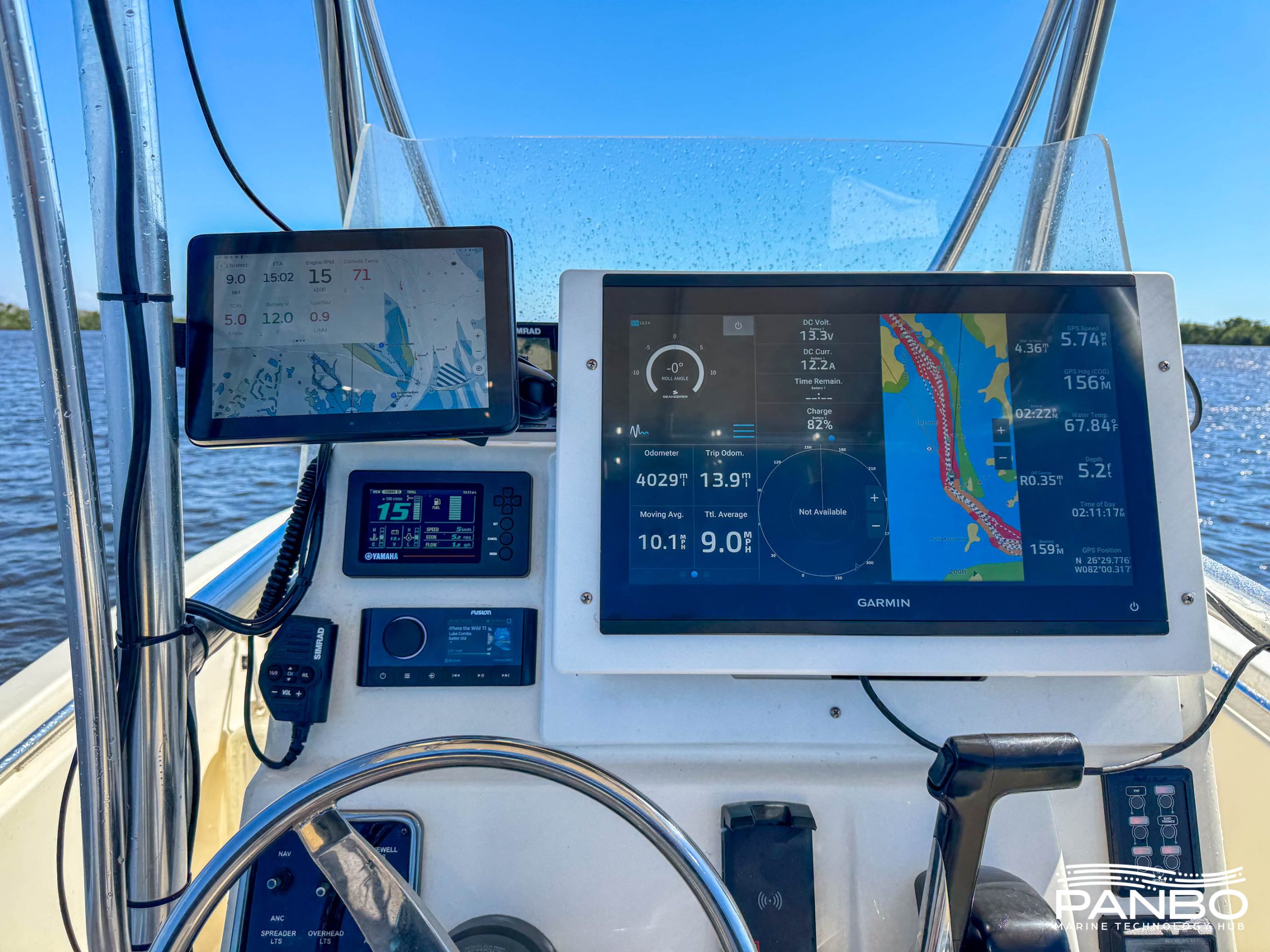
I'm not the sort of guy who usually spends time looking for diagrams and explanations regarding a field like Market Intelligence (MI), but I'm pretty darn sure that the Marine Electronics (ME) industry could really use some help from such specialists. That's why I'm very pleased to introduce a new company called Marine Technology Advisors, whose entire focus is market intelligence. And I'm super pleased to add that Panbo is involved, and that you -- the readers of Panbo -- can really help. It's a win-win-win situation, I think, and I'm excited. You can read more details below, or just dive right into MTA's first Panbo marine electronics survey.
From Dan Corcoran in Valencia, SP: Because of the great speeds of the two sailboats, this America's cup will be held further from shore and on a longer race course than those of recent memory, causing tremendous challenges communicating on the race course. Even the judges are unsure that they will be able to communicate successfully in boats equipped like the one pictured above with retractable towers for VHF communications and satellite dishes.
Jeff Siegel of Active Captain (discussed here recently) is the first developer to submit a mock-up showing what his software might look like on an iPad (in response to my challenge), and it's so intriguing it deserves a quickie entry. It hadn't even occurred to me that POIs could be neatly listed in the order a cruiser would encounter them along a given route. They can be filtered, too; in this case only marinas offering special deals are showing. I believe those deals are examples of the co-op advertising AC mentioned in their recent newsletter, and they look like a win-win thing to me. Altogether, the Active Captain Companion app, which will likely be free, sure looks like a good use of the iPad's portability, connectivity, screen size, and extra interface options. Jeff plans something similar for Android phones and tablets using the Layar environment. I'm hoping we'll see more marine mock-ups for all these platforms.
I think it's safe to presume that Navionics Mobile Marine is the best selling iPhone charting app in the U.S. and many other countries. In fact, as I just wrote in an April Yachting article, many iPhone boaters consider it a "no brainer" even if they also use other nav apps. But lookee here, they've rebuilt the entire thing, substantially improving both features and value. Today you can buy the US East Marine and East Lakes versions for $10 each, a steal really, but they are 166 and 535 megabyte files, which is a bit of an inefficient pain for all concerned. By contrast, the new $10 Marine&Lakes:US will be an easily updated 2 MB because it doesn't come with data. BUT you'll be able to download charts and lake maps for anywhere in the entire U.S., quite easily, and fresh direct from Navionics' own servers. The greedy download illustrated above -- note the chart and POI detail of Newport -- took about 10 minutes via my home WiFi network, and a much smaller download went fine even over AT&T's poky Edge service. And there's more...
When MaxSea bought Nobeltec from Jeppesen last Fall, there were hints that one somewhat counter-intuitive result might be a new partnership between Furuno/MaxSea and Jeppesen, but I didn't think we'd see results this quickly. Today Furuno announced that NavNet 3D displays will soon support a worldwide portfolio of "C-Map by Jeppesen" MapMedia charts, in addition to the NOAA raster and vector and "Datacore by Navionics" MapMedia charts they already support, thus making them "the most versatile" chart plotters available. It sounds great, but there are some details to note...
Last summer I tried both SeaView and ScanStrut radar mounts, and was impressed with both. I also got the sense that these are two able companies in healthy competition. No surprise then that SeaView has just introduced electronics pods not unlike the ScanPod (originally called the DeckPod) that I also tested last season. That big ScanStrut housing held up pretty well to the weight of a Raymarine C140 though it did jiggle a bit in rough going and I did have to adjust the clamp once. SeaView's design, above, looks to have two clamps and maybe more bearing surface, and I'll be curious to get a feel for its range of motion and rigidity when clamped. Maybe in Miami? Meanwhile, ScanStrut has moved into cable deck seals...
Among the new products to be shown at the Miami Boat Show next week, FLIR just announced both a lower cost fixed M-Series and two new higher-end hand-held First Mate models. The new M (no model # yet) packages a single 320x240 thermal cam with the same excellent bullet casing and Ethernet controller(s) that I tested as the M-626L last fall, with dual payload 640x480 thermal and low light cams. The purported retail of the new cam will be $12,000, which will likely mean an under 10g street price judging from some outlets for the existing models. It's great to get the price down on this valuable safety tool, but it reminds me of the occasional value I saw in also having the low light camera. The shot above was taken in daylight, but the thermal camera would have seen out the harbor as well as it does at night if it weren't for the downpour. After the break, you'll see what it missed...
The smaller, cheaper Iridium short-burst data (SBD) modem I heard about at Fort Lauderdale is now official and, wow, doesn't it look able to "disappear into as many marine devices as possible!" It even has GPS input/output ports so that it and the modem can easily share a dual-mode antenna. Hardware and service costs aren't specified but Iridium is claiming that the 9602 will have "the highest value in the industry." I, for one, can't wait to see devices like the Spot Messenger that are global and bi-directional, not to mention what the MFD and marine security/tracking developers might do with the 9602. And I'm glad for Iridium that it's got this and OpenPort going on, because it sure looks like Inmarsat is finally about to attack its dominance in the portable satellite phone department...
Weird world that it is, I first learned of EasyBailer via Twitter, even though the "factory" is just down the coast. Last week I stopped in and met "CEO" John Bianchi in his shop full of small boats, including an impressive plank-on-frame Rangeley Guideboat he built himself. Thus I wasn't surprised to see how neatly put together his solar-powered dinghy pump is (click above for detail). And I consider myself somewhat expert on this subject as I tried to assemble a similar system myself with poor results...
The tidal wave of interesting iPhone boating apps rolls on! The screen at left above (click for bigger) shows a beta version of Memory Map's upcoming charting app and I can tell you that it already handles NOAA raster charts and topo maps with speed and smoothness I didn't think possible on plain 3G hardware. At middle is the brand new Ships Ahoy!, a $3 AR (augmented reality) relative to Ship Finder and the other AIS viewers that lets you just point an iPhone 3Gs (you need the compass) toward a vessel or two to get their names and details (if the area is covered by a network receiver). And finally there's Navionics' neat new Ski:US, which admittedly has nothing to do with boats but does speak to this big marine company's big commitment to mobile apps. It happens to have my local Camden Snow Bowl among the so-far-limited ski area coverage, and it works great. In that screen shot I'm playing back the tracks (in yellow) I cut right after last week's big snow dump, in particular the --- MPH moment I lost board control in a huge drift. All these possibilities, and lord knows what else, will expand if Apple introduces a 4.0 version of the iPhone operating system this afternoon. But of course the bigger questions swirl around the Apple tablet, or whatever they decide to call it...