Yearly Archive: 2010

Lowrance DSI , & Navionics goes MicroSD (Raymarine included) 10

Lowrance DSI , & Navionics goes MicroSD (Raymarine included)

Lowrance_Elite-5_DSI.JPG

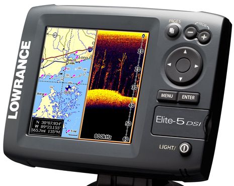
Last week Lowrance announced the Elite-5 DSI and some related fishfinder/plotters, and while they’re unabashedly aimed at freshwater fishermen, there are at least two things about them of interest to others.  DSI stands for DownScan Imaging, which seems to mean that Lowrance has isolated the high resolution down looking portion of StructureScan into an even more inexpensive form.  That means a transducer that can ping at 455 or 800 kHz, trading detail for depth and breadth.  Aren’t lots of non-fishing boaters — like gunkholers and just plain curious monkeys like me — also interested in better resolved bottom imagery, even if it’s only to 100 feet or so?  That’s why I installed StructureScan on Gizmo even though the thru-hull transducer wasn’t ready yet, and I can’t wait to seriously experiment with it (soon!).  The new Lowrance plotters will also be the first I know of to use MicroSD chart cards…

SimNet network testing, & more NSE goodies 34

SimNet network testing, & more NSE goodies

Simrad_SimNet_parts_cPanbo.JPG

Years ago I gave Simrad grief for developing its own NMEA 2000 cable and connector system, called SimNet, instead of going with the DeviceNet standard as NMEA wanted.  When NMEA 2000 was just getting started, SimNet confused end users and installers alike, as would Raymarine’s SeaTalkNG, and Lowrance’s first version of LowranceNet, etc.  I remain leery about proprietary cabling but I’ve never heard of performance issues with SimNet, and I’ve never had any trouble integrating SimNet devices into standard N2K networks, using male versions of the adapter cable seen above.  Until this week, however, I’d never tried it the other way around, building a SimNet network and adding in other manufacturer’s N2K devices as desired.  No problems so far…

SRT mini AIS modules, & trouble from the East? 14

SRT mini AIS modules, & trouble from the East?

SRT_Class_B_n_SART_modules.JPG

I mentioned SRT’s amazingly miniaturized Class B and SART AIS modules back in May, but seeing is believing. In that aluminum EMI enclosure at left is a Cobalt Class B transponder complete with precision GPS engine and power supply (the board itself is inset)!  What we’re looking at is smart phone technology applied to a very specific marine use, and it shouldn’t be too long before these modules make AIS less expensive, more powerful, and much easier to integrate with other devices.  But I’m also hearing about a dark cloud looming as the marine world rapidly adopts AIS…

Camden NOAA chart changes, the questions 19

Camden NOAA chart changes, the questions

Camden_Channel_cPanbo.JPG

So I’ve done more research into the various small issues I’ve noticed regarding recent NOAA chart changes to Camden Harbor (discussed most recently here).  Let me emphasize small, and also my appreciation of NOAA as an agency with vast tasks and limited resources.  The intent of charting the Outer Harbor channel buoys maintained by the town, and updating dock details in the crowded Inner Harbor, is excellent; nearly every day I’m around the harbor I hear visiting boats getting guidance about these matters via VHF.  But the chart update issues certainly bring up questions about who’s responsible for what and NOAA’s quality control system, as well as ones regarding intentional and unintentional chart presentation details.  And they probably apply to the official charts all around the country…

RMC Island 40, off the grid house boating 7

RMC Island 40, off the grid house boating

IMG_8378-1.JPG

That somewhat odd looking “waterborne structure” is Robinhood Marine Center’s first Island 40, designed to give renters who may only have small boat skills a wicked nice Maine cruising harbor experience, as in swinging on a mooring with seals, osprey, lobster men, and cruisers for neighbors, with good exploration possibilities in all directions, and with a pleasant “destination” marina nearby.  And it’s a hoot!  I’m sitting at the Tessie Anne’s spacious aft dinette right now, enjoying a cool sea breeze and the use of a well thought out battery/inverter/solar panel system…

Garmin 7000 and AIS 600, some install details 27

Garmin 7000 and AIS 600, some install details

Garmin_AIS_600_back_cPanbo.jpg

Today I checked out some just-received Garmin gear prior to installation on Gizmo, and I noticed some nice little changes.  For instance, this AIS 600 has an automotive blade fuse instead of a glass cartridge and its relatively flimsy holder (which should all vanish from boats, I think).  And Garmin’s included NMEA 2000 cable is thicker than it used to be, indicating, I’d guess, some added EMI protection (needed to get NMEA certification, pdf on that subject here).  Garmin has also started using separate split screw collars — seen on and off in the photo — on lots of connectors besides Ethernet, which means easier to run cables (in some situations).  Note, too, the most LED indicators I’ve ever seen on a Class B transponder.  Tentatively speaking, the thing seemed to work pretty well too…

Paneltronics AC load shedding, smarter power 7

Paneltronics AC load shedding, smarter power

Paneltronics AC load shedding module.jpg

Paneltronics new load shedding system is somewhat related to my battery/monitor/charger travails.  Boaters of all sorts are struggling to management their electrical appetites and the line between electrical and electronic is getting fuzzy indeed.  And there are all sorts of us; I have no need for AC load shedding personally, though this device is unique in that it’s aimed at boats like Gizmo

Panbo logo, & Gizmo lit for the 4th 8

Panbo logo, & Gizmo lit for the 4th

Panbo Logo draft.jpg

It’s just a draft  — artist I’m not — but maybe someone out there in Panbo land can craft this into something fun for a hat and business card?  The graphic idea is an electronic wave turning into an ocean wave, but I’m open to another design…as long as it floats some boats.  Seriously, the first hat (a nice long billed khaki cap) will be yours, plus my undying gratitude.  (If it would help to start with my draft creation in vector form, you can download it as an .ai file.)  Homework is completely optional, of course, and you, like me, may have a holiday to celebrate…

Maretron DSM250, N2K ups & downs 25

Maretron DSM250, N2K ups & downs

Maretron_DSM250_dual_depth_cPanbo.JPG

There’s a lot to say about this screen and how the values got there, or didn’t, but what I like the most is how Maretron’s DSM250 is displaying the outputs of two NMEA 2000 depth transducers at once, and that I was even able to name their data windows in an informative way.  I think the screen will be useful in some tight gunkholing situations, and would be even more so on a larger vessel or a multihull.  Unfortunately this level of N2K data management is not yet available elsewhere, unless I’ve missed something…