Category: Navigation

Argonaut’s giant A615 Android tablet, and a Panbo reader survey 20

Argonaut’s giant A615 Android tablet, and a Panbo reader survey

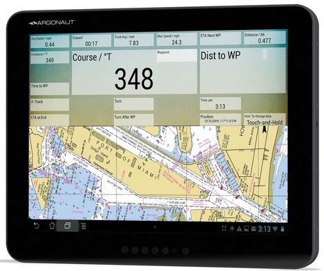
Argonaut_A615_Android_15-inch_marine_display_.jpgThis is different! While the new Argonaut A615 Smart Monitor has several of the marine display features the company is known for, it can also serve as a large Android tablet. So with its 360° waterproof enclosure, bonded Tflex transflective LED-backlit LCD, and Quad Core ARM processor you can have fast standalone chart plotting on a 15-inch screen in your cockpit or on your flying bridge using only 20 Watts of 12 or 24 volt DC power. And of course that’s not all…

METS 2013: Glomex WeBBoat, fingers on Garmin and Simrad, and more 5

METS 2013: Glomex WeBBoat, fingers on Garmin and Simrad, and more

mets_2013_glomex_webboat.jpg

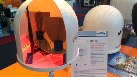
The Marine Equipment Trade Show 2013 held in Amsterdam last week lived up to its reputation again. The trade floors were packed with exhibitors, and I was told that the booths were packed with visitors on the first two show days. Fortunately, it wasn’t as busy during my third day visit and I could move around easily — if not as anonymously as before; at Garmin I was welcomed as “Hey, you’re the guy from Panbo!”  Ben has already reported on Garmin’s down- and side scanning sonar, xHD radomes, etc., plus the new Simrad NSS and B&G Zeus2 Series, but I got to see the new products in action and there was much more to cover, like that neat Glomex WebBoat WiFi/3G access point seen above…

Furuno MUxxxT monitors, Hatteland X Series, and TimeZero Coastal Monitoring 7

Furuno MUxxxT monitors, Hatteland X Series, and TimeZero Coastal Monitoring

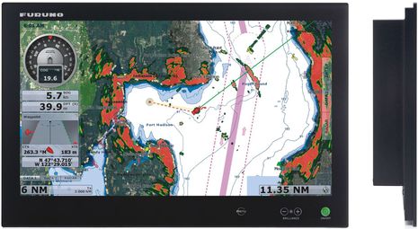
Furuno_MU240T_monitor.jpgFuruno’s new multi-touch MUxxxT monitors are intended to play nicely with NavNet TZtouch MFDs. Using its DVI output, the TZT9 or TZT14 can send a screen mirror to the wopping 24-inch widescreen MU240T above — at 800×480 and 1280×800 pixels, respectfully — and USB takes the touch commands back to the TZT (using a standard Windows driver). Meanwhile the TZT Black Box has enough DVI and USB ports to drive two of these glass-bridge-style monitors (and two keypads, like the one KEP recently introduced or the one Furuno is purportedly working on)…

Simrad NSS evo2, multi-touch 7-inch to 16-inch and beyond 48

Simrad NSS evo2, multi-touch 7-inch to 16-inch and beyond

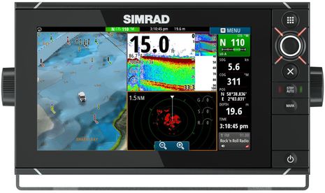
Simrad_NSS9_evo2_new_11-13.jpgAt METS this morning,  Simrad announced an evo2 update to the NSS Series and quite an update it is. The new multi-touch wide screen models will come in 7-, 9-, 12- and 16-inch sizes and since they are close family in every way to the recently discussed NSO evo2, a boater will be able to mix and match bright, glass-bridge-style displays from 7 to 24-inches. And while NSS evo2 can network with Simrad’s radars, sonars, SonicHub audio, WiFi 1 etc., all four sizes come with “embedded CHIRP enabled Broadband sounder and StructureScan” (which can probably network out to the whole family)…

Holy Garmin cow: SideVü/DownVü, GPSMAP 800/1000, GMR 18/24 xHD, Meteor 300, gWind & the Helm app 44

Holy Garmin cow: SideVü/DownVü, GPSMAP 800/1000, GMR 18/24 xHD, Meteor 300, gWind & the Helm app

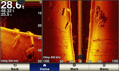
Garmin_SideVü_DownVü_800_kHz.jpgGarmin is purportedly announcing nearly fifty 2014 marine products today!  A lot are related to the company’s new ability to offer the high resolution down and side scanning that’s become so popular with freshwater and near coastal fishermen (and curious gunkholers like myself). Soon the relatively easy-to-understand (and fit-on-a-small-screen) down view will  be availiable in new echo dv fishfinders and echoMAP dv fishfinder/GPS combos that will then better compete against similar products from Lowrance, Humminbird, and Raymarine. Moving up the cost curve you’ll find CHIRP-assisted DownVü and SideVü, which look wicked sharp in the screenshot above (imaging what’s likely the remains of a bridge in a man-made lake)…

Raymarine LightHouse II, the paper chart lives on 21

Raymarine LightHouse II, the paper chart lives on

Raymarine_LightHouse_II_w_NOAA_raster_chart_cPanbo.jpgIsn’t it interesting that just after we learned that NOAA will no longer print traditional paper charts, Raymarine announced that all its current plotters will soon be able to use the digitized ‘raster’ equivalent of those same NOAA charts? The “completely redesigned LightHouse II” software that will make this entirely free new feature happen is due out in December, but I got on the water with a beta version last week. I was impressed with how well the raster charts looked and how well they panned and zoomed, even in beta, and there’s much more to like about LightHouse II…

FLIR M-Series nav cam test, Raymarine integration appreciated! 12

FLIR M-Series nav cam test, Raymarine integration appreciated!

FLIR_M-618CS_test_Slew-to-Cue_cPanbo.jpgI’ve long thought that the usefulness of a navigation camera would increase significantly with tight integration to a boat’s principal navigation system, and now I’m convinced. When I redid Gizmo’s antenna mast last spring, I got to top it off with a powerful FLIR M-618CS dual camera system that was sometimes very handy as I cruised up the coast. But when I finally got around to integrating it with the Raymarine e-127 above, its safety value took a quantum leap. While it’s obvious from the lower-right camera window that this particular test day was very clear, also obvious to me was the camera system’s potential when I can make it quickly pan and tilt to any spot on the chart screen, on which it will stay locked no matter how Gizmo manuevers and — in the case of MARPA and AIS targets — regardless of how the target moves…

Improved current data? Let the IHO know you care. 7

Improved current data? Let the IHO know you care.

IHO_Surface_Current_Survey_page_cPanbo.jpgMaybe you too have an opinion about how predicted currents should be overlaid on electronic charts?  Well, the International Hydrographic Organization (IHO) is developing an S-100 specification for “the delivery and presentation of navigationally significant surface currents” and right now they’re running a online survey of all interested parties. What waters do you care about (coastal for me)? What prediction frequency would you like? Are you willing to pay? How should the data look? And more…

NMEA 0183 lives: Digital Yacht GP150 DualNav & Furuno IF-NMEA2K2 Converter 12

NMEA 0183 lives: Digital Yacht GP150 DualNav & Furuno IF-NMEA2K2 Converter

Digital_Yacht_GPS_150_Dualnav.jpgI’ll write soon with NMEA Conference details of the futuristic (and unfinished) NMEA OneNet standard, but I also left San Diego with the strong impression that the good old NMEA 0183 standard is still very much alive. One interesting example is the new Digital Yacht GPS 150 DualNav, which earns its last name for its ability to receive more than one set of positioning satellites at once — already active GPS and GLONASS in particular, more coming — and to then deliver more accurate L/L, COG & SOG than can be gleaned from just one GNSS system.