Category: Navigation

Wow: Raymarine e9, e12, c9, c12, ClearPulse & VoyagePlanner, all new 33

Wow: Raymarine e9, e12, c9, c12, ClearPulse & VoyagePlanner, all new

Raymarine_UK_Jan-21-2012.jpg

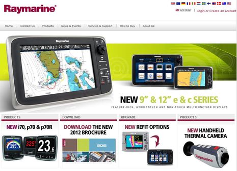
I’m surprised because I thought Raymarine was holding off a slew of new products for the Miami show in mid-February, but today we learned that Ray’s UK site has put details on the e9 and e12 big brothers of the e7 launched last summer, as well as new c9 and c12 MFDs that are very like similar to the e Series but without the touch control. Which is a lot, but not all…

Jeppesen C-Maps, Coastal Explorer 2011 & Plan2Nav 0

Jeppesen C-Maps, Coastal Explorer 2011 & Plan2Nav

Coastal_Explorer_2011_C-Map_beta_cPanbo.jpg

If you don’t cruise outside the U.S. it may not matter, but Coastal Explorer users who do seem quite excited that the PC charting program will soon support the worldwide portfolio of Jeppesen C-Map Max charts and maybe even NT+ cards. You can hear the enthusiasm, and learn a lot of detail about how support will work, by checking out this CE Beta testing forum entry. Better yet, if you already run CE 2011, you can download the Beta from the same page and then use its rich chart management features to download some of C-Map’s generous demo cartography…

Lowrance HDS Gen2, with StructureMap! 14

Lowrance HDS Gen2, with StructureMap!

The breaking news today is that Lowrance is out with the new HDS Gen2 multifunction display series, and it has enough processing power to support an interesting new feature called StructureMap. Of course you...

Simrad Broadband Radar 4G, hand’s-on #1 41

Simrad Broadband Radar 4G, hand’s-on #1

Simrad_NSE12_w_4G_radar_Camden_Harbor_cPanbo.jpg

I’ve looked forward to testing Simrad’s new 4G Broadband Radar since I saw it demoed in Fort Lauderdale. And how timely that I got out with it and the rest of Gizmo’s test radars over the weekend. Tonight I’m reprising my Seven Sea’s University radar webinar, and now I’ve got fresh material!  (No hard sell meant, but Panbo readers can get the SSCA discount by using the code “Gizmo” and note that you can watch the webinar any time in the next few weeks even if you can’t make it tonight). Plus it’s been weirdly warm here for early December, so I had a pleasant cruise even if almost all those finely targeted Camden Inner Harbor floats are empty in anticipation of what is surely coming…

ActiveCaptain route sharing: dangerous, useful, or perfection? 43

ActiveCaptain route sharing: dangerous, useful, or perfection?

ActiveCaptain_route_share_cPanbo.jpg

When I first heard about ActiveCaptain’s plan to enable route sharing amongst it users, it was via a group email from a very experienced bluewater cruiser “in absolute shock that a boat owner/skipper navigating a boat through unfamiliar waters would use somebody else’s waypoints.” I posted the whole note for discussion in the Forum, but only AC developer Jeff Siegel and I participated. Well, now route sharing is fully enabled at the ActiveCaptain site, as illustrated in the screen shot collage above, and I still don’t understand why anyone would object, particularly given AC’s careful implementation…

EarthNC: routing, NEXRAD, & Baron XMWX 11

EarthNC: routing, NEXRAD, & Baron XMWX

EarthNC_routing_cPanbo.jpg

I use the iPad version of EarthNC fairly often because I still like how it can overlay and detail NOAA weather buoy and forecast info, a feature it had when I first tried it. I also like how the quilted NOAA raster charts look on a pad (but then again I’m an old guy). Now EarthNC has added a pretty full featured route-making routine to its iOS version, as I tried to illustrate above by laying out the San Diego America’s Cup course I’ll be seeing up close later this week (I’m so excited). Note how I was able to easily type in waypoint names, and what you can’t see is how easy it is to move one, or delete it, or add a new one along a track line…

FLIBS 2011:  Geonav autorouting, from C-Map & Navionics 2

FLIBS 2011: Geonav autorouting, from C-Map & Navionics

Geonav_auto_routing_Navionics.jpg

FLIBS was my first chance to see the autorouting capabilities of C-Map 4D in action, and I liked what I saw. And not only is Geonav the first to make the feature available but it’s also the first to enable a similar autorouting feature from Navionics (which I wasn’t even aware of). As with other “Dual Fuel” chart features, Geonav tried to make the interface on the G12 (and G10) the same so that users switching between C-Map and Navionics cards aren’t confused. That’s why the details of the menus above and below are the same no matter which type of chart you’re using…

Navico Broadband Radar 4G, the launch demo 29

Navico Broadband Radar 4G, the launch demo

Simrad_4G_radar_launch_FLIBS2011_cPanbo.JPG

Holy cow!  The just-announced-today Lowrance/Simrad 4G Broadband Radar may look just like the original BR24 and its 3G upgrade, but there’s some astonishing NEW technology under that dome. In fact, Navico engineers seem to have overcome what I thought was an immutable law of radar physics, that beam width is purely a function of radar antenna length. I understood how the original FMCW solid state transmit technology — which is like CHIRP sonar — could produce better range resolution, but the BR24 and 3G are still limited to a 5 degree horizontal resolution just like all the other radomes in that 20″ size range. Not 4G!…

Raymarine i70 vs Garmin GMI 10,  mission accomplished? 16

Raymarine i70 vs Garmin GMI 10, mission accomplished?

Raymarine_i70_and_Garmin_GMI10_compared_cPanbo.jpg

A bigger and at least as bright a display? Check!  Able to show vaguely as many NMEA 2000 data fields in vaguely as many ways? Check!  Also manageable with a clean and intuitive interface? Check!  Don’t take me too seriously as I’ve only tested the new Raymarine i70 for maybe an hour now, but it’s no doubt an impressive parry at the venerable Garmin GMI 10…