Garmin’s new ActiveCaptain Community site, what’s good and what’s not?
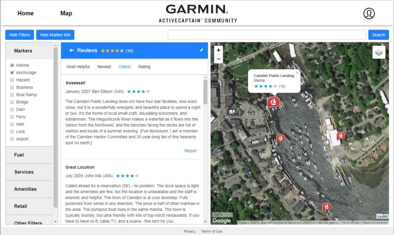
I am a long time fan of ActiveCaptain boating info. In fact, I’m pretty sure that my January 2007 Camden Public Landing review above was one the very first, as I was simultaneously writing about AC’s inception here (and at Power & Motoryacht). Now the AC database and user community are both huge, but many of us “captains” are struggling with Garmin’s very recent and complete rebuild of the service. In this entry I’ll share what I’ve learned about the new ACC website, hoping for more pros and cons from readers (and meanwhile, Ben Stein is working on an entry about the state of third-party ACC app support).
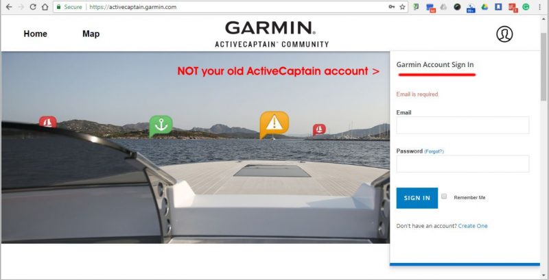
To start, it’s important to understand that Garmin has renamed the original AC crowdsourced data system as the ActiveCaptain Community (ACC). The distinction already confused existing AC users when Garmin introduced its ActiveCaptain app, which — while it does include ACC data viewing among its many functions — is designed almost exclusively for owners of Garmin marine navigation systems. Now users of the new ACC website at activecaptain.garmin.com tend to mistakenly enter their old AC email address and password even though a Garmin Account is required.
Signing In
The good news is that creating a Garmin account is very easy. For instance — though I already had one (which now links nicely to my new ACC “Ben Ellison” profile) — I signed up for a new Garmin identity with another email and was surprised to find myself logged into ACC without even needing to verify the address (possibly a glitch).
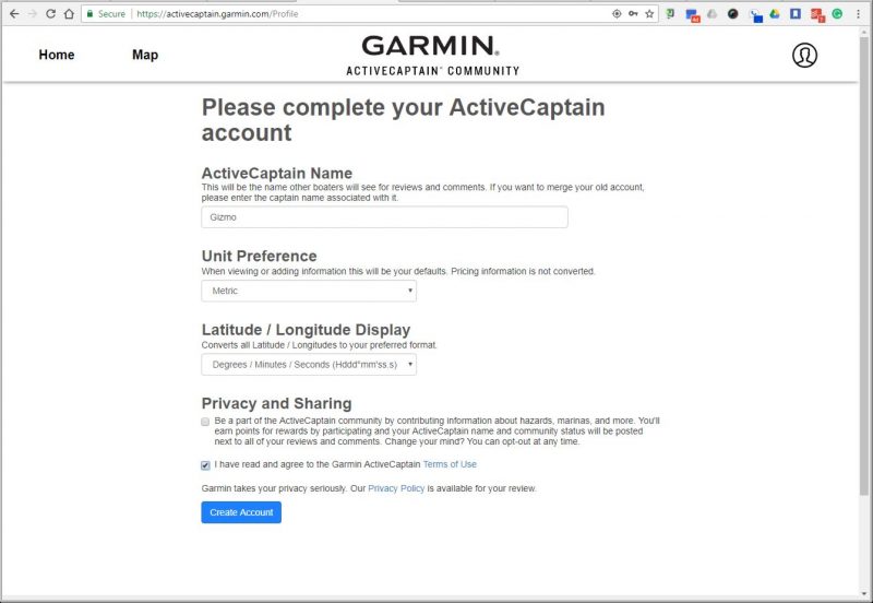
Above is the next and last sign in page a new user will see. As long as you choose an ActiveCaptain Name not already in use, and agree to the ACC Terms of Use, the Create Account button goes blue and you’ll have instant access to more than a decade of boating info contributed by many thousands of active users.
As indicated above, new ACC users need not even agree to contribute to the database, though hopefully they will. Making it easier for all sorts of boaters to view and edit ACC info — you’ll see how that’s improved on PC’s, phones, and tablets below — is critical to the future health of the database. The more active captains, the better (with some qualifications I’ll also touch on).
But how do existing AC users sign up? Note how the ActiveCaptain Name help above says “If you want to merge your old account, please enter the captain name associated with it”
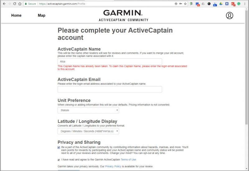
But when you enter your old AC name and the page responds with the message “This Captain Name has already been taken” in red, DO NOT PANIC.
In fact, though phrased negatively, the message is actually good news meaning that the new ACC database remembers your old AC name (and so did you). And rest of the red warning — “To claim this Captain Name please enter the login email associated with this account” — is why the ActiveCaptain Email box just popped up below. If you can also remember that — remember, it’s not necessarily the same email you used for your Garmin account — you will get your AC name back (and anyone later trying to use it will get the red message, “That captain name has already been taken, please provide a different value.”)
So in my experience retaining my 11-year AC identity was easy, but as we’ll see, the value of that identity seems to be diminished in the new ACC, at least for now.
(I’ll also note that Panbo reader Hartley Gardner struggled with the merge process, apparently because his AC email address was too long for ACC’s entry box, but he figured out a “bizarre” solution described in this comment.)
Where’s my data?
The new ActiveCaptain Community site is wonderfully simple, essentially some vague Home page marketing, your barebones profile page, and the very rich data Map. And again that seems nicely accessible for new users while also focused on what AC has always done best, though again confusing for existing users. Where, for instance, are eBoatCards, shared routes, and captain profiles that once showed your boat particulars, homeport, and more (if you wanted)?
The ACC help pages provide some guidance and, frankly, I thought that eBoatCards was a nice-but-failed-idea long before Garmin acquired AC. But Garmin does not mention the complete absence of Captain profile info (beyond our chosen names) anywhere, and I miss the ability to click on a comment’s author to usually learn more about their boating style and AC history. It helped evaluate the validity and applicability of data edits and opinions. And, heck, even a curmudgeon like me feels sociable once in a while.
It’s possible that Garmin still has the old AC captain details, but deleting it may have been necessary to meet the new GDPR personal data regs, which you probably know a lot more about since it came into effect last week with a blizzard of “We’re changing our privacy terms…” emails.
At any rate, the new ACC is quite different from the old AC, but I think that Garmin has just gotten started. Regarding shared routes, for instance, I was glad to read that they’re only “removing this feature to redesign it and bring it back in a better way. We will make it easier in the future to create, manage, and share routes.” (I hope the improved version will will support custom waypoint names, which many charting programs and MFDs can handle these days, and which were sadly left out of the original AC implementation.)
Map viewing
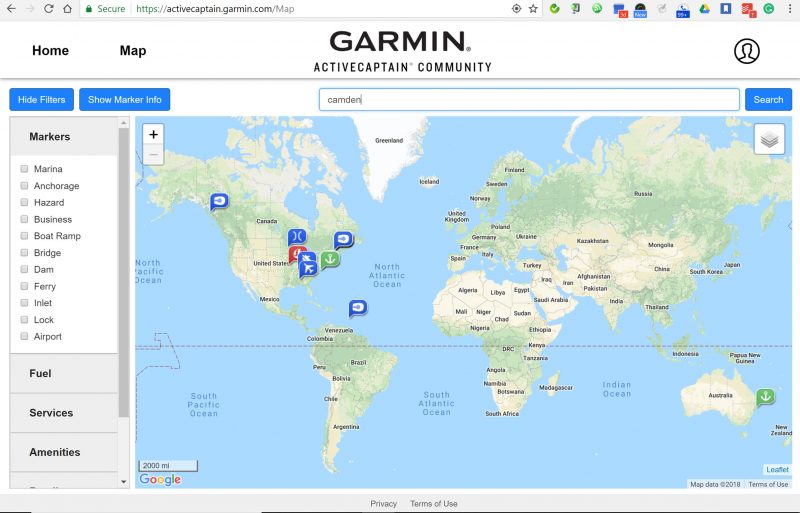
Nevermind that opening the ACC map now usually zooms you into a satellite photo map of some mid-America farmland, because hopefully that will change soon. Besides, I’ve found that switching to faster-downloading land maps and unzooming/panning to my area of interest is easy even with a slow internet connection, and the new ACC search facility is a great shortcut.
But folks used to the old AC site have some unlearning to do. For instance, the search seems to work strictly on ACC marker names, not geographic place names, captain names, or anything else. “Camden Maine” or similar gets nothing, while “Camden” goes global.
Also, marker types filter differently now (and, yes, there are many more as the old “local knowledge” category was subdivided). By different, I mean that all markers show for a particular search or area unless you check one or more, and then you’ll see just those. I’ve gotten comfortable with how it works, but it’s not the only aspect of the new ACC that will make old AC users feel like they’re in the upsidedown world.
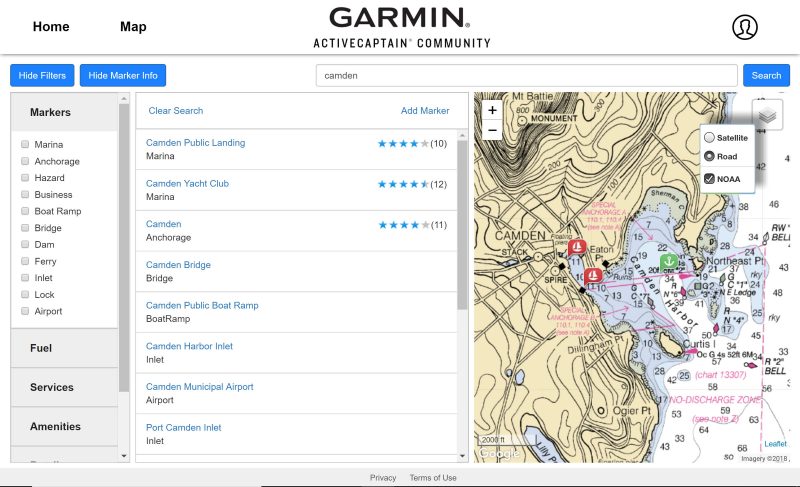
Search is also a strict filter, which is why this view of Camden only shows markers with “Camden” in their ACC name. Click “Clear Search” at the top of Marker Info window and all the available markers in the area will show, at least until you start clicking on categories in the Filters window.
Actually, even all the categories organized under Fuel, Services, Amenities etc. are filters, so you can conceivably hone the marker display to only the marinas that offer diesel, free WiFi, and pet access. And don’t be surprised if fishing-related filter categories show up eventually, because that’s a vast active boating population that Garmin also serves, and they could contribute a lot to the database.
But right now the detail filtering mainly serves to show how incomplete the ACC database details are, useful as it’s been. Either that or only one marina out of about 20 around Longbeach, New Jersey, has showers.
Info editing
While the new ACC filtering is useful and potentially very powerful, the new data editing facilities struck me as major improvements on day one. But pardon me if I also use my screenshots to illustrate an existing AC issue that improved editing should help with.
For the most part, AC info has made boating — particularly cruising, so far — easier and more pleasant. But unnecessary Hazard Markers can add unnecessary anxiety and, in the particular case of the New Jersey ICW, I’m sure they’ve completely scared off some boats that may well have enjoyed those shallow but interesting waters like Gizmo and I just did.
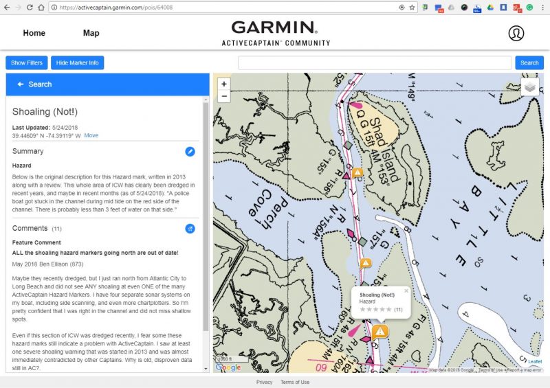
So note at the bottom of the filtered Marker list above how a couple of the Shoaling Hazard marks are now named “Shoaling (Not!)” — changes like that used to be impossible in AC, and I’ve just gotten started!
I wrote the comment above last Wednesday, right after I’d encountered many Shoaling Hazards that had no relationship to the reality I could see on Gizmo’s many sonars and chart plotters, or feel under her 4-foot plus keel. It was also a test to see if data entered right before the ACC database change on Wednesday would make the transition, which it did.
In old AC world, my comment was pretty much a futile gesture. In fact, most of the many Shoaling Hazards in this area have multiple comments about how the situation was no longer true, if it ever was. But in new ACC world, I discovered that I could usefully rename the Hazard Marker — never before possible — and that the new interface made any sort of editing easier.
Actually, you can delete a useless marker and it happens instantly across the database. Which is definitely upsidedown world for AC regulars and may sound dangerous to everyone else, but please hear me out.
I did, in fact, delete POIS #49734 (see the POI links at the top of the screenshot) and it’s gone everywhere I can see updated ACC info. That’s why activecaptain.garmin.com/pois/49734 gets you to a “The point of interest was not found” message while activecaptain.garmin.com/pois/64008 gets you to the Shoaling POI with my Wednesday comment (if you are logged into ACC).
Yes, it sounds crazy to let ACC users delete Hazard Markers, but I think it shows wisdom and courage on Garmin’s part. Because while deletions “take effect instantly,” they “will later be reviewed by a community admin” according to the Support Page. In other words, Garmin is treating ACC users with trust and thus giving them the gratification of making changes fast. But as the wisdom goes: trust and verify.
Garmin is also promising that “we will never edit a review. In rare instances an ActiveCaptain review is removed if it does not meet the guidelines of the terms of use of ActiveCaptain. We always inform the user and give them time to update the review before it is removed.”
Aren’t these the ways a truly useful and dynamic crowdsourced information tool is designed?
ACC on mobiles
- Use location on mobiles not working yet
- No NOAA charts on iPad but great sat photo maps everywhere
- ACC reviews keep coming
All the previous screenshots were taken on PC’s using the Chrome browser and Windows 7 or 10. And it used to be that accessing the AC website was mainly done on PC’s, due to issues with map displays and small-screen interfaces. Well, hurray, those days are over. iPhones and iPads apparently still won’t show the new ACC’s NOAA charts, but the standard mapping and hi-resolution sat photo mapping seem to work well all over the planet.
As my first iPad screen above indicates, GPS-aware mobiles should be able to zoom right into your location, though that’s not yet working for me on iPad or Android phone. However, using the new ACC site on either the 10- or 6-inch touchscreens seems easy, including adding edits and short reviews.
Open the iPad Pro 10.7 screens above, and see if you agree that they could be useful for planning or even underway.
- NOAA charts on ACC Android
- Sat photo maps with prison ship
- Data view — really?
- Data entry test on phone
My Google Pixel2 XL Android phone does show the NOAA charts, which, incidentally, zoom into smaller scales than they used to. I’m heading up the always-interesting East River later today, but this will be the first time I was aware that the floating correctional center across from Rikers and La Guardia may have “underwater mines the haul (meaning hull, I think).”
Of course, that may be true, but if I can make a determination one way or the other (without getting blown up), I’ve already tested that editing ACC on my phone is quite doable.
ACC, what’s next?
I don’t know any secrets, but I suspect that there’s a lot more coming to the ActiveCaptain Community. It looks like Garmin did have to fix the old AC to meet the GDPR (despite what skeptics said), but they decided to do a teardown instead of a rehab.
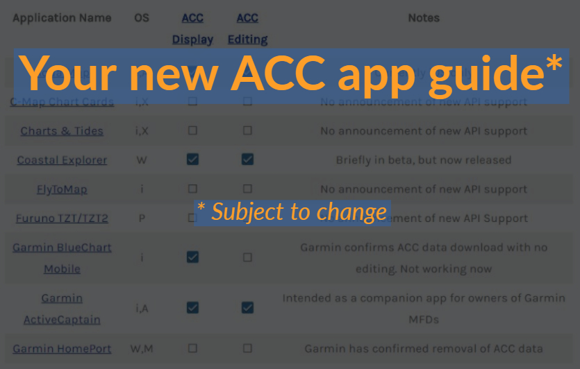
I obviously like what I’ve experienced so far with the new ACC website and revised database, though I’m curious about the experience of others. But what isn’t entirely clear yet is how many developers have adopted the new ACC system so the info is available for planning and navigation on a wide variety of apps and multifunction displays, yet another critical aspect of a healthy crowdsourced service.
That said, I can tell you that Coastal Explorer and Aquamap are both showing my new ACC edits and reviews — some of which I created in CE — and that Ben Stein will have an overview soon. And, dang, I wish Garmin was less clumsy about this subject on the new ACC site.
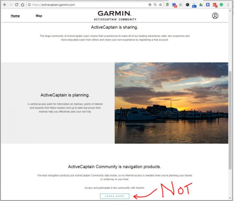
“The best navigation products put ActiveCaptain Community data inside, so no internet access is needed when you’re planning your travels or underway in your boat” is a great concept, and one I believe Garmin truly supports. But then the Learn More link goes right to the ActiveCaptain App instead of the list that includes the AC app. Do not be confused; do not panic.
PS 5/28: We did indeed fact-check the unusual Vernon C. Bain Correctional Center hazard marker yesterday — see Android screens above — and it seems that “Be sure to keep clear by at least 400 feet, they do have underwater mines along the haul” is based on warnings along the hull of the floating steel prison that read: “CAUTION 4 INCH ANODE PROJECTING BELOW WATERLINE” Also, though Gizmo got closer than 400 feet, there were no explosions.






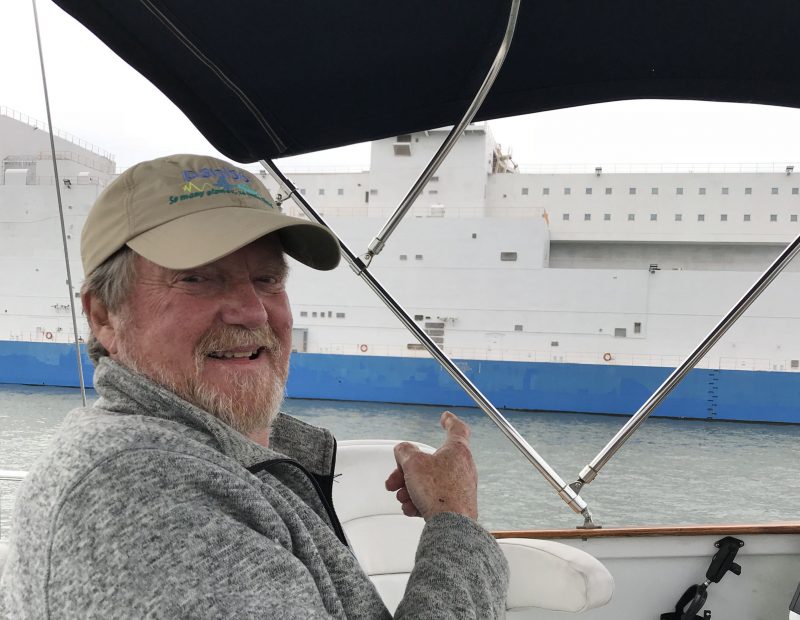


PS Here’s wishing a great Memorial Day to all U.S. Panbots. Gizmo will proudly show the flag from Staten Island to City Island, both somewhat oddball outposts in the wildly diverse and wonderful city of New York.
And a wonderful Memorial Day to you, Ben! BTW, the “bizarre” problem was rooted in a common email address used for both my new Garmin account login and my olde AC account. I fixed the issue by creating a new Garmin account with something besides the offending email as my login and everything worked as it was supposed to. Now I’m wondering if I’ll be able to change my account email later on..:)
Great summary!
Well, that’s odd because I had no problem merging my old AC account while using a Garmin account with the same email address.
Yeah – hence my use of “bizarre” 🙂 But when I tried the new account, the “message in red” changed to allow me to enter the email associated with my old AC account and link ’em up. As long as I can change the login email for Garmin, that’s fine with me.
Ben, A happy Memorial Day to you as well.
Wish I had your post when I tried to tie my old AC account to the new ACC. When I got the red warning that the Captain’s name is already in use I tried a few old emails to make the link, but was unsuccessful. Yes, I immediately panicked and continued the sign up process under a new name. Once I had the new account established I realized I could no longer correct a dredging comment I placed last year (the area is now seriously shoaled over). Not being able to remove and / or clean up what I said in that comment may lead some poor mariner to navigate the entry into Herrington Harbour, North thinking all is well when it’s not. I’m going to make a call to Garmin Support after the holiday to see if I can roll back my new ACC registration and start over. I feel a responsibility to keep track of and correct past AC comments. Wish Garmin had made the transition from old account to new a smoother process. The RED lettering is going to throw off a lot of people trying to make the switch if they haven’t read your post above.
I hope that goes well, Rich, especially since your Garmin account is probably associated with the Garmin hardware you own. If not you could just create a new Garmin Account and then try to claim your old AC name again.
Does the new Garmin Active Captain android app have a background base map (chart) that is usable and has reasonable resolution?
All the ACC browser displays I tried — Windows, Android, and iOS — show a choice of global base map, global satellite photo maps, or NOAA charts for U.S. waters. Except that the NOAA charts do not work on my iPad (probably an iOS limitation).
They call the base map “Road” but it includes some terrain features. Photo and base map resolution seems to vary some around the world, but is pretty good.
Ben, I wonder if any of those other than “Global base map” would work without an Internet connection? My iPhone doesn’t get the NOAA chart either, though it happily lets you check the box 🙂 Anon, the “Global base map” is VERY low resolution.
I don’t think that the ACC website works at all offline. That’s why apps that download ACC data and maps/charts are so important.
Also, I now notice that the base “road” mapping is credited “Map Data c2018 Google” plus I’m seeing names of small streets, landmarks, and a couple of ACC markers in Port Moresby, Papua New Guinea. The shoreline is detailed too, as confirmed with the photo map, which seems nearly as hi res as one here at City Island.
I just tried it by turning on “Airplane Mode” – using the “ActiveCaptain” ap installed in my iPhone, the charting (but not the display of AC data) with the basemap works fine (albeit with low resolution) but the online access, of course, doesn’t work. I think if I had linked it to my chartplotter (would that work with RayMarine? I dunno!)) it would use those charts just fine while offline.
It does make me wonder if I could somehow cache AC data for offline use…
I’m getting confused now, Hartley. The ActiveCaptain App certainly can cache all ACC data as well as Garmin charts, but it’s an entirely different animal than the ACC website. Also the app’s base map is from Garmin and much lower detail than the Google one used on the ACC site.
Anon’s initial question was regarding the “Garmin ActiveCaptain android ap” so I assumed we were talking about the ap, not the web access. So I need to figure out how to make it cache the AC data, then (or maybe I shud wait until Garmin updates the Navionics ap to accomodate AC data, since I use Navionics, not Bluechart). In any case, it seems unlikely I’ll be able to link the Garmin AC ap with my Ray chartplotter 🙂
Thanks for unconfusing me, Hartley. Navionics Boating app support for ACC info is slated for sometime in 2018, and I imagine it will be thorough.
Sorry, Anon (and Hartley), I succumbed to the very same ACC/ACapp confusion I warned about!
And, no, the ActiveCaptain App does not have a usable base map. The ACC data overlay only works well with the Garmin charts you can download for free IF you already own them on a registered Garmin display.
Signing up on the new AC website was easy, but I would like to point out (as Richard Cassano has) that anyone who previously had an account should merge their old account instead of opening a new one. If they open a new account, not only will they no longer be able to amend their previous posts, but they will loose all of their accumulated points. Garmin have said that there will be some kind of awards for points, although they haven’t said what the rewards will be.
One thing that hasn’t changed, and probably never will, is AC’s propensity to modify some unfavourable posts. I had one post modified, and another entirely deleted. Of course allowing very unfavourable comments to remain is not how to “win friends and influence people”. On the other hand, some posts are obvious schilling, and should be deleted.
Nevertheless, taken as a whole, AC is a valuable asset, and I look forward to future enhancements.
Note Garmin’s stated claim: “We will never edit a review. In rare instances an ActiveCaptain review is removed if it does not meet the guidelines of the terms of use of ActiveCaptain. We always inform the user and give them time to update the review before it is removed.”
Via email (thanks, Chris!):
“…back to the new site. It’s modern and quick. Where the old site required several clicks to search for points of interest, the new site appears to be search focused with the search bar itself front and center. Filters are much more usable and understandable. Reviews now appear in the same browser tab. In the last iteration of AC, clicking on reviews would launch a new browser tab with only the reviews. This required you to first realize this, and then remember to close the tab when you were done reading the reviews. The add market functionality is much more user friendly and walks you through the creation of the marker, along with a more friendly way of positioning the marker than prior iterations.
What’s missing? It would be nice if you could easily see the points of interest you’ve contributed to in the past. At times I would like to update these but you need to remember whether you’ve added to them in the past. You still need to zoom in pretty far to see if there are points of interest in an area. It would be nice if they could adopt the functionality other websites use for this – show the number of markers that would be displayed if you zoomed in farther. For example, if you look at Long Island, when zoomed out it might have one marker that shows 523 (I made this number up) to represent that there are 523 markers on a more detailed zoom level. Zoom in some, and it might display 3 markers each with a number. Zoom in farther and finally it will show individual markers. It gives you an idea of the popularity density of an area. Lots of markers, lots to see and do and access. Very few markers, more of an out of the way spot. It would be nice to see highly recommended areas based on some aggregate of reviews across multiple points of interest (scenery, services, etc.) and I’d love suggested itineraries to come back. I’d like AC to not just help me figure out what’s in an area once I’ve selected it, but also to help me select an area to visit in the first place.
So that’s what I think of the new AC.”
I should note that the new Garmin Active Captain app is not compatible with older iPads. I have a 3-year old (3rd generation) iPad, and trying to get the app I get a message “Garmin Active Captain is not compatible with this device.” Not sure I want to buy a new iPad just to get the app.
Seems like bad luck, as the AC App seems to be compatible with some 2nd gen iPads:
https://itunes.apple.com/us/app/garmin-activecaptain/id1116089313?mt=8
But if offline ACC data is what you’re after (as opposed to Garmin marine hardware integration), Aquamap seems to run on all iPads:
https://itunes.apple.com/us/app/aqua-map-marine-boating-gps/id919552329?mt=8
Ben, while Memorial Day is over, thoughts of why we have it will hopefully never be over.
I had a different experience. I read part of your article and plunged into ACC and used my old email address, which worked, and I was in.
On the topic of the map it seems that every time you setup Markers, once you leave the map and come back in you need to re-enter the info, not very friendly. Also, once you are in an area, Oswego, as an example, and exit, re-entering brings you back to the USA display which then goes to someplace USA mid-country. Again, not very friendly.
It would seem that maintaining your Markers (it would also be nice to see if a marina has a pool) and previous location for a search would be helpful to those of us on the move.
Otherwise, it is just a step to get back into AC thru ACC and it is easy to see this is a first alliteration of a product to come. Can’t wait to get back on the boat so I can see how all this will help me update my Garmin products. I have the most recent update and look forward to having Garmin remind me that another is available.
Thanks as always for the benefits you provide to the boating community. Very helpful.
Maybe we’ll cross paths as we will be at the AGLCA Trent Severn Waterway briefing on June 29th in Trenton. Will you be there?
Take care, travel safe.
Thanks, Charles, but it’s my Panbo colleague Ben Stein who is a Looper. I’m just loopy.
I agree that returning to your last location would be nice, if possible, on the ACC website. I also like the idea of favorite markers, like you can save Places on Googlemaps.
Well, at 10AM Eastern on a Tuesday, Garmin’s Tech Support phone line says it is “more than an hour wait” to talk to a support person. I wonder how many of those calls are regarding the AC to ACC transition. Usually a call in the morning will have only a slight delay. It seems to me there is no going back to the old Captain name if you screw up the initial ACC merge. I’ll try calling again later today. Part of this is my problem since I have used different variations of email addresses and passwords over the years. Many have been saved in browsers that I mistakenly deleted. So right now, I’m in “password chaos” with an email identity crisis. Is there a diagnosis for that?
Rich, maybe the support team took a break to beat up on the developers who came up this intimidating “merge” process? (But who were working under a severe GDPR deadline, let’s acknowledge.)
Ben Stein pointed out that the new ACC sign-in could simply say something like, “If you want to merge your old AC account, enter your existing AC Name and email address below.”
If that didn’t work, you would likely presume that you got one or other wrong (which would hopefully be confirmed by a site response anyway). But you likely would not presume that your old Name was gone forever or claimed by someone else.
At any rate, I see no evidence at all that failing to get the merge right means “there is no going back to the old Captain name.”
I finally did get through to a very patient Garmin Support person. After explaining how I screwed up the ACC merge and lost the ability to edit old comments the support person said there is nothing written to guild him on how to fix this problem. He was truly stumped. The question was escalated up the chain to the division that manages ACC. I should hear back in a few days.
Interestingly, I got a reply today to my query that I sent Garmin a couple of weeks ago when they first announced the 5/23 changeover. They utterly failed to actually read or answer my query, and answered what I suspect is someone else’s question 🙂 Since my original query is now moot this isn’t an issue, but I suspect the poor Garmin support people are really getting hammered by the AC changeover – and apparently without help from their management.
Hartley, I understand what you are saying here. On my phone call with Garmin Support he tried to rephrase my question in terms he could answer. “Yes, you can edit your old comments….” it took a few tries to get my point across that merging old and new AC – ACC did not work for me and therefore I had no access to editing old stuff. I’m not optimistic that a solution is available for those who messed up the initial merge of accounts. If that’s the case I’ll just move on and use my new ACC to post comments.
Noooooo. Say it ain’t so … I logged in (and registered) today after seeing this post and tried to perform my favorite function. The first I checked for is missing.
My most frequent use of AC, including 2 weeks back, is to lay down potential routes and obtain distances for sailing on Long Island Sound. For example knowing the direction of the current I might have a direct route, and an indirect route that keeps me out or or in Long Island Sound current (which I obtain from Eldridge), and then make a decision what I would do.
I don’t see how, but maybe the interface is different and the function is still there?
Dan, much is gone, but routes are coming back. Please see entry for details.
Ben accurately describes the way the search function works but he doesn’t seem to be as frustrated by it as I am. Here’s an interesting task, go type “Norfolk” in the search bar of the new ActiveCaptain Community live map. You’ll get a list of 20ish Norfolk Southern Railroad bridges throughout the US and Tow Boat US Norfolk. You won’t find any listing of marinas or services in the Norfolk Area. Garmin appears to have implemented a literal string filter; not a search engine. That’s too bad, and in my mind way less useful. I’m hopeful Garmin realizes the value of proper search and plans to implement this ASAP.
I also note that, in addition to routes not yet being implemented, distance measurement is also absent. That’s a tool I find very valuable for planning purposes. Lastly, I think in nautical miles when planning my trips. I noted that when you create your account you’re asked to select between statute and metric measurements. I’m hoping that when some of the route planning tools come back that nautical miles will also return.
Another one here with signup issues with the old name and email.
Before you posted this, I tried to sign up with the old AC name but got the dreaded red message but did NOT get a box to put in the old email, so I changed the name and got what I assume is a “new” account.
I too will email/call them to see if they can hook them together or at least delete the new one so I can try again.
The social aspect is less powerful.
Unable to add new markers, unable to edit the location of existing markers that are inexplicably in the wrong location. (e.g. Coney’s in Huntington)
Navigation markers I have created as an early user of AC are missing, or maybe need to be searched for?
Many markers don’t readily show up unless searched by name. For example our local marine stores in Huntington don’t appear as markers unless you specifically search on their names, e.g. Compass Rose, Coney’s, and West Marine do not appear unless you search by name.
Some markers are missing fields, for example I recall I specifically put in a mention of Compass Rose, Coney’s, and West Marine in Willis Marine, and don’t see it there and no good choice of fields where to enter it.
Dan, you can add new markers easily, though the process is a bit different. Click on “Add Marker” and walk thru it – I added a Hazard marker yesterday that I had meant to add last summer & forgot about. (Its on the CT River, just above the I95 bridge). You can’t see the “Add marker” button unless you are at the top search level, however. If you are looking at a marker, “Move” is an available option – and not just for your own stuffe.
It’s amazing Jeff programmed this basically solo, including the ground breaking integration with 3rd party maps at the time where you could point and add info, then buffering of maps and data in our devices, and then this update/replacement feels so not groundbreaking. We miss you Jeff!
Ah, I see, after a search the add marker option disappears as do most of the icons. Best to scroll over to where you want to be on the map then to search, then all the markers in the area will appear.
If you click on the left-pointing arrow next to the “Search” at the top, you go back to the top level and the “Add Marker” reappears. 🙂
Went onto Garmin’s ActiveCaptain site at mid-day today and with the aim of merging my ActiveCaptain accounts and got this message:
“Captain we encountered a problem and our server could not complete the request.
“Why did this happen?
“Our servers are just too busy.
“We are having an issue and are most likely working to resolve it
“We forgot to weigh anchor and you can try reloading the page”
Still getting the same message six or seven hours later.
We’re seeing what happens when the founder moves on and the new company tries to move ahead.
Milt Baker
Hi Milt,
I just tried loading Garmin’s Active Captain Community website and had no troubles. I loaded it both logged in and logged out as well as loading the live map. Are you getting this error only when you try and merge your account or when you do other things on the site?
Hi Milt,
Another way to look at it is that we never got to see how the founder would have handled GDPR. I’ve had several companies wipe out my personal data, and even more that don’t even dare sent me another marketing email unless I explicitly permit them to (again).
And, as far as I know, none of those companies had allowed many other companies to download and distribute my personal data, like the old AC did. (Not that I cared wit that my name, boat name, home harbor, etc. were all over the digital place.) Then again, and as inconvenient as this all is, I do sense that GDPR was needed, at least in terns of the big guns like Facebook and Google that really caused it.
And another way to look at all the upset toward Garmin is to check out the two PS additions I made to that first AC entry in 2007:
https://panbo.com/activecaptaincom-the-poi-bomb/
There were many in the online boating community who were absolutely convinced that the AC founders were up to something sinister. And I wonder if some of those same nattering nabobs of negativity are now the ones who think Garmin is sinister (and the chief founder is a god). All of which is nonsense.
End rant!
Ben – my regular job is managing software development in a multinational petrochemical company and can tell you that implementation of GDPR is a gigantic PITA. The regs are just vague enough so that we’re unsure of exactly how to implement them. And then there’s the very questionable value of the regs themselves. Lots of work with little value add. So not surprising that we’re not seeing much forward progress with Garmin’s AC app while they also sort this out
A very good question, Ben!
I tried again, went to the map, and tried to get data for Port Everglades’ 17th Street Bridge and received the exact same error message. That told me that the problem may be my browser or operating system–using Google Chrome on a MacBook Pro (completely up to date with the latest software). So I closed Chrome, opened Safari and VOILA! . . . . looks like I was able to successfully merge the accounts and I was definitely able to get data on the 17th Street Bridge. Thank you, thank you, thank you!
That said, Chrome is a popular browser and it’s always worked for me with ActiveCaptain before, so something screwy is going on. However, I stand warned.
This is still feeling a lot like a beta test to me! I hope I’m the only one feeling that way, but I suspect not.
Thanks again, Ben, for kicking me in the butt and getting me out of the loop I was in!
Milt
Milt,
I did my testing in Chrome as well, but on a Windows machine. Hard to say if the issue is one of browser / OS compatibility or some peculiarity within the browser instance. You might try deleting cookies and clearing cache as well. Another useful diagnostic tool is to try the same flow in the browser in incognito mode. Incognito mode stops your browser from using existing cookies, stored passwords and cache. You can access it by using the top right three dot menu and select “New Incognito Window”
Ben E. and Ben S.,
Panbo readers, myself very much included, owe you both a great debt of gratitude for all you do to help us see the world of marine electronics with a clear eye. Panbo are blessed that you both have the ability to cut through the fog and the B.S. and use that ability routinely in your posts here.
Please keep on asking the right questions calling things the way you see them. I know you will.
Milt
Milt
Milt,
Very kind words and very much appreciated. I believe I can speak for both of us when I say we cover this because we love this stuff. I hope it comes through in our writing and I hope we’re able to help others understand what’s happening.
Ben
Ben,
Could they have meant “mines…along the WALL”? ie the seawall ? That would make more sense from a security/anti-escape method to me.
Highly doubtful. For one thing, if you managed to jump off “The Boat” and get up the nearest seawall, you’d still be inside the fence.
https://en.wikipedia.org/wiki/Vernon_C._Bain_Correctional_Center
For another, is there any prison in the U.S. or any other country using mines for “security/anti-escape”?
The whole “mines” deal sounds pretty fanciful – in order to mine a navigable waterway I would assume that the USCG would have to approve – and I can’t conceive of them permitting such a thing without extensive public notice, warning signs, lights and an active patrol boat in the area. We’ve been through there, too, and none of those are there. I’d go with “urban legend” 🙂
I hope Garmin restores the fuel price comparison tables that were in the old Active Captain.
That would be nice, but you can filter down to marinas with the kind of fuel you want and check them out. And there are other good lists…
https://panbo.com/marine-fuel-prices-why-so-hard/
…which I should have looked at recently. I just paid $3.90 a gallon for diesel in New Haven, and that was the cash discount ($4.10 with charge card), whiel the remaining fuel in the tank only cost about $2.45, charged, about a month ago at Top Rack in Norfolk.
The spread can be astounding, though I see now that Top Rack is up to $2.84:
https://www.waterwayguide.com/fuel-price-report/5
(I didn’t get much here, and had many other reasons to be at the fuel dock.)
Hi Ben
Just spent some time on the AC Community website.
I was able to easily add a review to an existing anchorage. I would say that it was certainly as easy as before.
The good thing to point out is that you do not have to have any connection to Garmin products to use this site. I thing this is extremely important to note and promote.
The interface seems fast which is good for us away from the home computer. I think that it is a good start at retooling the AC experience – yes I agree with the functionality comments above and I trust Garmin is reading these comments.
One issue that I would like to know is if the Garmin Homeport program will be updated to be able to sync with new data. I use this all the time for route planning. The old data (up to 05/23/18) is still working in the program but it will now not sync for updates. How would one ask this question?
That’s good to hear, Ron, and I agree that Garmin has designed the new ACC site for all kinds of users, certainly not just Garmin marine hardware owners.
Another sign of an open attitude is that ACC partners can display the data to users without the user having to log into Garmin/ACC at all. No impediments.
However, sorry to tell you that Homeport will not be updated to work with ACC. That’s confirmed by Garmin.
Ben
Thanks for the response
As for a follow-up,I checked for pending updates for Garmins HomePort and there is one available. But I read the features and one is removal of AC. So I won’t be making that update. I will keep what I have.
One Chart? I just don’t get it. I have ACC working between my 7612 and iPad. I own two regions of G2Vision charts and an update to the original charts that came built into the 7612. On the iPad, when I go to “My Charts”, each has a price tag on it, but I already paid for them. Then I get a notice that there are updates to the charts I own. A few days ago the price next to each G2Vision region that I already own was $449. Yesterday the price was $229. and today it’s back to $449 The price on the renewal I just bought for $99 Is now $49.
I also have other iPad navigation Apps with charts that update everyday for free. Navionics and SEAiq constantly update. I like to have up to date charts but the organization of One Chart is overly complex, seriously expensive and in light of FREE competition I just don’t understand the value.
Hi Rich, Confusing it may be, but the list of charts in “One Chart” is called “My Chart” because the list is only the charts you already own and have registered to your Garmin account. You can download sections of those charts to your iPad just by clicking on the chart type/area you want, no charge.
https://cdnkey-bb0b.kxcdn.com/assets_c/2017/11/Garmin_ActiveCaptain_OneChart_My_Charts_cpanbo-15779.html
Updating those charts is a separate matter and they aren’t really comparable to other app charts because after you update and download, they will also download to your Garmin plotter. In other words, updating one of those chart cards registered on your iPad is like updating the card itself.
Ben, Thanks, I got that. Under “My Charts” I have updated the G2Vision regions to 2018, however, version 2018.5 is now out and the price next to them is a constantly changing number. One day $449.99 the next day $179.99 or something like that. This I don’t understand. Also, putting a price on what I already own is confusing. I understand this is the price to upgrade to the new 6 month updated charts but Garmin should have a seperate page in “My Charts” for update purchases. I see there is a separate online “Store” for new purchases which is fine.
I downloaded a combination of all three chart products I own that covers a voyage from the Chesapeake to Maine. This has both G2Vision and plain G2 charts that are over 1GB. I have to wait until I get to the boat to connect my iPad to the 7612 and see how it transfers. I guess there is no need to plug in an SD card with the latest G2Vision region once I connect ipad to chartplotter and load the charts I selected. That’s nice!
I certainly don’t understand the price changes you are seeing for updates, and I haven’t so far seen it myself. The screenshot I put in the comment above shows what my My Charts looked like last fall. Now the free 2017 updates were used and I’m seeing $400 for the two G2 2018.5 updates and $85 for BludChart + LakeVU HD 2018.5
I’m one of the few who messed up that big Merge of the old AC account to the new ACC. This mostly happened because I could not remember which of the many email address variants I used way back when ActiveCaptain was first started. to continue the process I registered ACC as a new Captain (GrayEagle). Now the problem: There was one particular comment I authored that was a safety issue on Shoaling. If I could, I would delete it. because I was unable to access my old account and edit this comment I clicked on the “Report” button in the lower left corner of the comment and told my story as to why this comment needed to be deleted. When finished I clicked on the send button and the comment was gone. I presume it will be reviewed and some action taken by Garmin’s ACC Support. In any case, its a way of addressing serious issues with old comments that you lose control over if you did what I did and registered a new ActiveCaptain Community account.
Rich, have you considered getting a second Garmin Account and using it to reclaim your old AC Name? Of course, you’d still have to remember your old AC email address but I believe the claiming process will give you multiple chances.
If it worked it would be a little messy to have two Garmin acounts each connected to different ACC profiles, but I can tell you that it’s easy to switch back and forth, and also that it makes no real difference to your ActiveCaptain app setup since you can’t edit ACC data in One Chart anyway.
Is anyone else having trouble updating the community data? When I hit update, it goes to 0% but stops and says updated May 15, 2018. I deleted and reinstalled, before it was saying April 07, 2018.
Yes, Matt, I have the same problem. My iPad is connected to the 7612 chartplotter’s wifi. I’m connected via Bluetooth. I have all green check marks for all categories and the Community data is from back in May. Also, my G2Vision chart segments that I selected on the iPad have been loading into the chart plotter for two days – the Spinney ball keeps spinning to no end. My chart plotter only shows the charts that it came with in 2015. I’m back to simply plugging in an SD card with my updated charts and giving up on ActiveCaptain Community. This is way too complex for me.
Richard,
I don’t believe you’re doing anything wrong. Unfortunately it seems Garmin is still dealing with some issues leftover from the migration to the new ACC API that is stopping both the Garmin ActiveCaptain app and BlueChart Mobile from updating data. I’m not sure if that’s also stopping your chart tile updates but I wouldn’t be surprised if the app is choking because of the troubles updating ACC.
Ben S, Thanks.
On the chart tiles – I loaded a good many from two G2Vision regions so maybe this is too much for the App to transfer to the 7612. In any case, I may wait for Garmin to issue an update to ACC and try again. I hope they simplify the App for those who are not experts in technology. Personally, I want to get out and sail and have the electronics serve that effort. I’m not interested in sitting on my boat for hours trying to figure out my electronic equipment. Even the Garmin Support Reps I spoke to on the phone sound frustrated with ACC because they don’t have all the answers.
As of the June 22 2018 update I have all aspect of ActiveCaptain Community working – “My Charts” and all. What a rocky start Garmin, but Now we’re cooking!
I seem to recall that efforts to somehow make Active Captain material available to OpenCPN users never got off the ground. Recognizing the commercial interests of the Garmin folks, is there any hope this will ever occur and we open source users will eventually benefit?
Hi Armond, and sorry soooo late. I think that integrating with the new ActiveCaptain data system is up to the OpenCPN crew. Garmin’s business model for AC is to sell higher levels of business membership/advertising — pretty much just like it used to be with the “first choice” marina program — and so they’ll do best if AC data is used and expanded on in as many places as possible.
https://panbo.com/garmins-activecaptain-marine-business-plan-looks-good-plus-eartha/
Cool. I just noticed that the ACC site now includes Navionics nautical and sonar charts as well as the NOAA charts (in the U.S.) plus the road and satellite maps. This is especially good news for boaters outside the U.S., and they all work fine in Windows, iOS and Android browsers (or at least mine).
https://activecaptain.garmin.com/