
Navionics Mobile, UGC & Plotter Sync
Big, big news in the world of user generated content (or UGC, or crowd sourcing, or whatever we decide to call it): Navionics Mobile 5, rolling out around the world as I write, supports UGC, big time, and it’s central to the company’s “Navionics Anytime, Anywhere” vision of the future. Those screen shots above — which show the new “Community Layer” turned on and off — are from a beta of US East 5.0 running on the Panbo test iPhone, but most all of that UGC work was done by Navionics founder and chief visionary Giuseppe Carnevali when he cruised up here in early September. It would be hard to overstate Giuseppe’s enthusiasm about enabling interested Navionics users to share data of all sorts, some of which can be validated and added to the company’s regular chart database for the benefit of all users…
Captain Carnevali is cruising with quite a collection of iThings these days, though his power catamaran is fitted with loads of dedicated plotters as well. At any rate, the multiple wireless app devices seen below meant that Guiseppe could show me how a UGC change he made on one immediately showed up on the others, no sync routine involved, as long as all were online. What I haven’t seen in action yet is “Plotter Sync” though apparently it’s already been demoed at one show with a Raymarine E Wide. The idea is that you’ll be able to plan a trip anywhere on your smart phone or tablet, and when you step on the boat its fixed nav system, networked to a WiFi router, will see your device and suck up the routes you already created.
So far Plotter Sync details are vague, except for some chatter on the Navionics Facebook page, but it sure sounds good to me, and it’s yet another way that the marine electronics developers are challenged to work with the onslaught of iThings, as discussed earlier this week. And apparently there’s lots more to the Navionics Anytime, Anywhere program — like free apps with chart card purchases, and easy frequent data updates to those cards, I think — but I’ll wait until I can get more concrete info. However, I can share some details on the UGC that’s in the Mobile 5.0 apps now working their way through the iTunes store…
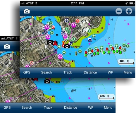
 First of all, the Navionics approach to crowd sourcing is in many ways quite different from what Active Captain has been working on since 2006. For instance, as you can see in the top screens, Giuseppe was able to add all the Camden channel buoys that NOAA tried to include in its chart updates last spring (but which still haven’t made it into any of the commercial charts that copy ENC and RNC data). And had the buoys been on the chart already, but misplaced in several cases (due to a funky private aid application filled out by our Harbor Master), he could have moved them. In the community layer that change would show up with a “x” where the buoy had been. None of this is possible in AC right now, though I was able to post an AC Hazard note about the buoy confusion and see it sync to Coastal Explorer 2010/2011 almost immediately. Then again, Navionics doesn’t yet support the marina ratings, let alone much of the marina detail, that AC does, nor can you see who generated the content, which I’ve come to value in AC.
In the top left screen below you can see what happens when I tap on the Launch Ramp Icon that Guiseppe added to the chart you see way above. In fact, I’ve already edited it, adding the “Information” text, so this is communal UGC now. The next screen shows all the master categories you’ll see when you tap anywhere on a chart and then select “Add Object.” And the top right screen shows how well populated the Buoy category is. Starting at bottom is a bit of the lengthy Marina data input screen, and then the choices available in the Generic Info master category. I used “Text Note” to add more explanation to the channel buoys (and also managed to demonstrate an odd spelling disability I have around a few words like “buoy,” which I’ve typed a zillion times, but can still screw up ;-)…
 Navionics UGC is just coming out of the gate, and there are numerous question marks, like just how they’re going to validate critical data like rocks and depths with enough confidence to add them to their regular chart database. In fact, a comment today on their Facebook page — “In time, Navionics may verify user’s contributions and decide to implement them in official charts.” — is more tentative than what I’ve heard from other Navionics staff. But there is no question that this move validates the whole idea of crowd sourcing in a big way. And there may be no one who feels happier about that than Active Captain’s Jeffrey Seigle, who’s been trying to explain the concept for years. Yesterday, Jeff told me that if he could, he’d do what Apple did in 1981 when IBM finally introduced some competition into the infant personal computer market. Which was to take out a big “Welcome” ad.


Incidentally, yesterday Jeff had enough news about ActiveCaptain (which I can’t share yet) that he too could legitimately start an “AC Anytime, Anywhere” marketing campaign 😉
We sincerely welcome Navionics to the future of crowd sourcing, the collection of information from the community of boaters. Few players understand the power that today’s customers hold. They are no longer passive recipients but active players. This is particularly true when dealing with ones passions, such as boating.
ActiveCaptain grew out of our belief that today’s technology could be used to satisfy the unmet needs of boaters. That enhancing a boater’s role would enhance their experience. We are contacted every day from captains telling us this is true.
We appreciate Navionics acknowledging the importance of crowd sourcing with the introduction of their User Generated Content (UGC) feature to their
charts. We’re honored that a company like Navionics is now involved and look forward to exciting developments to come.
Navionics put up more UGC screen shots on their Facebook page:
http://www.facebook.com/pages/Navionics/111050969965#!/album.php?aid=298552&id=111050969965
And there’s also mention of a new Adobe Air based PC app that supports UGC and went up at their Web Store last night, I think. (Marketing & media relations may be even more “relaxed” at Navionics than Rose Point 😉
http://store.navionics.com/faqs/installation_help
Welcome Navionics to the world of Social Mapping (at least this is how we call it here at Bluemapia). I hope this will help to make this idea more popular for the benefit of boaters and social mapping service providers.
Won’t be long before volunteers start making entries for USCG Notice to Mariners I reckon, or is that happening already ?
Dan, Navionics and the others have staff who enter NTM changes, but we often don’t see them very quickly because the card updates are infrequent. Part of Navionics goal is called “Freshest Data” which apparently means that it will be possible to update a chart card online any time you want. The software that just went up in the Navionics Web Store may have to do with that. But so far it’s only working for European charts. Purportedly all will be revealed here during the Ft. Lauderdale Show.
Dan: Perhaps user generated NOTAMs are not here yet, but user generated chart soundings may soon be. There is a previous posting about ARGUS from Survice Engineering
Ben,I think that anything that speeds up the updating of nautical charts should be welcomed with open arms, and UGC is an excellent one, especially given the current glacial chart update rates we all live with now. That being said, when I bought my first Loran in the early eighties, I was ecstatic. It gave me the bearing and range to the waypoint, and the XTE at the same time. Now I expect my chart plotter to also tell me where to find the nearest ATM, and the restaurant with the best pesto linguine. With many clients, when I teach them how to use their technological navigation marvels, I turn off all of the various layers, and just leave the plain chart on the display. We are gathering data at a staggering rate, and the real problem lies in how to present it. One mans POI is another’s irritant. So how to manage the data is as important as the data itself. The day is already here, if you turn on all of the layers of your plotter, in some places you can hardly see the chart underneath. The real trick will be how to sort out all of this info, and to manage what will inevitably be, millions of available pieces of data covering 88,000 miles of US tidal shoreline.
Navionics Mobile just had a massive price increase that impacts all users. Suddenly Navionics announces we need a $65 annual subscription to get up-to-date charts. What is going to happen to the charts that people download who don’t pay up? Are they now frozen in the current state?
This application just went from the top of my list (because it is fast) to the bottom. I also use SEAiq for its Active Captain data. I guess I’ll now use it for up-to-date charts as well. I just wish SEAiq was a little faster.
Hi Craig, I’m not sure but I think you may be presuming the worst. I believe that the in-app purchase of Navionics+ charts that’s now in Mobile V4.7 is meant to provide new features like Sonar Charts, not take away features that Mobile users already had. I just emailed Navionics for clarity.
Craig, Navionics nicely got back to me right away. Here’s the response to your concerns
*********
There was no price increase. There has not been for quite some time I believe. Instead, we added an additional subscription package that opens the app up to cartography updates that were not previously available. This is no different than the Freshest Data subscription for your Navionics card in a plotter, only at a fraction of the cost.
The app is not “now” frozen, in fact the apps do not received updates to cartography after the initial download by a user. When you buy the mobile application (in this case he has an iPad and an app for somewhere other than the US to have seen that price) you get the Freshest data we have, so every area you download the first time is in its most current version we have available. The app comes with access to Nautical charts. If you use that chart over the course of a season after downloading, you are not seeing the most up to date version. You are using a chart dated back to the time you downloaded it. The exception to that rule is community edits, which we allow access in near real time to updates 100% of the time.
The new subscription in app purchase (not a price increase to the app) Navionics+ on mobile opens the app up to receive both updates to Nautical Charts as well as the new SonarCharts layer. Both can be downloaded as often as the user would like taking advantage of the daily updates (NTM’s, Sonar Log contributions etc). This is not buying a chart per say, this is a subscription service for continued updates throughout the next 12 months. It in no way changes the current app pricing or function. Users may also notice that the price paid for continuous updates in addition to SonarCharts is competitive with even the initial purchase without updates offered by competitors. If a user chooses not to subscribe, they can still continue to use the app and its downloaded cartography, or continue to download new areas not previously downloaded within the coverage area, these new areas will be the “freshest” data we have to offer at the time of download. We do not restrict that in any way.
*********
I must say — probably like you, Craig — that I thought that I could get updated charts on the Navionics app by downloading areas over again. But apparently that was never true, except for the community edits, and when I think about it would have been an extraordinary deal. I don’t think there’s any app that gives you chart updates forever except for the ones that download free NOAA charts.
Yes, you can highlight a region and press “download map” a second time. It definitely downloads something. I’ll bet 99% of their users assumed it was downloading fresh data. Thus I’ll stick to my claim that they are breaking expectations by announcing the system never did what it appeared to do.
I’m going to guess that you can still get chart updates by uninstalling the app and then installing it again. This should clear their database on the i-device. However, if enough people do that, they might be able to add code to limit the number of reinstalls to stop this user behavior.
With respect to “fair” pricing, it is annoying in my case because they want subscriptions for my iPhone, my iPad, and my MFD. All of these devices are getting the same data. In addition, for US waters, they are getting the data they sell for free from the Government.
Competitive apps such at SEQiq fetch the US government data directly from the government servers. The updates are free. Unfortunately their app is very slow in comparison.
Craig
“Yes, you can highlight a region and press “download map” a second time. It definitely downloads something.”
Right, that’s new community edits being downloaded. I don’t know how many Navionics Mobile users mistakenly assumed that the app includes forever Freshest Data, or care, but as noted I was one of them, sort of. I say “sort of” because I was happy to find that when I wrote about the Freshest Data concept I didn’t make that mistake:
https://panbo.com/archives/2012/05/navionics_charts_really_fresh_data_lots_of_it.html
Could Navionics have been more explicit about how the Mobile app chart downloading works? Absolutely yes in my opinion, especially as they’ve been marketing Freshest Data so vigorously at the same time. But I can also see how from their point of view Freshest Data is a unique subscription service with a lot of associated costs and that it couldn’t possibly be forever included in a relatively inexpensive app.
Consider the competitive landscape. I think that Garmin updates charts once or twice a year; you get one free update if you’ve bought a g2 or g2Vision card, but pay full price if you want to update the charts you’re using with the BlueChart Mobile app. I believe that Jepessen C-Map does have a weekly chart data update service but it’s only associated with high-end formats like MAX Pro and 4D, and it costs.
Not even NOAA updates its charts daily. I’m pretty sure that quite a few NTMs gather before a new edition of even an ENC is released. Meanwhile a large Navionics crew is supposedly adding NTMs to Freshest Data almost immediately.
Plus it’s simply not fair to judge global chart companies based on the fact that the U.S. happens to put all the burden for chart maintenance on the taxpayers and none specifically on the chart users. I think that there are only one or two other countries in the world with such a policy. (Don’t get me started on sailors who rationalize the theft of commercial charts using the American distribution model.
At any rate, Craig, how is there any justification to your claim that “Navionics Mobile just had a massive price increase that impacts all users” when the app hasn’t changed at all. Shouldn’t you rescind that claim here and elsewhere?